In an industry often resistant to change, WW Clyde stands out as a trailblazer, seamlessly integrating cutting-edge technology into its everyday operations to drive productivity, efficiency, and safety across the firm’s ever-growing portfolio of projects. This heavy civil contractor has boldly stepped into the digital age, leveraging an ever advancing and increasingly connected ecosystem to transform the way it plans, executes, and documents its projects.


It’s been a path of continuous improvement that began some time ago with solutions such as GNSS-enabled grade control, aerial and ground-based LiDAR, and field-based project management tools. In the last year, the firm has focused ever more on ways to gather quality data faster while enabling a truly connected construction workflow that streamlines data management, drives real-time insights, enhances collaboration, and provides a competitive edge.
A Strategic Tech Focus
With almost 100 years in business, WW Clyde’s heavy civil services and expertise are evident across the Intermountain West, Southwest, and Great Plains. Headquartered in Orem, Utah, the firm’s skillset has long included earthwork, shoring, deep foundations, earth retention, pipelines, drainage, crushing, asphalt, and structural concrete.
The company’s means and methods have necessarily adapted over the decades to capitalize on advancements in equipment, materials, and processes – particularly in recent years. The current pace of opportunities enabled by technology are in many ways transformative, particularly on the jobsite. Case-in-point — in recent years, the company recognized its surveying and site documentation practices were unnecessarily labor-intensive. This led to the adoption of new technology brought in-house.


Lance Greer, director of construction technology for WW Clyde, said, “On nearly every project, we perform a pre-construction survey. That typically involves video cameras and surveying adjacent properties to make sure we have a full understanding of the potential challenges. LiDAR is invaluable on tasks such as this.”
The firm had some aerial and ground-based LiDAR solutions available and would contract external LiDAR surveying services when needed, which was expensive and time-consuming.
“We wanted to bring this capability entirely in-house with a mobile LiDAR solution,” Greer explained. “While mobile LiDAR had traditionally been used mostly by design firms and mapping companies, we saw it as a way to enhance our risk management and documentation practices, and ultimately gain a competitive edge in the construction market.”
It’s done that and much more as the mobile mapping solution has become an essential piece of WW Clyde’s emerging connected digital ecosystem, where data is not just collected, but used across the lifecycle of a project and beyond.
Point Cloud Potential
One of the key reasons Greer and his team were able to consider a mobile mapping solution is the continued evolution of the technology.
“In the past, mobile LiDAR technology was big and clunky, and the high cost was prohibitive. That’s really changed,” he said. Newer, more advanced field-to-finish LiDAR mobile mapping systems offer a more mature, streamlined solution.

WW Clyde relies on the modern mobile mapping solution to collect a detailed 3D survey of the project site. With point cloud processing software, the team is able to extract key features and information, such as existing utilities, terrain, and structures, which are then integrated into project plans and models.
Once processed, the point cloud data is managed in a common data environment, where it can be used in a variety of ways on the jobsite including WW Clyde’s automated guidance systems, to support fast and accurate layout of project elements.
Greer added, “Critical to our technology journey is a truly connected workflow, from office to field, field to office, pre- and post-construction. The mobile mapping solution is a key part of this journey.”
Today, the firm is fully realizing the benefits of mobile scanning and the increasingly connected workflow it enables well beyond the pre-construction phase.
Road Worthy
WW Clyde is heavily involved in large-scale highway, paving and corridor construction projects, often spanning 20 to 40 miles in length. For these types of paving and corridor projects, they use the mapping system to capture comprehensive as-built data, which helps them document the existing conditions before and after construction.
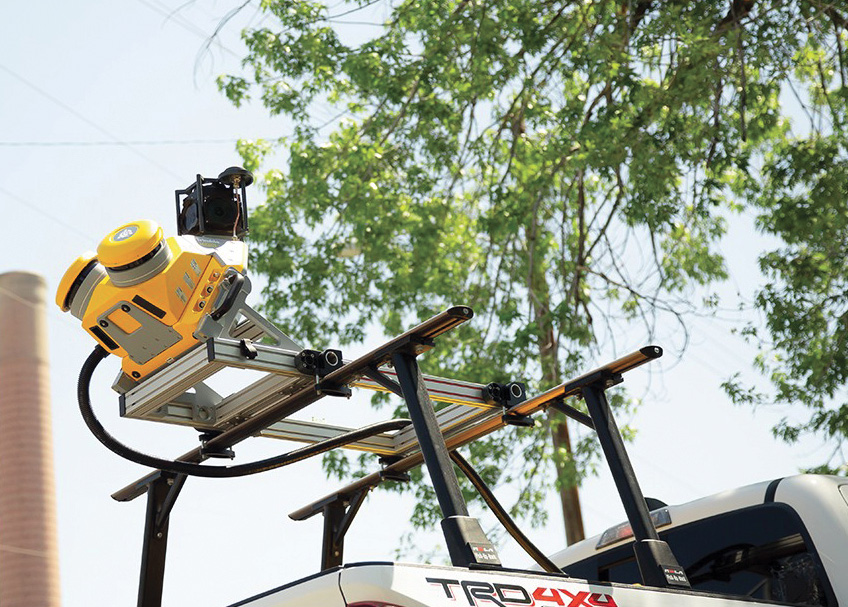

During construction, the firm continues to use the mapping system to monitor progress and document as-built conditions, scanning the site at various milestones to ensure work is performed according to plan. With help from digital site management tools, the as-built data helps project teams compare as-built conditions to the original design, identify discrepancies, and make necessary adjustments.
Upon project completion, WW Clyde conducts a final mobile scan of the site to create a comprehensive as-built record. This documentation serves as insurance for the project team, providing a detailed record of the work completed that they can reference if any disputes or claims arise in the future.
WW Clyde has also realized some unexpected benefits from the mobile mapping solution.
Piling Precision
On a large solar project, WW Clyde was tasked to manage mass grading. This 682.5 MW solar project required the precise positioning of 148,000 pilings. The general contractor discovered the piles for the solar panels had been installed at incorrect elevations and sought WW Clyde’s expertise to determine if current installations could somehow work or if they needed to be redone.
“The fear was they were too low, which would cause the solar panels to hit the ground as they moved through the day,” he explained. “We knew the mobile scanner would be ideal for capturing the precise positions of the installed piles, but they needed very specific locations on the piles. If they knew the top center coordinates of each pile, they could determine the actual elevations of the piles and make the necessary adjustments to the solar panel layout to accommodate as-built conditions.”
The WW Clyde team scanned the entire site and used specialized tools to filter specific data to verify that each pile was plumb. With these customizations, WW Clyde provided the main contractor with a simple delimited text file containing the 3D coordinates of the top center of each installed pile as well as measured verticality.
A Data First Approach
As part WW Clyde’s connected ecosystem journey, the firm holds an all-in-one on- and off-machine service subscription that ensures the latest hardware and software are always available, including a full factory warranty and repair or replacement of accidentally damaged hardware. The subscription covers a range of solutions from grade control systems to base stations, data collectors, and rovers.
Greer said, “The idea is that we’re going to leverage a fully connected workflow and see what is possible. One of our goals is to reduce data duplication by establishing a single source of truth for project information.”
WW Clyde regularly evaluates its ‘connected technology’ progress, working to improve data connections, and more importantly making sure data is readily accessible for decision making.
“We have regular coordination calls with our technology partner to track milestones and identify areas for further development,” Greer concluded. “The progress, which includes the adoption of solutions such as the mobile mapping solution, are essential to improving our operational efficiency, enhancing our risk management, creating a comprehensive, long-term record of projects and driving better outcomes for our customers.”
Vicki Speed is a seasoned writer authoring technical articles that bring clarity and insight to the civil construction industry.