I’m sure many surveyors doing research have occasionally looked for one thing and ended up unexpectedly finding something else. About ten years ago, I experienced that very situation which led to this story.
I was doing some research about the original survey of Township 10 South, Range 7 East, Willamette Meridian in Oregon. This particular township was surveyed by a fellow named William Bushey in 1892. He had been awarded a contract to survey 3 townships in the Detroit area, about 60 miles east of Salem. That contract was welcome news for him because there was a country-wide recession going on from the late 1880s to the mid 1890s. Work was scarce in those years, much like the recession in the 1930s when FDR inherited them from Hoover.

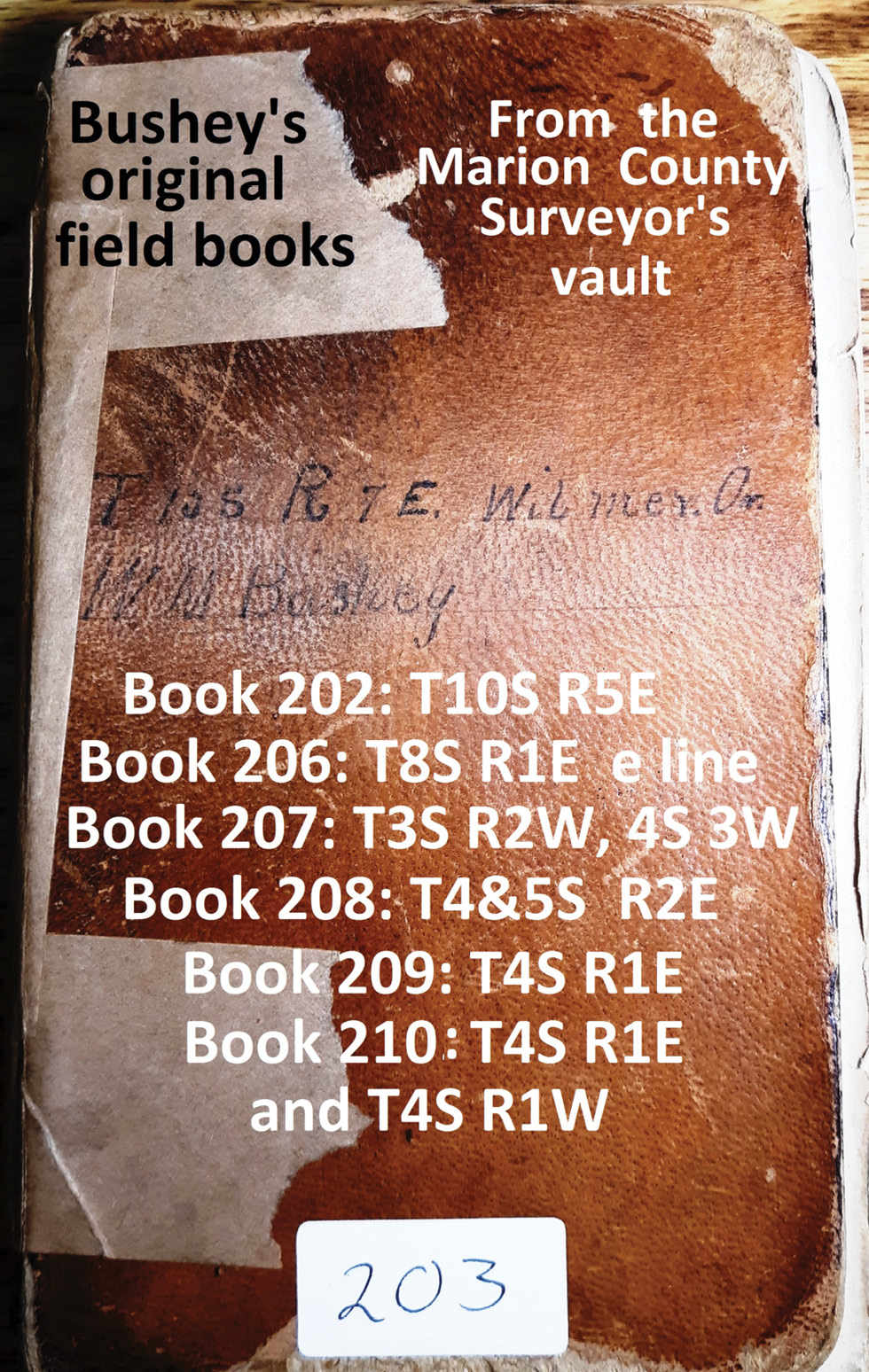
Figure 1
I downloaded the notes and township plats for them from the BLM website and started reading the “calls” Bushey had made as he surveyed the lines in his contract. Those notes were so neat that I started to doubt that they were a direct return from the field. In my own experience, when I went out to search for an original corner, many times by myself, if and when I found it, in my field book I would write down the “pertinent poop” such as size of a stone, bearing trees alive or dead, and the new BTs I scribed and tagged, date, etc. Usually, I would make a primitive sketch of the corner area and head back to the rig a ½ mile or mile away. Within a week or two at home, I would make a much neater sketch with all the “pertinent poop” and then fill out a “corner recovery form” to file with the County Surveyor.
I was talking with a fellow surveyor (about 10 years ago) and mentioned that I was going to retrace William Bushey. To my surprise, he told me that he had seen some old field books in the Marion County Surveyor’s vault that had Bushey’s name on them. Sometime later, I was going through Salem and decided to stop in and see what was in those books. (see Figure 1) It turned out to be a “Eureka Moment”.! I had my cell phone along and proceeded to get pictures of the pages in the book.
When I had a chance to sit down and read them it was mind boggling. When Bushey was awarded the contract for the 3 Townships noted earlier, the exterior lines of Township 10 South, Range 5 East and Township 10 South, Range 6 East had already been run in 1891 by William E. Campbell, who also ran the “Second Standard Parallel South” from the southwest corner of Township 10 South, Range 5 East to the southeast corner of Township 10 South, Range 7 East in the summer of 1891. Bushey would only need to run the east and north lines of T10S R7E before he could start subdividing it. He would have to start at the southeast corner of Section 36, set by Campbell in 1891.
Bushey’s field notes looked “normal” as he described running due North for 6 miles, setting section corners and quarter corners, noting topog calls and creeks along the way and ending at the northeast corner of T10S, R7E, which he then monumented. In 1892, there were no trails within 5 miles of the corner he had just established.
John Minto, an early settler who came to Oregon in 1844, joined one of the first wagon trains to leave St. Louis for the “Oregon Country”. After farming in the Willamette Valley near Salem for about 25 years, he moved easterly about 35 miles to a little town called Gates, along the North Santiam River. In the 1870s, he started exploring the river upstream and blazed a trail along it for about 30 more miles, ending at the summit of the Cascade Mountain Range at a spot now known as Minto Pass.

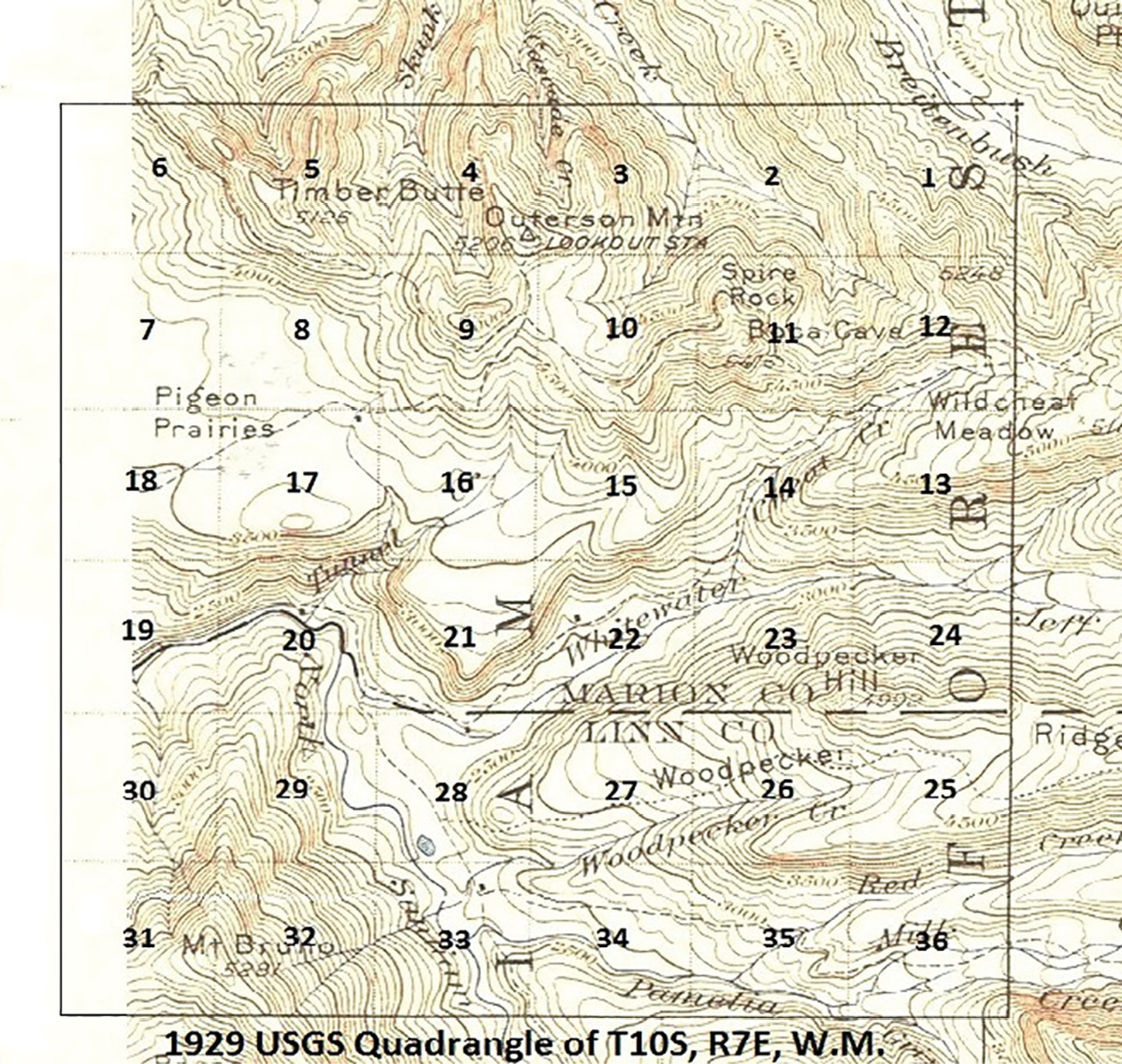
Figure 2
His trail passed through what would later become Sections 20, 28, and 33 of T10S, R7E. In Section 33, there was another existing trail running east along Pamelia Creek, which ran through Sections 33, 34, 35, and 36. If you were to draw a line from the SE corner of T10S, R7E to its NW corner, all the ground to the northeast (18 square miles) was rough, steep, and unexplored. (see Figure 2)
The remaining 18 square miles to the southwest was comparably gentle, with the exception of sections 19, 30, 31, and 32. By the time Bushey reached the NE corner of T10S, R7E, he could see that running the random line west was going to be over very rough and steep terrain. (see Figure 3) The routine GLO instructions were to run the random line West and set temporary corners every 40 chains until the north quarter corner of the “future Section 6” was reached. Then the “deputy surveyor” was to continue on the “random line” west, a half mile and note the distance west and the “falling” at Campbell’s 1891 Township Corner. (see Figure 4 for the overall “scheme)

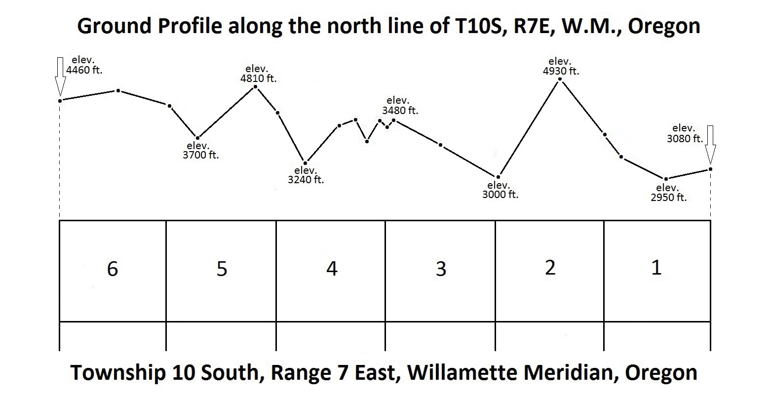
Figure 3
Bushey’s notes on July 25th (see Figure 5) show the last “half mile” to be 76.90 chains. ( the “.90” was crossed out for some reason), but the 76.90 was way out of limits anyway. He also noted the “falling” to be 2.02 chains south of Campbell’s 1891 Township Corner, which makes the True Line bearing to be S 89° 46’ East. On his “true line notes (picture 5) he changes the overall distance for the north line of Section 6 to “79.00 chains” (A survey by a private surveyor in 1968 finds the bearing on the north line of Section 6 to be South 89° 24’ East.)

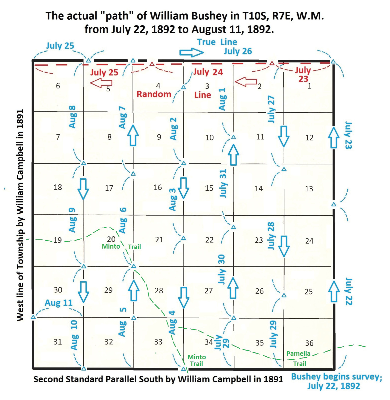
Figure 4
In looking at Bushey’s notes, he did set temporary corners every 40 chains on his random line running west, but in addition, he also recorded all the creek calls, ridge calls etc. for those 6 miles. It appears that he then moved all his random corners north to the true line for the appropriate distances, but left the creek calls, etc. intact for “easting.” Bushey then had to change the chainage for his “true line notes” to conform with “protocol.”

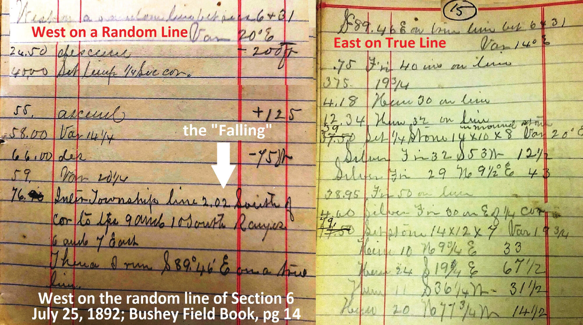
Figure 5
For example, if he made a creek call at 55.20 chains in the random line notes going west, he had to change it to 24.80 chains for his true line notes going east. All he had to do on his “true line” going east was move the random line “temp corners” north the appropriate distances, set a post or stone, and mark some bearing trees. He ran those 5 miles in one day! On July 26th he reached the end of the true line at the northeast corner of Section 1, T10S, R7E which he had set 3 days earlier.
I was expecting the next page to then show him begin subdividing the Township, beginning at the existing corner between Sections 35 and 36. (set by William Campbell in 1891 on the Second Standard Parallel South) To my complete surprise, on July 27th Bushey instead was headed south between Sections 1 and 2! (see Figure 6) (It is obvious that Bushey did not write the field notes that are in the Surveyor General’s records. Bushey’s handwriting is vertical while the GLO notes are slanted and much “neater”)

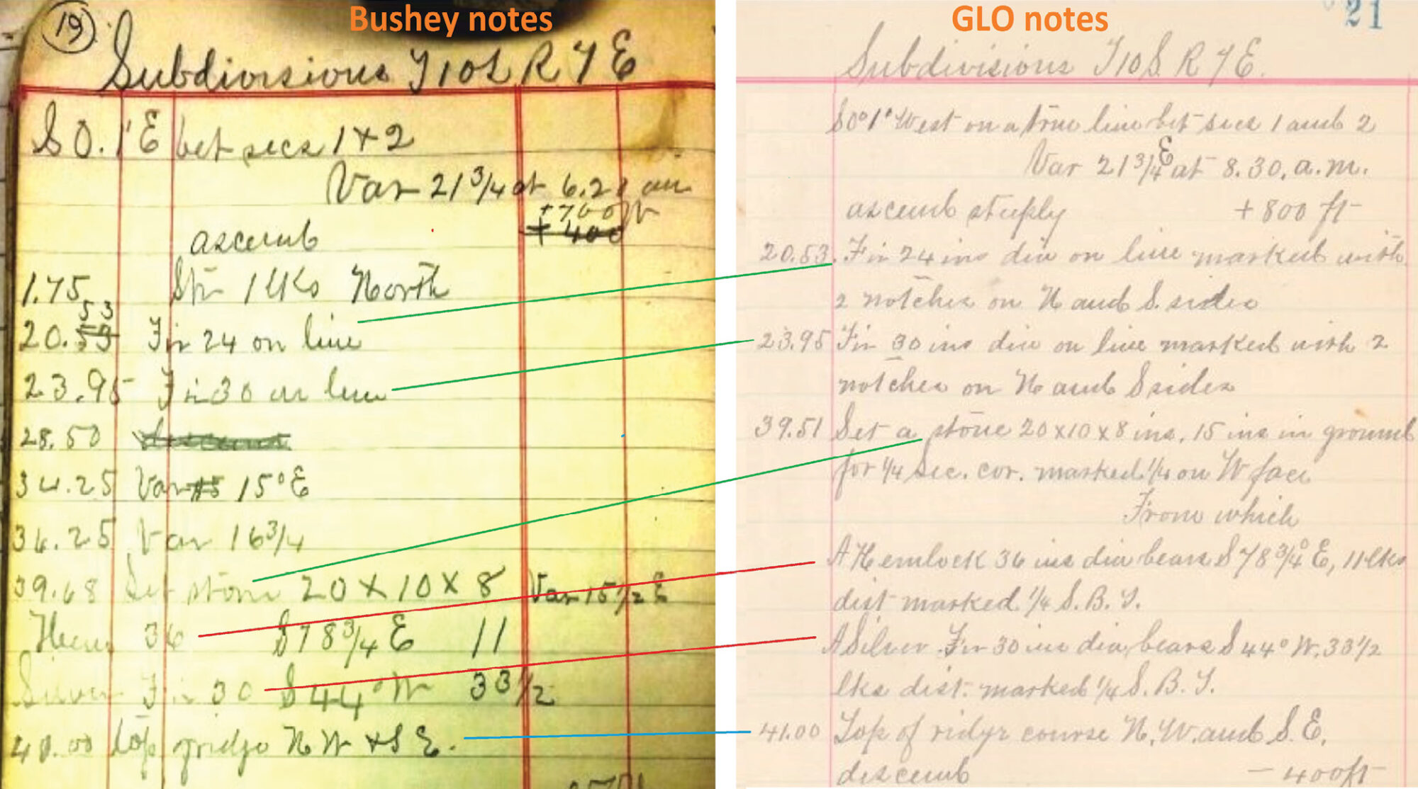
Figure 6
He then proceeded south for 6 miles, setting section and quarter corners, marking BTs, and noting creeks, cliffs, line trees and other normal “calls” till he reached the section corner between Sections 35 and 36 on the south line of the township 3 days later. It was then a fairly level walk going west a mile to Campbell’s 1891 corner between Sections 34 and 35. (Campbell had brushed and surveyed that whole 6 miles the year before, so it was an easy stroll compared to the 6-mile jaunt they had just finished.
Bushey then runs north, making creek calls, etc, and setting the quarter corner between Sections 34 and 35 and then continuing north to set the northwest corner of Section 35. He then runs east on a random line for a mile, closes and notes the “falling” at the northeast corner of Section 35, noting creeks, etc. along the way. He then returns west and sets the quarter corner at the midpoint and marks 2 BTs. Returning to the northwest corner of Section 35, he surveys North again and repeats that scenario for 5 more miles and “closes” on the corner between Sections 2 and 3 on the north Township Line.
His random line between Sections 2 and 3 was N 00° 02’ West, 80.60 chains with his “falling” being 125 links east of the actual corner. This was obviously far out of the limits for closure, which was probably about 50 links. In the “doctored notes” turned in to the GLO, the random line bearing is “North” with the distance being 79.62 chains and the “falling” listed as “40 links west of the corner”.
Bushey and his crew then walk west a mile and start running south on the line between Sections 3 and 4, for 6 miles to “close” on Campbell’s corner for Sections 33 and 34. He also ran east on random lines to close on his prior corners on the way south. Then the crew walks a mile west and starts north again between Sections 32 & 33 for 6 miles as before. This time Bushey’s field book shows his random line running N 00° 03’ W between Sections 4 & 5 for a distance of 81.10 chains and noting that his “falling” is 2.50 chains west of the actual corner! However, his “doctored GLO notes” show the random line to be N 00° 14’ E, 80.18 chains with his “falling” being 37 links West of the corner.
Bushey’s “survey procedure,” while being “illegal,” was obviously very efficient, saving him over 30 miles of “deadheading” if he were to run all the interior lines north and then walk 6 miles back south with all their gear, food, tents, etc. to start north all over again. There were no trails in the “northeast half” of this township so horses couldn’t be used to haul camp gear, etc. Normally in July and August, there are usually 5 or 6 rainy days per month which would make surveying and moving camp even more challenging. That made me start wondering how many other deputy surveyors used similar “tactics” to some degree…? Of course, the “Benson Syndicate” took the idea to a higher level. They had many “surveyors” who didn’t even have to go to the field since they could just made up fictitious survey notes for many of their “surveys” in a tavern.
In 1894, William Bushey was awarded a contract to survey Township 11 South, Range 7 East, the Township just south of T10S, R7E discussed above. He started in 1894, but his “surveys” were not accepted until 1900. (6 years is a bit long to wait for approval and payment) A plethora of situations including communications between Bushey and GLO inspectors, etc, shed further light on his “creative” ways to survey a Township. That, of course, is “another story.” Stay tuned…
C.E.“Chuck” Whitten graduated from Santiam High School in Mill City, OR in 1963. He then went to Oregon State University and graduated in Forest Engineering in 1967 and then was hired by the Washington Department of Natural Resources from 1967 to 1972, working on road location and surveying for timber sales. From 1972 until retirement in 2009, he was a project manager and vice-president for Hagedorn, Inc., a private surveying/engineering firm in Vancouver, WA. Since then, he has enjoyed retracing original GLO surveys. In June, 2021 he was hired by the Marion County Surveyor in Salem, OR to recover section corner evidence in 6 townships devastated by the Beachie Creek and Lionshead Forest Fires of 2020.