The original inhabitants of this land were the Northwestern Band of the Shoshone Tribe. They traveled mainly by foot and later by horse to reach different resources, traveling throughout present-day Utah, Idaho, and Wyoming. The Wahsatch Mountains of Utah in particular, provided important game, seeds, and roots that sustained the Shoshone. The settlements of the surrounding areas, including Echo, were detrimental to the Shoshone’s food systems due to their grazing livestock like sheep and cattle.
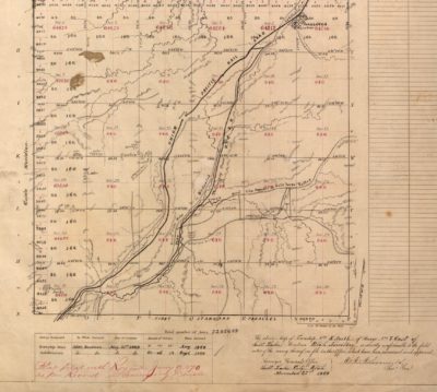
The area seen here now includes Interstate 80, but prior to modern-day highways, it was already an important route for many different people traversing the West, as exemplified by the various roads and railroads listed on this plat.
The “Hastings Cutoff” was opened in 1846 by Lansford W. Hastings as a new cutoff from the California Trail. The first people to use this new route were a group of travelers known as the Harlan-Young Party who, in July of 1846, used it on their way to Salt Lake City. This proved incredibly difficult for them, as the Weber River was nearly impassible. In 1847, Brigham Young led more Mormon immigrants through the Hastings Cutoff, and over the following 20 years, roughly 80,000 Mormon immigrants would travel this route.
The famous Donner-Reed party was the third group of immigrants to make their way through, and the rough terrain just south of here contributed to their misfortunes later on.
Prior to the construction of the railroad, the Pony Express took this same route through this area and into the Echo Canyon to the south. Riders for the Pony Express used the Mormon Trail to get through Echo Canyon and made their way to Salt Lake City. The Pony Express ran for 18 months starting in 1860. It eventually became obsolete with the completion of the transcontinental telegraph and later the transcontinental railroad, which also used this route.
In the Northeast corner of this plat, the surveyor notes the small town of Wahsatch. Today, little remains of the town other than a few foundations and a water tower once used by the railroad. During the construction of the transcontinental railroad, Wahsatch was a temporary home for the workers on the new Union Pacific Railroad.
One of the most notable features along the route here is Castle Rock, as noted in section 31 on the lower left of the survey plat.
Union Pacific “Big Boy” locomotive #4000 in 1941. Association of American Railroads (railroad trade association)/photo by Union Pacific Railroad
Wahsatch sits at the top of the Wahsatch grade. Union Pacific trains heading from Ogden would climb 2501 feet in just 65 miles by the time they reached the summit in Wahsatch at 6,799 feet. To accommodate the equipment needed for this rough terrain, the railroad had maintenance facilities here which can be seen on the survey plat. This only lasted a short time, however, as the harsh winters of this area forced the railroad to move its facilities to the larger town of Evanston, Wyoming in 1871. The grade proved so challenging that the Union Pacific Railroad’s largest locomotives, known as the Big Boys, were sometimes referred to as the “Titans of the Wahsatch.”◾