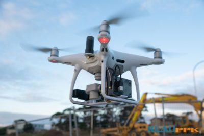
One problem with consumer drone ‘mapping’ systems is that they are light on survey engineering principals. They may capture camera coordinates, but there is no way to know how accurately you are measuring. You need to trust the drone positioning system, without any checks for gross errors, and rely on photogrammetry and GCPs to make it ‘right’.
KlauPPK is a surveying system for drones. Hardware, software, and methodology to provide very highly-reliable and accurate camera coordinates and camera calibration, key to achieving the highest possible accuracy in photogrammetry results.
Beyond this, the system also enables surveyors to make ground survey measurements using their drone. A one-to-one comparison, direct measurements of original survey marks, to know that your drone positioning system is giving you results that agree with your ground survey. This may highlight errors such as datum shifts to a local site coordinate system, or even a wrong base station height measurement. Using the soon to be released phone app, you can even survey ground features as though you were running expensive RTK survey equipment. More information on this coming soon.
With aerial mapping, you need to know that your measurements are accurate as you capture aerial images, before you lean on your photogrammetry software to force the data onto GCPs. At this stage, you may be introducing unknown factors such as camera lens errors or other gross survey errors. These unknowns need to be properly managed in the system.
The traditional alternative of producing data and ‘rubber-sheeting’ it, forcing it to fit a collection of GCPs, is like stretching your measuring tape to get the right answer. It does work, but it is reverse engineering, leaving you with less confidence that the results in between the GCPs are accurate. Plus it takes so much longer in the field and in processing to work this way.
With the forward engineering approach you know your PPK measurements agree with your ground survey coordinate system, then you know that you have a solid blanket of accurate control points in each photo above your site. Now you can isolate camera errors, such as the focal length error (which directly affects model heights) and distortions (which generally deteriorate the data). These parameters can be determined with a camera calibration. A well calibrated, stable camera, with the accurate positional data, will project accurate pixels into a 3D map or model.
Checks are essential to measure how accurate your final product is. With the above process, you will see errors, but they will likely be small and can be isolated and addressed. If you need a couple of GCPs to tweak your camera calibration, then do that, but with the knowledge of what you are doing and why. By understanding the error propagation in the system, surveyors can take a more engineered approach to photogrammetry data capture and processing.
About KlauPPK
Klau Geomatics PPK hardware and post-processing software has been in development for over 6 years and is regarded as the most professional, accurate and reliable solution in the industry. The modular hardware is drone and camera agnostic and can be moved between platforms, enabling the greatest cost effectiveness for fleets of various aircraft. Compatible with manned aircraft, drones from DJI, Intel and other custom drones, and handheld and terrestrial camera systems. KlauPPK Software is the most sophisticated PPK processing software on the market. See full details of the KlauPPK Positioning system at www.KlauPPK.com
About Klau Geomatics
Klau Geomatics is an Australian geospatial innovation company. With its roots in geodetic, mapping and exploration surveying and R&D, Klau Geomatics has a long history at the forefront of technology in the geospatial sector. See www.klauppk.com for product information.