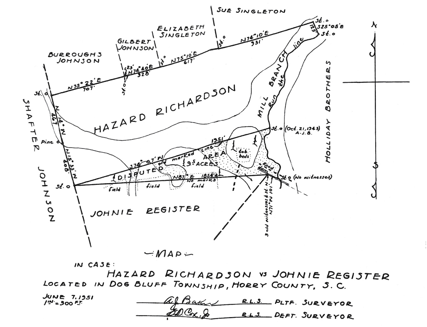
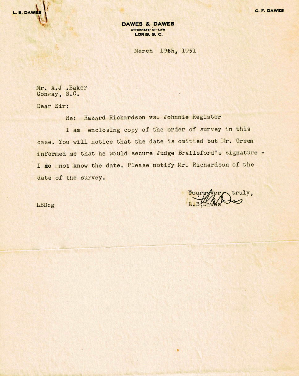
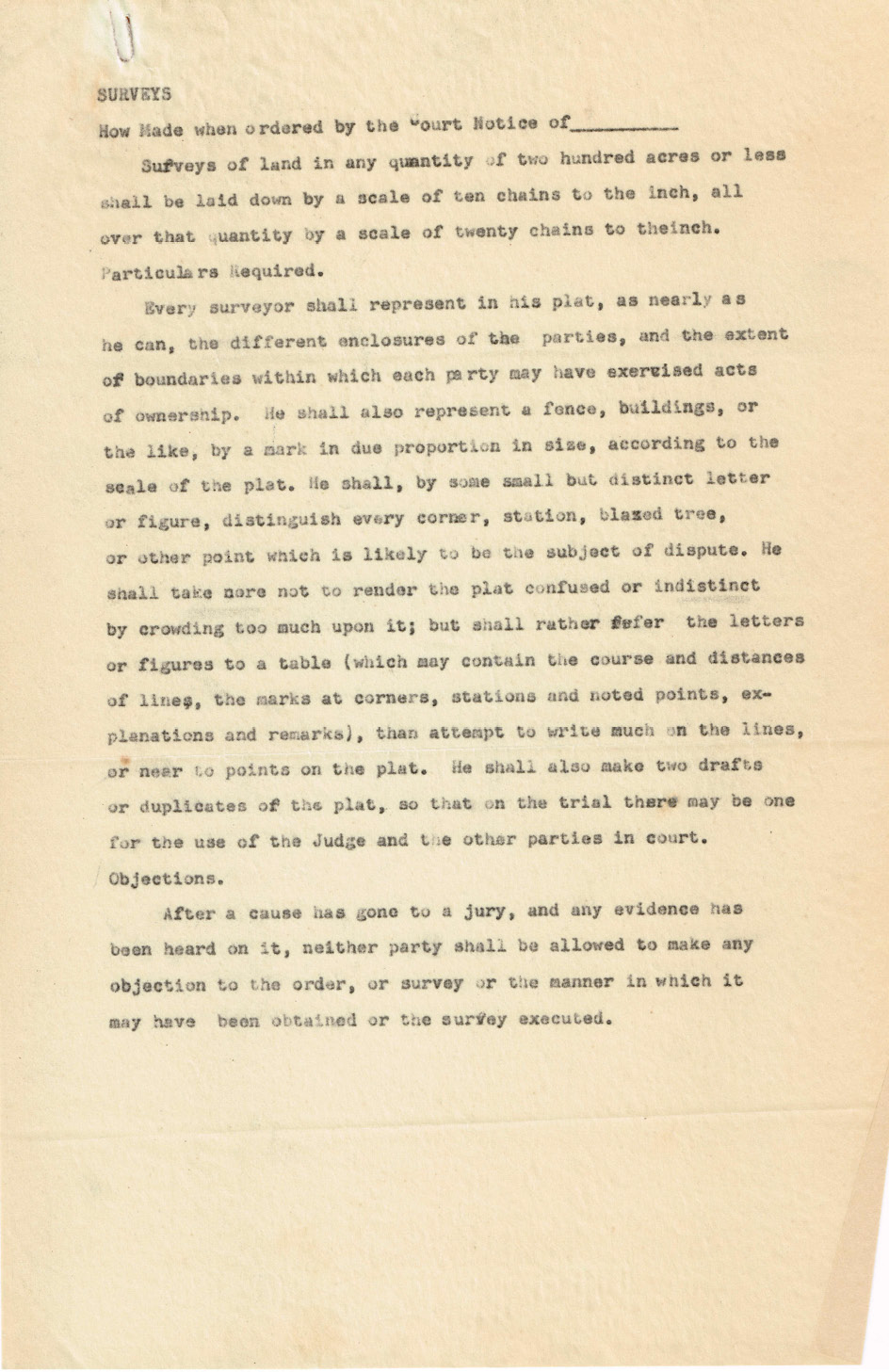
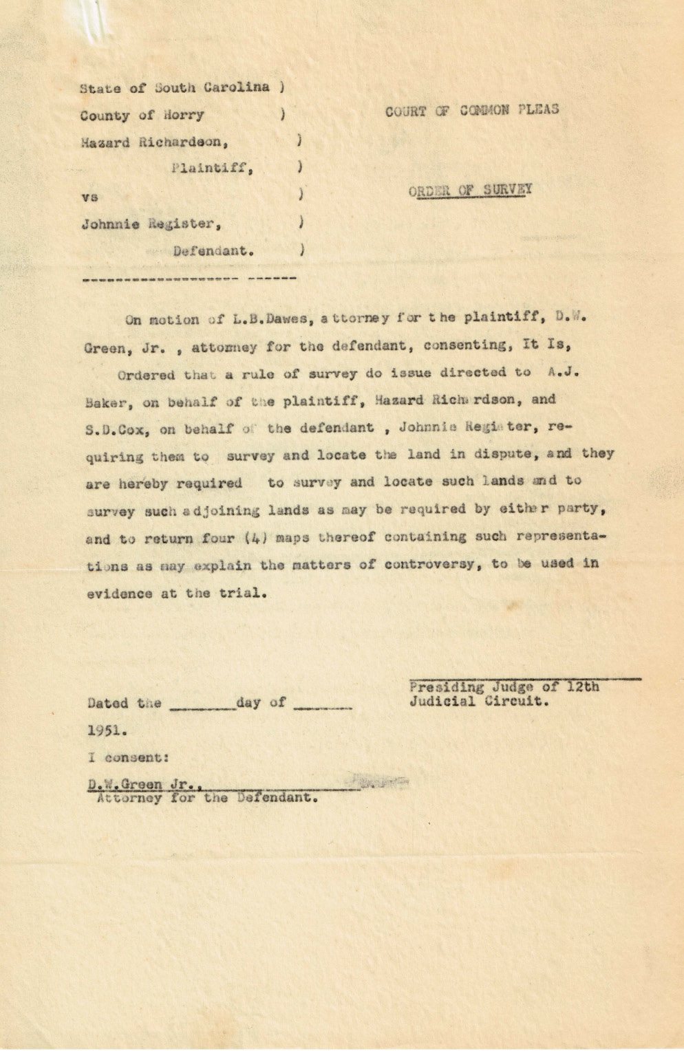
The court ordered a full retracement of Baker’s 1943 conditional survey. The work of the joint survey team revealed the location of the true line. See last month’s issue for the 1943 survey map.
Previously I ran through this decision in my skivvies on a flaming unicycle pedaling clockwise through the roundabout. Last month we dove into the documents that framed the case. It’s time to pull it all together and harvest some knowledge.
Let’s start with the claim. “This action resolved itself into an action to try title to nine and one-half acres, largely woodland, which lies to the south of plaintiff’s admitted acreage, and to the north of the defendant. There is no question of adverse possession. It is really a dispute as to the location of the dividing line of the respective farms of the litigants.” Okay, so the court is fundamentally sorting out the question. Coincidentally, this question is exactly what our mentor Knud E. Hermansen hammers on in his work A Surveyor’s Responsibility and Possession Boundaries. “…where the boundaries are is a question of fact, what are the boundaries is a question of law.” The court easily saw that it needed to grab the shovel and commence to some bob dangling and rope stretching.
The court flushes out the circumstances in the case and boy howdy are they every bit of being circumstantial, subjective, and proprietary. Regardless, these are the facts in the case supported by the evidence. “There was uncertainty of the location of the eastern corner of the southern line of the tract (which is defendant’s northern line) and after plaintiff and Johnson had agreed upon a lump sum price for the land, plaintiff employed a surveyor and he and Johnson accompanied him to make the survey. Also present was one Atkinson who was the employee and representative of the devisees of Holliday who then owned the land to the south, which is now defendant’s. No plat or former deed was available to show the location of the unknown southeastern corner.” So far, so good. The table is racked and the cue ball is set for a true boundary agreement between all of the concerned parties at the time and place of 1943 grant. I emphasize that “no plat or deed had shown the location of the Southeast corner in question” or in other words the parties had a reasonable basis in their belief of ambiguity. This conclave could have put the matter to rest authoritatively right there. The 1943 Baker Survey would have shored up the local cadastre for the owners and future retracement surveyors and life would have gone on. I’m going to emphasize the culprit in this case and nary a rope stretcher will argue this ain’t a two dollar bill under a rattlesnake. “Plaintiff testified, in effect, that because he was in a hurry for a plat, which was necessary in the financing of his purchase, he and Mr. Atkinson agreed that the corner would be located where the latter thought it was, and that later, if found to be incorrect, it would be adjusted.” I’m stuck between labeling this 1.) the most gentlemanly agreement in the history of tenured land rights, or 2.) a drunken Monopoly game between Ray Charles and Yogi Berra.
A court can only work with what it is given. There’s a strong lesson in this case to represent your evidence thoroughly and accurately but without ambiguity. This next bit is not surveying stuff but it really shows how the unexpected might prevail in court. “Atkinson did not testify, nor does the record show that he was subpoenaed. After the conclusion of the evidence and during the argument defendant’s counsel handed up to the court a doctor’s certificate that Mr. Atkinson was sick; but there was no motion for continuance or any effort to procure Mr. Atkinson’s testimony. Therefore plaintiff’s testimony that there was no definite agreement between him and Atkinson upon the location of the line, in which he was corroborated by another witness who was present at the survey, was uncontradicted and the jury were fully justified in accepting it, which their verdict shows they did.” Despite the corroboration this evidence seems a bit one-sided. Maybe there simply was nothing to offset the testimony? Okay, but what about Register’s notice of this conditional boundary agreement? We don’t know what he relied on as grantee but the courts understood his grantor as having notice of the tentative line. That becomes an argument between Register and his predecessor and a different matter in court. We reach another twist with Register’s logic. He’s holding Richardson to the geometry of the Baker survey and not “…the same tract of land which was owned by Annie J. Johnson and then by W.T. Johnson at the time of their deaths and conveyed to the grantor by the other heirs of the said persons.” The focal language in Register’s description is “Bounded as follows: north by lands of Annie J. Johnson…the present boundaries are: north by Hazard Richardson.” The court reinforces the strength of the bounding deed calls in evidence “It is noted that the foregoing description referred to the northern boundary as lands of Annie J. Johnson which was the tract purchased by plaintiff and referred to in the deed to him.”
As a surveyor I’m a little bit salty with Baker’s exclusion of a conditional note on his 1943 survey. Mostly because there’s a secret being incorporated in a document intended to disclose evidence and partially because it led someone to believe something that wasn’t true. Register fell victim to this trap. On the other hand, I admire the Court’s ability to try this case for what it really is: A question of fact and recovery of the ground evidence supporting the true boundary. I’ll defer to the higher court wrap this one for us:
“Defendant’s first contention is that the plaintiff was bound by his plat of 1943, made for the purpose of his purchase, which showed the disputed boundary as claimed by the defendant. But we think that the deed was properly held by the court to be subject to explanation by extrinsic evidence in order to show the intention of the parties. The plat was made a part of the description but the land was also identified as that formerly owned by Annie J. Johnson, which the preponderance of the evidence showed extended to the southern line which was claimed by plaintiff. There was, therefore, a latent ambiguity in the description, which made extrinsic evidence competent.”
Sidebar:
Now let’s explore this concept
The 1943 Baker survey was performed for financing at the request of the lender. Baker fixes a line at 43.8 acres and the parties bind that survey to the conveyance. No doubt a mortgage accompanied the deal based on the conditional work. Here’s the Title Twister question of the month brought you by PW Title Services of Medina, Ohio. How much land is encumbered by a mortgage prepared from Richardson’s legal description?
A. 43.8 Acres per survey requested by lender?
B. 53.3 Acres (43.8 + 9.5) acres recognized by the court?
C. The amount formerly owned by Johnson?
D. Pass, and insure through it?
Feel free to send me your gasbaggings and ramblins on this hypothetical jar of bad kimchee.