“Bounds descriptions are the mark of nobility…‘I own to you and you own to me, there are no gaps or overlaps, and when we are uncertain about our line we will settle the dispute peacefully under law’.”
This is a case where a retracement surveyor just could not have determined a true boundary without firsthand knowledge of an unwritten agreement. It took evidence discovered in the judicial arena to effectively measure this boundary. The Court skillfully employed two local surveyors to reconstruct a boundary line that the owners willfully neglected at the time of the grant. Using the documents provided by Tim Davis we will break this case down to some relevant concepts. For the record I believe the court got this one right.
Richardson’s Chain of title
The Original Legal Description
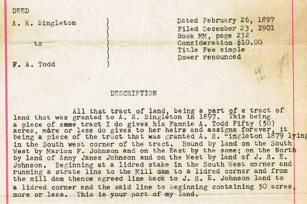
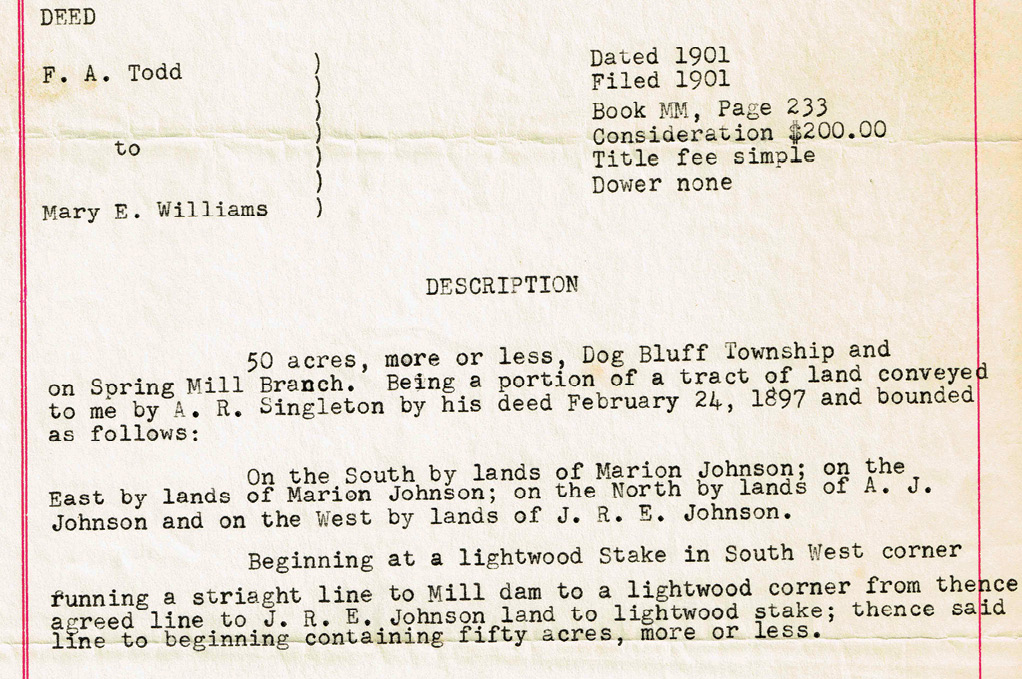
The FSD was executed four years after the original deed and filed immediately after it at page 233. It calls out 50 acres and references the previous deed and split. Four bounding calls are given by cardinal direction. The bounding owners appear to be the same. The linear description also matches the original grant with the exception of the noted monuments. The latter replaces the former term “lidred” with “lightwood”. The grantor was a witness to the recent original grant. All other things being harmonious I don’t see this as much more than a clarification of the monument properties or perhaps they re-staked it. Regardless, the intent of this deed is clear. It is to pass title to the same 50 acres that was given to the grantor four years prior. I had to google “lidred” and found that it means wood used for kindling especially coniferous wood abounding in pitch.
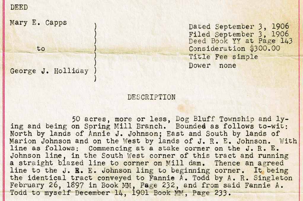
The third grant in this chain of title was dated and filed September 3, 1906 in Book YY page 143. For whatever reason, the third deed in the chain picked up some noise in the legal description. We still see our cardinal bounding calls. However the linear calls in this deed start to degrade from the original verbiage. This doesn’t negate the conveyance nor mean that there is no evidentiary value. Valuable calls to the adjoiners and for a stake, a blazed line, the Mill dam, and the agreed line are identified. Once again the intent is chiseled in stone by the colloquial call “It being the identical tract conveyed to Fannie A. Todd by A.R. Singleton February 26, 1897 in Book MM, Page 232 and from said Fannie A. Todd to myself December 14,1901 Book MM Page 233.” I’m not getting excited about the grantor’s modulation of the linear calls in the presence of her clear intent.
Two World Wars and a Great Depression later
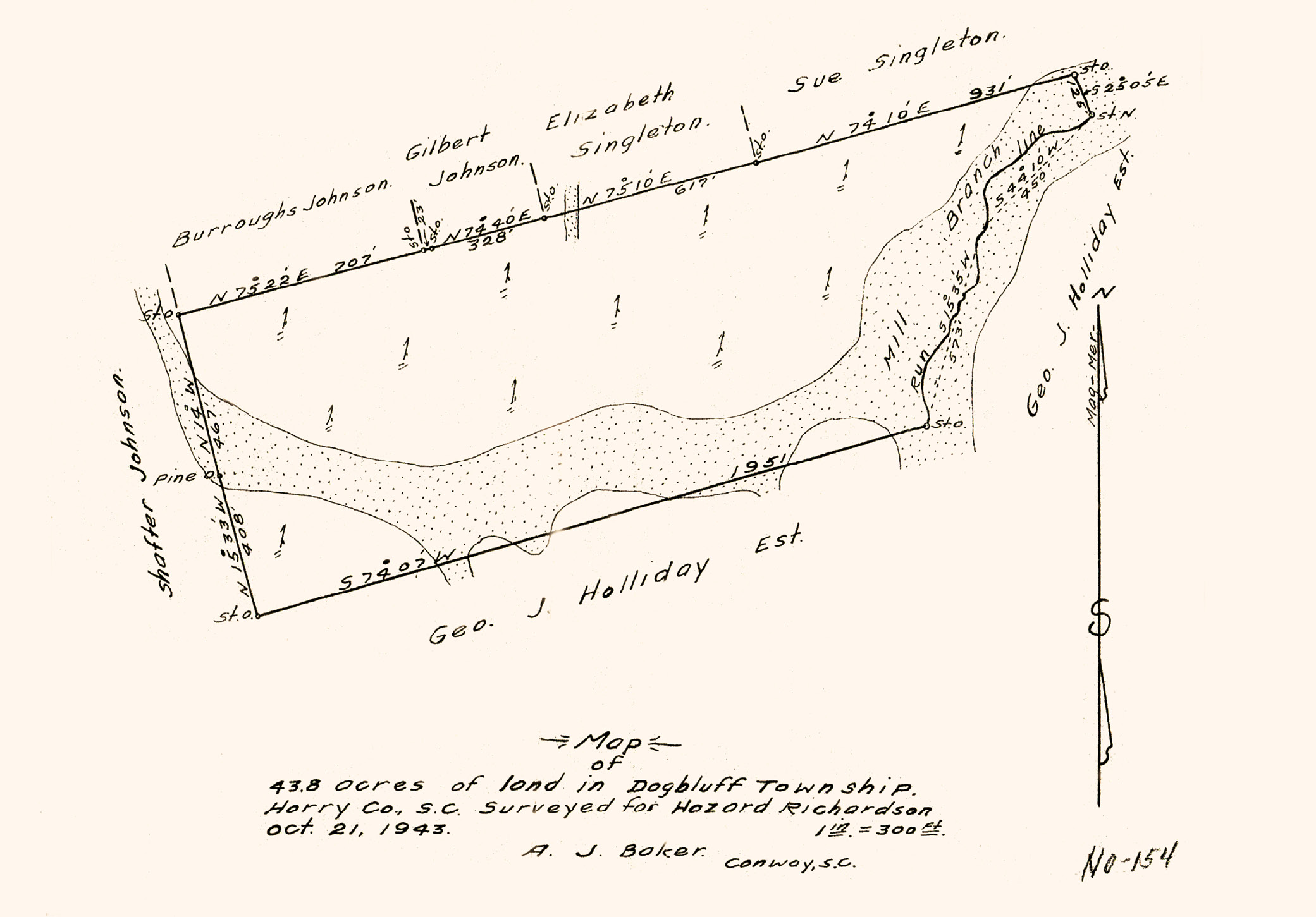
Richardson takes title on November 16, 1943 with the October 21, 1943 Baker survey in hand. The court record recites the description including the customary final call “This is the same tract of land which was owned by Annie J. Johnson and then by W.T. Johnson at the time of their deaths and conveyed to the grantor by the other heirs of the said persons.” Once again this is the intent of the deed. The accompanying survey accurately calls the Geo. Holliday tract to the south but does not reference the tentative agreement. More on that topic later.

The Register grant of the opposing tract was dated October 15, 1947 and filed October 21, 1947. The description stays true to the colloquial form in the previous deeds. However our boundaries and chain of title are mildly distressed by this time. The grantor announces that one acre had been previously sold off leaving 49 acres for this conveyance. There’s a reference to a preceding deed in Book XXX, page 309, that the grantor is instructing us to go get. Once again we see the value of summarizing the intent. The grantor states “Being the identical tract conveyed us by Geo. J. Holliday.” This might point to Book YY Page 143 but we need to approach that assumption with care if not skepticism. Geo. J. Holliday may have owned many tracts. The summary continues on with “One acre at the South West corner having been sold to Townsend Register, the present boundaries are: North by Hazzard Richardson; East by Holliday Brothers (A.R. Singleton lands) South by Townsend Register and West by L.B. Register and Shafter Johnson.”
Pulling it all together
There is a lot of name dropping in bounds descriptions and as we see here different folks shared the same name. How do you sort that mess out? Retracing bounds descriptions can be who’s who game and may require a good deal of title research. That charge comes with the responsibility of examining the baggage of the heirs, successors, assigns as well as the adjoining grants. Extrinsic evidence may be required to get a clear picture of a boundary as well.
All of these grants are presumably legal and happened willfully under the authority of the owners. We have to accept them for what they are. Tim Davis indicated that it was customary to walk the boundaries and agree on the location then have a plat drawn to that agreement. Sometimes the local church deacon would be present to serve as a witness and other times a deed for the corrected line may not have been used. We clearly see in Richardson that the force of a retracement survey made under the direction of the subsequent owners was limited to only as much weight as the owners afforded it. The numbers were not even parlayed to the record but rather relegated to an unauthoritative map of a tentative line and buried in a surveyor’s cabinet. In fact, it’s the first time we see any math or metes of this tract and it’s a half century later plus four conveyances after the original grant.
There’s no doubt in my mind that our rope stretchers on the eastern seaboard and in the Appalachian fringe are masters of retracement if for no other reason than sheer necessity. The newer PLSS states might look eastward at the colonials and the Lone Star State to harvest this experience. I’ve said it before and I’ll say it again. Every day that passes is one day farther away from the Manual of Instruction. As the original PLSS degrades and folks subdivide their land as they see fit, the squares ain’t gonna be so square. The legal descriptions in Richardson v. Register offer strong model language that reinforces intent in the absence of plat math. The lesson is that the legal force and accuracy of a description lies more in its words than its numbers.