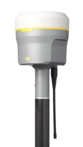
The new enhancements include:
• The latest and most advanced custom Trimble survey GNSS ASIC with an industry-leading 672 GNSS channels for unrivaled GNSS constellation tracking, including GPS, GLONASS, BeiDou, Galileo, QZSS, IRNSS as well as the full range of SBAS. The Trimble R10 Model 2 tracks and processes all of today’s available GNSS signals and is designed to support planned GNSS signals and systems that may be launched in the future.
• Improved reliability against sources of interference and spoofed signals.
• Improved power management to increase battery life and operating time in the field on average by 33 percent.
• Increased internal memory (6 GB) to store more than 10 years of raw observations.
• Support for Android and iOS platforms to allow organizations with Bring Your Own Device (BYOD) environments to benefit from a premium survey GNSS receiver by using the mobile devices their field crews already have in their pockets.
Advanced GNSS Rover System
The Trimble R10 Model 2 supports the recently released Trimble TSC7 controller and Trimble Access™ 2018 field software. The Trimble R10, in combination with the TSC7’s large 7-inch screen and faster processing power plus Trimble Access 2018’s new user interface and graphics capabilities, gives surveyors a superior, comprehensive solution for collecting and computing data in the field.
“These improvements ensure the Trimble R10 remains one of the most current and relevant GNSS survey solutions on the market today,” said Olivier Casabianca, director of global marketing for Trimble Geospatial. “By providing a powerful rover system such as the R10 Model 2, TSC7 controller and Access 2018 field software, Trimble continues its legacy of unmatched GNSS expertise and knowledge to advance the capabilities of surveyors around the world.”
The Trimble R10 Model 2 GNSS System is available now through Trimble’s Geospatial distribution channel. For more information, visit: https://geospatial.trimble.com/products-and-solutions/r10.
About Trimble Geospatial
Trimble Geospatial provides solutions that facilitate high-quality, productive workflows and information exchange, driving value for a global and diverse customer base of surveyors, engineering and GIS service companies, governments, utilities and transportation authorities. Trimble’s innovative technologies include integrated sensors, field applications, real-time communications and office software for processing, modeling and data analytics. Using Trimble solutions, organizations can capture the most accurate spatial data and transform it into intelligence to deliver increased productivity and improved decision-making. Whether enabling more efficient use of natural resources or enhancing the performance and lifecycle of civil infrastructure, timely and reliable geospatial information is at the core of Trimble’s solutions to transform the way work is done. For more information, visit: https://geospatial.trimble.com.
About Trimble
Trimble is transforming the way the world works by delivering products and services that connect the physical and digital worlds. Core technologies in positioning, modeling, connectivity and data analytics enable customers to improve productivity, quality, safety and sustainability. From purpose built products to enterprise lifecycle solutions, Trimble software, hardware and services are transforming industries such as agriculture, construction, geospatial and transportation and logistics. For more information about Trimble (NASDAQ:TRMB), visit: http://www.trimble.com.
