This case is from 1809. It’s a challenge to read because the language is old. It’s not unrealistic to believe the Justices were born before the American Revolution, so the linguistics may sound a bit ancient if not altogether foreign. I’m going to zero in on some things and connect the dots between a couple of centuries of decided guidance. I’m not here to dazzle anyone with my lack of knowledge in the Laws and Customs of the Commonwealths of Virginia and Kentucky. However, I do feel like I have a good enough handle on my craft to draw historic parallels along the bloodline of our professional guidance. Interestingly enough, this case was heard by the U.S. Supreme Court. According to internet lore the Kentucky Supreme Court was created by a 1975 constitutional amendment and is the state supreme court of the U.S. State of Kentucky. Prior to that the Kentucky Court of Appeals was the only appellate court in Kentucky. The Kentucky Court of Appeals is now Kentucky’s intermediate appellate court. This case involves four jurisdictions and Virginia is as good a place to start as any.
Old Dominion offers us the bridge between subjects of a crown and free men. The chains of title in this case were originated under the rule of the English Crown and of course prior to the American Revolution. Kentucky in turn was carved out of Virginia and further respected the rights of these pre-existing grants. Out west we see a similar respect with sovereign grants descending from the Crown of Spanish Royalty (see amerisurv.com/ content/view/6083/136/). There are a few distinguishing features between Colonial land grants and the US Public Domain. Primarily the Colonial Land Grants were created sequentially and the US Public Domain was subdivided in a simultaneous nature. Let’s break this down into simplest terms. In 1796 Thomas Jefferson created the world’s biggest subdivision plat and recorded it downtown. So, there you have it and I’ll file that under American Ingenuity. Jefferson was born a subject of the Crown in Shadwell, Colony of Virginia, British America. He fixed that and died a free man in Monticello, Virginia, United States. Jefferson, The father of the G.L.O. was also a “son” of the Colonial System of Surveys. He was a farmer, an attorney, the son of an accomplished Land Surveyor, and a Surveyor in his own right. I think it’s fair to presume he understood all aspects of property ownership. As the right man in the right place at the right time, Jefferson became the catalyst between the feudal land tenure of European Monarchs and the fee simple title we enjoy today in the United States.
Both parties in this case had a right to land because of their military service to the Crown prior to 1763. McDonald was predecessor to Taylor & Quarles, the plaintiff, and Sumner was the defendant Brown’s predecessor. Here’s the breakdown of events:
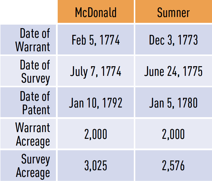
The Court also pointed out that “The quantity covered by both surveys was 1,080 acres, of which Taylor claimed 660 and Quarles 200; it did not appear who claimed the other 220 acres included in the interference.”
Okay, we’ve all had bad days at work and deadlines but Hancock Taylor takes the cake. “McDonald’s survey was made by Hancock Taylor, an assistant surveyor of Fincastle County, where the lands lay, who, before his return to the office, was killed by the Indians on the last of July, 1774, but his field books and papers were preserved by his attendants and delivered to the principal surveyor of the county in September, 1774, who made out a plat therefrom. ” I can tell a story or two about “cray-cray” landowners waving guns but I can honestly say that I have never died at the hand of the hostile indigenous folk. Try explaining that one to OSHA or the workmen’s comp gang. Despite Taylor’s untimely demise the crew made it back in the office with the job file and no doubt engaged some good ol’ shuckin n’ jivin’ down at the tavern afterward. I hope there was a little something extra in their paychecks that Friday for their trouble.
This is an interesting observation “In this case the title of both parties originates in surveys made by the surveyor of Fincastle County…” Things must have looked good on paper if both surveys were reviewed or performed by the same County Surveyor and within a year of each other. This just makes me wonder, nothing more.
So in a nutshell the plaintiff is claiming his survey is senior and thus secures his claim over the defendant’s which is the way it goes unless some mitigating circumstance can be proven. The defendant is attempting to upset this otherwise valid senior survey by demonstrating flaws in the process as follows:
1. The warrant was not in possession of the principal survey or when the survey was made. I suspect that today this would be akin to the BLM field crew leaving their copy of the special instructions at the district office or the private party chief not carrying a copy of the contract/scope of services in the truck. Big whoopee ding, right?
2. The survey does not appear to have been recorded within two months after it was made. Ouch, but not a deal breaker. Today we might find a cap or tag with an I.D. number and contact the knothead who’s tossing lawn darts without laying down paper. Remember, the recording laws are directed at us, not the clients and owners.
3. The survey must be certified by the person who made it, and can be authenticated in no other manner. It was customary for both the field surveyor (assistant) and the principal to sign the plat but that did not happen because, well…ummm…because the poor guy was killed in action! The Court politely recognized the extraneous circumstance and felt the law was met with the principal’s signature. The Court did offer a detailed examination of something that your state board might refer to as “Responsible Charge”. This could be worth an extra peek at your state’s definitions if you are unfamiliar with the details of the concept.
4. The plaintiffs’ negligence (to record or serve notice of the survey). The Court summed this up very neatly. “If the survey of McDonald came within the law, the circumstance that the subsequent survey of Sumner was made without notice in fact cannot alter the case. His warrant only authorized him to acquire vacant land, and he took upon himself to find lands of that description. The principle caveat emptor is directly applicable.”
5. The patent of the plaintiffs contains surplus land. The warrant, it is said, was an authority to survey only 2,000 acres, and for the surplus the survey was made without authority. The Court really exercised this claim. It came up with this answer “It is a fact of universal notoriety in Virginia not only that the old military surveys but that the old patents of that country generally contain a greater quantity of land than the patents call for. The ancient law of Virginia notices this fact and provides for the case. It prescribes the manner in which this surplus may be acquired by other persons, and it is worthy of notice that the patentee must himself reject the surplus before it can be acquired by another, and after having so rejected it, he has the election to allot it in such part of his patent as he pleases.” We have judicial notice that this is legal. Good catch young SCOTUS! It’s further noted that there’s a method to fix this if the senior entryman so desires.
Okay, that was the rundown on the case. The Supreme Court overturned the Kentucky Court of Appeals and ruled in favor of the plaintiff. It’s not hard to see why in hindsight. So our next order of business is to run through the syllabus provided presumably by the Supreme Court. Basically the SCOTUS listed legal concepts associated with this case. Two centuries later I recognized similarities between our daily practices and this old list. I’ll highlight what I am seeing:
1. The first survey, under a military land warrant in Virginia, gives the prior equity. The survey is the act of appropriation. [This sounds an awful lot like senior rights and the survey controls. Is anybody else warm and fuzzy?] The certificate of survey is sufficient evidence that the warrant was in the hands of the surveyors. [I believe the BLM might equate this to the issuance of the instructions.]
2. That clause of the land law of Virginia which requires every survey to be recorded within two months after it is made is merely directory to the surveyor, and his neglect to record it does not invalidate the survey. [Just like “all of the other things that happen with the plat”. Technicalities don’t upset the force of grants. Recording laws among other regulations apply to us as registrants but may not impede the rights of owners to convey and take title.]
3. It is not necessary that the deputy surveyor who made the survey should make out the plat and certify it. It may be done from his notes by the principal surveyor. [They call this “responsible charge” and “direct supervision” down at your Board of Land Surveyors and Engineers.]
4. A subsequent locator of land in Virginia, without notice of the prior location, cannot protect himself by obtaining the elder patent. A survey is not void because it includes more land than was directed to be surveyed by the warrant. [This sounds like two different concepts. The first part seems to clearly respect the first survey and a senior right. The second part feels like a big old heap of “more or less”…without the less. Given that the whole idea was to get folks to settle and develop the new world, it makes plain sense to give extra unclaimed land to the willing in the “vast and unknown wilderness”.]
5. The patent relates to the inception of title, and therefore, in a court of equity, the person who has first appropriated the land has the best title unless his equity is impaired by the circumstances of the case. [Anybody else feeling the senior rights and bona fide rights?]
6. The locator of a warrant undertakes himself to find waste and unappropriated land, and his patent issues upon his own information to the government, and at his own risk. He cannot be considered as a purchaser without notice. [This is awesome as it seems to place the liability in the locator’s hands and sounds like the Crown setup an honor system. Conversely the US PLSS’s function was to eliminate any confusion and perhaps mitigate some risk created through this honor system. Notice how the Government disclaims liability and places it back on the locator. It’s kind of like a contemporary GIS disclaimer, isn’t it?]
7. The equity of the prior locator extends to the surplus land surveyed, as well as to the quantity mentioned in the warrant. [Sounds again like senior rights in both the warrant and the locator’s bona fide claim to unappropriated lands.]
Unlike many contemporary “professions” ours has its foundation in centuries and maybe millennia of law and practice. That becomes apparent by connecting the dots between this old case and our contemporary practices. We can see that this case really isn’t a mano a mano surveyors’ cage match. If I read this correctly the County Surveyor of Fincastle County was responsible for both surveys. The lesson that I take from this case is that we must understand our chains of title. Additionally and on a parallel siding the smaller subdivisions of PLSS may not have been actually staked at the time of the plat or patent. That opens the door for subsequent “original” surveys that carry a senior weight against others much like the Colonial system. Interestingly enough, they may not land square on the ground with the places that Manual of Instruction says “they should have been”.
Well, that about wraps up this Yankee’s pilgrimage into the Old Dominion. The totals for this month’s column are 2 Commonwealths, 2 honorable military discharges, 2 systems of land tenure, 1 monarchy, 1 republic, 1 revolution, 1 casualty, 1 U.S. Supreme Court and 220 unclaimed acres. The Surveyors of this territory garner my highest respect for their rich heritage and requisite understanding of land law. As our beloved PLSS matures we naturally will look to Old Dominion as our elder sibling having “been there and done that” with respect to the long term behavior of chains of title on the ground.
Note: Taylor and Quarles v. Brown can be found at https://amerisurv.com/docs/TaylorAndQuarlesVersusBrown.docx
Sidebar:
The Barbershop Barrister
This month in the Barbershop we’re going to spend some time on similarities when retracing any land system. We also have a public service announcement brought to you by a grant from the Taylor and Quarles v. Brown Corporation for the Humanities in Land Surveying Foundation. “The second objection is that the survey does not appear to have been recorded within two months after it was made.” We are talking about the 1770’s. Plats were drawn by candlelight with big plumey feather quills on paper they had to make themselves, without cad, calculators or data collectors, yet they only had 60 days to record. Arizona and Nevada both appropriate a generous ninety days and up in the thin air of Colorado the registrants get a full year to record. Good time to take a peek at your “to be recorded” pile, eh?
…aaaaand we’re back. After the shine wears off of the brass caps there’s not so much difference in retracing either system except that one is simultaneous and one is sequential…just like barbeque is the same everywhere, right? It’s meat, wood, and fire. Well, wait now, there’s pork vs. beef, shoulder vs. ribs, vinegar or tomato and blah, blah, blah…Okay setting aside local flavor, retracement is about collecting evidence of an original survey. Our colleagues in the colonial states have centuries of experience retracing land grants from sovereigns both foreign and domestic. A retracement survey in the “post disposal” PLSS should look more like a Colonial Retracement than a “bluebook” resurvey of the public lands remaining under Congress. Why? Because we are retracing independent chains of title rather than slicing fresh land under federal ownership. Old T-Jeff’s revolutionary simultaneous conveyance simplifies the original subdivision process for disposal and federal retracement while under Congressional Authority but once the cake is served it’s too late to recut it. A private domain retracement should attempt to include the compilation and thorough examination of original field notes, the plat, the patent, and a chain of title among other things. However, be realistic and understand that a lot retracement in a regulated modern subdivision may not require much attention backward beyond the plat. Regardless, retracing in any system is about where the corner fell rather than where it was supposed to fall. Wood v. Mandrilla (The American Surveyor, Decided Guidance, October 2016, http://www.amerisurv. com/content/view/15484/153/) demonstrates that the Federal schematics may very well not apply where aliquot portions were not monumented or specifically expressed in the patent. When it comes to retracement surveying, I additionally look to our colonial brethren’s standard of care for two reasons. 1.) They don’t have a false sense of security or “easy out” by offering the BLM’s proportion method as a substitute for evidence, and 2.) Colonial land grants have been enriched and fortified by the hands of the subsequent authority vested in the chainees of title. The behavior we see in a Virginian chain of title today is still in the future for the PLSS saplings like Arizona and Alaska. In fact, there are original patentees in my Arizona County and they’re “alive n’ kickin”. I suspect in the Colonies that an original patentee is more synonymous with great-greatgreat-great grandpap’ than your living neighbor. Anyway, as the PLSS patent locations ripen through respectful chains of title, think “stability of boundaries” and “perpetuation of evidence” as the first resort. Considering that PLSS patentees were normally on their own to subdivide sections, it stands to reason that subsequent corners did land inconsistently against the schematics found in “The Manual”. It is a reality that when you go into a section you may be facing many subsequent original or “first” surveys by different surveyors done at different times. Add roads, fences, ditches, structures, etc, and the noise factor surrounding original evidence increases as the needle starts to dip toward a Colonial scenario. I assure you however that the evidence is in the record and on the ground, albeit not always square.