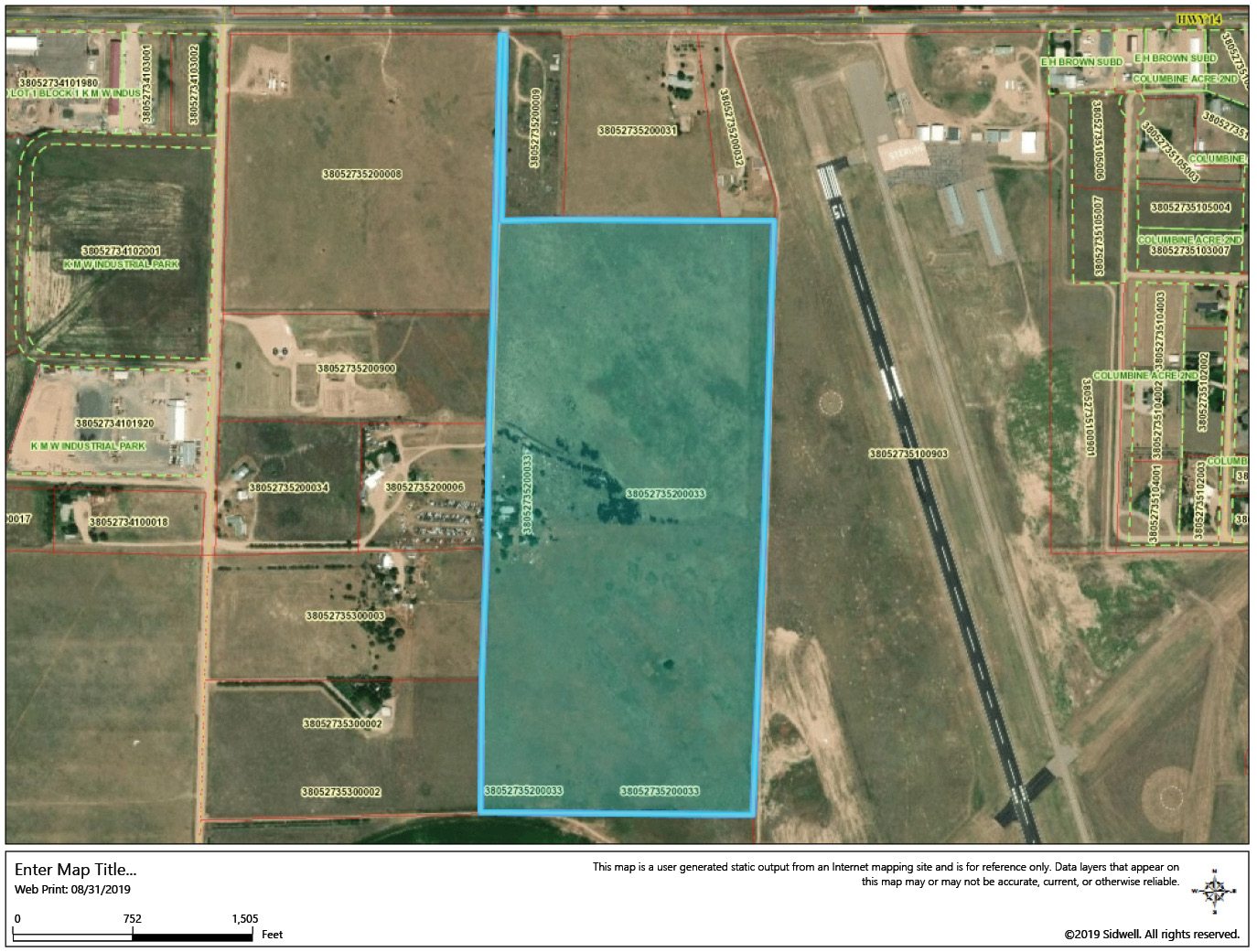
Current owners are listed as Gaines (blue) and the City of Sterling (airport). As expected the PLSS is a little bit cockeyed and not perfectly cardinal after a few generations.
This month’s case is a real humdinger from the Centennial State. Colorado is of course a PLSS state littered with mining claims. There’s also riparian meandering issues along the lower Arkansas, Spanish Land Grants south of the Arkansas, Homestead Entry Surveys and even a few hills and hollers bending the squares on old T-Jeff’s 6th Principal checkerboard. Sterling is a remote farm community way out on the northeastern plains where even the antelope don’t know if they should route for the Broncos or the Chiefs. Unbeknownst to me there’s some “Torrenized” land out there. This case is an appeal by Gaines who is referred to as “Plaintiff in error” which is synonymous with appellant. We’re going to break this case down hard so hang on kids because it’s a crazy ride full of robes stretching ropes and a bob dangler dangling his dangle bob where he shouldn’t have dangled diddley.
The court rolls out the red carpet by laying down some evidence. “…prior to the acquisition of their respective properties by plaintiffs and defendant both tracts of land were in one common ownership and while so owned in the year 1919 were registered along with other lands under the Torrens Title Registration Act.” Once again the court establishes the common grantor right off the bat. We’ve seen this time and time again throughout our case studies. Despite all of the courts’ deeply established standard of care to establish the common grantor, I have yet to see any state incorporate an examination of title back to the common grantor in their surveying minimum standards…and you wonder how Johnny Deedstaker keeps his license? Fffffffttttt!!! Okay, back on track. We have a bit of a twist here. The Torrens Title Registration Act comes into play but the court quickly established inapplicability to the case. The court kicks this whole thing off with the 1st Commandment of the land surveyor’s authority. “We point out that while construction of plaintiffs’ deed and its legal effect are questions of law, the location of a boundary line is usually a question of fact…” I’m reiterating this for the gazillionth time in The American Surveyor and the kazillionth time for you Brown, Robillard, and Wilson subscribers. All of you Lucaspaloozers, Knudsters, Broadusians are far more than aware of the concept as well. Okay, we’re all on board and know the difference, right? Well, the court decoupled the legalities of Torrens from the facts of location in this boundary dispute and kept the show on the road. “…thus the Torrens Act can have no application to the settlement of a boundary dispute arising after registration of title whether between two registered owners or a Torrens holder and a non-registered owner. This, of course, would not be true if the boundary question had first been raised in the proceedings to register the title for it could be properly determined at that time too. See Balzer v. Pyles, 1932, 350 Ill. 344, 183 N.E. 215.”
Okay, we got the lawyerin’ out of the way so let’s watch as the court pulls on its boots and picks up the ropes. The court establishes some context with this “…Section 35 is one of those parcels of land which is not standard in size, and that all original four section corners, as well as the original quarter section corners in question, had been obliterated, and at the time of suit were unmarked as to the original government survey. This does not mean that the section corners were “lost” corners, however, in the sense that they could not be relocated with some degree of accuracy by recognized natural or permanent monuments, or even by re-survey from township lines some miles away.” Okay, the robes deem these corners as obliterated so this is a retracement job and not the double bubbling of a lost corner.
I’m going to fast forward right to the bad scenes (FYI: the Commissioner is court appointed surveyor) “…the (lower) court held that the Commissioner’s report more nearly coincided with the original government survey than the two surveys of plaintiffs…” That sounds promising, right? Here’s what he did “The record discloses that the Commissioner appointed by the trial court proceeded to the nearest original governmental markers located some three miles away and then surveyed in to what he determined to be the north quarter corner of section 35. He then correlated this with an old irrigation filing and other monuments, including some grown over road ruts in the south half of section 35, to arrive at what he concluded was the original dividing line between the two properties in question.” That sounds like some diligent retracement surveying from my perch, especially in lieu of original existing monuments. Well, the girdle hit the floor and so did everything else. While the Commissioner’s Plat of Pertinent Survey Data To Divide The W ½ From The E ½ Sec. 35 T 8 N R 53 W 6 P M. was admitted and favored by the lower court, the Supreme Court took a tone with him and asserted “The surveyor’s certificate thereon is replete with such unacceptable wording as “* * * As shown above by superimposing a theoretical section from the returned government distances from the east side of the Township we find such a section as respects the line in question does intercept the old line and that fence which was probably on the west side of an old road did start and continue north for a half mile very nearly on such a line. At that time in all probability, the fence was continued north from the end of the road and necessarily would have deflected to the east if it was established at a corner***.” There’s an awful lot of self-righteous “maybe-isms” and conjecture in those words. I’ve seen my share of star spangled babble on surveys and it rarely does any good. According to the court here’s why,
- “The theoretical reconstruction of the original government survey of the north-south center section line, with reference to the old fence line, has no application to this dispute, there being no evidence that the so-called old fence was established as a boundary line or agreed upon or accepted as such by these parties or by their predecessors prior to the registered owner.” These next two statements are compiled out of sequence but relevant nonetheless.
- ”(The Commissioner’s plat) showed a final division of the section (and we note that none of the other owners of the section were parties to this action)…Thus the disparity between the amount awarded plaintiffs as against that given to defendant could also result in a disturbance of other long established land titles in section 35.”
- “Commissioner appointed by the trial court was in error in proceeding upon the theory that the property line in dispute should be based upon his theoretical reconstruction of the original government survey of the center line of section 35. This error is further magnified when the evidence discloses, as it did here, that all three surveyors agreed (and there was no evidence to the contrary) that the original government survey called for equal subdivisions within the section.”
Now this is where things get narrow. The court deemed the corners as obliterated rather than lost, right? And I quote “The evidence discloses that Section 35 is one of those parcels of land which is not standard in size, and that all original four section corners, as well as the original quarter section corners in question, had been obliterated, and at the time of suit were unmarked as to the original government survey. This does not mean that the section corners were “lost” corners, however, in the sense that they could not be relocated with some degree of accuracy by recognized natural or permanent monuments, or even by re-survey from township lines some miles away.” The court is operating in the era of the 1947 Manual of Instructions (1947) and appropriately adopted 1947 as the standard. A perusal of 1947 reveals some very rigid standards for obliterated and lost corners. 1947 also calls out some standards for collateral evidence and testimony. The bottom line for the court is that any evidence has to be directly tied to the original location it’s purporting to represent. Unfortunately the old adage of “the large print giveth, and the fine print taketh away” held true in the Supreme Court’s eyes and torched the credibility of the Commissioner’s survey like a doobie at a Dead Concert. The terms “probably” and “in all probability” are certainly not evidence of an original corner. The court sure as hell didn’t appreciate the sentiment in a certification. Apparently the “old irrigation filing” lacked relevance or authority despite its potential as positive collateral evidence. The Supreme Court was concerned about the disturbance of other long established land titles in section 35. This leads me to believe that the monuments correlated by the commissioner’s survey may have lacked an authoritative pedigree. Lastly, the old ruts and roadway need some authoritative support. The preponderance of evidence is reinforced by intention, public notice, and deliberate use. For example, a blanket easement over “all section lines as public roads” is a pretty flimsy tie between ruts and an original GLO corner. A stronger bit of evidence might be a county highway declaration calling out the north/south centerline of Section 35 as a public road and then some indication of sustained use and maintenance. Unfortunately and without some stronger and authoritative correlation a set of ruts may only amount to a good time in a 4×4 on a Sunday afternoon. Granted, in 1950 the Commissioner may have been looking at historic wagon ruts; nonetheless they are still just unauthoritative ruts. So the long and short of this case is that the court found no other evidence that would give pause to us falling back on the plat, notes, and manual as the best evidence to replace the obliterated corner. As an aside, a quick peek at the SEARCH GLO RECORDS website reveals a few curve balls with a resurveyed correction line at the bottom of our section and the locals know that the sand of eastern Colorado swallowed up the 6th P.M. survey long ago. Regardless, the evidence shows “…two surveys also prepared by registered professional engineers and land surveyors. Both of these surveyors proceeded to locate the lost corners of section 35 and then applied the rule of single apportionment within the section. This arrived at a north-south line that is the approximate line where the new or easternmost fence is now located, and equally divided the north half of the section from north to south.” And finally here’s why the court duct taped this thing back together using record info “…all three surveyors agreed (and there was no evidence to the contrary) that the original government survey called for equal subdivisions within the section.”
So along with our decided guidance that speculative statements and conjecture are garbage, and that a few of us needed to google “Torrens land” for grins and giggles, the original field notes reveal a true historic precedent. Buffalo bones were buried as a memorial all along the correction line below section 35. Colorado may rue the day that someone digs up two piles of Tatanka pickins a half mile apart along that 2nd Correction Line of T-Jeff’s 6th iteration of squares. Check out the notes on the BLM website and as always feel free to contact me at rls43185@gmail.com.