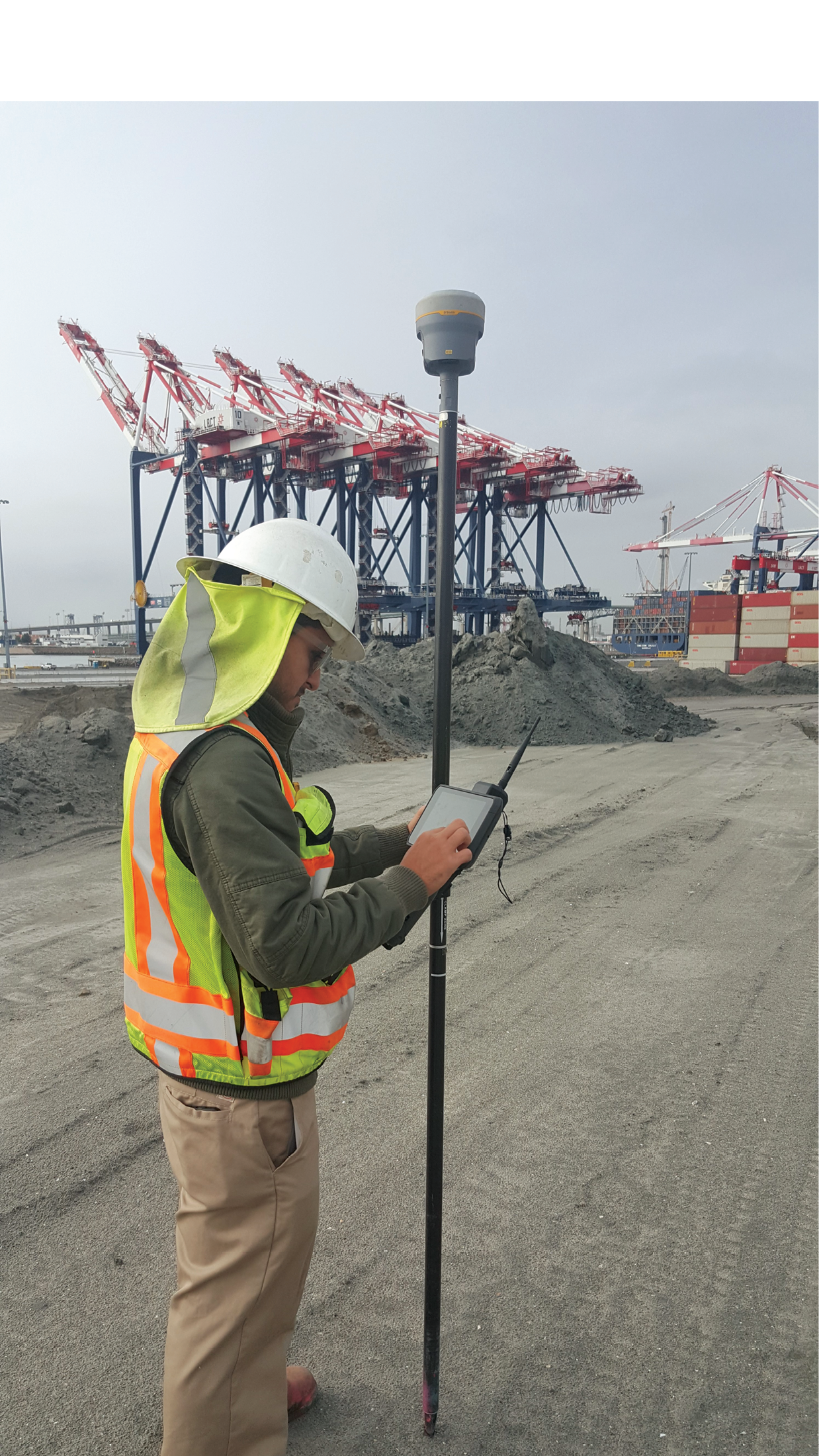
German Esparza Lopez staking grades for pier expansion inside the Port of Long Beach operational zone.
They say that the largest living organism is an Aspen tree grove in Utah. I don’t think “they” have ever had backstage passes to the greatest municipal orchestration known to humankind. When you figure in the cargo ships, the port cranes, the federal highway system, the Alameda railroad corridor, the civil infrastructure, tourism, the petroleum industry, several active fault lines, marine habitat, and the L.A. River, well then, Long Beach, California, may just be the most dynamic integration of humankind on the continent. Within this colossal hub of international commerce, tectonics, and oceanography there is a real-time network pumping out precise data 24/7/365 preserving the health, welfare, and safety of both the public and good old mother earth. I had the esteemed pleasure of spending the day with the masterminds that run the geospatial control system in this epicenter of global activity.
Director of Survey for Port of Long Beach Kimberley Holtz, PLS, PG, Geodesist, and Geologist for the Long Beach Energy Resources Department is the champion of the Long Beach digital measuring network. As a native Long Beacher she melded her community passion with her long-standing professional relationships to pull together the Long Beach Energy Resources Department, Long Beach Public Works, and the Port of Long Beach Survey Department. Leveraging Trimble’s Network Management Services, she cheated the grim reaper of connectivity that seems to lurk within the dark recesses of every IT department. She and the team found a clean way to license external users at her discretion using the Trimble PIVOT platform. Most importantly, the local IT Directors can rest easy knowing that their security measures are fully maintained in this rather innovative approach to accessibility.
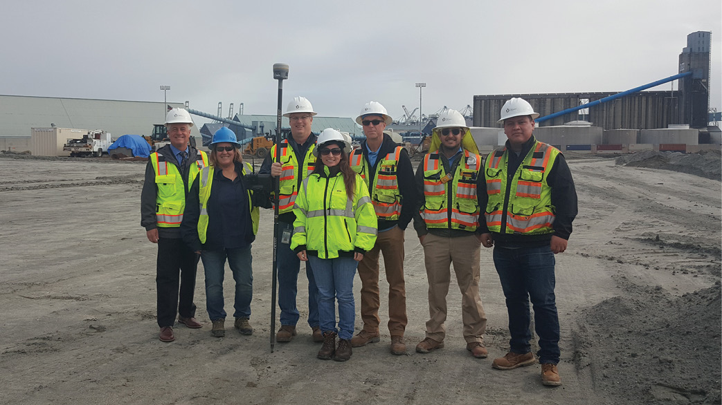
The Long Beach team. (From left: John Hornecker, Kimberley Holtz, Gary Newkirk, Taleah Quemada, Scott McDermid, German Esparza Lopez, Ricardo Garcia de Jesus)
The Long Beach community has a proprietary focus on monitoring the tectonic movement of the base stations, which can be done securely by staff working inside the IT folk’s firewall. Reaping the big dividends of an RTN and providing correction data to the community, however, is a different story. The initial wisdom was that a cellularly connected rover would access correction data through a firewall that is ironically put in place to restrict a random IP address from “pinging” into the system. A year and a half of collaboration between the City, the Port, and Trimble reaped no viable solution enabling a remote IP to securely grab RTN correction data through the firewall. The team toyed with a concept of moving the PIVOT software outside of the City’s firewall. That became unviable with the challenges created by uploading post processing data back through the firewall. Hamstrung by conventional wisdom, the team introduced a new philosophy that turns a firewall into a dual facing mirror. Rather than working through the firewall, Trimble offered a Network Management Service that simultaneously works on both sides of a firewall. I believe they may have just scored a touchdown and set the stage for a seamless nationwide RTN correction service that provides a solution tailored to preserving the local agencies’ security measures. That’s huge considering that there are 3,144 counties and 19,354 cities in the United States where each one no doubt has its unique IT firewalls and security nuances. Think about that for a moment.
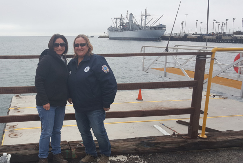
Taleah Quemada, PLS (left) and Kimberley Holtz, PLS, PG (right) stand next to Tidal Benchmark 8, a mere 14 feet above the mean low low waterline of the Pacific Ocean.
The City and Trimble began streaming vendor hosted virtual reference station (VRS) network data in November 2017. Access to the Long Beach Energy Resources Department’s 14 base station network was granted to Public Works and the Port of Long Beach Survey Division. A user agreement is a simple “who, why, and here’s how” form that is renewable on an annual basis. The user licenses are managed by the Energy Resources Department with their “in house” copy of the Trimble PIVOT platform (Trimble’s RTN/VRS software) running under the security of the local firewall. Trimble concurrently runs the PIVOT VRS network software and streams the data to licensed public users outside of the local firewall. Working in tandem around the firewall allows both the city and Trimble to monitor and manage the system for and among other things, data quality and user statistics. While Trimble assumes the burden of all systems and operational troubleshooting, the city provides the labor when replacing hardware. That’s a great arrangement especially to any cash strapped local agency. Additionally, Trimble’s servers can be accessed from just about anywhere, which adds a larger degree of freedom than working in the confines of a municipal Intranet.
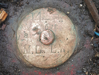
Tidal BM 8 is the mother of all vertical control in the NGVD 29 network controlling the Long Beach VRS.
The Team
The surveying team at Long Beach is a well-oiled cooperative that is staking and shaking through every tectonic ripple this old crusty rock regurgitates. The stability of the VRS Network provides the team with consistent results as they keep the port operations rolling along. Kimberley Holtz is the wizard behind the curtain of Long Beach’s success. She is a model of leadership and can back it up with genuine knowledge in dirt surveying, geodesy, and geology. Kim earned her B.S. in Geology from Cal State Long Beach. When the proverbial bull needs to be grabbed by the horns, Kim is the kind of leader that runs in with a lariat and walks out with a half dozen T-bones and a double cheeseburger. Yeah, she’s that good! She even once demanded that a ship back out of a dock because it was blocking her line of sight. Who pulls that off, right? Kim has been an integral part of the City and Port of Long Beach scenery for her entire life. Her roots run deep in Long Beach following her father, David Holtz who was deputy harbor engineer, and her uncle, Robert Holtz who was a construction inspector for Energy Resources. She is well invested in her community and the good folks of Long Beach couldn’t have been blessed with a finer surveyor!
The City of Long Beach network covers about a township and a half.
Right on Kim’s heels is another brilliant surveyor, Taleah Quemada, PLS She is also a hometown success having grown up in Seal Beach, which shares the coastline adjoining Long Beach. Taleah holds a bachelor’s degree in geography and a minor in geology from the University of Hawaii. She was introduced to surveying while in Hawaii and formed a career path around the profession. Although I don’t quite picture her shimmying up a mooring line to tell a ship captain that he needs to move his hooptie back out of the way, I do see her as more of a forward thinker preemptively coordinating with the harbormaster to keep the line of sight clear before the conflict happens. Taleah is the contemporary answer to those concerned with attracting youth into our profession. She chose surveying over a multitude of appealing career paths that she could have otherwise followed with her degree. The citizens of Long Beach are in good hands with Taleah at the helm of their VRS.
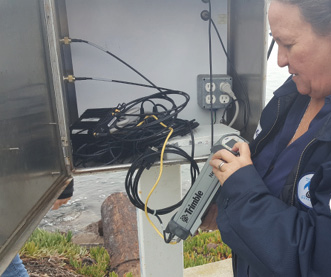
Kim demonstrates the accessibility of the existing NetR9 base in an outdoor enclosure. These Trimble NetR9s have withstood a pummeling from the corrosive salts of the seawater with zero environmental issues.
The Network
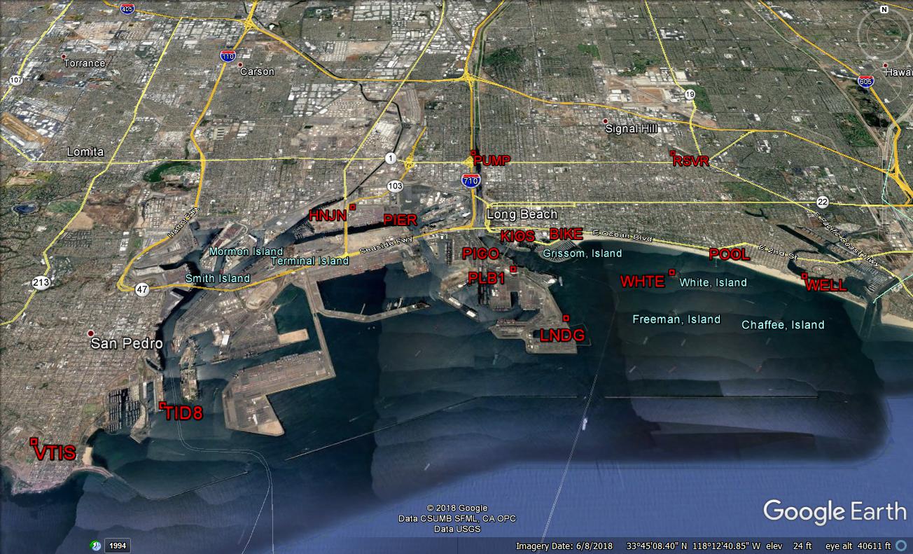
At the heart of this network is a tidal benchmark stamped “8__14. FT. ABOVE M.L.L.W.” It’s pretty simple to interpret this as tidal benchmark number 8 which is 14 feet above the mean low low water line. I humbly submit to you that this is the mother of all elevations across the continent. Don’t believe me? Case in point, the old Denver, Colorado, Mile High stadium was 5,266 feet above Tidal B.M. 8. Get it now? Yeah, this mark is “that” important. The actual VRS network is made up of 14 Trimble NetR9 Global Navigation Satellite System (GNSS) base stations. The construction of the stations is mixed between building fixtures and standalone cabinets along the shoreline. These include solar powered stations where hardwire utilities are impractical. The Trimble NetR9 base stations were installed over eight years ago and have proven to be very durable in the corrosive sea air around the port. Holtz indicated that planned year 2020 upgrades will allow the team to leverage the benefits of the current Trimble Alloy GNSS receivers. The rugged IP68 housing and on-board Wi-Fi should be real game changers in the saline confines of the remote solar cabinets. The geometry of the network might best be described as tight and evenly dispersed. Traditional land surveying accuracies are easily achieved with this robust local network. Considering that the city is surfing the coastline and resting on a big crack in the earth, the folks at Long Beach are concerned with monitoring geological movement caused by seismic activity. The precise monitoring of station data is extremely important to all of the local stakeholders and a large focus of Kim’s expertise as a geodesist and geologist. The physical stability of this network far exceeds the needs of the average rope stretcher because the network serves the higher cause of detecting the crustal motion of the earth. Every millimeter matters when you live on an active fault line a few feet above the water. Especially when the rest of the country is depending on you to deliver 82.3 million metric tons of goods to them every year.
Closing
The topic of attracting the next generation into the survey profession seems to promote a mild anxiety within the contemporary land surveying arena. The City of Long Beach and Trimble are putting those concerns to rest very quickly. The Long Beach VRS network is the heart of many promising careers within the future of our profession. Both Long Beach and Trimble are providing public and private sector opportunities that are truly appealing to college graduates and emerging professionals. The very same technology that forecast our extinction is ironically proving to create more career opportunities through its evolution. The crew down at Long Beach represents the bright future of the promising career paths emerging in our profession.
Sean Fernandez, State Cadastral Surveyor of Utah, smiles as he recalls the evolution of GPS, GNSS, and the VRS network through a chronicle of receivers currently headlined by the Trimble Alloy GNSS Reference Receiver.
Sidebar:
TURN
Long Beach is a small community encompassing 51.5 square miles, or about a township and a half worth of dirt. I mentioned the largest living aspen grove in Utah, which in reality only covers a little over 100 acres. Well, don’t let that fool you. The Beehive State operates a VRS network about the size of modern-day Germany. The Utah Reference Network (TURN) blankets an area of roughly 136,583 square miles! It covers the whole State of Utah, spilling over into neighboring states, Arizona, Colorado, Idaho, and via Nevada, it fringes southern California just a mere 200 crow miles from the docks at Long Beach. How do you feed such a beast? I checked in with Sean Fernandez, State Cadastral Surveyor of Utah, to see how he fuels his baby. His system includes 97 CORS, of which the “in state” stations were originally funded through the legislature. The network was vastly expanded through cooperatives with the adjoining VRS stakeholders. In somewhat of a contrast with Long Beach’s proprietary funding mechanisms and monitoring function, user accessibility is the primary motive behind TURN. Subscriptions are offered to just about anyone who wants to monitor, measure, or move dirt. The $600 annual user subscription fees now sustain the operational costs, 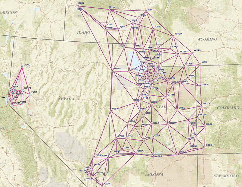 maintenance, and updates to the network. There are approximately 550 users of the system which are a combination of partners and paying customers that connect to the network for a variety of geospatial activities. Fernandez underscored the importance of reinvesting the fees back into the system and maintaining a technologic edge to increase the user experience. The latest addition to the system was the purchase of five Trimble Alloy GNSS Reference Receivers. Given the durability of the Trimble Net R9’s observed in the corrosive salty sea air of Long Beach, I asked Fernandez what enhancements were offered by upgrading to Alloy. From an operations standpoint Fernandez commented, “The Alloy is housed in a durable metallic housing with a large angled display that is easy to read in any environment.” In addition to increased memory, the user interface includes “better buttons that illuminate when pushed and easy access to twin swappable batteries.” Fernandez indicated that the connection points are much easier to access through two Lemo jacks and two serial ports that are spread out across the back of the Alloy. Concerning the user’s return on investment and dividends, Fernandez emphatically replied, “This is the big one, no more firmware agreement required for firmware updates. All firmware updates for the Alloy are free!!!”
A PDF of this article (with more images) can be found HERE