“When my son died, I leaned hard on my passion for land surveying, my positivity, and my search for purpose. The opportunity to own a thriving company like Darling was that purpose for me.” —Amanda J. Manos, PLS
When Amanda J. Manos purchased geospatial services company Darling Geomatics in the fall of 2025, it looked like a seemingly normal business story of entrepreneurship. For Manos, however, the transaction was a moment of bittersweet renewal, one shaped as much by grief as by grit.
In the process of acquiring the company, her young son died unexpectedly — her second profound loss after the death of her husband only two years prior. Suddenly, professional decisions felt both urgent and unimportant at the same time. Unsure of how to move forward as her life was breaking, she sought her son’s council before he passed. She asked him, What would you do about Darling? His answer was immediate and unwavering. Work for yourself, he told her. Build something on your own terms. That clarity, offered so innocently and so firmly, became an anchor when everything else felt unmoored.
“Tragic things happen to people,” says Manos. “I’m not alone in this. But mourning can trap you in a deep hole. Grieving allows movement, purpose, and even growth. So just as I did when I lost my husband, when my son died I leaned hard on my passion for land surveying, my positivity, and my search for purpose. The opportunity to own a thriving company like Darling was that purpose for me. It’s allowed me to live alongside grief while I build something new through leading, learning, pioneering, and mentoring, and in particular, mentoring female and minority surveyors.”
As a multiracial woman herself, she’s had a front row seat to how uncommon it’s been to work alongside surveyors who look like her or to encounter other woman-owned surveying businesses — she opened her first surveying company when she became a PLS at 25. It’s a disparity she’s been trying to help change for two decades, first with a social-media sticker campaign focused on diversity. Anyone who requested one of her 500 free “DIVERSIFY” stickers received two — one for the person who asked, and one for the person who saw the sticker and asked about it. Then she used her platform as president of NSPS (National Society of Professional Surveyors) — the organizations youngest female president ever — to bring attention to diversity in surveying. And now she’s focused on supporting and bolstering retention of minorities in surveying through her leadership role with the Future Surveyors Foundation.
That drive and leadership, coupled with her being a minority woman, proved to be a rare advantage in successfully buying Darling.
“I have been an admirer of Mary Darling and how she and her husband have run the company,” says Manos. “She’s a strong believer in technological innovation and diversity, both of which are priorities for me. Given my 30 years of land surveying experience, my entrepreneurship record, my female perspective, and how well our business philosophies aligned, Mary thought I would be a valuable fit to continue the good work for which Darling is reputed and to go from strength to strength as we build forward.”
Since taking the helm of the company, Manos’ proven geomatics expertise, love of technology, and dedication to mentoring, have been the driving force behind her can-do attitude, her growth mindset, her commitment to trusting her instincts, and her success. It has been a winning formula, and a particularly necessary one in an increasingly competitive market where qualified professional surveyors are hard to find, project requirements are becoming more complex, and the demand for data-rich deliverables is unrelenting.
Diversity is a superpower
Based in Tucson, Ariz., Darling has leveraged nearly 30 years of land surveying expertise, more than two decades of 3D scanning experience, and a decade of pioneering UAV-based solutions to build a leading geospatial services company known for its accuracy, integrity, safety, and reliability. Supported by 20 employees, five of whom are former military, the company’s Registered Land Surveyors (RLS) are licensed across seven states — Alaska, Arizona, Nevada, New Mexico, Oregon, South Dakota, and Utah — offering expertise and customized deliverables to clients in diverse industries including construction, engineering, mining, renewable energy and power, aviation, healthcare, manufacturing, and sports facilities.
Maintaining a healthy respect for tradition and innovation, in walking through Darling’s office, one is just as likely to find surveyors’ historical tools of trade such as a gyroscopic aiming circle or field notebooks — Manos requires all crews to have them in the field at all times — as they are the latest SLAM scanner. A technology trailblazer — Darling adopted its first LiDAR scanner in 2003 — the company’s mix of equipment includes laser scanners, GNSS receivers, total stations, UAVs, 3D mobile mapping systems, and most recently, they acquired a NavVis SLAM scanner.
“Diversity is one of our superpowers,” says Manos. “Diversity in our personnel offers the opportunity for different perspectives, approaches, languages, and expertise — from the younger generation who help automate our workflows to the seasoned surveyors with 40 years of skill in construction staking. The integration of those two worlds improves our knowledge, adaptability, and operational efficiencies. And the diversity of our technology keeps us competitive, both in reimagining traditional land surveying applications and in securing business opportunities in new sectors such as solar energy, metrology, shipbuilding, and revitalizing dormant mines.”
Technological innovation notwithstanding, it is Darling’s and Manos’ penchant for saying “Yes” and delivering on complex, difficult projects that has garnered the company a loyal and varied client base. Some recent examples include providing precise digital twins to enable shipbuilding teams to join pre-built ship deck houses to a Navy destroyer’s hulls — on the first attempt; flying fixed-wing drones to produce large-scale, engineering-grade topographic maps for a 5,000-acre solar farm; and using caged drones and terrestrial laser scanning in an underground mine shaft to determine, in a matter of days, if an inactive mine could be revitalized.
And sometimes, for a project like the Mission Manor water main replacement, Darling crews will sacrifice sleep to collect the needed data.
A fortuitous recommendation
As part of a municipal water distribution improvement campaign in Tucson, the Tucson Water Department (TW) in September 2024 commissioned HDR Inc., a specialist in AEC services headquartered in Omaha, Neb., to design and manage the relocation of aging water mains in a large residential neighborhood called Mission Manor.
As an older neighborhood in southern Tucson, this area is served mostly by cement asbestos water mains in narrow alleys that have reached the end of their service life. That aging infrastructure was becoming a challenge for the city’s water services. TW, in partnership with the Department of Transportation and Mobility (DTM), launched an initiative to remove the old pipe network and lay new water mains in the streets, along with new fire hydrants, new meters, and related infrastructure, and new paved roads. After completing the first three of five planned phases, HDR wanted to create a more efficient survey-data acquisition approach for the fourth phase beginning in September 2025.
“For each project, TW provided us with survey data, but it wasn’t necessarily complete or tied together so we’d have data from different years with different levels of accuracy or completeness,” says Eric Hielema, a civil engineer and senior project manager with HDR in Tucson. “In agreement with the city, we decided to include survey data collection into the contract to ensure we’d collect a complete, consistent and enhanced topographic survey.”
In addition, DTM received approval in May 2022 to repave every neighborhood street in the city in the next 10 years — a city streets improvement program funded by an approved 0.05 percent sales tax proposition. To stay ahead of the improvement program, TW prioritized their water-upgrade projects, adding a heightened sense of urgency for TW and its contractors to complete the water upgrades before DTM crews repave roads.
Having difficulty in finding available service providers, someone suggested Hielema reach out to Darling.
“They responded immediately and they offered an approach with LiDAR technology that spoke to the expediency and accuracy we’d need,” says Hielema. “They also have strong, deep ties to the community and know the city of Tucson very well. It turned out to be a rather fortuitous recommendation, both for this project and others.”
HDR hired Darling to provide a topographic survey that included about 20 critical assets such as utility and light poles, manholes, storm drains, curbs and gutters, mailboxes, trees, and fire hydrants.
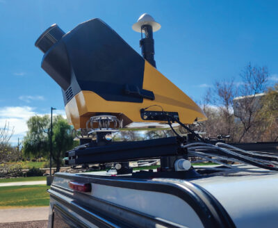
The mounted YellowScan Surveyor Ultra 3, a dual-purpose drone and mobile mapping LiDAR system with 360-degree field of view and 32 laser beams.
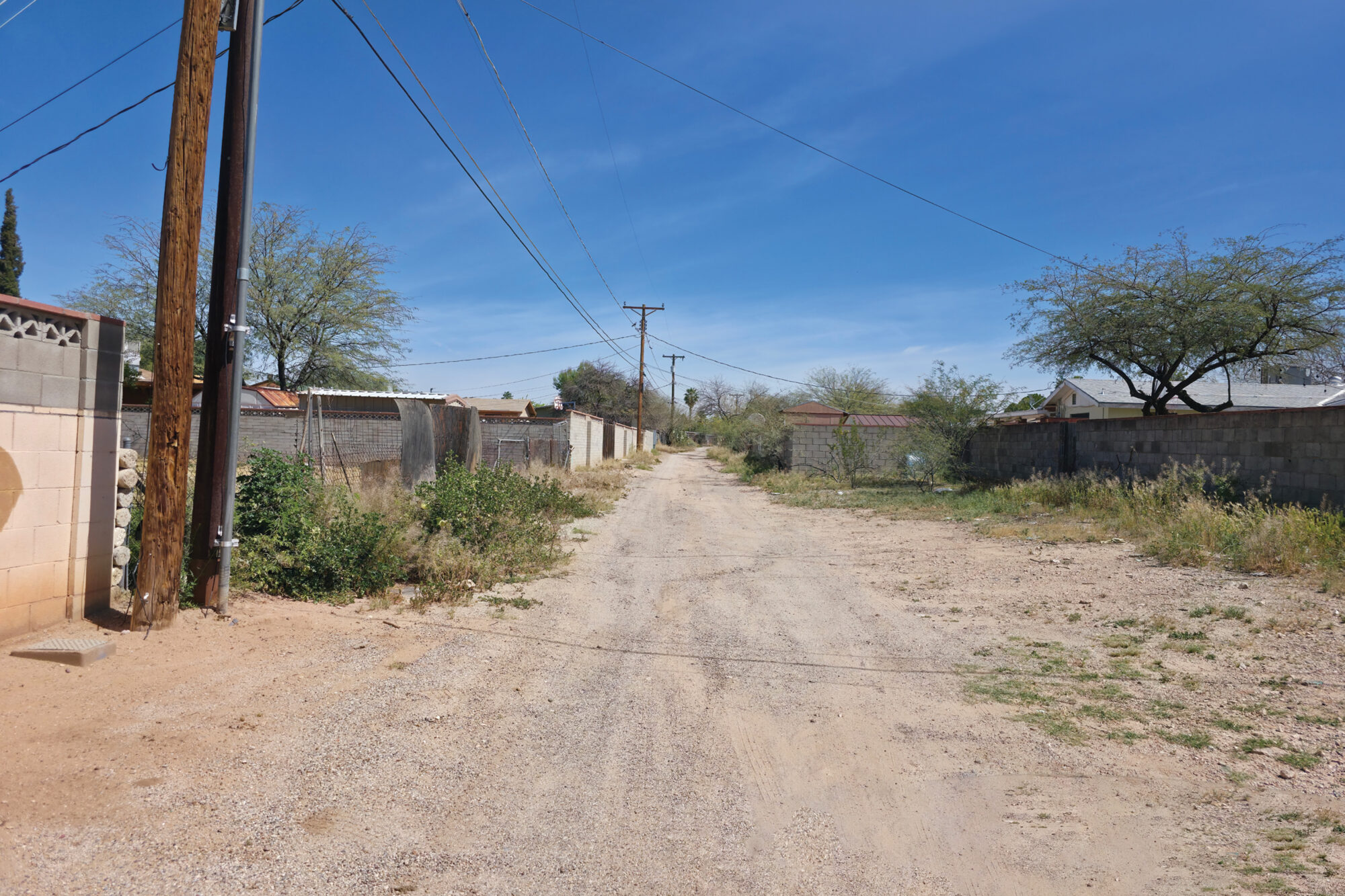
In April 2025, a Darling crew arrived on site to survey and map the 160-acre area of interest (AOI). And apart from the sizeable AOI, one particular challenge became clear after their initial site visit: this was a highly populated, active neighborhood with significant traffic. That risked the quality of LiDAR data.
“LiDAR mobile mapping sensors capture everything they see, which is a fantastic feature of the technology,” says Kris Brandt, Darling’s reality capture manager. “It also means you may capture objects you don’t want. If we have someone tailgating us in a car because we’re going 10 miles an hour, the entire rear data set is ruined. So, to ensure we have little to zero traffic, we chose to collect the data between 1 am and 4 am.”
Sleepless nights
To prepare for data collection, a team localized their GNSS base to the Pima County Control network and used a Trimble R12i GNSS receiver and Trimble S6 total station to establish both sparse and dense control at 2-centimeter accuracy. Control points were spaced evenly throughout the project area — every road had control points at each end and in the middle — and to georeference the LiDAR data, they set 75 ground control point targets and captured the coordinates of each with the total station.
The Darling mobile mapping crew was then ready to drive the neighborhood with its YellowScan Surveyor Ultra 3, a dual-purpose drone and mobile mapping LiDAR system with 360-degree field of view and 32 laser beams.
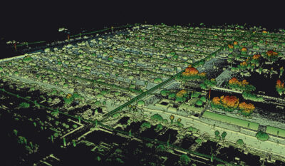
From the street to the desktop, the 3D view of Mission Manor from the YellowScan mobile mapping system.
With the instrument mounted on their vehicle — the proximity to the airport prohibited drone operations — the two-person team calibrated the system’s IMU by driving around a block a few times. Having divided the collection into three sections for efficient driving routes, they then chose the first portion for capture.
“We planned our route meticulously,” says Brandt. “We strategized from the scanner’s point of view, and what it would see as we drove, so we knew exactly where we would be at what time, and which direction we would be heading. Knowing the environment you’re capturing, its obstacles and how the scanner is going to view those enabled us to develop a successful collection plan.”

Seventy five ground control points were spaced evenly throughout the project area to georeference the 3D data.
Guided by the pre-programmed route in Google Maps on Brandt’s phone, they drove each road twice from each direction, capturing everything in their path, from the road surface to the tops of trees at speeds ranging from 5-15 mph. After each section, Brandt checked the data for completeness before moving on to the next area.
“A really unique feature of the YellowScan Ultra scanner is you can immediately check data in the car,” says Brandt. “I could pull the flash drive from the scanner, plug it into my laptop, and view the processed point cloud within 5-10 minutes of ending the collection. That enabled us to flag any holes or issues and either plan to capture that with mobile again or a terrestrial scanner.”

After individual processing the YellowScan and Leica data were merged into one using TerraSolid software.
In three hours, the Darling team completed 56 total passes covering 28 unique paths of roads and alleyways, capturing approximately three billion points and hundreds of gigabytes of raw data.
For the impassable or overgrown alleys, a crew returned again in the wee morning hours to supplement the data gaps with a Leica P20 laser scanner, a terrestrial survey that required 25 set ups and three hours in the field.

One of the AOI streets captured in 3D by the YellowScan system.
“For the amount of assets HDR needed identified and mapped across this large AOI, it would’ve taken us months to complete with traditional land surveying, and the risk of missing something would’ve been high,” says Brandt. “With laser scanning, we were done in two nights. And we captured everything.”
Repeat business
Back in the office, the YellowScan data was processed using its Cloud Station desktop software to georeference the 3D points, refine the trajectory, and generate a point cloud. Leica Cyclone Register 360 software processed the terrestrial LiDAR data. And TerraSolid integrated and merged the mobile and terrestrial datasets into one, rectifying control, and reducing point density from 150 Gb to 8 Gb, a process that took one week in total.
For the final deliverables, Darling created cm-accurate 3D CAD drawings, mapped the assets as vector features, and decimated the ground classification from 200 million to 87,000 points to produce a more manageable, data-rich product. In August 2025, they delivered the topographic drawings to HDR.
Darling Geomatics’ YellowScan Surveyor Ultra 3. According to Darling’s Kris Brandt, the scanner enables users to immediately check data in the car.
“We received what we asked for, and more,” says Hielema. “The data accuracy is incredibly tight and it’s complete. That not only helps us have a comprehensive picture of the AOI for design, but when we start to install the new pipes, we have historical data that we can refer to if needed. Although this was my first collaboration with Darling, compared to other service providers with which HDR has frequently worked, this experience was night and day. They were extremely responsive, very responsible, and really helpful.”
Based on the success of this collaboration, HDR contracted Darling to support their data-acquisition needs on the next Mission Manor phase and to provide survey services for a local wastewater facility.
For Manos, the repeat business and reputation for being helpful and reliable validate that she and Darling are on the right trajectory to grow from strength to strength. Choosing renewal, saying “Yes” to leading Darling, has not erased her personal losses, but it has given her a place to put her energy, her care, and her voice. In choosing to build, she’s carrying her legacy and Darling’s legacy forward, shaping a future that honors both love and loss.
Mary Jo Wagner is a Vancouver-based freelance writer with 25 years experience in covering geospatial technology. She can be reached by phone at: +1 604 221 4583; or e-mail: mj_wagner@shaw.ca