“The surveyor’s fundamental responsibility to serve as the legally accountable source of truth for spatial data remains unchanged.”
After decades of incremental improvements, the convergence of digital technologies, advanced sensors and cloud connectivity is fundamentally transforming how surveyors work, what they deliver and which skills are needed to succeed. Rather than simply replacing traditional tools with digital equivalents, this development represents a complete reimagining of field-to-office workflows and the surveyor’s role in the broader construction ecosystem.
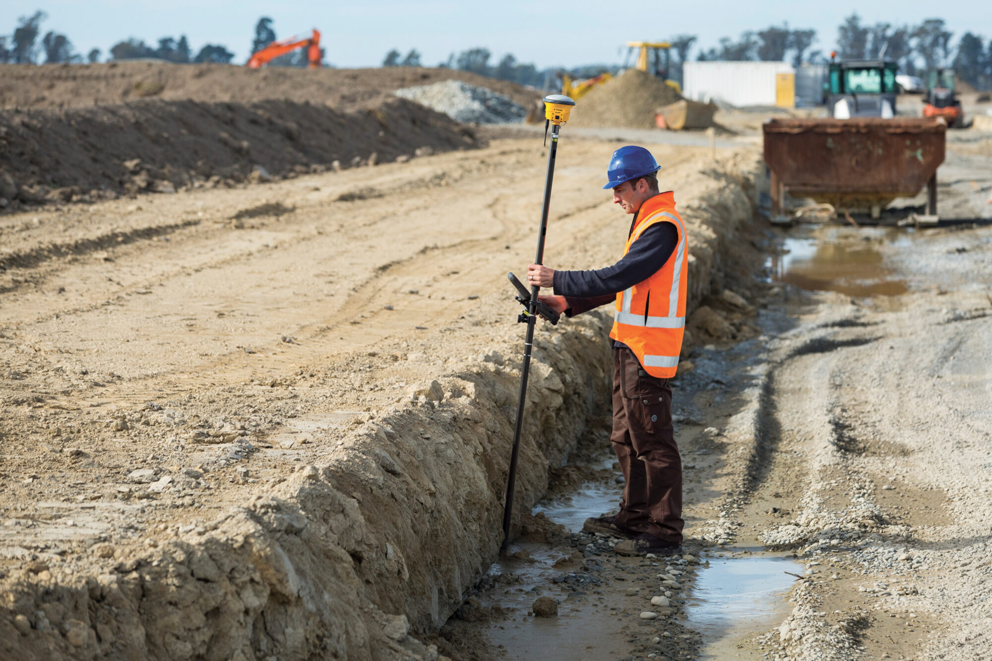
Measurements and calculations generated in the field are instantly shared with the office. Photo credit: M. Harrington, Trimble.
Breaking down field-to-office barriers
Modern connectivity raises expectations across all industries, and surveying is no exception. Field crews now operate with the understanding that information will flow instantly between the site and office, enabling quick decision making and rapid response to changing conditions. This level of connectivity has profound implications for productivity.
If a crew member is absent, other personnel can access current project information in the cloud and pick up where they left off. The field crew has the ability to make informed decisions without waiting for office support, which reduces downtime and keeps projects moving forward even when staffing challenges arise.
Continuous connectivity also reduces the need for repeat site visits. Access to design models, background maps and historical data allows surveyors to verify measurements, resolve discrepancies and answer questions while in the field instead of dispatching crews for additional fieldwork.
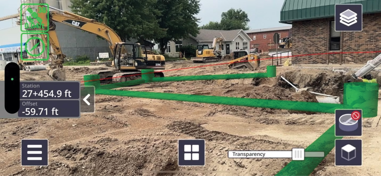
Precise measurements displayed in Trimble Access expedite inspections. Photo credit: Frontier Precision
Standardization as a productivity multiplier
As surveying firms face workforce transitions with experienced professionals retiring and recent graduates beginning their careers, standardization emerges as a critical priority. Organizations increasingly recognize that consistency across workflows, naming conventions and data structures directly impacts efficiency and reduces training time for new personnel.
Rather than every project or crew developing their own approach, standard operating procedures ensure repeatability and quality regardless of who performs the work. By establishing consistent feature code libraries and workflow best practices, surveyors ensure that the data they collect in the field arrives at the office already organized appropriately. This front-end investment in data structure pays dividends throughout the project lifecycle, expediting drafting, reducing errors, and creating deliverables that meet client specifications without extensive post-processing.
The Trimble software suite offers an end-to-end workflow with Trimble Access in the field fully integrated with Trimble Business Center in the office. Data can be collected with a mixed fleet of sensors and seamlessly made available for processing, and analysis tools are increasingly available in the office or the cloud.
In-field visualization software like Trimble SiteVision enhances productivity by overlaying digital models onto real-world environments. Photo credit: Frontier Precision.
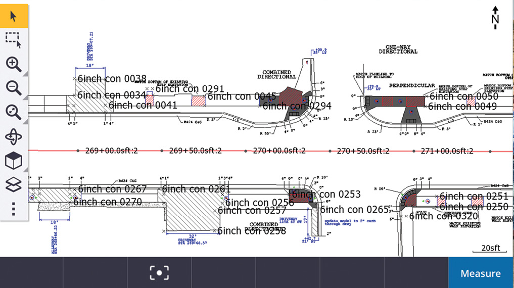
Go digital: The model-based revolution
The surveying industry is in the process of transitioning away from paper-based workflows. Some jurisdictions now mandate digital deliverables to qualify for government funding or to meet regulatory requirements.
In a model-based workflow, surveyors work with a digital representation of the design intent alongside measured data showing existing conditions. They can overlay background maps showing roads, utilities, and infrastructure, creating a rich contextual environment for decision making. This multi-layered digital workspace allows surveyors to adapt their approach on the spot, selecting the most appropriate data sources and methods for each situation.
The concept of a single source of truth is central to modern surveying practice. When all project stakeholders work from the same digital model stored in the cloud, everyone has access to current information. Annotations and updates made in the field become immediately available to office staff, who may review and validate data while the surveyor is still on site. This eliminates the traditional delay where field notes might take a day or more to be transcribed and incorporated into project records.
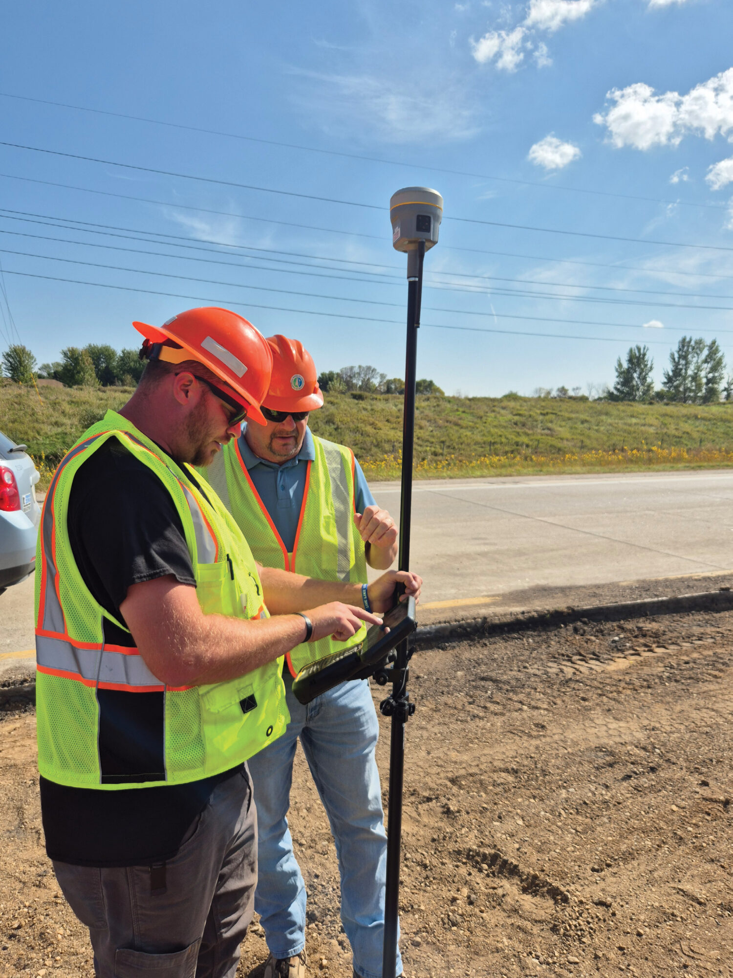
Powerful handheld devices streamline surveying workflows and make large digital models available to field crews. Photo credit: M. Harrington, Trimble.
Computing in the field
The current capabilities of handheld data collectors and field devices are remarkable. Modern controllers handle datasets that would have been unthinkable a decade ago, making full 3D models, dense point clouds and high-resolution imagery accessible on portable devices in the field.
This computational power, combined with the connectivity features that enable a cloud-based storage approach, lets surveyors work with filtered task-specific data rather than being overwhelmed by the full project dataset. A surveyor working on foundation layout may view just the relevant portions of the design model. Later, when moving to a different phase, they can retrieve additional data as needed. This ability to scale data access based on immediate requirements keeps field devices responsive while still providing complete project information when necessary.
Field devices now support validation and comparison capabilities that previously existed only in office environments. Surveyors compare scan data against design models while still on site, identifying differences and resolving issues before leaving the field.
Seeing is believing
Augmented reality capabilities are bridging the gap between digital models and the physical world in powerful new ways. By overlaying design information onto live views of the construction site, surveyors and contractors visualize where elements should be located before they are built. This technology helps identify conflicts, verify placement, and communicate design intent more effectively than traditional methods.
The ability to visualize complex 3D data in intuitive ways makes surveying technology more accessible to broader project teams. Rather than requiring specialized training to interpret traditional surveying outputs, stakeholders gain an understanding of site conditions and design requirements through visual representations that map directly to their physical experience of the site.
Sensor synergy
Perhaps the most significant shift in surveying over the past decade has been the transition from discrete point data collection to multi-sensor data capture. Where surveyors once recorded individual points and lines using GPS or total stations, today’s professionals work with entire surfaces and realistic 3D models.
Surveyors routinely deploy multiple sensor types on projects, including drones and mobile mapping systems, for redundancy and validation. The shift to multi-sensor environments introduces a new complexity but also delivers more robust and reliable results. By capturing overlapping data, surveyors gain confidence in their measurements and expose errors that might have gone unnoticed in single-sensor workflows.
The Minnesota Department of Transportation (MnDOT) is implementing connected digital workflows, 3D modeling, augmented reality, and cloud data storage to streamline critical construction projects. Facilitated by the field application Trimble Access Measure Service connected to the Infotech Mobile Inspector, their expedited inspection process reduced project certification time by an impressive 80% on a $4.7 million project, leading to significant efficiency gains in documentation and payment verification. Inspectors worked more quickly thanks to immediate access to all necessary data stored in the cloud.
Digital data stewardship in the office
As surveying technology advances, the role of surveyors expands significantly. Today’s surveyors are not only geospatial professionals but also data managers responsible for collecting, organizing, and validating complex datasets. They must understand how to structure data for downstream use, ensure its accuracy, and add the contextual information that transforms raw measurements into actionable intelligence.
This evolution shifts the balance of surveying work in the office away from tedious tasks, such as cleaning point cloud data or exporting files in different formats, toward higher-value activities that leverage professional expertise. Automated feature extraction and attribute assignment expedites routine data handling, freeing surveyors to focus on complex problem solving, quality assurance and working with advanced technologies like laser scanning, 3D modeling, and augmented reality.
The surveyor’s fundamental responsibility to serve as the legally accountable source of truth for spatial data remains unchanged, while the tools and methods for fulfilling this responsibility continue to evolve. Modern surveyors must combine traditional knowledge of measurement principles, boundary law, and survey standards with new competencies in data management, sensor fusion, and digital workflows.
Advancing with integrity
Changes in the surveying profession reflect broader trends across all construction and engineering disciplines. As projects become more complex and timelines compress, the ability to capture, manage and share accurate spatial data efficiently becomes critical. Surveyors who embrace these technological changes and develop the expanded skill sets they require will find themselves better positioned to deliver value to clients.
The focus on automation, standardization and connectivity continues to drive productivity improvements. However, accuracy, reliability and integrity remain the core professional standards that surveyors uphold. Technology serves these standards, enabling surveyors to fulfill their essential role with greater efficiency and confidence than ever before.
Stephanie Michaud is a director of product management for Trimble.