The surveying profession enters 2026 amid accelerating digital transformation, driven by pressure to deliver faster, more accurate results while navigating workforce shortages, evolving client expectations and rapid technological change. The convergence of artificial intelligence (AI), cloud-based collaboration platforms and interoperable hardware and software is fundamentally reshaping how spatial data is captured, processed and shared.
According to experts at Trimble, the following six trends will help define the landscape for surveying professionals in the year ahead, offering both opportunities and imperatives for those seeking to leverage technology.
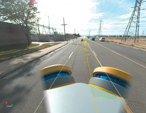
1 Reality capture goes mainstream
Reality capture has evolved from a specialized service to an increasingly accessible toolset that surveying firms of all sizes can deploy. The digital technology has proven its worth through enhanced precision, improved safety outcomes and accelerated project timelines, but 2026 will see adoption expand dramatically as user-friendly tools and broader platform support make the technology easier to implement.
“Reality capture technology is already invaluable, but it will become even more democratized in 2026,” says Arnaud Lezennec, senior applications engineer at Trimble. “New user-friendly tools will enable even more comprehensive data collection and in-field treatment for faster and improved decision making, as well as capture from mobile phones and robust mobile mapping systems.”
Reality capture is becoming an integral part of project management workflows. Surveyors can now document conditions, visually track progress and collaborate on solutions in real time. Enhanced by AI, machine learning and cloud-based platforms, spatial data serves as a common visual language that helps all stakeholders align efforts across projects and reduce misunderstandings.
Surveying firms that weave reality capture into their core service offerings can differentiate themselves and deliver more comprehensive value. As the approach becomes standard practice, clients increasingly expect rich digital deliverables rather than traditional survey products alone.
2 Autonomous progress: Evolution not revolution
The construction industry’s journey toward autonomy continues to unfold as an incremental process. For surveyors working on earthmoving and civil construction projects, 2026 will bring steady progress in the foundational technologies that enable smarter machines and workflows.
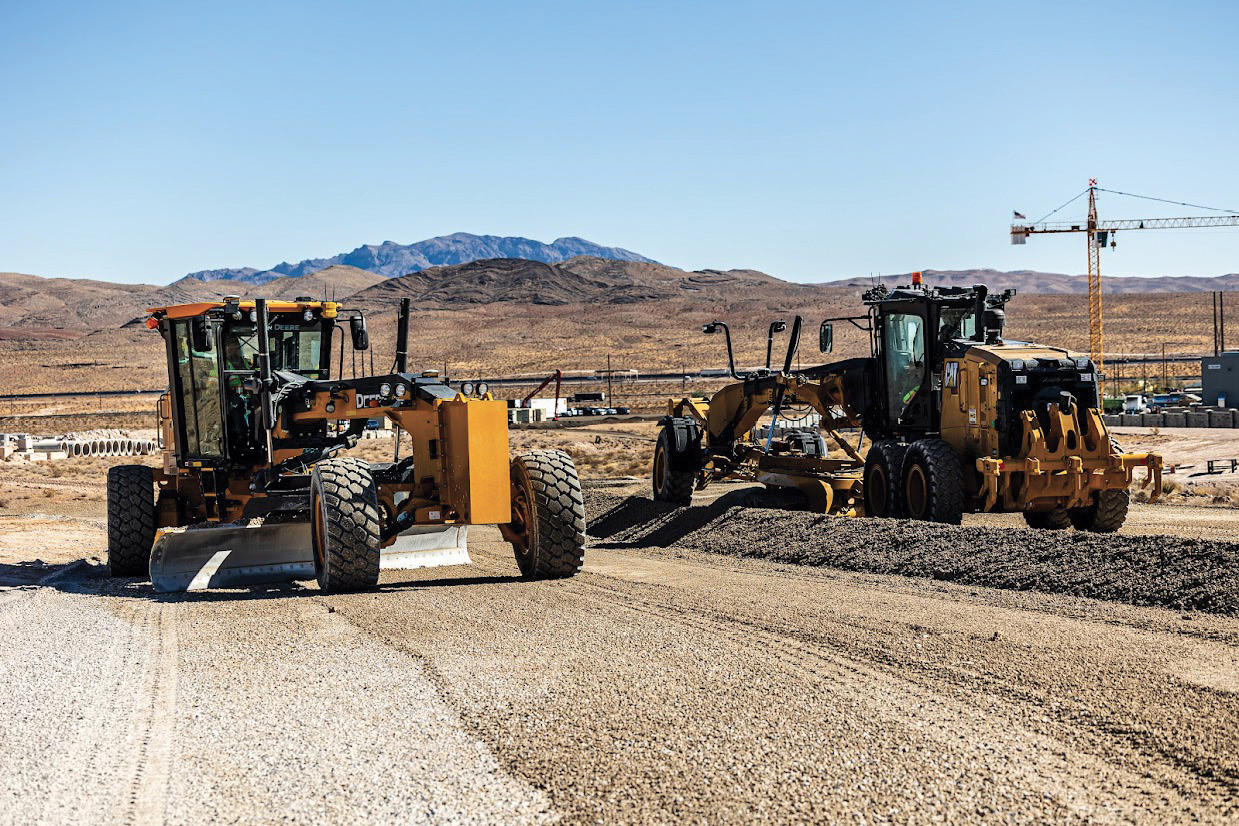
“The path to autonomy in construction is an evolution more than a revolution, and that will continue in 2026,” explains Ian Welch, director of engineering, Civil Construction Field Systems at Trimble. “We expect to see continued advancements across the industry in what will be the foundation to a future in which tasks and machines are more automated.”
Machine control systems are becoming standard equipment for modern earthmoving projects, no longer viewed as optional technology but as essential infrastructure. For surveyors, this underscores the growing importance of providing accurate, timely data that feeds these systems. Site control work, digital terrain models and as-built verification become even more critical as machines rely on precise spatial information to operate efficiently and safely.
3 Long-term value in GIS-centric management
Municipalities, state agencies and private asset owners face mounting challenges in managing vast, aging infrastructure with constrained resources. This reality creates demand for surveyors who can deliver data that feeds comprehensive asset lifecycle management systems. The intersection of 3D GIS, advanced modeling and spatial data capture opens opportunities for surveyors to provide ongoing value far beyond traditional project boundaries.
“Innovations in 3D GIS and modeling technology are creating richer, more precise models of public assets,” notes Chris Bell, vice president, AECO Industry Strategy & Product Marketing at Trimble. “Concurrently, GIS-centric asset lifecycle management is being redefined by AI, real-time spatial insights and secure data sharing. The result is easier real-time collaboration, smarter decision making, reduced risk and enhanced efficiency throughout every stage of an asset’s lifecycle.”
Infrastructure owners increasingly understand that information collected during planning and construction phases retains value for decades. As much as 75% of an asset’s total cost of ownership accrues during operations and maintenance. Spatial data helps assess performance degradation and pinpoint maintenance needs, enabling a shift from reactive fixes to predictive maintenance that can reduce costs by as much as 40%.
Surveyors can expand their thinking beyond the initial site survey or as-built documentation. Firms that frame their services within the broader context of lifecycle asset management will find recurring revenue opportunities and stronger client relationships built on long-term partnerships.
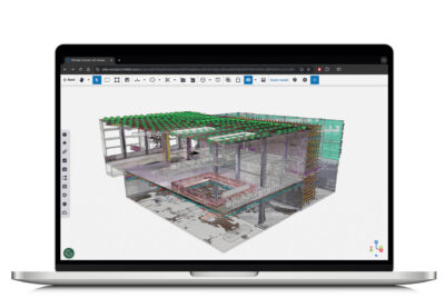
4 Common data environments take hold
As the construction industry evolves into a data-driven sector, the adoption of common data environments (CDEs) is accelerating. For surveyors, CDEs represent both a delivery platform and a collaboration tool that fundamentally changes how spatial information integrates with broader project data. Rather than producing static plans or point clouds that exist in isolation, surveyors increasingly contribute to dynamic, shared environments where their work informs real-time decision making.
“CDEs are critical because they minimize time contractors waste trying to search for information, a vast majority of which goes unanalyzed and unused,” says Chris Peppler, vice president, Platform and Product at Trimble. “CDEs eliminate this inefficiency by consolidating critical data from design, engineering, fabrication, construction and maintenance into a secure, accessible hub.”
These platforms bridge the gap between physical and digital construction data, enabling the development of digital twins. Firms that understand how to work within CDEs and deliver data in optimized formats will be better positioned to meet evolving client expectations.
5 Interoperability unlocks integration
The complexity of modern projects makes data sharing across diverse teams and technology platforms essential. Surveyors often work at the intersection of multiple stakeholder groups, each using different software systems and workflows. True interoperability ensures that spatial information can flow seamlessly between systems so every stakeholder can access the same data within their preferred tools.
“In the year ahead, construction technology vendors, including Trimble, are expected to accelerate efforts to enhance interoperability, delivering greater value to contractors,” Peppler explains. “This includes building workflows and integrations between construction technology ecosystems, providing more opportunities for construction teams to share project data regardless of the various software deployed for a given project.”
Improved interoperability reduces friction in data handoffs and expands the potential client base. Firms no longer need to worry whether their deliverables will function within a client’s existing technology stack. However, this also raises expectations for data quality and formatting. As systems connect more easily, clients will expect survey data that integrates seamlessly.
6 Visualization drives collaboration
The shift toward visualization-driven workflows transforms how surveyors’ work integrates with the broader project lifecycle. Design conversations increasingly take place directly within 3D models rather than on traditional 2D plans, enabling quicker iterations, faster workflows and stronger alignment throughout design and construction.
“Spatial data becomes the foundation for collaboration,” says Sandra Winstead, senior director of Product, Architecture & Design at Trimble. “As discussions are centralized, designers and other stakeholders can provide context, resolve questions and make decisions in real time.”
This approach extends into construction and operations where common data environments provide consistent access to documentation, context and visualization. Project owners benefit from seamless digital handoffs at completion, receiving rich datasets that inform long-term asset management strategies. Surveyors can expand their deliverables beyond traditional survey products to include visualization-ready data.
Firms that deliver survey data optimized for 3D visualization and building information modeling (BIM) integration position themselves as essential partners in collaborative workflows rather than simply vendors of measurement services.
Looking ahead: Opportunity in transformation
The surveying profession enters 2026 positioned at the center of a digital revolution that promises to enhance both the quality of work and the quality of professional life. Reality capture tools that once required substantial capital investment now fit within reach of firms of all sizes. Automated systems handle routine tasks, freeing professionals to focus on complex problem-solving and client relationships. Common data environments and visualization tools elevate surveyors from data providers to collaborative partners embedded in project teams from conception through long-term asset management. The outlook for surveyors willing to embrace change is positive as the built environment becomes increasingly digital.
Linda Duffy is a consultant with Apropos Research, an independent firm providing market research and marketing communications services to the geospatial and remote sensing community since 2003. Contact her at lduffy@aproposresearch.com.