When fourth grader Luke Gutierrez was assigned Mission Soledad for his California mission project—which is a rite of passage for many schoolchildren in the state—he quickly ran into a problem. There were no clear architectural plans, few reliable images, and no accurate scale references to work from. Fortunately for Luke, he had something most students don’t: a working knowledge of 3D laser scanning and after-school access to high-end survey equipment.
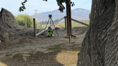
Surveyors find creative ways to remain hidden during the scan-capturing process. Luke took full advantage of his size and hid underneath the equipment while it operated.
So, he asked his dad, Jesse Gutierrez, who is head of 3D scanning at Modesto, California-based Original Survey Solutions, a simple, but genius question: “Why can’t we just scan it?”
That suggestion led to a full-scale terrestrial LiDAR scan of one of California’s least-documented historic missions, a father-son field trip that generated nearly 30 gigabytes of measurable data, and a story that illustrates the surprising ways that surveying can preserve history, support learning and help shape a company’s culture.
From Fourth Grade to Field Conditions
The roots of this story began during the pandemic, when Luke was his father’s constant work companion. Now he’s hooked.
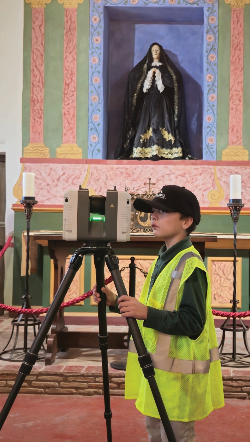
Luke looks into the screen on the laser scanner as he assists in lining up the next scan.
“Luke’s school is right down the street from our office, so for the past few years, he’s been coming in after class and getting a lot of exposure to what we do,” says Jesse. “He’s helped run the scanner, scanned our house, scanned the office. He’s actually done the work himself. So, when he came home with his mission assignment and told me he got Mission Soledad, we looked it up to see what kind of plans or information we could find online. Turns out, the mission’s been destroyed and rebuilt multiple times, and there were barely any usable plans available.”
When Jesse asked OSS President and Founder William Paul if he could use the scanner for his son’s project, the response was immediate. “I thought it was brilliant,” says Paul. “We put the firm’s resources behind it, gave Jesse the day to do it on the clock and volunteered our equipment.” OSS also donated the time for Jesse to create the deliverables.
Paul did have one non-negotiable requirement: “Luke had to be part of all of it. There’s no way he was sitting this one out.”
A Lesson in Culture
Founded in late 2023, OSS has grown rapidly to a 36-person firm serving the Western United States. That smaller-firm agility, along with a culture that Paul specifically designed to attract and retain top-tier surveyors and engineers, made the decision even easier.

“Since we started this company, I’ve been focused on trying to build the kind of firm that I’d want to work at,” Paul said. “We try hard to make moments like these for the people who work here, and this is one of the reasons that our recruitment and retention rates are so high. We just keep adding great people, and I want to add more.”
His approach is proving successful. In less than two years, OSS has grown from a startup to its current size, and has added both civil engineering and regulatory compliance capabilities. Paul says that the firm competes not just on technology, but even more on “follow-through and fundamentals.”
Jesse agrees. “It’s the kind of place where, if you have an idea, and it helps someone or it’s good for the project, you’ll get support. In my experience, that’s rare.”
Gaining Access and Capturing the Mission
To facilitate the scan, the team reached out to the California Missions Foundation (CMF), which helps preserve and promote the 21 missions that dot the California coast. CMF quickly arranged access to the site and gave Luke a private tour of the historic structure.
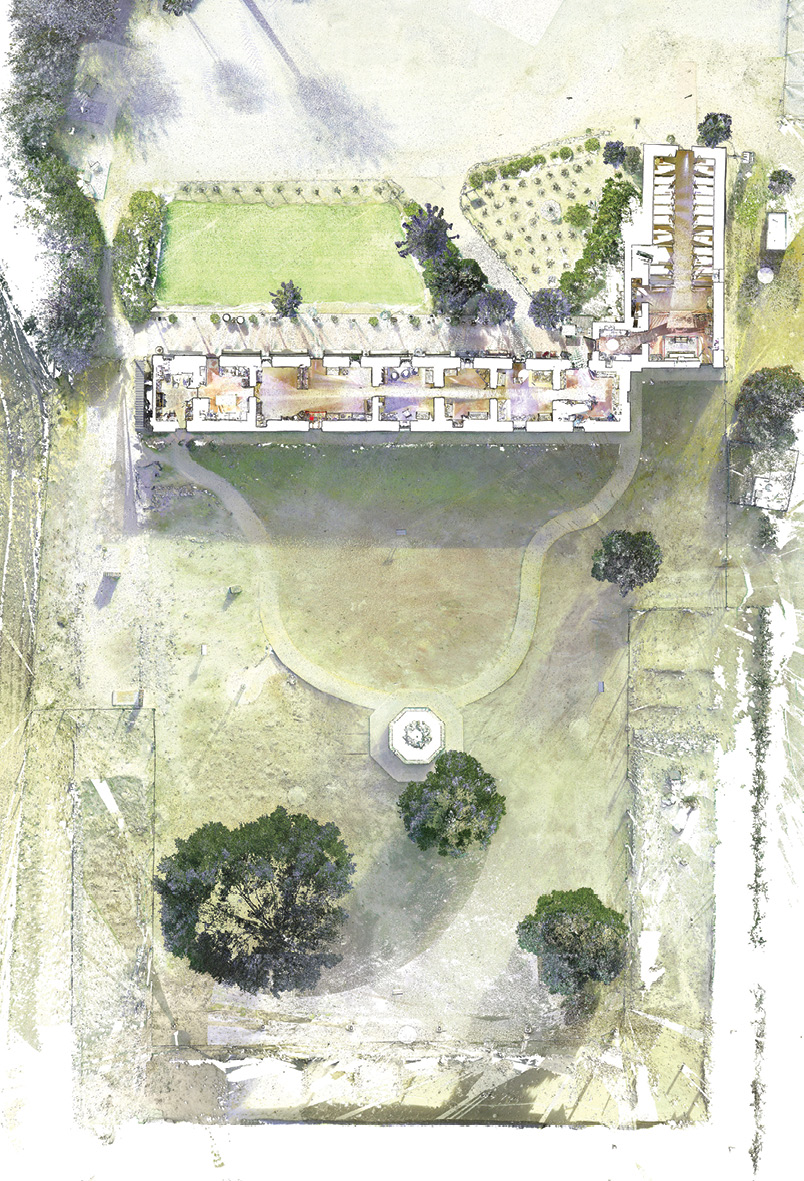
An overhead site plan was generated from the comprehensive point cloud. This was plotted to scale and used as the backdrop on the dimensionally accurate Mission model that Luke made.
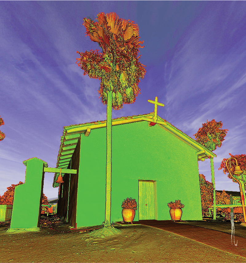
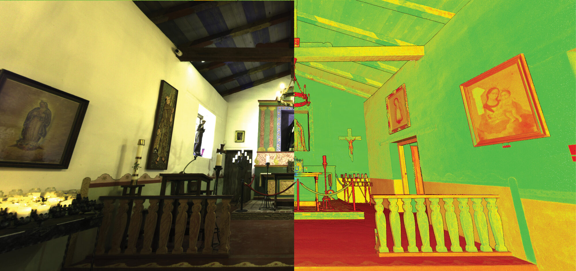
In one day, Jesse and Luke used a Leica RTC360 LiDAR scanner to capture both the interior and exterior of the mission. The device collected over 1 million measurements per second, and OSS produced a detailed point cloud model of the mission, accurate to within a quarter inch, along with stitched imagery for full-color visualizations.
The scan produced:
- Full interior and exterior point clouds
- Natural and reflectivity-based color visualizations
- CAD-extractable floor plans and elevations
- Data for historical preservation, documentation, and education
Jesse and Luke used post-processing software to extract 2D elevations, which Luke referenced when building a physical scale model of the mission. Jesse overlaid the original scan data to check the model’s accuracy, a level of precision that didn’t go unnoticed.
“This leans into Jesse’s personality a little bit,” says Paul. “He is incredibly attentive to making sure things are just right; even a fourth-grade school project. It’s kind of funny in a way, but it’s also indicative of our approach to accuracy and the importance of it in the work we do.”
History Captured in 3D
While the project began as a school assignment, it quickly took on broader value. Luke’s teacher admiringly noted that the firsthand experience gave Luke the confidence and insight to deliver a far more detailed and informed presentation than he typically sees from students at this age. The CMF was impressed enough to invite Jesse, Will, and Luke to present the project at its annual conference in February 2025, again, with the time paid by the company.
At the presentation, Will summed up the achievement by saying wryly, “Luke’s model is to scale; I don’t know about the other kids in the class.” Luke received a standing ovation.
The OSS team presented flythroughs and animations created entirely from the ground-based scan—no drones, just terrestrial LiDAR. (You can find a video of their presentation here:
Preservation Opportunities in Scanning
While the impact on the audience was clear, the technical outcome was just as compelling.
Mission Soledad now has a full 3D scan that can be used for non-invasive preservation, measured documentation and future reconstruction, if it’s ever needed.
“I think part of the value of something like this isn’t just the technical data,” says Paul. “No one in the audience was an engineer or CAD user. But the visual impact generates excitement, is accessible by decision makers and can help raise funds for this worthy non-profit organization. If a picture is worth a thousand words, what is a full color animation based on a highly accurate 3D model worth?”
Laser scanning for cultural preservation is not new, but it’s still underutilized by many firms focused exclusively on commercial or infrastructure work. In recent years, 3D scan data has been used to help rebuild fire-damaged landmarks like the Notre-Dame Cathedral in Paris and to preserve UNESCO World Heritage Sites in Syria and Iraq that were destroyed by conflict.
In California, missions like Soledad are vulnerable to climate, seismic activity, and vandalism. But few have full digital twins, which could create an opportunity for surveyors to contribute to preservation efforts in meaningful ways.
“This project turned into a case study in how surveying can bridge past and present,” said Paul. “We didn’t invent a new tool, but we used what we had in a different way.”
The model produced by OSS allows for non-destructive analysis, accurate documentation and potential reconstruction should disaster strike again. And unlike photography, the point cloud provides true measurability, a data-rich artifact for future engineers, architects, and historians.
Surveying’s Role in Preservation and Education
Another facet of the mission project is that it highlights several areas where professional surveying overlaps with public benefit:
- Digital preservation of at-risk historic sites
- Support for education through measurable, immersive tools
- Demonstration of how terrestrial LiDAR exceeds traditional photography
- Opportunities to introduce the next generation to the profession
Paul adds that the decision to support the project wasn’t strategic; it was instinctive. “This wasn’t a marketing campaign. It was just the right thing to do. But it also shows who we are as a company and what this profession can do when we look beyond the expected.”
Future Ramifications
Somewhat understated in this human-interest story is the effect that an experience such as this can have on a person’s ultimate career choice. Luke’s exposure to his dad’s work, and his specific first-hand experience on his mission project, serves as an invitation into the world of surveying. These are more than just educational moments; they help reveal the depth and breadth of surveying to people who might otherwise never encounter it. This is especially true of students and others who typically aren’t aware that surveying is a modern, high-tech, and essential profession. The experience communicates this fact not only to Luke, but also to his classmates, his teachers and to members of the CMF, as well as anyone else exposed to the story.
The message is that surveying offers people with a wide range of backgrounds and education the opportunity to work in a prestigious, growing, and vital profession. For the industry to thrive, its leaders and practitioners need to promote this truth more actively, not only to college graduates at job fairs or to mid-career professionals, but also to children and teens still forming ideas about what they might one day want to do and become professionally.
This is why programs like Get Kids Into Survey play such an important role. By offering interactive posters, lesson plans, comics and career path resources, the campaign gives surveyors the tools they can use to introduce the field in a fun, accessible way. It also provides a framework for companies, educators, and parents to be part of the pipeline, one that starts far earlier than a job application.
In this case, Luke Gutierrez didn’t learn about surveying in a classroom or at a career fair. He learned it by being welcomed into a workplace, watching his dad do meaningful work. He wasn’t just tolerated, he was allowed to thoroughly explore the inner workings of the profession and given access to expensive tools and technology that are typically well beyond someone his age. The fact that a company like Original Survey Solutions supported this exploration, and trusted Luke enough to bring him into the field, speaks volumes about how surveyors can engage the next generation through action, not just advocacy.
If the surveying industry wants to attract more smart, curious young people, it needs to meet them where they are—in classrooms, on social media, and through hands-on experiences in the field. Exposure matters. Luke didn’t just learn how to scan a building, he discovered that surveying is a profession rooted in purpose, precision, and creativity. He saw that it leads to tangible, meaningful outcomes. And perhaps most importantly, he saw himself as someone who might do this kind of work one day.
Jerry Guerra, a principal with The JAGG Group, is a writer, researcher and consultant focused on the AEC industry.
Sidebar:
Behind the Scan:
Here are some details about the scan:
- Scanner type: Leica RTC360 LiDAR scanner
- Scan density: Over 1 million measurements/sec
- Accuracy: ±¼ inch
- Processing software: Leica Register 360, Leica Cyclone 3DR, Leica Reality Capture Studio
- Output formats: Colorized point cloud, plan/elevation views, 3D flythroughs
- Data volume: ~30 GB from one day on-site
The resulting digital assets are compatible with CAD and BIM platforms and can serve as the baseline for future preservation, planning, or reconstruction.