Northwest of Vicksburg, Mississippi lies a landlocked portion of Louisiana that you would think rightfully belongs to Mississippi. When General Land Office (GLO) Deputy Surveyor Aaron Hitchcock was there in November of 1823, things looked a whole lot different. Hitchcock accurately located the banks and bends of the Mississippi River as well as Tullos Island. There was no question where Louisiana started and where Mississippi ended. Everything slowly changed over the next 89 years, by accretion and erosion, as Louisiana rightfully and lawfully expanded to the North and East by about five miles. This new bend, in 1912, was called Albemarle Bend and all was well between the States. That was until a violent act of avulsion created the Newman Cut-Off creating a ten-mile oxbow that would eventually, partially, silt in and appear to be that of the State of Mississippi. The Supreme Court got involved and brought in Samuel Stinson Gannett to mark where the river used to be — transferring a paper document to an on the ground survey.
Deputy Surveyor Hitchcock surveyed Township 9 North, Rage 8 West of the Choctaw Meridian and Baseline. The South line of this Congressional Township would become the division line between Political Warren and Issaquena Counties, Mississippi. The other side of the river was surveyed in March of 1824 by Ephraim Ludlow. This was Congressional Township 19 North, Range 14 East of the Louisiana Meridian and Baseline. This became Political East Carroll Parish, Louisiana. The natural changes in the Mississippi River can be clearly traced in the scientific studies and artwork of Harold Fisk.
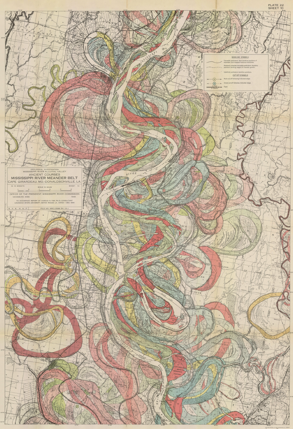
Dr. Fisk was a geologist and cartographer with the United States Army Corps of Engineers and the author of Geological Investigation of the Alluvial Valley of the Lower Mississippi River 1. There were fifteen maps, included in the pocket of the report that showed the current and historic twists and turns of the southerly portion, of the fourth largest watershed in the world2. It is Plate 22, Sheet 10/15, File Number MRC/2588 Sh. 33-J, which shows the area in discussion. You can see, in vibrant color and detail, the remarkable way the Mississippi River has changed since it was first surveyed in 1765 by Lieutenant John Ross, surveyor of the 34th Regiment of the British Army.
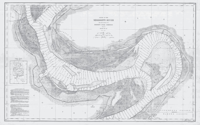
Survey of the Mississippi River, Made under the direction of the Mississippi River Commission, 1913-1915, Chart No. 47.
The Ross map has been quoted as “The most influential map of the Mississippi River on the eve of the American Revolutionary War”3. Other historic meander lines, traced from old maps, are from 1820, 1880 and 1944. After that Dr. Fisk utilized aerial photographs to plot the meanders. When Samuel Stinson Gannett did his survey, he utilized the Fisk Maps but heavily relied upon the most detailed survey of the Mississippi River at the time, the Survey of the Mississippi River, Made under the direction of the Mississippi River Commission, 1913-1915, Chart No. 47. It was with this map that Gannett could retrace what the river’s thalweg looked like in 1912. The Supreme Court record states “The most reliable and accurate record of location of the thread of the main channel of the Mississippi River for the dates in the area specified in section 3 of the decree is that given on chart No. 47 of the Mississippi River Commission Survey of 1913-1915”4.
The State of Louisiana became the 18th State on April 30, 1812. According to the Louisiana Constitution of 1812, the portion of the boundary in discussion runs “…thence along the said parallel of latitude to the river Mississippi – thence down the said river to the river Iberville…”5. The State of Mississippi became the 20th State on December 10, 1817. According to the Mississippi Constitution of 1817, the potion of the boundary in discussion runs “…thence West along the said degree of latitude to the Mississippi River, thence up the same to the beginning….”6 Both States agreed on the common line, that is until it moved in 1912, and navigation fully stopped by 19167. The Supreme Court decree from 1931, in Section 3, stated that the river was in the same place at the Westerly extension of the Political County boundary between Warren and Issaquena Counties, Mississippi8.
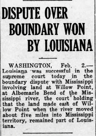
Dispute Over Boundary Won By Louisiana, The Winona Times, February 06, 1931.
This is where Surveyor Gannet was to start his survey. According to Gannett’s final report, he did an incredible job retracing the County line. He found a wooden stake at the Southeast corner of Section 33, Township 9 North, Range 8 West. From this corner he ran his line West through two found line trees, a 24-inch plus Hackberry Tree and a 15-inch Oak Tree9. He replaced the stake with a six-foot-long section of iron angle bar, driven 3 foot deep, as acquired from Vicksburg Boiler and Iron Works.10,11 Gannett went on to perpetuate the Section line by placing four concrete reference monuments where the road and levee crosses.
These reference monuments varied in size, shape, and material, but most had a square concrete base with a conical frustum and bronze disks like the 1927 Oklahoma and Texas State Line Boundary.12 The bronze disks were ordered from the Schoellhorn-Albrecht Machine Company in St. Louis, Missouri for $2.75 apiece, the mixing materials for the concrete came from the Mississippi Lumber Company and the metal forms for the frustum came from Enterprise Plumbing and Metal Works.13
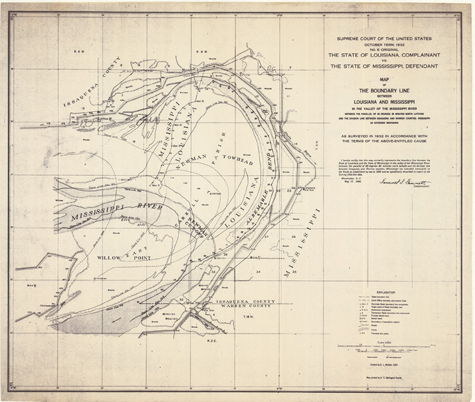
Map of the Boundary Line Between Louisiana and Mississippi In the Valley of the Mississippi River.
Today this road is Mississippi Highway 465, and the location of the East-West section line is a couple of miles Northeast of the old Brunswick Store. The area is labelled as Bellevule (sometimes referred to as Bellevue) on the Warren County, Mississippi General Highway Map.14 For the other end of the silted in section of the old riverbed, things started easy. Gannet, and crew, started about 540 feet from the new bank of the Mississippi River at Monument Zero.15 This was a custom-built concrete monument with a 20-inch square base, 18 inches tall. A conical frustum, 36 inches tall, was placed on top with a bronze disk. Each concrete monument was not only referenced to local control triangulation stations but also referenced by scribing triangles on nearby bearing trees as well as documented by latitude and longitude in the final report.16
Intermediate monuments, identified as Temporary Boundary Line Monuments, were “Marked by a creosoted wooden post 39 inches long and 6 inches square, set 32 inches in ground and a small nail in top marking angle point”17. After the 16th monument the old riverbed was evident and filled with water. After Post 16, the physical monuments with coordinates became only coordinates and lasted until number 51. Each calculated position was identified by true bearing and distance to the next station. The total measured distance from Monument Zero to Calculated Position 51 was reported by Gannett as 52,096 feet or just under 10 miles.18 If that wasn’t enough though, an independent reference line was also run on top of the levee with true bearings and distances also tied to triangulation stations. There were 36 (477-513) of these stations that were marked by six-inch square wood posts.19
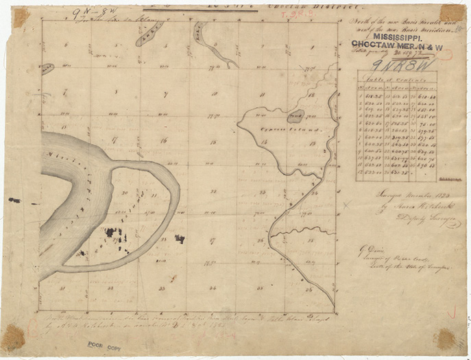
General Land Office Survey of Township 09 North, Range 08 West, Choctaw Meridian and Baseline showing Tullos Island.
The fieldwork was started in October of 1932 and completed by the end of November the same year.20 Although Gannett was appointed Commissioner of the survey, the fieldwork and calculations were performed by his close friend Eugene Long McNair. McNair worked on many of Gannet’s prior surveys, to include New Mexico-Texas, and most notably Oklahoma-Texas. McNair was paid $15 a day for his work as compared to $3 a day for a chainman/rodman and a mere $2 a day for a laborer clearing line and building the concrete monuments.13 All angles were turned at least four times using a transit with a 6.5-inch circle. The distances were measured with a 300-foot steel chain under 20 pounds of tension.21
All the geometry was tied to a true meridian by Polaris observations as well as ties to Mississippi River Commission triangulation stations, specifically the starting station B.M. Noah. The entire survey cost $2,819.62 not counting the office, calculation and report work of Gannett that technically didn’t wrap up until June 08, 1933.22 The report on the fieldwork was filed on May 17, 1933, and the report on all the expenses was filed on June 19, 1933. The final report on October 16, 1933, authorized the payment of $2,600 to Gannett and approved and adopted his prior report and survey. The total cost was $5,419.62 and was to be split equally by both States equaling $2,709.81. The value that Gannett received from 1933 would have been equal to over $62,000 in 2025.23 This completed yet another disputed State line that escalated to the United States Supreme Court.
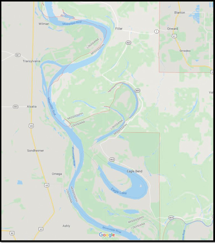
Google map showing Albemarle Bend and the Newman Cut-Off.
Mark Twain always had a way of saying things the right way. He said that the Mississippi River “…is not a commonplace river, but on the contrary is in all ways remarkable”.24 I think, by the time this survey was over, Gannett would have agreed.
Next time we will visit the New Hampshire-Vermont State Line. It will be the last for both Gannett and McNair.
Joseph D. Fenicle, MS, PS is the Program Director and Professor at the University of Akron for its award-winning Surveying/Mapping program. Immediately prior, he was the Chief Surveyor at the Office of the Fulton County Engineer in Wauseon , Ohio for 15 years. He also owns Angular By Nature, LLC, a company specializing in Continuing Education for Surveyors and Engineers across the Nation. Joseph has a MS from the University of Maine, a BS in Surveying/Mapping from the University of Akron and an AAS in GIS/GPS from Hocking College. He is currently working on his Doctorate at the University of Maine as well as his CFedS—Certified Federal Surveyor Certification.
- 1 Fisk, Harold. Geological Investigation of the Alluvial Valley of the Lower Mississippi River. Louisiana State University, Baton Rouge, Louisiana. 1944. Print.
- 2 National Park Service. Mississippi River Facts – Mississippi National River & Recreation Area Minnesota. 04 April 2025. https://www.nps.gov/miss/riverfacts.htm#:~:text=The%20Mississippi%20River%20watershed%20is,Rocky%20Mountains%20in%20the%20west.
- 3 Arader Galleries. John Ross. Course of the River Mississippi. 1775. 04 April 2025. https://aradernyc.com/products/course-of-the-mississipi-from-the-balise-to-fort-chartres-taken-on-an-expedition-to-the-illinois-in-the-latter-end-of-the-year-1765-london-printed-for-robert-sayer-no-53-in-fleet-street-1-june-1773?srsltid=AfmBOor3_WOKR-eorT0U8PRBpV_kh89CEIREwL3EhoISNU4NfoFpVv7Q
- 4 The State of Louisiana v. Mississippi. U.S. Supreme Court. No. 6, Original. 4. 1932. Print.
- 5 National Archives. The Constitution of the State of Louisiana, January 22, 1812. 22 April 2025. https://www.archives.gov/legislative/features/louisiana-statehood/louisiana-constitution.html
- 6 Mississippi History Now. The Mississippi Constitution of 1817. 18 November 2024. https://www.mshistorynow.mdah.ms.gov/issue/mississippi-constitution-of-1817
- 7 The Eunice News. “Louisiana Is Winner In Boundary Suit Against Mississippi.” February 13, 1931. 4. Newspapers.com.
- 8 The State of Louisiana v. Mississippi. 283 U.S. Supreme Court 791. No. 8. 1931. Print.
- 9 The State of Louisiana v. Mississippi. U.S. Supreme Court. No. 6, Original. 5. 1932. Print.
- 10 Ibid
- 11 The State of Louisiana v. Mississippi. U.S. Supreme Court. No. 6, Original. 3. 1933. Print.
- 12 The State of Louisiana v. Mississippi. U.S. Supreme Court. No. 6, Original. 20. 1932. Print.
- 13 The State of Louisiana v. Mississippi. U.S. Supreme Court. No. 6, Original. 2. 1933. Print.
- 14 Mississippi Department of Transportation. General Highway Map Warren County Mississippi. 1:80000. Jackson, Mississippi: Mississippi Department of Transportation, 2015.
- 15 The State of Louisiana v. Mississippi. U.S. Supreme Court. No. 6, Original. 11. 1932. Print.
- 16 The State of Louisiana v. Mississippi. U.S. Supreme Court. No. 6, Original. 11-12. 1932. Print.
- 17 The State of Louisiana v. Mississippi. U.S. Supreme Court. No. 6, Original. 12. 1932. Print.
- 18 The State of Louisiana v. Mississippi. U.S. Supreme Court. No. 6, Original. 30-31. 1932. Print.
- 19 Ibid
- 20 The State of Louisiana v. Mississippi. U.S. Supreme Court. No. 6, Original. 4. 1932. Print.
- 21 The State of Louisiana v. Mississippi. U.S. Supreme Court. No. 6, Original. 5. 1932. Print.
- 22 The State of Louisiana v. Mississippi. U.S. Supreme Court. No. 6, Original. 7. 1933. Print.
- 23 What is $2,600 in 1933 worth in 2025? 22 April 2025. https://www.amortization.org/inflation/amount.php?year=1933&amount=2600&to=2025
- 24 Twain, Mark. Life on the Mississippi. Harper & Brothers Publishers, New York, New York. 1917. Print.