High-precision seafloor positioning in Japan offers insight for worldwide surveyors
In a region where seismic activity is an ever-present threat, Japanese researchers are pushing the boundaries of geodetic observation to forecast earthquakes with greater precision – and the methods and technologies being used offer a fascinating look at how real-time GNSS corrections are transforming how we measure the Earth’s movements, even on the ocean floor.
At the forefront is Japan’s Earthquake and Volcano Research Center (EVRC) at Nagoya University. Located on an island nation positioned between four tectonic plates, Japan faces unique challenges that have driven innovations in geodetic observation networks. For decades, the EVRC has worked diligently to develop improved maps and tools for predicting earthquakes, including monitoring crustal deformation in Japan’s seismically active Tokai region that is home to the Nankai Trough, a fault zone considered a likely source of a future megathrust earthquake.

A Trimble Zephyr 3 antenna connected to a Trimble NetR9 GNSS reference station receiver utilizes CenterPoint RTX as a static positioning test on Zenisu Reef, Japan, providing centimeter-level GNSS positioning of the seafloor in real-time.
Previously, the EVRC faced significant challenges with measurement delays, as they relied on post-processing kinematic GNSS positioning for offshore measurements. Recognizing the critical need for technology that could acquire centimeter-level GNSS positioning of the seafloor, the center knew real-time measurements were needed to enable immediate detection of seismic potential increases and accurate tsunami predictions following an earthquake.
Real-Time Correction Technology Testing
To address these challenges, the EVRC tested Trimble CenterPoint RTX alongside another correction service. Combining precise Global Navigation Satellite System (GNSS) positioning with acoustic ranging technologies, the team looked to measure seafloor crustal deformations with centimeter-level accuracy. While the competing service showed decreasing positioning accuracy as vessels moved farther offshore, Trimble RTX maintained consistent performance regardless of distance from shore.
Premium equipment such as the Trimble NetRS GPS, Net9 GNSS reference station and Trimble Zephyr 3 antennas have long been part of EVRC’s equipment roster, but this marked the center’s first foray into real-time correction services for offshore applications.
Performance Results
Using CenterPoint RTX on a GNSS antenna and receiver aboard a research vessel, the team tested the performance during both stationary and mobile operations. The results were impressive: 2–3 cm accuracy in real time — comparable to their post-processed solutions. Even more compelling was the stability of the signal offshore, where other correction services typically degrade in performance.
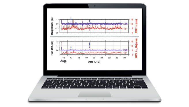
Data from a test sail on an EVRC vessel using CenterPoint RTX between Okinawa and Shingu, Japan shows positioning accuracy within 2–3 cm of the post-processed “true” location, demonstrating successful high-precision offshore positioning. Blue arrows indicate errors in the post-processed data, helping validate the results and build confidence in the solution.
For surveyors working in remote or marine environments, this test confirmed that Trimble RTX corrections offer reliable, high-precision performance without the need for a local base station — a major advantage in reducing setup time and increasing efficiency in the field.
In one notable test, a vessel sailed from Okinawa to Shingu in central Japan while utilizing CenterPoint RTX. Positioning differences from the “real” location, determined via post-processed data, showed just 2-3 cm deviation throughout the entire journey. This test demonstrated successful offshore, high-precision positioning of moving vessels.
A Look Under the Hood: The CenterPoint RTX Engine
Trimble’s CenterPoint RTX correction service is powered by a global network of reference stations and leverages Precise Point Positioning (PPP) to mitigate satellite orbit, clock, and atmospheric errors. Corrections are delivered to users via NTRIP or L-band satellite broadcasts, allowing GNSS receivers to achieve centimeter-level accuracy anywhere on the globe. Proprietary encryption and integrity monitoring ensure dependable data delivery, making it a trustworthy tool even in mission-critical applications like earthquake early warning systems.
The worldwide Trimble reference station network communicates with RTX server software where global GNSS satellite data is synchronized and various biases are calculated, estimated, and calibrated. Per-satellite, global, and regional models are generated for signal code and carrier phase biases of the ionosphere and troposphere.
Surveyors already using ProPoint-enabled GNSS receivers will recognize the value in RTX’s fast convergence, low latency, and multi-constellation support. In addition, Trimble RTX stream protocols are proprietary to Trimble GNSS receivers and employ Advanced Encryption Standard (AES) encryption to prevent spoofing or attacks.
Application to Seafloor Monitoring
The EVRC’s system combines a GNSS antenna with an acoustic transducer. Ultrasonic signals are transmitted from sea surface platforms such as ships, buoys, or autonomous surface vehicles to preinstalled seafloor transponders. The transponders return signals to the surface platform, and distance is calculated from signal travel time and precise ship position. By tracking these distances over time, researchers can measure even subtle crustal motion along the seafloor — something surveyors might liken to a floating control network beneath the ocean.
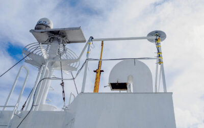
An observation vessel outfitted with a Trimble Zephyr 3 antenna and CenterPoint RTX utilizes high-accuracy GNSS positioning without the use of traditional reference station-based differential RTK positioning infrastructure.
Through Trimble CenterPoint RTX, GNSS positioning precisely measures the positions where ultrasonic signals are transmitted and received. Transponder locations are derived from distances determined at multiple positions around the seafloor transponder. Continuous position determination enables measurement of transponder motion, which represents seafloor crustal deformation.
While many surveyors deal only with land-based deformation or coastal mapping, the methodology has clear parallels: integrating multiple positioning technologies to deliver highly accurate, reliable results in dynamic environments.
Real World Impact
This implementation of real-time corrections showcases how high-precision GNSS technology traditionally used for land surveying can be adapted for specialized applications like seafloor deformation monitoring — and the implications go far beyond this. With faster and more accurate data, the EVRC can support Japan’s disaster preparedness systems, potentially offering longer lead times for tsunami warnings and earthquake alerts.
For survey professionals working in seismically active regions like California, Alaska or the Pacific Northwest, similar technology adaptations could prove valuable for both commercial applications and public safety initiatives. And for surveyors elsewhere in the U.S., the story offers more than a glimpse into global geoscience — it’s a proof of concept. Whether you’re mapping shifting shorelines, monitoring infrastructure deformation, or operating in GNSS-challenged areas, real-time correction services like Trimble CenterPoint RTX are reshaping what’s possible in the field.
Alex Chew, Regional Sales Director APAC, Trimble OEM GNSS, is a sales and management leader with more than 20 years experience in high-precision OEM GNSS receiver technology for positioning and navigation solutions.