Engineers are integral to every stage of a construction project, guiding decisions from early design through to completion. Their expertise directly influences structural safety, operational functionality, and cost management. With so much at stake, engineers have long embraced a culture of peer review to ensure accuracy and accountability.
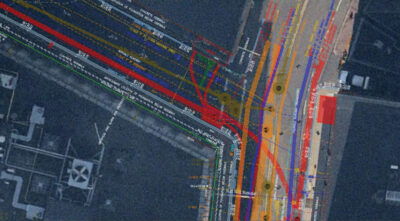
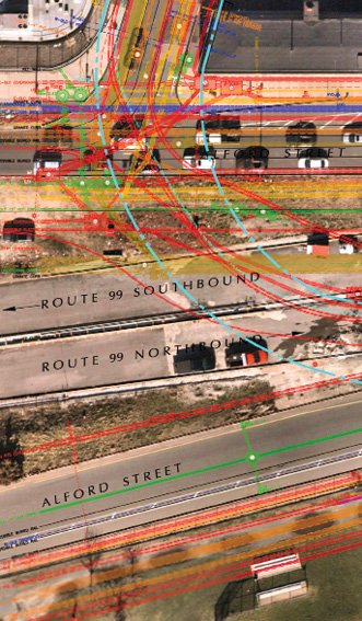
Subsurface utility information with orthoimagery provides a highly reliable map for the above and below ground site conditions.
Yet while above-ground structures are subject to rigorous review and oversight, the infrastructure beneath our feet often receives less attention. Subsurface infrastructure—power lines, water mains, sewer systems, telecommunication networks, and more—forms the essential foundation of the built environment, but it frequently lacks the same level of documentation, visibility, and scrutiny. Many of these systems are aging, undocumented, or poorly mapped, representing a substantial risk to project planning and execution.
In today’s construction landscape, understanding what’s underground is just as critical as designing what’s above it. Expanding the breadth of Subsurface Utility Engineering and Mapping (SUE/SUM) expertise early in the design phase can help engineers identify hidden systems, reduce conflicts, and improve constructability, ultimately driving safer, smarter, and more cost-effective outcomes.
The Importance of Looking Beneath the Surface
Engineering decisions are only as sound as the data they’re based on. Without reliable utility information, teams risk delays, cost overruns, and safety hazards. That’s where high-quality Subsurface Utility Engineering and Mapping (SUE/SUM) data becomes essential. Over the past 50 years, advancements in remote sensing systems and geophysical technologies have made it possible to trace and map underground utilities with increasing accuracy.
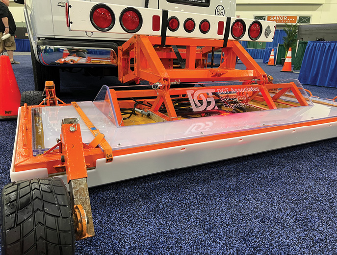
DGT Associates developed a mobile mapping system using a Kontur multi-channel, multi-frequency Ground Penetrating Radar (GRP) system.

The safety benefits are well documented, and in states like Pennsylvania and Colorado, subsurface utility investigations are now required by law. These regulations aim to enhance construction safety, protect underground infrastructure, and support broader underground damage prevention efforts. Under the ASCE 38-22 guidelines, utility data is classified into four quality levels.
- Level A: Utilities are located by physically exposing them using hand digging or vacuum excavation, followed by detailed surveying. This is the most accurate level, providing both horizontal and vertical location data, as well as information on pipe size, material, elevation, and configurations.
- Level B: Utilities are traced and marked on the ground, leveraging geospatial data collected by an SUE/SUM-qualified technician and data from a ground survey of utility appurtenances and facility records. Utilities are detected using surface geophysical methods (e.g., electromagnetic pipe locators or ground-penetrating radar) and mapped by a qualified SUE/SUM technician. This data is supplemented by ground surveys and existing records.
- Level C: Utility locations are inferred from ground surveys of visible utility features, existing records, and oral recollections.
- Level D: Utility data is based solely on existing records and oral recollections.
Lower-level datasets are the most commonly used—and the most prone to errors and omissions. Traditional records can be incomplete, outdated, or inconsistent. As infrastructure ages and urban density increases, basing decisions on assumptions or legacy documentation becomes a high-stakes gamble. Nevertheless, some projects bypass subsurface utility investigations altogether, focusing only on environmental or geotechnical studies. That oversight creates critical blind spots that often don’t surface until an 811 ticket is submitted or construction is underway, sometimes with catastrophic consequences.
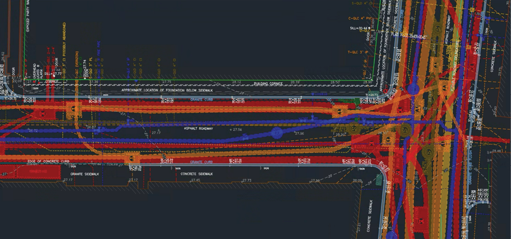
DGT Associates’ subsurface utility information integrates data from remote sensors, traditional utility locating technologies, and legacy utility information to provide a comprehensive map of the underground.
Integrating SUE/SUM early in the design phase changes that equation. By validating what lies beneath before breaking ground, teams can minimize risk, avoid costly redesigns, and build with greater confidence and clarity.
Gabriel Armas, a longtime DGT partner and client, strongly advocates integrating SUE/SUM into engineering workflows and early-stage design planning. With more than 12 years of experience in asset management and three years as Director of the Campus Facility Management Technology Association, he shared:
“Subsurface utilities are often out of sight but can’t be out of mind. Ignoring them invites project delays, late-stage design revisions, unplanned expenditures, and serious safety risks. Partnering with DGT brought critical visibility to what lies beneath the surface. Their thorough investigations and detailed mapping have provided a dependable foundation for design, helping us identify and resolve potential conflicts before they become problems. Whether working on infrastructure upgrades or new construction, the expertise of subsurface utility professionals has fundamentally improved how we plan and execute our work, especially on complex sites where accuracy is non-negotiable.”
Expanding Peer Review to Include Utility Experts
Peer reviews are a cornerstone of engineering quality control. Project owners routinely depend on civil design peer reviews to reduce risk and ensure compliance with the applicable laws, rules, regulations, and design standards. However, one critical perspective is often missing: the SUE/SUM professional. Despite their essential role in risk management and constructability, utility mapping experts are frequently left out of the process, leaving a significant blind spot in project planning.
Involving SUE/SUM specialists in peer reviews fosters cross-disciplinary collaboration and reinforces shared accountability across project teams. Their expertise in data confidence levels, detection limits, and mapping accuracy ensures that utility data is not only correctly interpreted but also properly integrated into design decisions. This is especially critical when working with lower-quality Level C and D data, which are often the inputs engineers rely on.
Involving utility experts early in the design process ensures that plans align with real-world conditions, helping to identify conflicts, avoid design errors, and minimize costly delays, rework, and liability during construction. By formalizing utility-focused peer reviews as a standard industry practice, firms can elevate quality standards, strengthen cross-disciplinary coordination, and reinforce the importance of subsurface data in achieving true engineering excellence.
Real-World Lessons from Insufficient Subsurface Foresight
Over the past 40 years, civil design technologies, land surveying practices, underground damage prevention programs, and construction methods for locating underground utilities have advanced significantly. Yet utility strikes and near-misses remain alarmingly common. Why? The answer is simple.
From small scale to big budget, any project can encounter setbacks when underground conditions are underestimated. Even with growing awareness of utility-related risks across the U.S., many civil infrastructure projects still move forward despite lacking sufficient subsurface insight. Designers often submit plans and construction specifications without a comprehensive understanding of site conditions, instead relying on risk-transfer language that shifts legal responsibility to contractors for locating and mapping underground utilities.
Too often, subsurface utility investigations are not conducted before the Notice to Proceed—the formal authorization for construction to begin—leaving little time to coordinate utility locating, relocation, or protection efforts. Even on projects that do engage subsurface utility professionals early in the design phase, it remains essential to verify whether conditions have changed between preliminary design and the start of construction, particularly when a year or more has passed. In many cases, insufficient utility mapping or the absence of subsurface peer review has contributed to avoidable delays, added costs, and unnecessary complications.
California’s I-405 Expansion
Rolled out in 2010, California’s I-405 widening project aimed to ease congestion through Los Angeles. Instead, it ran 55% over budget, ultimately exceeding $1.6 billion, and suffered significant delays due to repeated design changes and failures to identify key utility conflicts. A Metro report later highlighted “detailed underground utilities investigations” as one of the top lessons learned. More than a dozen utility lines had to be rerouted beneath Sepulveda Boulevard, and sections of the freeway were redesigned midstream to accommodate an unexpected 12×12-foot stormwater culvert.
Boston’s Big Dig
What began as a $2.8 billion plan to reroute Boston’s central artery overhead highway to an underground location grew into a $14.6 billion megaproject that ran nearly a decade behind schedule. A major factor in the overruns: project leaders ignored federal recommendations to conduct thorough SUE/SUM investigations. With Boston’s dense and aging 200-year-old infrastructure, this oversight led to major utility conflicts that forced mid-project relocations of critical systems, resulting in prolonged traffic disruptions, business interruptions, and soaring costs, most of which could have been avoided with proper utility mapping and review from the outset.
Making Utility Coordination a Design Standard
Every project operates under pressure: tight timelines, shrinking budgets, and growing complexity. In today’s environment of rising material costs, supply chain disruptions, and little room for mistakes, overlooking subsurface utilities is a risk no team can afford to take.
Incorporating subsurface utility coordination as a standard step in the design process can help teams reduce delays, minimize rework, prevent budget overruns, and avoid utility conflicts. This proactive approach not only supports better engineering decisions, greater constructability, and safer outcomes, but it also increases confidence in the plans delivered to construction teams.
Utility coordination shouldn’t be treated as an afterthought or a last-minute box to check. It must be recognized as a fundamental part of project planning. Including SUE/SUM professionals in peer reviews isn’t just best practice—it demonstrates a commitment to accuracy, accountability, and doing things right the first time. After all, when it comes to creating resilient infrastructure, what’s built above ground is only as strong as the foundation that lies beneath it.
Reach out to learn more about our SUE/SUM services and how you can leverage our peer review expertise: https://dgtassociates.com/contact
As Project Director for Subsurface Mapping at DGT, Michael A. Twohig is an expert in professional utility locating, mapping, and damage prevention, driven by a commitment to advancing safety standards across the industry. Bringing almost 40 years of experience from across the US, Australia, India, and Europe, Mike has worked on projects of varying scales and complexity, focusing his talents on integrating traditional utility locating procedures with land survey best practices.