My first exposure to retracing original GLO surveys was at, of all places, the Larch Mountain Honor Camp, located about 20 miles east of Vancouver, WA. The Washington Dept. of Natural Resources opened the Honor Camp in about 1957 to begin to build roads, fall snags, fight fires, and then re-plant trees. The camp was near the west edge of the “Yacolt Burn,” a major forest fire which was started on September 11, 1902, by a homesteader near Carson, WA on the Columbia River.
In 3 days, after being pushed by east winds, the fire had traveled over 40 miles northwesterly, ending near the little town of Yacolt when the wind finally subsided. About every ten years thereafter, another fire would re-burn large areas of the original fire, feasting on new brush and dead snags. The camp was manned by about 100 inmates, all of whom were “in on a bum rap” of course. I was assigned 2 inmates to help me locate new roads, locate section lines, etc. One was an architect and the other a lawyer, go figure!
I learned a lot about retracement from a couple of foresters at the camp. (see the January-February 2023 and the March-April 2023 two-part story “Improbable Corners I Have Come to Know” in the American Surveyor Magazine) Fast forward to the July-August 2024 copy of the American Surveyor Magazine and the “Tale of a Troubled Township”.
The following story reveals major differences between GLO procedures in the “Troubled Township” (1892) versus those in 1894. In 1892, William Bushey’s “survey notes” were turned in to the Surveyor General’s office in Oregon City. At that point, another deputy surveyor would be sent out to make an inspection and independent re-survey of, in this case, 7 miles of Bushey’s 1892 work in T10S, R7E.
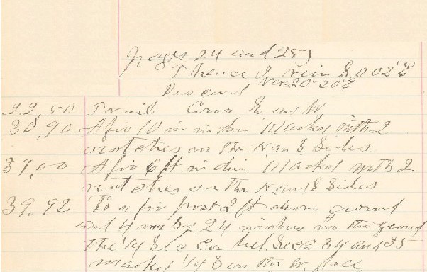
Fig 1a
The deputy assigned to do the inspection was Alonzo Gesner whose first contract in Oregon was in 1873. I have retraced Alonzo several times and found him to have the worst penmanship I’ve ever come across! (see Figure 1) That being said, retracing a fellow surveyor is a tricky business and one surveyor is sometimes reluctant to “bad mouth” the work of another. After reviewing Gesner’s work, the Surveyor General of Oregon approved Bushey’s 1892 survey and his notes and plat were filed in the public record.
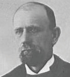
Fig. 1b Alonzo Gesner 1894
In 1893, the General Land Office decided to start using federal surveyors to inspect a deputy surveyor’s work. In 1894, Bushey was awarded the contract to complete the township boundaries of T11S, R7E and survey all the Section lines within. (see Figure 2) Contract 625, dated April 19, 1894, was for $1,300 and the rates for payment were $16.50 per mile for township lines and $16.00 per mile for Section lines. He also had to post a Bond for $1300 from each of two sureties, one of which was John Minto (who came over the Oregon Trail in 1845 to the Willamette Valley of Oregon) and the other was Alonzo Waln, the father of one of Bushey’s survey crew members.
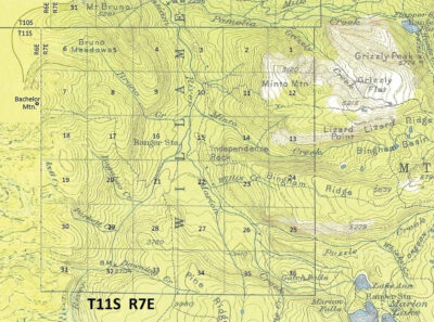
Fig. 2
When Bushey turned in his August 1894 field notes to the Surveyor General in Oregon City, they were then given to a federal surveyor named Thomas Gerdine, who was to make the field examination. In spring, 1895, Gerdine re-traced six Sections, being 14, 15, 22, 23, 26 and 27. They were all on relatively gentle terrain, mostly being east of the North Santiam River and containing the Minto Trail, located in 1874 by John Minto. (the town of Detroit was 12 miles to the west)
His exam disclosed a 100-foot shortage in northing between the southeast corner of Section 27 and the northeast corner of Section 15. That was enough to prompt the Surveyor General to notify Bushey that he needed to resurvey the exterior boundaries and the subdivisional lines of T11S, R7E all over again. Having no choice, Bushey turned in a complete set of notes for the entire township in the summer of 1896.
In reality though, on the ground he only “resurveyed” the line between the southeast corner of Section 27 and the northeast corner of Section 10, his “resurvey” consisted of merely picking up the 1894 corner stones and moving them “north” from 25 ft. to 75 ft. for 3 miles before tapering down to zero at the northeast corner of Section 10. Depending on the distance moved, he many times would chop the 1894 scribing off his BT (facing south) and re-scribe the same tree on the northern side, facing the new 1896 corner location, (see Figure 9).
In the case of the quarter corners on the east-west lines, he would move his stone north, half the distance that the section corner was moved. He scribed new BTs at most of these quarter corners. Since he was never going to be paid for resurveying work, I’m fairly sure that Bushey took one of his crew members along with a staff compass and chain and moved the corners northerly from 25 ft. to 75 ft. for 3 miles before tapering down to zero at the northeast corner of Section 10.
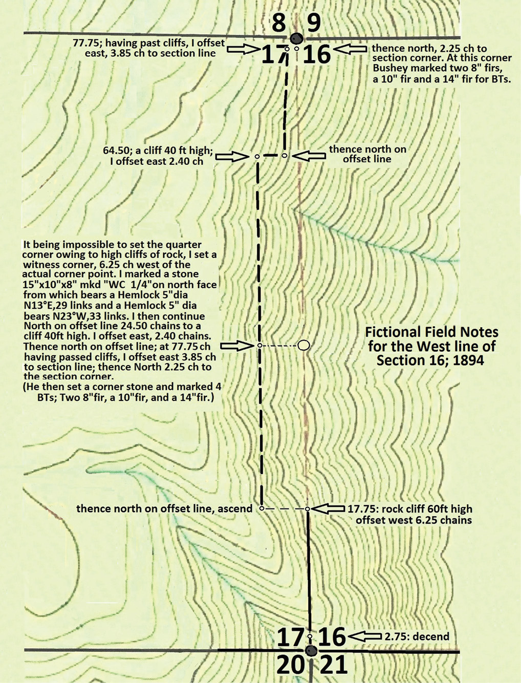
Fig. 3
The only other line he “re-ran” was between Sections 16 and 17. “Re-ran” is deceiving since he never ran that 1894 line in the first place, but instead made up fictitious notes that were so detailed that an examiner might defer from retracing such a line due to the apparent “ruggedness” of the country. (see Figure 3) Since Gerdine’s 1895 exam was mostly east of the Santiam, apparently no one looked at Bushey’s 1894 field notes west of the river. It would have been pretty embarrassing if the GLO examiners were to read about the big bluffs, etc (see Figure 5) and then see how in 1896, they had magically disappeared. (see Figure 4)
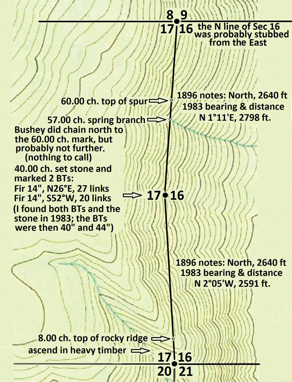
Fig. 4
When Bushey actually ran the line “north” from the southwest corner of Section 16 in 1895, the call at 8 chains (“top of rocky ridge”) was right on the money.! The quarter corner was then set at 40 chains and described. (In 1984 I found the stone marked just as his notes had called for. Bearings and distances to the BTs were right on, although their diameters were now 40” and 44”.) He continued “north” for about 20 more chains since he made “calls” to the “spring branch” and the “top of spur” which were accurate. (see Figure 4)

Fig. 5
He continued “north” to the Section corner but found that his “half mile” running north from the west quarter corner of Section 16 was about 2 ½ chains too long, but his notes obviously had to read 80.00 chains.! (see Figure 5 and 6) He previously had “stubbed” the northwest corner of Section 16, “West, 80 chains” from the northeast corner of Section 16 (see Figure 6).
It is very probable that Bushey continued running west from the northwest corner of Section 16, two miles to the Range Line. He had “walked” the north line of T11S, R7E when he initially set the section and quarter corners as he went west from the southeast corner of T10S, R7E in 1894. Near the southwest corner of T10S, R7E, he could look southeasterly and see a lot of gentle ground in the Bruno Creek valley below him which meant “easy line running”. If you look at a modern survey map (see Figure 6), any section line that is longer than 2700 feet was probably never run.
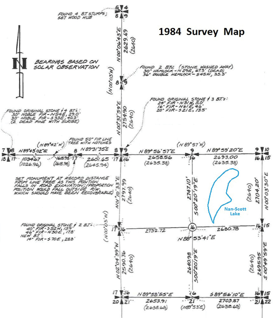
Fig. 6
In early 1897, Bushey had not heard anything from the Surveyor General in Oregon City about an approval of his 1896 notes. He is informed that it was too late in the year to do another exam, as if they hadn’t even seen Bushey’s 1896 notes. There were several letters back and forth within the GLO in 1897 that sounded like the left hand didn’t know what the right hand was doing! Finally in 1898, the Surveyor General sent “Examiner D.W. Kinnaird” to retrace 8 more miles of Bushey’s work, immediately north of Examiner Gerdine’s 1895 retracement.
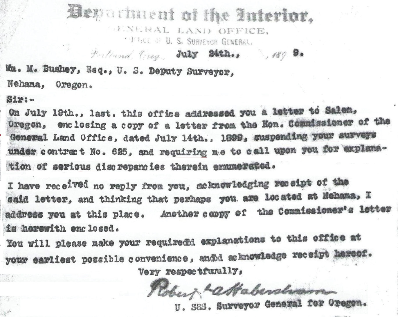
Fig. 7
Kinnaird independently surveyed the boundaries of Sections 10 and 11, as well as a mile between Sections 2 and 3. (see Figure 9) His scathing report on Bushey’s 1896 work (see Figure 8) was then sent to the Surveyor General of Oregon, Robert Habersham. After reviewing Kinnaird’s report, Habersham, on July 14, 1899, sent a letter to Bushey, but addressed it to him in Salem. After getting no reply, he re-sent the letter on July 24, 1899, to Bushey in Mehama. (He had addressed it to “Nehama,” but it found its way to Bushey anyway) (see Figure 7)
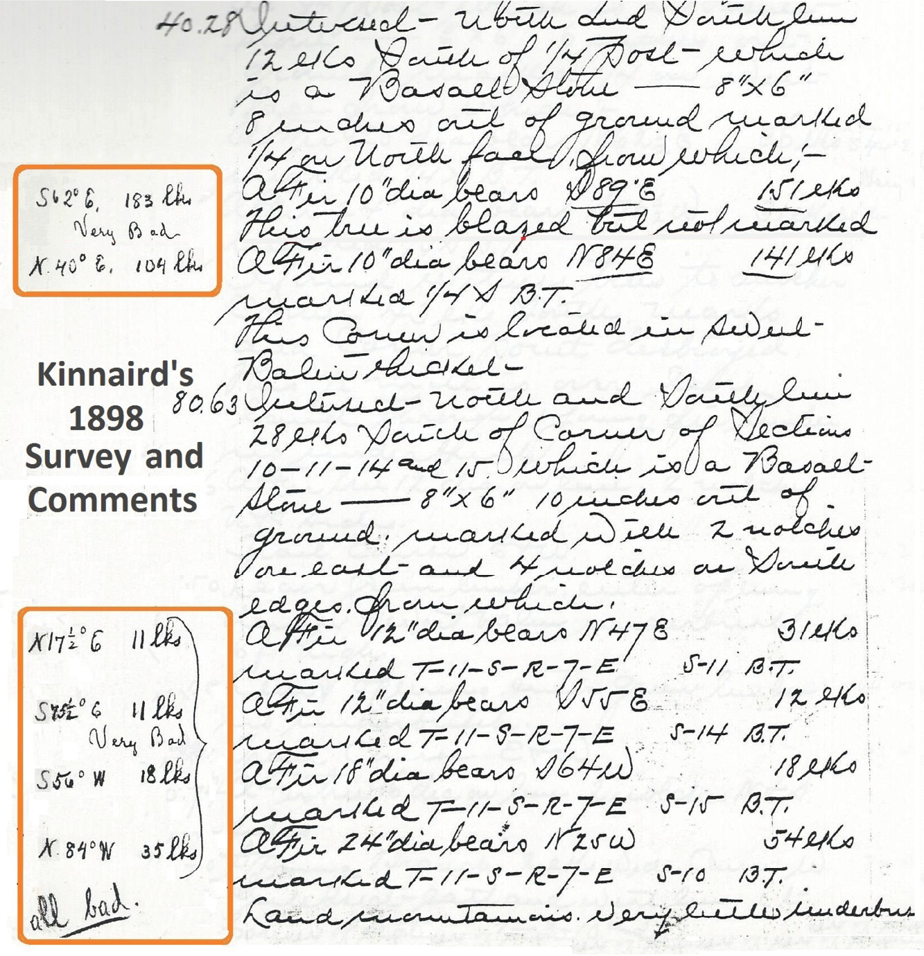
Fig. 8
Upon receiving Habersham’s letter, Bushey responded as follows: “in reply, I will say that after examining the matter mentioned in the letter of “Suspension of Survey”, dated July 14th, 1899, I am unable to account for the difference in the reports, unless one or the other of us has visited the wrong corners.”
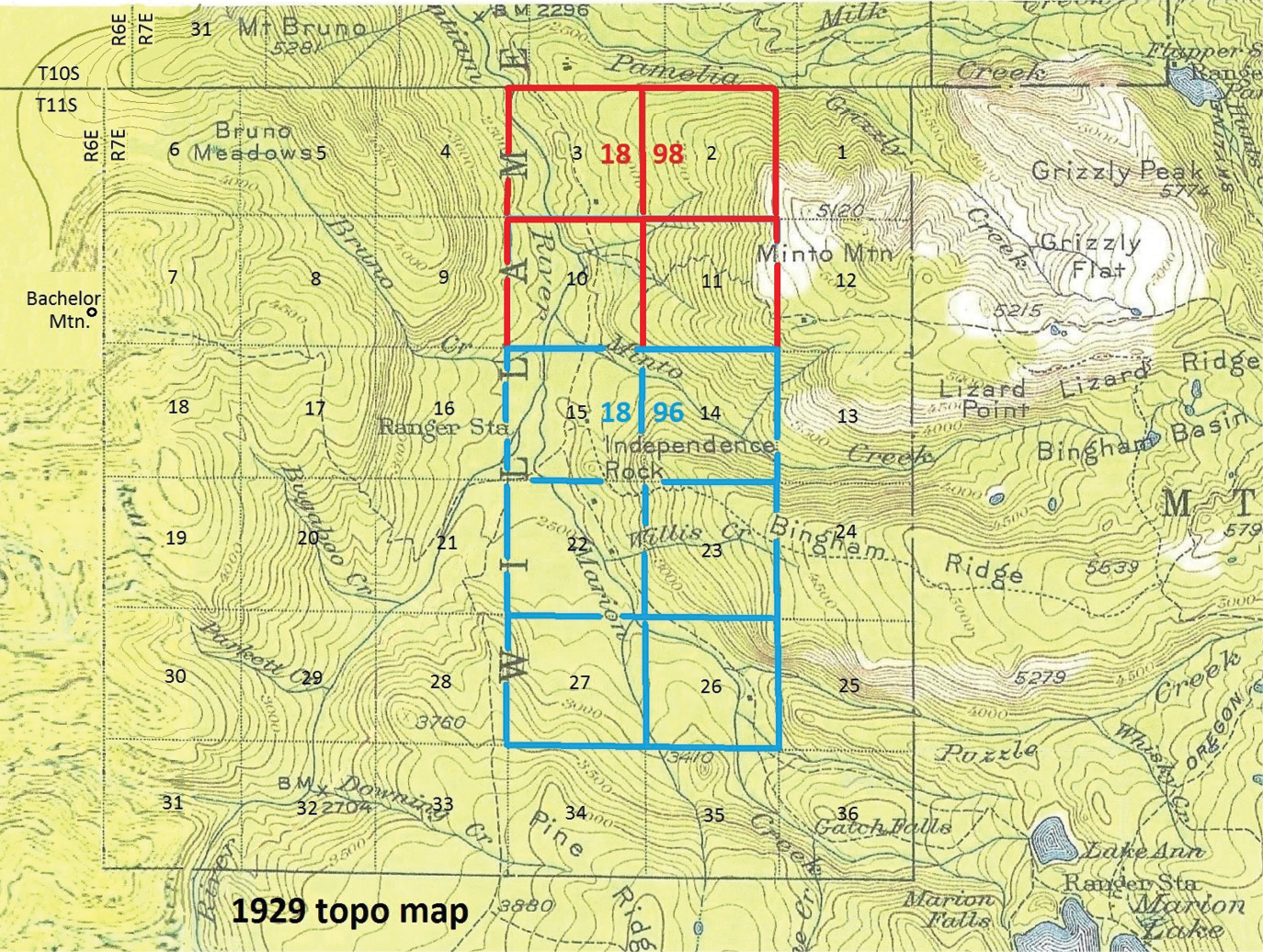
Fig. 9
On April 30th, 1900, the Oregon Surveyor General sends a letter to Bushey that says “we do not know which examiner has been chosen to examine your contract and are of the opinion no examiner has been instructed to make the exam this season. By then “Bushey had become a Supreme Court Judge (see Figure 10) and was fed up with the incompetence of the GLO and in early May, arranged a meeting “in the field” with Amherst. W. Barber, special examiner for the GLO, to “cuss and discuss” the differences between Kinnaird’s notes and Bushey’s. As Barber looked at several corners with Bushey, he could see that the stones and bearing trees were just as Bushey described them while Kinnaird’s notes were “out to lunch” for some reason. Finally on May 21st, the survey was accepted. (see Figure 11)
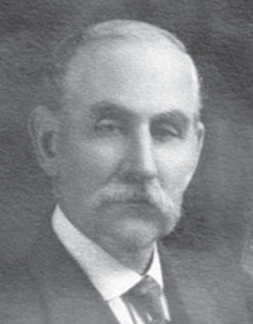
Fig. 10
I grew up in the little town of Idanha, OR which is about 3 miles east of Detroit, which in turn is about 50 miles east of Salem, OR. My dad was a “logger from way back,” starting in 1928 by horse logging, dragging out alder logs that summer for a neighbor, near Skamokawa, WA where his family had moved from New Hampshire in 1914. By the late 1930s, he had accumulated some logging equipment and started logging for small sawmills. He moved the family to Idanha in 1945.
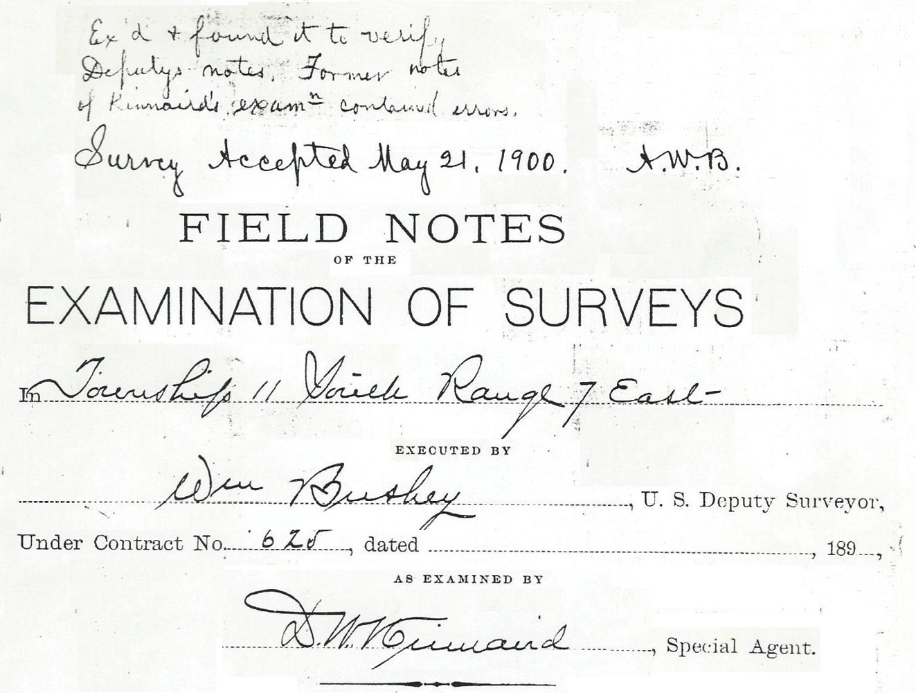
Fig. 11
I was born in Portland, OR in 1945, which is 50 miles north of Salem. In those days, the roads were poor, and my dad said he thought I might be rusted by the time we finally got back home from Portland, hence my nickname “Rusty.” (In Washington, I’m known as “Chuck,” but in Oregon, I’m known as Rusty by all my friends and relatives.) From Idanha, it is only 12 miles east to Marion Forks, where there is a Fish Hatchery and a campground, right in the center of T11S, R7E. I knew most of this country well, riding with my dad to various logging settings, going fishing in the summer and hunting in the fall.
In May of 1983, a surveyor from Roseburg, Oregon had put in a bid for a cadastral survey of a portion of T11S, R7E. W. M. The Forest Service had previously adopted a procedure to advertise for bids on cadastral surveys. Unfortunately, the Roseburg surveyor had never looked at the survey area in person (it was about 150 miles from Roseburg) and when he did drive up to recon with his survey crew, he immediately realized he could not do the survey for the amount he had bid and consequently defaulted.
I had driven around the survey area and had put in the next highest bid, so the Forest Service then awarded the job to me. The Roseburg surveyor had to pay the difference (about 5,000 dollars) between my bid and his to the Forest Service. (A few years later, the Forest Service, after hearing many complaints about the “bid system,” changed over to a “qualification-based system” where they would determine which firm was best qualified to do the survey project at issue.)
The “Forest Service surveyors” had done a “re-con” of the proposed survey area and the prospectus map showed the corners they had found and the corners that needed to be searched for by the contractor. (which was about 5 as I recall) At that time, I don’t believe the Forest Service paid any attention to “Line Trees”, but I had found about 3 of them anyway that were needed to control proportioning in several areas. (After some “cussing and discussing,” I convinced the Forest Service that recovering “line trees” should be paid for just like corners were.)
Since the 1984 survey mentioned above, I did quite a few surveys for Forest Service Ranger Districts in Washington and also in Oregon. (see the March-April 2016 issue of The American Surveyor) In the mid 1990s, I did a fairly large survey in the Detroit Ranger District, which was very enjoyable, being in my former “stomping grounds”. In about 1930, the Mt. Jefferson Primitive Area had been established, straddling the Cascade crest. It was about 16 miles north-south and 5 miles east-west, roughly centered on Mt. Jefferson, the second tallest peak in Oregon at 10,495 ft. It eventually morphed into the present Mt. Jefferson Wilderness Area.
In several places, the new boundaries are now along section lines. I volunteered to recover those corners involved thinking it might give me some “brownie points” in the future. The Forest Service was fine with that and supplied me with monuments, tags, and tree paint and I provided the field work. About 7 miles of the new boundary was in Township 11 South, Range 7 East and Township 10 South, Range 7 East, both surveyed by William Bushey.
By this time, I had acquired a Trimble sub-meter handheld GPS unit, which was about 3” x 6” x 1 ½” and easily fit in the back of my survey vest. Most of the “target corners” were in heavy timber, but about 20% were in open sky. At this point, I started to think that it wouldn’t be too hard to compute all the corners in the township. For example, I took my 1984 survey (see Figure 6) and tied the southeast corner of Section 16 and the north quarter of Section 17, rotated that course to the grid bearing and applied the grid factor to the distance.
Presto, I developed grid coordinates for 12 section and quarter corners. There were about six other surveys, done by others, that I converted using the same procedure. After my retirement in 2010, I had a lot more free time to look for corners, many times with my wife Sharon and other helpers such as our son Jeff and later, his daughter Beth. I also recruited 6 younger surveyors from the Battle Ground, WA area who hadn’t had any experience discovering 130 year old survey evidence in the woods. As for T11S, R4E, I have only 2 corners left to find and hope to do that this summer, before I turn 80.
C.E.“Chuck” Whitten graduated from Santiam High School in Mill City, OR in 1963. He then went to Oregon State University and graduated in Forest Engineering in 1967 and then was hired by the Washington Department of Natural Resources from 1967 to 1972, working on road location and surveying for timber sales. From 1972 until retirement in 2009, he was a project manager and vice-president for Hagedorn, Inc., a private surveying/engineering firm in Vancouver, WA. Since then, he has enjoyed retracing original GLO surveys. In June 2021 he was hired by the Marion County Surveyor in Salem, OR to recover section corner evidence in 6 townships devastated by the Beachie Creek and Lionshead Forest Fires of 2020.