Running a school district of 220,000 students is a large and complicated job, but one that is made easier for Hillsborough County Public Schools, the seventh largest school district in the country, with the help of DRMP’s GIS team.

Since 2023, DRMP has provided web mapping application development and data management services to HCPS’ Growth Management and Planning Department. What originally started as an initial project to create specific data viewing and reporting web applications for the department has evolved into providing a wide range of services and assistance, ranging from a product used by the public to tools custom-designed to support planning staff in their decision-making processes.
DRMP’s GIS Tool Simplifies Finding Your School Zone
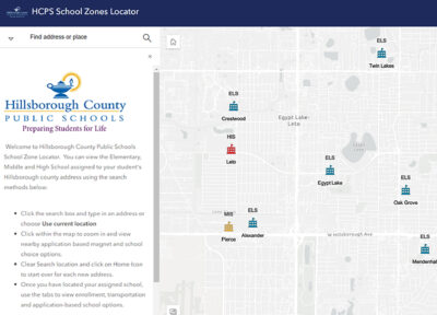
DRMP’s GIS team created and manages a public-facing School Locator web map to make it easy for students and families to determine their zoned schools. The tool combines county-wide address point data with HCPS school zone boundaries, providing clear, updated information that is useful not just for currently enrolled students but also the community at large.

The home screen of the Hillsborough County Schools Zone Locator Application displaying school locations in Tampa.
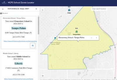
DRMP created the School Locator viewer with the user experience in mind. We considered what parents and guardians would need, offering quick links to resources, such as school choice, transportation, and enrollment. Each search within the School Locator tool links directly to the relevant school and provides the user with detailed information including the school’s address, map location, phone number, and link to the school’s website.

The HCPS School Locator Application displaying the zoned elementary and middle schools for the DRMP Tampa office address.
GIS Project Manager Mark Brown, GISP, and GIS Analyst Ravneet Kathuria, played key roles in designing the autofill functionality of the School Locator and keeping the address information up to date as new addresses are created county-wide every day. According to Mark, one of the largest challenges in creating this product was incorporating the functionality of returning not just the zoned schools for the current school year, but also the next year’s school zones for an address. Because of rezoning, school closures and newly opened schools, school zone boundaries need to be updated for each year.
Since its launch in July 2023, the School Locator has become a go-to resource, helping hundreds of thousands of users get the information they need with just a few clicks. The School Locator has been accessed over 289,000 times since its inception and is updated annually between school years.
Planning for Growth Using Geographic Data
In addition to the School Locator, our GIS team also handles student address geocoding for the Hillsborough County Growth Management and Planning Department. This involves updating a detailed point address layer for every student address in the county every 20 school days. By matching student addresses with county address point data, we help the Growth Management and Planning Department track enrollment trends and manage zoning boundaries effectively. This process is vital for understanding where students live and planning for future infrastructure needs. GIS is a lot of things, but it’s ultimately where geographic information and databases meet each other. Being trusted to manage and analyze student data is a big responsibility, but one that we take seriously. We know that each data point is a real student who will take a unique path through their time with the school district.

The DRMP GIS team (from left to right: Meaghan McCarthy, Kelly Marton, Ravneet Kathuria, and Mark Brown) after meeting with the HCPS Growth Management and Planning staff in downtown Tampa.
The GIS team is also working on a planning tool that will give the Growth Management Department instant access to critical data through a web application. This new tool will allow for on-the-fly report generation and data retrieval, which helps streamline the Department’s operations and make the information more accessible to HCPS employees.
Our GIS expertise also helps the Department evaluate how new housing projects will affect local schools. By estimating the potential number of students from new residential development projects, we help the Department plan for capacity and the need for new schools. This ensures new developments are thoughtfully incorporated into the community’s educational infrastructure.
With the expertise of DRMP’s GIS team, Hillsborough County Public Schools can manage the challenges of growth and planning more effectively. From helping families find their zoned schools to forecasting the impact of new housing developments, our GIS solutions are an integral part of making informed decisions that shape the future of education in the community.
Kelly Marton, GISP, serves as a GIS Project Manager for DRMP’s GIS Department. She began her career at DRMP in 2015 and has been essential in supporting the growth and diversification of DRMP’s GIS services.