By now, you’ve likely heard about Solar Cycle 25, the time when solar sunspot activity is highest—and GNSS signal reliability is at the most risk.
The current 11-year solar cycle began in 2019 and is anticipated to peak between now and 2026. In May, there was a significant solar storm that maxed out the Kp index (more on this later), the largest in over 20 years, and it directly affected GNSS signals in North America. These impacts were felt across the U.S. That said, Solar Cycle 25 was relatively modest compared to some recent cycles, such as 23.
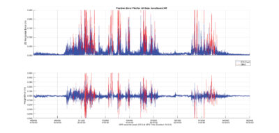
Figure 1: Looking at this Northern Alberta GNSS receiver on a 1.8 km RTK baseline, we see that when the ionospheric disturbance begins around 18:00 hours UTC on May 10, with significant “noise” seen in the position solution. While a GNSS receiver struggles to maintain an RTK-fixed solution mode, RTK-fixed operation drops below 91% (18:00 May 10 through 10:00 May 12, UTC), and even then, outliers are seen in the RTK-fixed position.
Unfortunately, solar events are largely random, intermittent and difficult to predict and plan for. As the solar cycle peak draws closer, the frequency and potentially, the severity of events will as well. In some cases, positional accuracy degradation as a result of a solar disruption can reach as much as a meter. For those activities that require centimeter accuracy, that’s unacceptable.
The upcoming solar maximum will likely present some challenges for GNSS-reliant operations, particularly those with high precision requirements—but there is no need to panic…just prepare.
What to Know
Ionospheric activity is correlated with the solar cycle. Towards the peak of the cycle, GNSS signals experience more delay through the ionosphere. However, activity in the ionosphere can cause additional impact to GNSS users. Geomagnetic storms originating from the sun impact GNSS users at high latitudes in both the Northern and Southern Hemispheres. These storms rarely impact equatorial regions. However, equatorial regions have their own ionospheric phenomenon.
Geomagnetic storms create large disturbances in the atmosphere, as demonstrated by the event in May. Coronal mass ejections (CME) are more frequently emitted from the sun during the peak of the solar cycle. They contain plasma with a magnetic field. If the CME is directed at the Earth, it can cause a geomagnetic storm on Earth around a day or more after it leaves the sun. The plasma is guided by the Earth’s magnetic field to the poles, where it interacts with the ionosphere and causes instability. This can impact the GNSS signals as they travel through the ionosphere, resulting in high rates of change in delay. While temporary, event timing and severity are unpredictable.
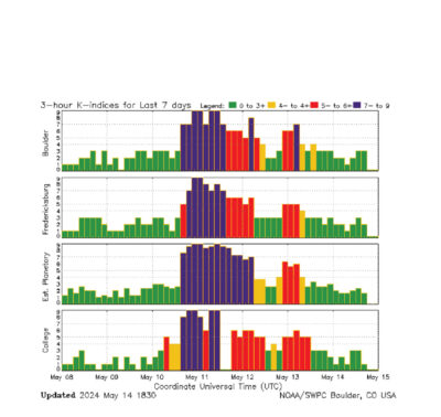
Figure 2: The Station K indices show the fluctuations in the magnetic field, tied to specific geographic locations. The indices have a range from 0 to 9 and are directly related to the maximum amount of fluctuation (relative to a quiet day) in the geomagnetic field over a three-hour interval. Source: https://www.swpc.noaa.gov/products/station-k-and-indices
During these events, the phase measurements can become noisier, the signal strength can fade, and the ionospheric temporal and spatial gradients (how the ionosphere changes with time and distance) can increase. Even multi-frequency/multi-system RTK position solutions can be negatively impacted. At an extreme, the receiver may no longer deliver positions at full accuracy.
Figure 1 is a good example of the effects of a high-magnitude storm on an RTK-Fixed position solution.
As opposed to a geomagnetic storm, another type of event is seasonal ionospheric activity, a familiar condition for equatorial-based countries, such as Brazil. In this region, ionospheric activity has an eleven-year solar cycle, a seasonal component, and a daily cycle. The equatorial ionospheric anomaly results in ionospheric scintillation from September through March, after sunset for 3-5 hours each night. These are more predictable than storm-based effects.
NOAA’s Space Weather Prediction Center (SWPC) relies on the Planetary K-index (Kp), to characterize the magnitude of geomagnetic storms. The planetary Kp-index is a globally averaged indicator of the worldwide level of geomagnetic activity that, according to SWPC, is derived by calculating a weighted average of K-indices from a predetermined network of geomagnetic observatories, the official Kp network. To learn more, I recommend visiting this site: swpc.noaa.gov/products/planetary-k-index
For our purposes, the Kp index is an indicator of disturbances in the Earth’s magnetic field and, therefore, a way for SWPC to determine whether geomagnetic alerts and warnings need to be issued for users who are affected by these disturbances.
Figure 2 from the SWPC site is an example of a K-Indices captured during the May 2024 geomagnetic storm.
So now you know the science behind the predictions, what does that mean to your surveying activities?
Managing Solar Variability
GNSS users can be prepared for possible solar disturbances to GNSS-enabled systems through prudent planning and taking advantage of ongoing improvements in technology.
Here are a few ways to make sure you’re prepared for any solar event.
Multi-Constellation Access
While the effects are unpredictable, modern receivers are much better equipped than in the past solar cycle thanks to technology advances. Ionospheric mitigation features have been added and improved upon in GNSS receivers over the past three solar cycles, with frequency independence just one such adjustment. Using more satellites across multiple independent satellite systems (e.g., GPS, GLONASS, Galileo, BeiDou) reduces the chance of errors from solar disturbances. It allows the receiver to deweight or eliminate satellites that are severely affected by ionospheric disturbances or other error sources, and still have a significant number of satellites to use in the position solution, improving overall positioning accuracy.
Advanced Algorithms
These software algorithms used in modern GNSS receivers are able to help mitigate the effects of ionospheric disturbances on satellite signals. They work by estimating parameters related to the ionospheric impact on each individual satellite signal and then adjusting the positioning calculation process to account for and compensate for the estimated noise/errors introduced to each satellite’s measurements. This allows the receiver to still make partial use of satellites experiencing some ionospheric noise, rather than discarding them, improving overall positioning accuracy during disturbed conditions.
Trimble® IonoGuardTM, for instance, is purpose-built to counteract the effects of Solar Cycle 25. It has been shown to significantly improve positioning performance compared to older receiver software. This technology is designed to optimally process the GNSS measurements in the position engine while also improving signal tracking of disrupted GNSS signals. It is an additional layer of protection that makes precise GNSS measurements possible under the most challenging atmospheric conditions, increasing the likelihood of uninterrupted and robust positioning data around the clock. During recent solar storm events in Brazil, Peru and northern Sweden, the improvement in both horizontal and vertical positional accuracy using IonoGuard1was significant.
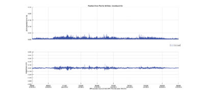
Figure 3: Looking at the Northern Alberta GNSS receiver on a 1.8 km RTK baseline, the GNSS receiver on the same antenna running IonoGuard technology reflects a dramatic improvement in positioning performance. The system now maintains an RTK-fixed solution mode throughout the entire geomagnetic storm.
Compare the position error graph (Figure 3) to the one earlier (Figure 1) from the same location in Northern Canada during the recent storm. Figure 3 shows when IonoGuard is enabled. When compared with Figure 1, the benefits are clear.
Contingency Planning
Have contingency plans that emphasize operational continuity and productivity in place to help minimize impacts and keep work moving forward even if primary GNSS-based operations face challenges due to ionospheric disturbances..
Some example contingency plans mentioned could include increasing the number of reference stations/base lines for RTK applications and for those using autonomous equipment, have alternative manual processes to fall back on for redundancy.
Resource Ready
Much like a jobsite, knowing your environment and how it changes over time is fundamental to Solar Cycle 25 preparedness—all without getting caught up in hysteria over every minor storm warning. There are a few excellent and reliable sites that provide easy and quick situational awareness of events anywhere on Earth.
The first is the NOAA Space Weather Prediction Center2, which has geomagnetic storm alerts and forecasts. It has an easy-to-interpret, color-coded chart of magnetic storm levels and provides geomagnetic storm alerts and forecasts. Users can even sign up for email notifications of storm warnings. An example of an alert might be: a coronal mass ejection (CME) left the Sun on June 1 and may begin to impact Earth’s atmosphere on June 4.
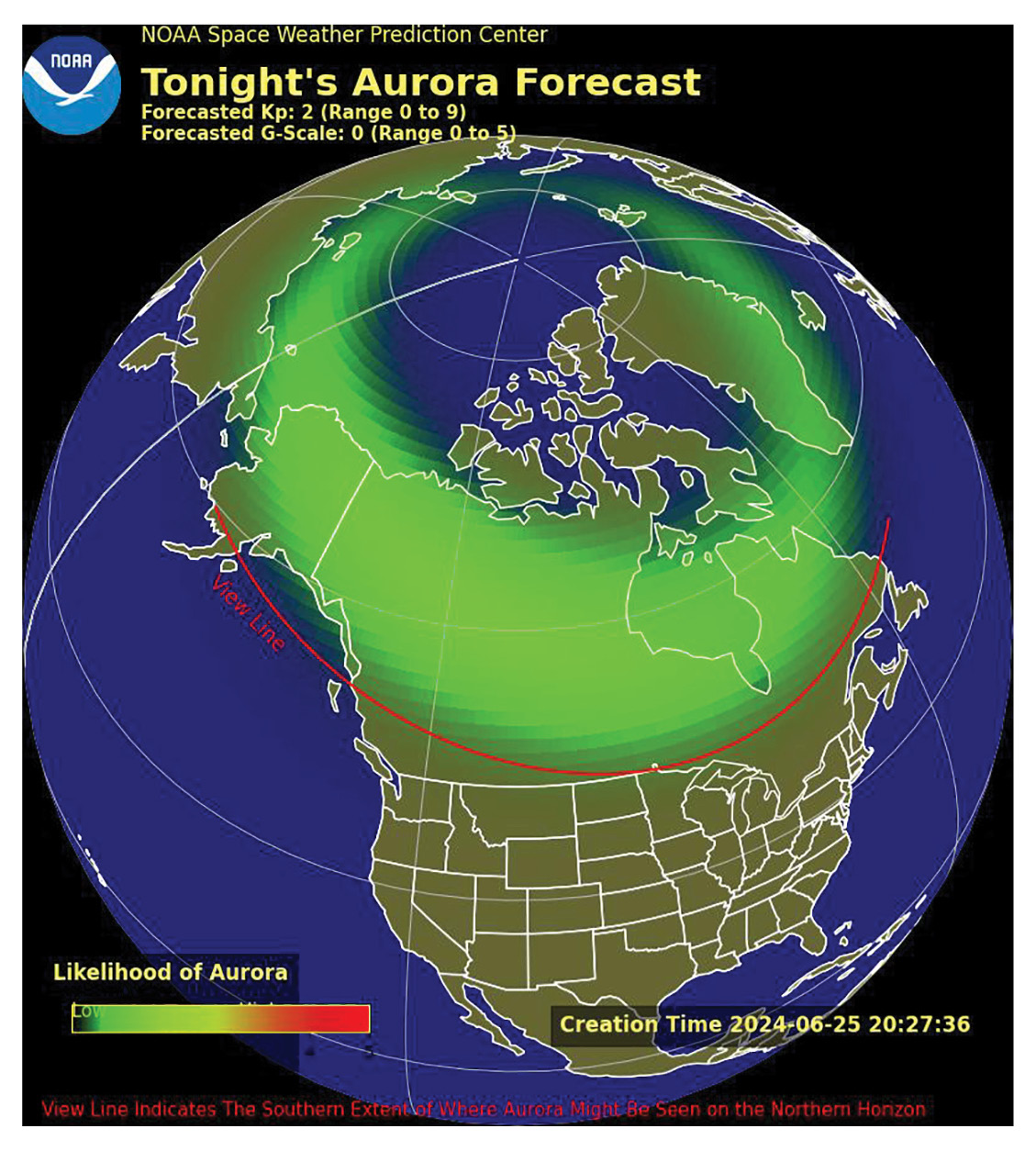
Figure 4: NOAA’s Aurora Dashboard Source: Aurora Dashboard (Experimental) | NOAA / NWS Space Weather Prediction Center
The NOAA Geomagnetic Dashboard3 shows real-time auroral activity maps and plots of solar wind properties, though it has complex scientific visualizations. Also, Spaceweather.com provides daily updates and metrics on solar storms and the resulting geomagnetic and ionospheric effects, though the site contains advertisements.
Another easy to use resource is Trimble’s free online GNSS planning tool, www.gnssplanning.com, which provides an overview of current and forecasted conditions. Trimble has established a global ionospheric measurement network that allows users to plan ahead and avoid working during times where there is higher probability of disturbance. The site includes options for satellite availability planning, where you can choose your location and date/time in the future (based on published almanacs) to plan the best satellite availability. It also allows you to view TEC and scintillation models that are created by the Trimble RTX server software.
Preparation is Key
The potential effects of Solar Cycle 25 on GNSS signals, including accuracy and availability, are real, but for most surveyors, the solution is straightforward and manageable.
Now is the time to pay attention to potential impacts by tracking solar activity, leverage modern technology improvements, and have backup strategies in place to minimize productivity disruptions.…and then plan accordingly.
Dr. Stuart Riley is the Vice President, Technology—GNSS at Trimble.
1 oemgnss.trimble.com/en/technologies/ionoguard/trimble-ionoguard-protecting-from-disturbances
2 swpc.noaa.gov
3 swpc.noaa.gov/communities/aurora-dashboard-experimental