Maysville, Kentucky, USA (August 19, 2024)–Today Carlson Software has released its new version 2 of PhotoCapture, bringing advanced features and greater flexibility to aerial imaging professionals, surveyors, engineers, and anyone else processing highly accurate drone data.
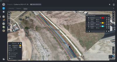
The new user interface in Carlson PhotoCapture V2.
The new Photocapture Standalone Basic features a new windows-based foundation with simple installation, a simpler, sleeker, faster user interface, overlap adjustment, more available projections, and faster overall photogrammetry processing speed.
Carlson PhotoCapture Standalone Advanced adds the Survey Canvas, which allows manipulation of processed point cloud data such as stockpile volume calculations, the drawing of linework, surfaces, and much more, all within the PhotoCapture program itself. New to the PhotoCapture Survey Canvas in version 2 are the View Site feature for viewing changes on sites over time, as well as the ability to remove moving objects.
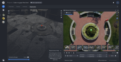
LiDAR colorization in Carlson Photocapture Standalone V2 Advanced.
PhotoCapture Standalone Advanced also now offers LiDAR colorization and processing, allowing the integration of LiDAR and photogrammetry data. Drawing on the strengths of each technology, this new feature creates more accurate and more visually appealing point cloud outputs.
Carlson’s PhotoCapture Web version remains, offering an entirely online solution utilizing cloud computing for processing power and featuring all the functionality of Carlson PhotoCapture Standalone Advanced, but priced as-you-go by the photo and LiDAR data you upload.
Learn more about Carlson PhotoCapture on the product webpage here, start a 14-day free trial of PhotoCapture (Web) here, or locate your local Carlson Representative or Dealer here.
About Carlson
Founded in 1983, Carlson Software Inc. specializes in CAD design software, field data collection, laser measurement and machine control products for the civil engineering, surveying, GIS, construction, and mining industries worldwide, providing one-source technology solutions for the entire project cycle. Carlson Software is headquartered in Maysville, Ky., U.S.A., with branch offices in Boston, Mass.; Almere, The Netherlands; Brisbane, Australia; Ottawa, Canada; and York, England.