I was fascinated by the February 2024 conviction of someone in Michigan who had purposely diverted a river—by hand. It took about a year and a half, but the National Park Service (NPS) located and successfully sued someone they believe acted alone in digging a new outlet for the Platte River into Platte Bay on Lake Michigan and moving rocks to build a dam to keep that new channel in place.
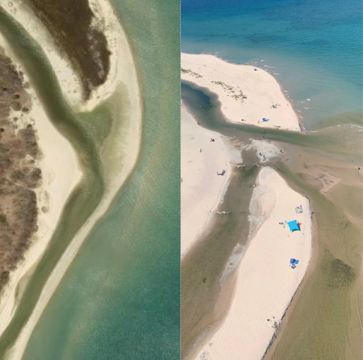
Before, left, Google Earth. After, right, NPS
The convicted fisherman says he happened to be the only one on the scene with a shovel, that others have also tried to keep the shifting sandy outlet open for boats and fish. He is one of many people who had been unhappy with the decision by NPS to stop issuing permits to the Michigan Department of Natural Resources (DNR) to dredge the river’s mouth at the lake. DNR had previously deposited dredging spoils from the river onto the beach, which is less expensive than hauling the spoils away. But the location at Sleeping Bear Dunes National Lakeshore means that NPS has the last say in establishing environmental and jurisdictional protocols.
Lack of dredging since 2017 resulted in the river’s outlet silting in, forcing portage of anything but the smallest boats and kayaks and challenging coho salmon and steelhead trying to swim upriver to spawn. Photos of the scene before and after August 2022 show the dramatic effects of the resolute fisherman. There are arguments on both sides about the end result of the new opening, which has washed out wider and deeper, but also drained large amounts of water from upstream wetlands while depositing debris and sand into the Lake.
My surveyor’s mind wandered off in other directions. What if, instead of being within a national park, this change in the river mouth’s location had been along privately owned lands? Examining aerial photos, this alteration clearly falls into the category of sudden and avulsive rather than slow and imperceptible. If ownership on the two sides of the former river location happened to be the same, perhaps no big deal.
But if ownership was not the same? The first worm wriggling out of the can is the general rule that private boundaries are fixed in the location where they were just before the avulsion. That applies whether the called-for dividing line is along the bank of a water body or along its thread (equally distant from both banks).
The second worm out of the can is more of a snake. We are still looking at different owners on each side of the now altered boundary. If one of those affected owners is happy with the change, then the other is left to struggle alone in finding out who was responsible for the unwanted change for any possible redress. There will be no help from title insurance because anything affecting rights and interests that arises after closing on the purchase is excluded from policies. Further, there are numerous policy exceptions relating to water even without nefarious activity. Changes in water boundaries, flooding and drainage from uphill owners, State and federal rights to regulate water bodies: these are all standard exceptions from title policy coverage. That leaves the unhappy owner with the burden of locating and prosecuting the person or entity that caused the problem for possible compensation in loss of property value.
This does happen. Early in my career, a bridge carrying a county road over a creek in central New Jersey was “rehabilitated,” meaning it was rebuilt with its piers at a different angle to the creek. That realignment affected the flow of the water, the thread of which formed the boundary between private lands immediately downstream. The question became whether the erosion resulting from the change in flow was “sudden” or “gradual.” It is true that at first the alteration in the banks might have been considered gradual. But within two years the creek’s location was very clearly very different from where it had been before the bridge alteration. Is two years “sudden”? The court sidestepped, dismissing the case in favor of the county responsible for the bridge and its reconstruction. The denial of compensation to affected property owners cited the county’s higher responsibility for public safety and public benefit relating to the bridge and road. Lacking funds to appeal, the property owners went away mad.
In the present real and hypothetical situations, numerous changes caused by the new river outlet could impact many sites. Those lowered river levels can affect agricultural use for irrigation and other commercial use. Changes to wetlands impact flood control as well as habitat for flora and fauna. The inevitable drainage of point and non-point pollutants into the river will be less diluted. What about the overall level of the aquifer—will private wells be impacted? Maybe we can’t consider everything everywhere all at once, but the blinders should come off in our own decision-making.