It was with great interest to read Knud E. Hermanson’s last Article 11 in the Missouri Surveyor, a quarterly publication of the Missouri Society of Professional Surveyors, in which Mr. Hermanson addressed several issues dealing with deficiencies in student education at Universities across America.

The article was timed well for a response with the newly approved Land Surveying and Geomatics Bachelor’s Degree Program at SIUE. The new program was developed to addresses those deficiencies mentioned in Mr. Hermanson’s article, and more.
The new program was also built around the exam specifications described in the NCEES Surveying Sample Questions and Solutions Booklet for both the FS and PS Exams.
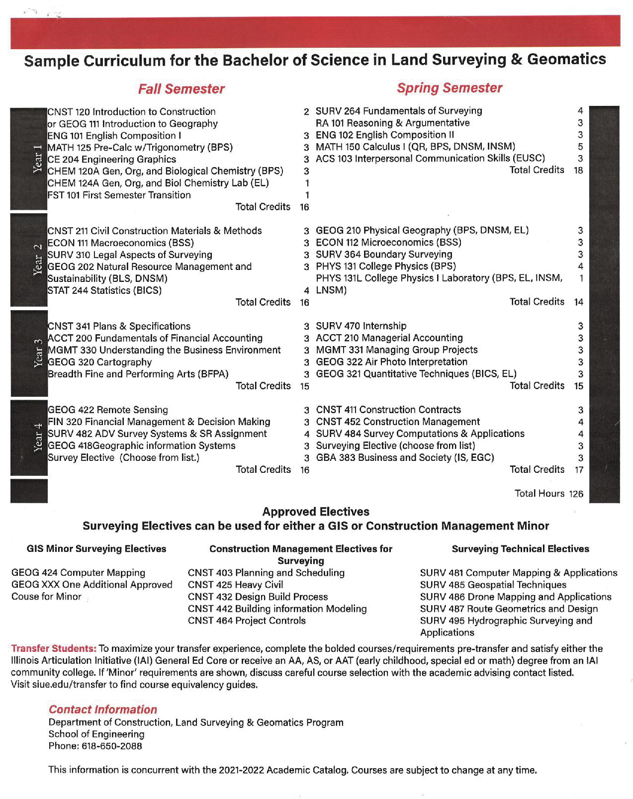
This article was prepared to compare the new curriculum in Land Surveying and Geomatics Program coursework at SIUE to the knowledge areas specified in the NCEES FS Exam, and to illustrate the comprehensive approach of the program in addressing all areas of knowledge needed to successfully pass the FS exam and to better prepare the graduate on his or her journey through mentoring under a licensed surveyor to become a well-qualified licensed surveyor and geospatial professional.
The coursework as shown in the Sample Curriculum for the new program at SIUE covers all sections of the NCEES FS exam specifications which includes, but is not limited to the following:
Section 1
Surveying Processes and Methods
16-24 Questions
- This section covers Instrumentation, GNSS/GPS, Control surveys, Accuracy standards, Cadastral, PLSS, Boundary, Topographic, Construction, Land Development, Field Records, and Data files.
- Coursework associated with this section is Surv 264, Cnst 415, Surv 482, and Surv 484 in the sample curriculum.
Section 2
Mapping Procedures and Methods
14-21 Questions
- This section covers Mapping concepts, Plats, Alta, Topographic, CAD, BIM, GIS, Digital Terrain Model, Photogrammetry, Remote Sensing, UAS, Drone, Analysis and Processing.
- Coursework associated with this section is Geog 111, Ce 204, Geog 210, Geog 320, Geog 322, Geog 418, Geog 422, Surv 482, Surv 484 and Surv 486 in the sample curriculum.
Section 3
Boundary Laws and Real Property Procedures
19-29 Questions
- This section covers Public Records, Descriptions, Common Law Principles, Easements, Conveyances, Metes and Bounds, PLSS, Riparian, Sources of Law, Encumbrances, Real Property.
- Coursework associated with this section is Surv 264, Surv 310, Surv 364, and Surv 495 in the sample curriculum.
Section 4
Surveying Principles
13-20 Questions
- This section covers Basic Surveying, Geodesy, Applied Geodesy
- Coursework associated with this section is Surv 264, Surv 482, Surv 484, and Surv 485 in the sample curriculum.
Section 5: Surveying Computations and Computer Applications
17-26 Questions
- This section covers Coordinate Geometry, Traverse, Closing and Adjustments, Leveling, Least Squares, Area, Horiz. and Vert. Curves, Volumes, Spreadsheets, and Graphs.
- Coursework associated with this section is Math 125, Math 150, Stat 244, Surv 264, Surv 310, and Surv 484 in the sample curriculum.
Section 6
Business Concepts
11-17 Questions
- This section covers Project Planning, Safety, Liabilities, Contracts, Supervision, Project Documentation, Ethics and Communications.
- Coursework associated with this section is RA 101, Eng 102, ACS 103, Econ 111, Econ 112, Acct 200, Acct 210, Fin 320, GBA 383, Cnst 403. Cnst 411 in the sample curriculum.
Section 7
Applied Mathematics and Statistics
10-15 Questions
- This section covers College Mathematics, Probability and Statistics, Measurement Sciences and Quantitative Reasoning.
- Coursework associated with this section is Math 125, RA 101, Math 150, Stat 244, and Surv 484 in the sample curriculum.
The coursework listed in the Sample Curriculum with its encompassing 126 credit hours shows how extensive the study is in Land Survey, Business, Computations, Mathematics, Geography, Geospatial, and related sciences.
It is important for the Survey Professional to understand that, with the technological advances and expanding geospatial sciences, Surveyors must embrace expanded educational training.
Design professions across America require Engineers, Architects, and Structural Engineers to have a bachelor’s degree to become licensed in each state. There is even a push to require a master’s degree in certain areas of Design.
The Land Surveyors in Illinois embraced the bachelor’s degree requirement in 1989 by legislative action. Since then, the Land Surveyor has reached parity with the other Design Professionals in respect, income, and opportunity. The current pass rate nationally for first time test takers of the NCEES FS exam is around 60%, with current Surveying students at SIUE having a 70% +/- pass rate. The goal of the new program is to increase that pass rate among the graduates taking the FS within 1 year of graduation. It is also the intent of the program administrators, to monitor the pass rate data and share with industry in future articles concerning education in the surveying profession. The Land Surveying and Geomatics graduates and successful Licensures in Land Surveying now have additional career pathways that were not available in the past. My hope is that it is clear that to become a Licensed Professional Surveyor across America, significant coursework is needed (actually required) to be prepared for the national test for licensure. The Bachelor of Science Degree in Land Surveying and Geomatics at SIUE should be considered no matter what state you live in, for preparing for the Land Surveyor’s exam. The coursework prepares the student to be licensed in any state across America, based on their educational requirements, giving graduates the flexibility to seek career paths in Surveying and Geospatial Sciences across the nation, increasing the future Surveyors option of location, parity with other design professions, salary, benefits, and culture.
In a final note, education is but one step in the Professional Land Surveyor’s path to licensure. The mentoring and practical experience component carries equal weight in that journey to licensure as a Professional Land Surveyor.
I truly hope that this article is read in a positive light for which it is intended. The Surveyor of the past has always had to adapt to changing technology in the tools that we were given, for measurements in the field and the final product prepared in the office. The fact that the Surveying profession today provides so many other career pathways beyond land surveying itself requires an increased focus on expanding surveying education coursework which we have developed at SIUE over the last 15 years and look forward to continuing to provide education for the Surveyor of tomorrow.
David J. Sherrill PS, is Program Director Land Surveying and Geomatics Southern Illinois University Edwardsville.