Millions of mosquitoes, quick fixes with buckets and cloths and emergency chocolate—it was a journey to remember
In the historical era of expeditions, simply reaching the unknown and dangerous destinations was usually one of the biggest challenges—if not the biggest. Scientific research was also carried out but the exploration of the unknown was perhaps the most important motivation for going. The modern day expeditions are usually very focused on science. The destinations are still remote and dangerous, and though transportation has gotten much easier, the challenge of delivering top scientific results in the high arctic is something that requires the right people, training and attitude. This story of millions of mosquitos, close muskox encounters and coming up with an emergency solution to get freshwater for the camp highlights the fact that expeditions in the modern times are still adventures that ask resilience and improvisation skills.
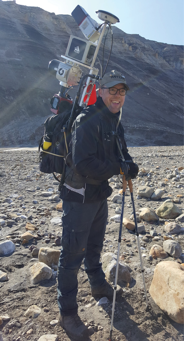
On a hike up to a plateau on Axel Heiberg island in July 2019. Akhka-R4 backpack lidar system provides an efficient survey tool to map terrain topography in high resolution.
Journey begins
Like academic endeavors often are, this is a story long in the making. In 2019 I got an opportunity to join a Canadian-US team for field work in the archipelago of the Canadian High Arctic. I have been lucky enough to have been in that Inuit territory twice before; 2016 and 2017 on Devon Island, the largest uninhabited island on the Earth, studying land formations in and around the Haughton impact structure and close to the ice cap in the east of the island. This time I got to get a bit further north though, all the way up to Axel Heiberg island—in Inuit language Umingmat Nunaat in Qikiqtani region, Nunavut, Canada.
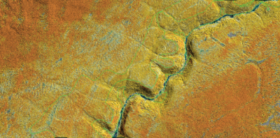
Snaking the terrain to capture the details. Backpack mobile lidar trajectory shown in green on top of the reflectance colored terrain data.
The story actually begins back in 2014 when I was contacted by a laser scanner distributor for a request to rent an instrument for a U.S. based planetary researcher. We got in contact, and made an agreement to lend them one of our terrestrial laser scanners. It was done on the condition that we got to join the team for a field study in Saaremaa, Estonia to scan the Kaali meteorite impact structure with a backpack scanner we had developed just a year earlier. That collaboration with Mike Zanetti (now NASA) brought me in contact with the planetary research team from the Institute for Earth and Space Exploration, University of Western Ontario, Canada, and later with scientists from University of British Columbia (CA), Arizona State University (US) and Simon Fraser University (CA). The other members of the 2019 expedition were Gordon ‘Oz’ Osinski (WU), Mark Jellinek (UBC), Shawn Shartrand (SFU), Anna Grau Galofre (ASU), Shannon Hibbard (WU), Chimira Andres (WU) and Etienne Godin (WU).
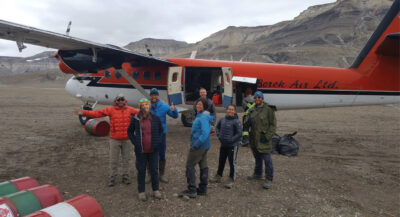
So eventually in the end of June 2019, after months of planning and numerous remote meetings with the team, I packed my backpack laser scanner equipment and personal gear and flew 29th June from Helsinki, Finland to Ottawa, Canada, where I met the rest of the team at the airport the next morning. The night in Ottawa was a bit restless as my gear was left behind in Toronto, but fortunately they arrived at the hotel in the morning hours. The flight route from there took us first to Iqaluit, then on a turboprop via settlements in Clyde River, Pond Inlet, Arctic Bay all the way to Resolute on Cornwallis island. On Cornwallis Island, the Polar Continental Shelf Program of Natural Resources Canada runs a base to support logistics in the Canadian High Arctic to support research and other activities. When finally landing there one knows that it’s a long way to afar.
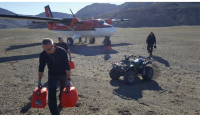
Unloading the cargo from the plane. These small ATVs provide a handy means of travel, usually we could do day trips 25-30 km away from the camp. Climbing two times on top of those 450 m high plateaus seen in the background to reach study sites on top with all the laser equipment, water and food for a day, making several hours of scanning and hiking back to the camp was an experience of its own!
PCSP base provides research teams accommodation, catering services and invaluable logistical support to reach far away camps and study sites all across the vast span of Arctic desert islands. In the storage hall, each team doing long term research in the region has their own cage room to store camping and field gear and long preserving desiccated food supplies. Fresh food was freighted for the season, and collected from the PCSP storage along with ATV’s for transportation, gasoline and generators for electricity, and natural gas for stove. Fetching bear bangers, whistles, guns and briefing to be ready for possible encounters with fearsome polar bears was also on the list of activities, completed with training with live rounds at the camp on the first evening on Axel Heiberg island. But that was a bit later.
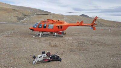
Sites beyond a hike, climb or ATV ride were reached with a helicopter operated by (now late) Universal Helicopters, flight hours generously funded by Oz’s research grant. We had four helicopter days during the campaign, so the sites to visit were carefully selected and prioritized. At the front lies Akhka-R4 lidar backpack that was used for mobile laser scanning of the permafrost and periglacial landforms on various sites on Axel Heiberg island. To the right the GNSS base station used for correcting the lidar positioning data, camp generator and radio mast are to be seen.
Before we got off to the field, we had an opportunity, thanks to bad weather further north, to celebrate Canada day on 1st of July at Resolute with the local community in a pretty decent barbeque fiesta! The place is located a few kilometers away from the PCSP premises, so we drove there enjoying the ride on a pickup bed. We also got to witness a motorcade driving by the community hall to celebrate the event. And the weather was just perfect for chilling out with the welcoming people. In the evening of the day we gathered in the living room of the PCSP Martin Bermann complex for the last emails, satellite images and briefing on the field plans for the expedition and the logistics of the flights. And finally the next day it was time to jump the last leg to the destination with a reasonably sized smuggled cache of chocolate biscuits for days of misery!
Arrival at Axel Heiberg Island
In the morning’s good weather the first half of the team packed up the plane and left flying towards the location of the coming camp site. We set our gear ready in the crates and spent the morning chatting and eating while waiting for the plane to pick up to get us where we were heading to. In the afternoon the Twin Otter to haul us to the island came dusting the field with its propellers and stopped next to the doors of the storage complex. PCSP personnel and pilots loaded the plane, we climbed in and set ourselves comfortably on the seats with belts tightened and so the flight began.
The about 550 km flight to Axel Heiberg was a smooth two hours of engine hum and excitement flying over glaciated mountains, retracting ice lobes in valleys, and Arctic desert landscape.
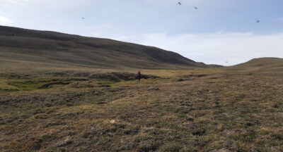
The Muskox Valley exhibits a spectacular and serene sight despite the millions of mosquitoes. The low U-shape of the valley becomes very prominently visible. There were green pastures at the bottom of the valley—a living room of a muskox that we encountered that day. Lidar mapping was carried out meticulously following the troughs and other terrain features to capture the valley topography.
We got the camp in our sight sunbathing by the river of melt water from the glaciers just after 5 pm. The plane circled around the camp set on a river plain and landed with a slight jump on the flat river bank approaching from the east. We rolled closer stopping right next to the space dome, which was our living room for the next couple of weeks. We unloaded the gear, the plane accelerated across the makeshift airfield, took off and we were alone in the middle of nowhere. What a feeling of freedom!
The next big issue was to sort out the water supply. The river was all mud that clogged the water filter we had so we had to improvise for a pre-filtering with a bucket and piece of cloth dug close to the shore to let water seep in with much less sediment. That worked reasonably well for the stay, as the first day’s search for ice or clear water supply close enough to the camp was not successful. The sleeping tents were pitched a good ways away from the toilet and the mess tent with kitchen and food, and surrounded with a banger fence for the not-so-wanted event of a polar bear visit. Luckily we did not see any this season.
The everyday camp activities include making food and doing dishes and tidying up the mess tent. Morning routine was to take scheduled radio communication checks with PCSP. Satellite phones were available and useful when the team was split in various, often very distant field sites to check all ok, and inform travel routes and rendezvous, especially critical coordinating on days when we had helicopter transport. Electricity was provided by a small 2 kW generator to charge computers, GPS devices and science equipment batteries.
After a busy day in the field there was always a need for backing up and processing data and writing and completing field notes. And of course dining, discussing the environment and finds and experiences of the day, coming days’ fieldwork, science and publications, literature, movies and what not. As the Sun was up all night long, it was often quite long days before the camp got quiet and the team went off powering themselves up for the next day.
Trip to Muskox Valley
On our sixth day to the expedition I got to team up with Mark and Shawn for a trip to a then unnamed glacial valley recognized from satellite imagery to be interesting for the purpose of studying subglacial channel morphology and hydrology. The plan was for the helicopter to drop us off somewhere down in the valley for the day and return to the camp to deliver the other members someplace else. So we packed food and water, batteries and equipment, bear bangers and a shotgun into the back of the helicopter and jumped in. The site was located about 60 km North of the camp, so the flight was only about half an hour, but looking down the window for the terrain we saved a lot of sweat and effort crossing multiple rivers and rugged terrain, should we have to get there on the ground by ATVs, that’s for sure!
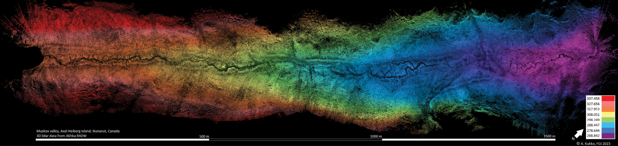
Elevation model of the Muskox valley based on the expedition lidar data. The glacial lake is located to the left of the image, and the glacier front is further to the South-West beyond the left of the image. Valley continues to the North-East to join a river further down the road. Muskox was met just at the edge of the image to the right.
We had a brief fly around above the valley for photography and reconnaissance of the site before landing, and the pilot took us down to a selected spot of which was to become the lower end of the scanning work with the backpack lidar. The topmost point would eventually be about a 2 km distance up the valley by a small glacial lake. The site occurs within a recently deglaciated valley on the eastern side of the island, and lies a few kilometers to the southeast of a prominent ice lobe extending from the Müller Ice Cap (79° 54 ‘44.4”N 89° 10’ 37.1”W). The full valley is 8 km long and 1 km wide, and has a flattened U-shape, typical for a formation of subglacial origin. Eastern Axel Heiberg region has a polar desert climate with an annual mean air temperature of -19°C. During our expedition though, we experienced 15-20°C day temperatures, compared to the July average of 6°C for the past 40 years.
When on the ground we could feel the fresh breeze with a smell of the glacier a few kilometers to the west in the air. The valley was covered with tundra vegetation, small white flowers blooming all over, low grass looking burnt dry higher on the valley slopes, but lush at the bottom and in the polygon troughs where traces of streaming water and small bonds could be found. And as a result of standing water we were soon to find that there were a few others as well.
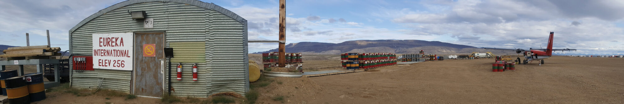
Eureka International Airfield offers all the basics a frequent flyer needs.
That thing soon became apparent when we hopped off the helicopter. There were millions of mosquitoes in the valley that became voraciously swarming on us! Luckily me and Mark had our mosquito hats, Shawn was not that prepared, unfortunately, but could use his hood and scarf to allow breathing without a mouth full of insects. There is a specific word in the Finnish language, räkkä, to describe the mass occurrence of biting insects, like mosquitoes and blackflies, during the summers in Lapland.
We left some of our backpacks and other stuff with food and other items in a pile on the landing site, waved the helicopter off, and set us up for the scanning and site survey. Mark volunteered for the first tryout of the backpack scanning, so I gave him an introduction on how to paint the scene with my lidar brush, and soon he started snaking up the valley from side to side and contouring the trough formations to capture the terrain topography of the valley like a pro! Shawn started photographing and making a survey of the valley sediments, hydrology and landforms. I took the bear watch and explored the terrain, especially intriguing was the landslide lobe protruding in the valley from the southern slope.
Meet and greet with a muskox—a Mexican standoff
After the first set of batteries that was spent in about ninety minutes, I took over the scanning duty and Mark went off to Shawn down the valley to explore. After a short while I heard a bear banger to go off, and probably Shawn shouting. I looked down, and saw them standing near a small crest on the southern slope where the valley narrowed and turned slightly to the right from my vantage point and out of my sight. Both men were standing still looking further down the valley, but I could not see much because of the distance and obstructing terrain. As I spotted nothing too serious to be going on and having Mark and Shawn as bites between me and the unknown to me visitor, I continued the scanning.
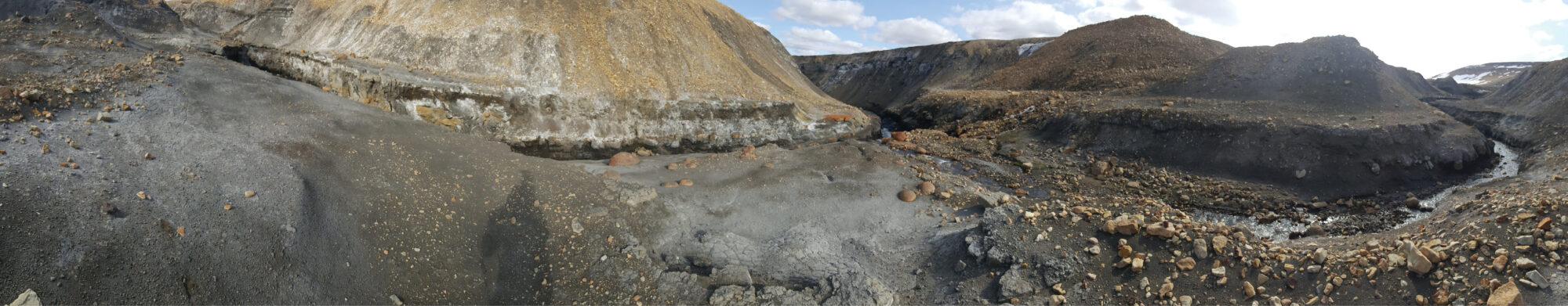
Concretions all over the place. Meltwater erodes sharp channels through the landscape. I came to this location down from the glacier along the channel to the right.
In a short while a couple of additional bangs went off, but not much else seemed to happen down the valley, so I considered Mark and Shawn to be on top of the situation. And in a while Mark and Shawn started to hike up the valley behind me, so everything seemed to be calm and fine. When the duo eventually came up to me they told me Shawn had had a close encounter with a muskox grazing just behind that small crest at the valley bend a short distance from our landing. Despite the giant size the hair and color of the animal provide a good visual cover in the environment we were in, and Shawn had been notified for walking too close, within a couple of meters, with a loud snort just behind the corner. Being the owner of the house the muskox had come closer with apparent interest on who we were despite the bangers, but fortunately eventually stayed back after a standoff.
We decided to take a bit more distance to the beast and headed from the location up to the lake, and finally reached the shore of a small oblong glacial lake and set the instrument down for a break. We enjoyed the scenery with some snacks by the lake for a while having an occasional eye on the muskox, if it was to follow, but it kept the distance and stayed the rest of the day grazing so close to our gear cache that we could not reach them until the arrival of the helicopter scared it off late in the afternoon.
From the lake shore Shawn took the lidar backpack and started to scan the very prominent troughs at this location following the channel back down the valley. Me and Mark pondered the marks of a lake outburst and obvious relatively recent lowering of the lake surface. I got to complete the scanning of the middle portion and the upper slopes of the area in the valley, as we had passed it on our rush way up to the lake.
Despite the excitement, as a result of the scanning we could reconstruct the topography of the site now dubbed as Muskox Valley! Back home the lidar data collected was turned into a very high-resolution digital topographic terrain model with 2 centimeter resolution (shown below) to permit computational analysis of the properties to characterize the valley morphology, channelization and hydrodynamics, and for assessing erosion and sediment transport in an event of a glacial lake outburst. Based on this model and field study we could perform scientific analysis and simulations, and findings will be published in Nature Communications in the near future (Chartrand et al., accepted for publication).
The current expression of surface channels along Muskox Valley is diverse, depending on the presence or absence of polygons. High-resolution lidar model shows that the character and extent of erosional channel incision is spatially discontinuous along the valley. Whereas well-developed channels are common around the edges of large polygons and within inter-connected troughs, channelization is diffuse or non-existent where relatively poorly developed polygons occur in wetlands. Polygon geometry seems to be able to influence, even govern the channel path both across and down topographic gradients at the valley.
Wrapping up the expedition
During the two weeks I could perform scans for the expedition goals at multiple locations near the camp, up on the plateaus west of camp and even at a couple of locations in the vicinity of Strand Fjord on the west side of the island. Some of them were quite extensive, like subglacial valleys and a thaw slump that took multiple hours of mapping, some more localized patterned ground features. For Chimira’s study we scanned a large section of polygon formation on the southern slope of the Strand Fjord at its east end. The most peculiar place I got to visit was the so-called brain terrain formation about 30 km north-east of camp I scanned for Shannon for her PhD study. Brain terrain is an extraterrestrial feature seen expensively on the surface of Mars, but the location seems to have an analog here on Earth. Chimira and Shannon were also carrying out ground penetrating radar surveys to reveal ice wedges and other structures beneath. I was also able to map a narrow glacial melt water channel eroded through the permafrost ground and ice for Anna. The channel opened up to a larger stream and rapidly rushing waters, where erosion had exposed a lot of concretions of various sizes, the largest I saw was about 1 meter in diameter.
Time for farewell in good spirits. Thanks for an extraordinary team spirit and expedition Mark, Shannon, Shawn, Anna, Oz, Chimira and Etienne! This Twin Otter took Mark and Oz back to civilization, we were to follow three days later.
As it usually goes with expeditions with lots of new things to explore, the time went by quickly. We had fairly good weather and warm nights throughout the stay. On 12th of July the first Twin Otter arrived to take Oz and Mark back to civilization.
After the departure of the first plane out we got to spend a couple of days with the smaller group to do some more field work and data backups, finalizing fieldnotes, data processing and what not, backing up the camp and chilling out with good camp food, music and company. On the day out we lowered all the tents except the big space tent to allow quick loading of the plane. When the plane finally arrived in the mid-afternoon 15th July, we stuffed the gear, samples and ourselves into the plane and off we went.
Eureka International Airfield is the northernmost location I have visited thus far, and we visited there to refuel the airplane on our way out from Axel. We got a drive to the outpost canteen a stone’s throw away from the airfield with an old green NRC van, once decommissioned but reclaimed by the mechanics of the outpost. A cup of hot coffee and fresh chocolate biscuits close the circle for this expedition. Until next time!
Antero Kukko is a research professor at the Finnish Geospatial Research Institute and leads the Autonomous Mapping and Driving research group of 40 personnel. His research interests include integrated mobile, UAV and airborne laser scanning systems, positioning, autonomous systems, and applications and computational methods using multi- and hyperspectral lidar for geospatial research, mapping, forestry and geomorphology.