This next generation of LiDAR elevates our mid-range sensor, offering enhanced density, improved accuracy, and precision, producing a superior point cloud.
Geo Week 2024, Denver, CO. – GeoCue, a leading geospatial hardware and software provider, and CHC Navigation, a pioneer in precision positioning solutions, proudly announce the launch of the TrueView 540. This innovative collaboration brings forth a new efficient and flexible survey-grade LiDAR system to North America, introducing an unparalleled combination of the LiDAR payload with LP360 3D Point Cloud Processing Software.
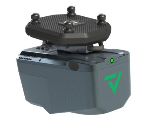
The all-new TrueView 540 is a new generation of intelligent aerial surveying system from CHCNAV powered with LP360 processing software.
TrueView 540 is a next-generation intelligent aerial surveying system developed by CHC Navigation, available through GeoCue. This next generation of intelligent aerial surveying is the result of six years of innovation and three years of meticulous product development, harnessing the power of CHCNAV’s state-of-the-art LiDAR technology.
The TrueView 540 integrates survey-grade high-precision LiDAR, an accurate positioning and orientation system, and a full-frame industrial camera. This unique combination enables fast and accurate acquisition of 3D data in a compact and lightweight LiDAR system that can be easily installed on various drones like the popular DJI Matrice 350 or any 3rd party compatible UAVs.
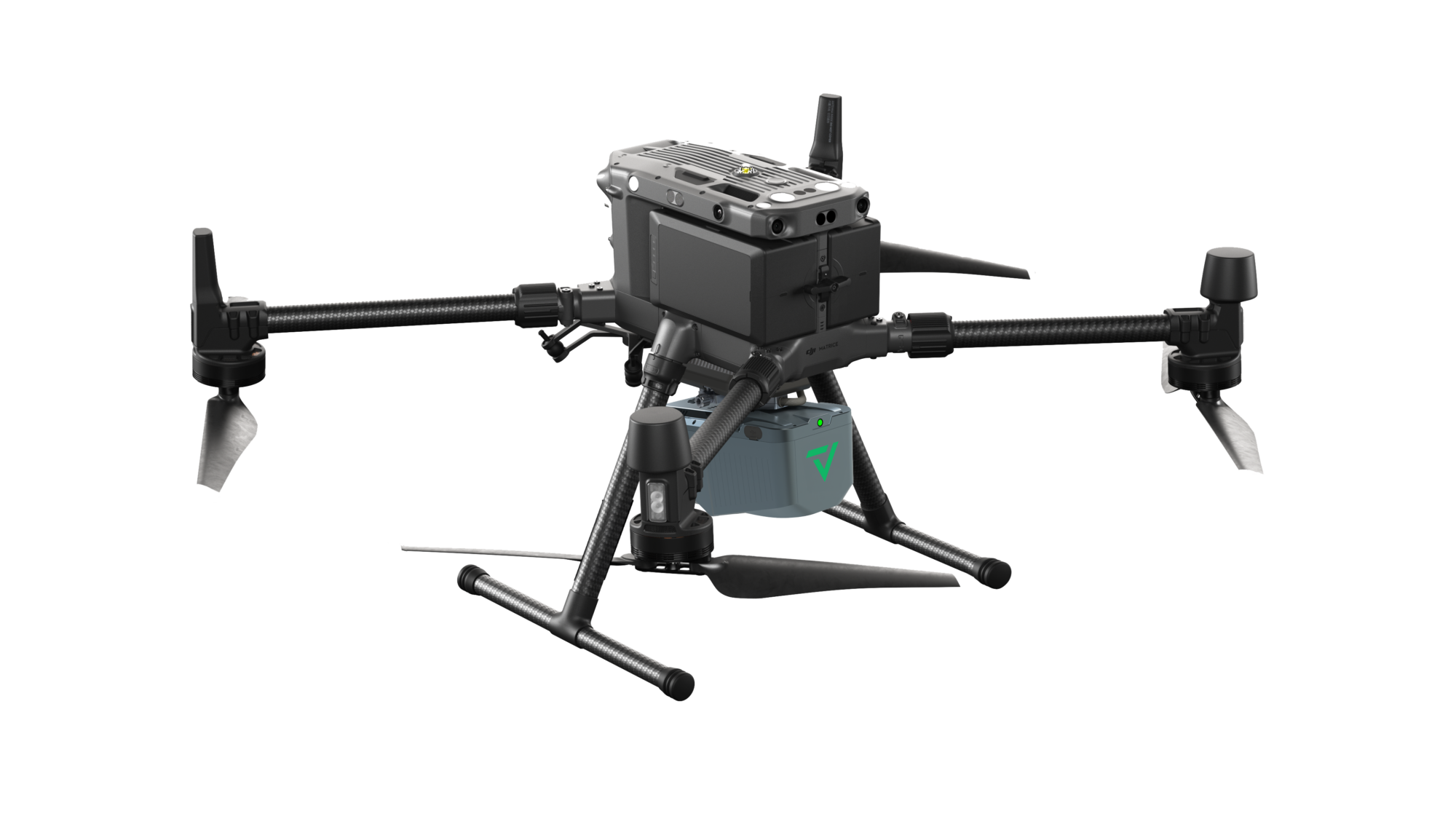
The new TrueView 540 is a compact and lightweight LiDAR system that can be easily installed on platforms like the popular DJI Matrice 350.
“GeoCue is excited to bring the TrueView 540 to the market,” explains Frank Darmayan, CEO of GeoCue. “This collaboration with CHC Navigation represents a significant advancement in aerial surveying technology, providing professionals with a unique combination of a best-in-class LIDAR sensor with the best-in-class processing software,” says Darmayan.“
George Zhao, founder, and CEO of CHC Navigation, also looks forward to the new collaboration. “I am proud to join forces with GeoCue to introduce the TrueView 540 to the market,” he said. “Our collaboration is built on shared principles and ideologies, such as integrity, excellence, and a commitment to the vision of creating an intelligent world through precise geospatial information. GeoCue mirrors our dedication to delivering competitive, high-value-added technologies and services to our customers. Together, we embark on a journey to redefine geospatial solutions and set new standards in the industry.”
Key Features of TrueView 540:
- Survey-Grade LiDAR: The system features high-precision LiDAR technology, comparable to the range, density, and accuracy of high-end industry-standard payloads.
- Availability: TrueView 540 is available through GeoCue and authorized GeoCue distributors, providing a unique product in the market.
- Efficient Data Processing: All processing for TrueView 540 is done using GeoCue’s LP360 Drone, ensuring streamlined and efficient data processing.
- Attractive Pricing: GeoCue and CHCNAV bring a high-performance yet competitively priced alternative to the UAV LiDAR market.
Vivien Heriard-Dubreuil, CEO of GeoCue parent company mdGroup explained, “With the launch of TrueView 540, we now present a distinctive and compelling choice, blending exceptional performance with an appealing price point, available exclusively from GeoCue and our trusted distribution partners. Our new product provides geospatial professionals with a game-changing, high-end payload at an accessible price, enhancing end-user efficiency and maximizing their return on investment.”
TrueView 540 is set to elevate the standards of aerial surveying, offering professionals a groundbreaking solution for their survey-grade LiDAR needs. The product will be launched at Geo Week 2024 and available beginning in March 2024.
About CHC Navigation
Founded in 2003, CHC Navigation creates innovative mapping, navigation and positioning solutions to make customers’ work more efficient. CHCNAV products and solutions cover multiple industries such as geospatial, construction, agriculture, and marine. With a presence across the globe, distributors in more than 120 countries, and more than 1,700 employees, CHC Navigation is today recognized as one of the fastest-growing companies in geomatics technologies. To learn more about CHC Navigation, visit www.chcnav.com
About GeoCue
GeoCue brings geospatial experts the very best in drone surveying equipment, geospatial software, workflow, training, and support for high-accuracy LiDAR and drone mapping to help civil engineering and surveying professionals achieve successful data collection, processing, and management. With TrueView drone LiDAR/Imaging sensors and LP360 point cloud data processing software, we are the leader in LiDAR mapping processing in North America able to meet customers where they are in terms of technology adoption, budget, and resources. To learn more about GeoCue, visit www.geocue.com.
