The anomaly of having two nearly identical units of linear measurement has led the USA to discontinue the use of the “US Survey Foot” after 1/1/2023. This then leaves the “International” foot as the only standard unit of linear measurement in the USA. However, the USA also has two nearly identical ways of stating dimensions in land surveys. Either grid distances on their SPCS coordinate projection plane [usually at Sea Level] or horizontal ground distance [where measured and used] are stated as dimensions. The continuation of this anomaly and duplexity prompts this Paper.
Back in the 1970’s, in New South Wales, Australia, the reverse situation arose. Then, the surveying profession proposed survey coordination, similar to the USA State Plane Coordination System [SPCS], that required Projection [grid] distance [instead of the established horizontal ground distance that everyone was using] as dimensions on survey and title plans. Also, so that the proposed grid distance dimension approximated horizontal ground distance, they required a 20 zone UTM projection [in addition to the established 60 UTM mapping projection]. This Paper recounts the rationale used to ultimately reject the grid distance and 20 zone proposal.
Compared to the USA, Australia is “down under”, 10o to 45o south of the Equator [USA is 25o to 50o north]. It is slightly smaller in width [4,000 Km to 4,500 Km] and in area [7.7 M Km2 to 8 M Km2]. Average elevation is about half [330 m to 760 m]. Settlement commenced later [1788 compared to 1620 “Mayflower”]. So, both are similar in many respects, including the British colonial land boundary practices. Upon the colonisation of New South Wales in 1788, all land was “taken” as Crown land [Public domain] and was leased or granted for settlement by metes-and-bounds, visible marking and written description. Surveyors used circumferentors and compasses with reference to magnetic north for bearings and used a Gunther’s chain for measurement of boundaries. Later [1872] after the use of theodolites became mandatory, and when a long, thin, steel chain came into use, there was a significant improvement in the precision of surveys. Chains required regular standardisation to ensure accuracy. For nearly 100 years [in the 1970’s] this NSW [and Australian] survey and [Torrens] land title system underpinned property values and had proven itself to be precise, reliable and trusted.
The NSW Survey Integration proposal [similar to SPCS in the USA] was timely. It was claimed to be “the first comprehensive system of surveys in the state”. It sought to replace [1] magnetic north, true north, and azimuth from abuttals, with grid north and [2] to integrate ad-hoc surveys with control surveys and a coordinated cadastre [both were adopted]. However, it also proposed coordination copied from SPCS and similar ‘narrow zone’ coordinate systems from overseas. In this, [3] all stated land, survey and title dimensions were to be Projection [or grid] distances on a coordinate projection plane [at sea level] and not where measured and used. This then required [4] a 20 Integrated Survey Grid [ISG] so that the grid distance dimensions would be “near enough” to measurement and ground distance.
The NSW proposal had support of the Surveyor General, academic surveyors, surveying professional bodies and the heads of most government Departments. This, and its use overseas, gave it credibility. Further, any argument against the matter under dispute was seen as opposition to the proposal as a whole, and was disregarded by its NSW proponents. Ultimately grid distance and its 20 zone were opposed, and then rejected, by the Registrar General of Titles [and others] in 1975.
In mapping, all distances on the projection plane are grid (or projection) distances, being in standard linear units on that plane. Distance, where measured and used, are ground distances in standard linear units at ground level. Consequently, grid distance dimensions (in SPCS or ‘narrow zone’ coordination) vary from place to place and height to height with the horizontal distance of that measured at ground level by (1) a scale (projection) factor and (2) a height (above sea level) factor. These are combined as (3) the ‘grid-to-ground’ conversion factor between grid and ground distances (Figure 1).
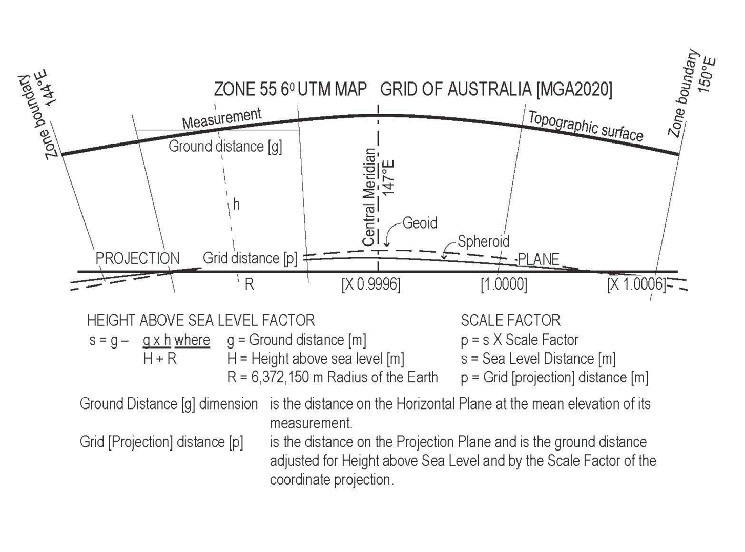
Figure 1: Ground distance to grid distance adjustment.
A dimension is the written statement of a measurement. Ground distance, with its direct nexus with measurement, is universally stated as the dimension in land measurement. [Grid distance stated as a dimension, calculated, not measured, is the only exception to this precept.] In this context, because grid distance varies from place to place and height to height with measurement and, like coordinates on the projection plane, it cannot be measured, it does not perform the function of a dimension in land surveys. Also, as it is not stated in coordinate mode, it does not perform the function of position reference in a coordinated cadastre. It has no function. To be of any use, it must be multiplied by the “grid to ground” conversion for a dimension or by trigonometrical functions for position reference. It is really a transitory, non-essential component in coordinate calculation.
In surveys, precision and accuracy of measurement is important and expected of a surveyor and the public generally. The surveyor makes adjustment (not corrections, unless there is an error) to replicate the exactness of the standard linear units of their measurement. All measurements are adjusted to the horizontal or level at its mean height. This is the shortest distance between two points and is known as ‘ground distance’. It is defined as “the distance on the horizontal plane at the mean elevation of its measurement”. It was because of this established precision and accuracy in Australia that the proposal to state often-approximate grid distance dimensions was considered a specious practice, and was opposed…
As a general rule, mathematical consistency [when units of calculation must be the same uniform standard measure] is required in calculation and to be shown on plans. Consequently, for mathematically consistency with their coordinates, the NSW Survey Integration proposal prescribed that grid distances dimensions should be shown on plans, even though they were measurably different with ground distance. However, coordinates and dimensions have different modes of statement. Their different modes of statement then allows precise ground distance dimensions and projection coordinates, with their own different standard linear units, to be clearly shown on the same survey plan without confusion. In Australia, by Regulation, a “ground-grid” distance Conversion Factor, MGA zone and datum, and often a schedule of coordinates, are also stated on plans (Figure 2)
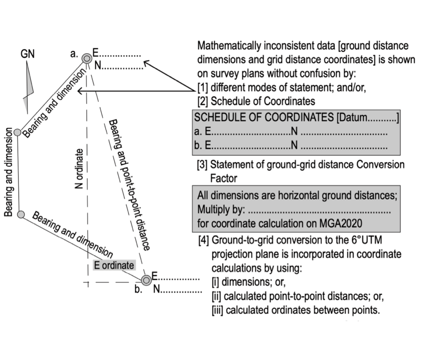
Figure 2: Statement of mathematically inconsistent data on survey plans without confusion.
A paradox of the NSW Survey Integration proposal was the conversion of precise measurement and ground distances to the often-approximate grid distance dimensions, and then convert back from the grid distance dimensions when precise ground distance dimensions were later required. This was required whether coordinates were used or not, and was subsequently rejected. Instead, in Australia, with ground distance dimensions, the ‘ground to grid” conversion is made only once, being with the obligatory coordinate calculation. Also, as this is a calculating quantity only, [and, unlike the NSW proposal] the zone width does not have to be minimized for grid distance dimensions to approximate ground distance. Consequently, any projection zone width can be used. In Australia, the existing mapping 60 UTM zone was adopted instead of the proposed 20 ISG.
Horizontal ground distance is in standard linear units where measured and used. Unlike grid distance dimensions, standard units do not vary with location, elevation or coordinate system.
Usage supports ground distance. Practically all development is built on the level of its measurement where it can be readily measured and used without: [i] the imprecision of often-approximate grid distance dimensions; [ii] the need for “grid to ground” conversion; [iii] without coordination; and, [iv] without need for a “narrow zone” coordinate projection.
Also, horizontal ground distance is mathematically consistent with existing and other dimensions and inter-related systems of area, volume, etc. This is important in design where construction elements are prefabricated off-site. [apparently this has been an issue with grid distance dimensions]
Comparatively significant, horizontal ground distance is acknowledged by the need to minimise the “grid to ground” difference of grid distance in SPCS, “Low Distortion” Projection Coordination, the 20 ISG proposal, and other “narrow zone” projections. This is so grid distance approximates ground distance.
In Australia, in 1970, the basis of establishment already existed. Horizontal ground distance dimensions and the 60 Australian Map Grid [AMG], based on the then existing 1:1,000,000 scale International Map of the World [IMW] series and topographic maps were used. This obviated the need for SPCS, the 20 ISG proposal or any other coordinate system (Figure 3).
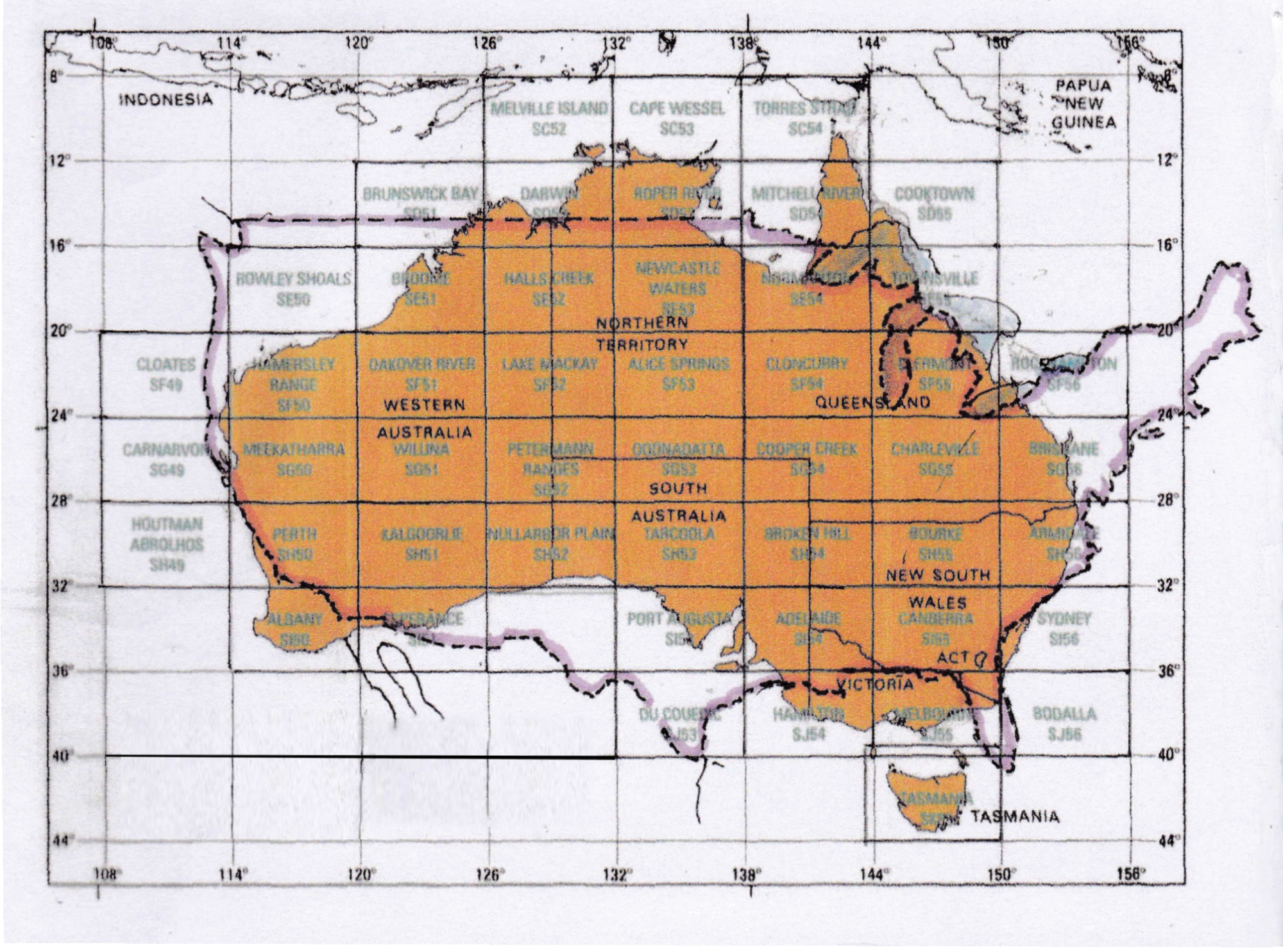
Figure 3: Map of Australia 6˚ UTM Mapping & Coordinated Cadastre (USA outlined at same scale).
Its logical to have one coordinated cadastre for all spatial position reference purposes. The use of the 60 UTM coordinate system for surveying and mapping provided one homogenous national datum and one common spatial data system. Also, the much larger 60 by 40 UTM zone [600km by 450km] with 1/2 0 [100km] overlaps avoided the discontinuity and confusion of additional smaller coordinate systems such as occurred in the 20 years when the 20 ISG also applied in NSW mapping. It also made the changes [AMG, MGA94, MGA2020] due to movement of the Australian Tectonic Plate [7cm NNE each year] comparatively easier.
Project-specific coordination can still apply, as appropriate. The 60 UTM coordinate system can provide overall control to be transposed to ground level, and, with ground distance, be used for “low distortion” coordination, project coordination, centreline and cross section, datum lines, set out for prefabricated structures, etc.
In Australia, all land dimensions are only horizontal ground distances and all surveying, mapping and spatial data coordinates are only on the 60 UTM projection. Rationally, with grid distance dimensions rejected as an anomaly, the Australian practice provided:
- a complete and unambiguous dimension and coordination system for all uses.
- no duplexity and less confusion with just one dimension and one coordinate system.
- obvious benefit / cost savings of having the one system.
The Australian practice has proven itself over the last 50 years. During this time computers and software have made calculation easier and almost automatic. Measuring equipment [EDM] and new techniques [GPS, GNSS, CORS, etc.] have improved the precision of measurement. Having only horizontal ground distance dimensions and only 60 zone coordination has made this implementation so much easier…
Prompted by deprecation of the “US Survey Foot”, it is recommended that: the anomaly of also having either grid or ground distance dimensions on plans in the USA can be rectified by [1] deprecating all grid distance dimensions, and, [2] stating only horizontal ground distance dimensions in all land surveys.
[This Paper has been adapted and abridged from a larger Paper written for a NSW, Australia, surveyor readership and published in the proceedings of the APAS2022 Conference, available at www.apas.org.au and a subsequent Paper published in the “Coordinates” magazine December 2022]
John Read is a Fellow of the Institution of Surveyors NSW and Emeritus Surveyor. John became registered as a Surveyor (1965) and qualified as a Town Planner (1972), Real Estate Valuer (1979) and in Public Administration (1983). He was involved in the 1970’s NSW Australian Grid vs. Ground distance deliberations.