The final stages of building the Modernized National Spatial Reference System (NSRS) have now come into focus. NGS is now in the process of compiling, organizing, and cleaning all of the relevant GNSS and leveling data contained within the NGS Integrated Database and the OPUS shared solutions database. The cleaned data will be used in a series of national scale survey adjustments using our brand new custom software package called LASER (Least-squares Adjustments: Statistics, Estimates, and Residuals), to compute the initial sets of geometric and orthometric reference epoch coordinates (RECs) on hundreds of thousands of existing survey control marks and CORSs around the country. NGS will then use those new coordinates to produce the suite of models and tools that will enable users to access and work within the Modernized NSRS.
For the past several years, NGS’ GPS on Bench Marks program has been encouraging stakeholders and partners around the country to submit GNSS data to NGS on marks that they use, to ensure that they have updated RECs when the new system comes out, and to improve the local accuracy of the NAVD88-to-NAPGD 2022 transformation tool. While NGS will continue to accept submissions of user data into the future, on February 29, 2024 we will be closing the doors for GNSS and leveling data to be considered for the initial REC national adjustments and for use in building the transformation tools.
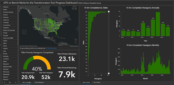
The GPSonBM Transformation Tool web map shows where NGS has GNSS data on published NAVD88 marks and where there are still gaps. The GPSonBM Progress Dashboard illustrates the progress that each state and territory has made toward NGS’ goal of 10 km data spacing nation-wide. These online tools will continue to be updated regularly through the end of the Transformation Tool campaign, and may be changed in the future to support new data collection requirements, such as survey epoch coordinates in areas of motion, and future reference epoch coordinates. Because NGS will build national-scale transformation tools with the data we have, we must interpolate over data gaps which reduces the local accuracy of the transformation tools in those areas. Users are encouraged to explore the tools linked above to investigate the data coverage in their areas, and to collect and submit GNSS data to NGS to fill remaining data gaps. For questions or technical support contact us at ngs.gpsonbm@noaa.gov or reach out to your NGS Regional Geodetic Advisor.
