December 7, 2023 – Montreux, Switzerland – TOPODRONE, a Swiss based designer and manufacturer of high-precision surveying equipment, recently completed its R&D and released a new drone thermal mapping solution. TOPODRONE PT61 camera can perform detailed surveys and deliver thermal orthomosaic maps obtaining accurate 3D models.
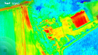
Thermal data captured with TOPODRONE PT61 camera © TOPODRONE
The new photogrammetry solution was initially developed in collaboration with AGROWING upon a request of a large enterprise client from North America and later on has been adjusted to a wider use of drone surveyors. It is a camera with 61 MP resolution and built-in thermal imager, and RGB lenses with different focal lengths, built-in GNSS module and IMU, as well as API for integration with any UAV. The combination of the PT61 camera with AGROWING’s multispectral lenses enables TOPODRONE to provide the camera as a dual-purpose RGB/Multispectral solution. Using the PT61 camera with AGROWING’s Quad lens, the camera provides 10 multispectral bands of 12 MP resolution each along with the IR band.
“This year we observe an increased demand from surveyors for solutions related to renewable energy. Combining thermal and LiDAR data can definitely provide deeper insights, in particular, in solar plant inspections and dam management”, Iliya Shikov, TOPODRONE CTO, explains.
‘AGROWING has been partnering with TOPODRONE for a few years together providing cutting edge photogrammetry technologies. We welcome TOPODRONE’s new thermal mapping solution, moving a significant step forward in the race to provide valuable data-driven insights into urban mapping, energy efficiency and disaster response’, Ira Dvir, AGROWING CEO, adds.
TOPODRONE Post Processing software has been upgraded to optimize remote sensing efficiencies and deliver high-precision thermal orthomosaic maps.
To learn more about the solution join a free webinar on December 13, 2023 – register at https://us06web.zoom.us/webinar/register/WN_Ud1NRAZYR4q02t9eIPMcbQ.
Earlier this year TOPODRONE released TOPODRONE SLAM 100 for mobile mapping and a new lightweight 360° LiDAR model range: TOPODRONE LiDAR 200+, 100 & 100+. All of them as well as photogrammetry solutions and TOPODRONE AQUAMAPPER for drone bathymetry were showcased at INTERGEO 2023 in Berlin.
About TOPODRONE
TOPODRONE is a Swiss based designer and manufacturer of high-precision surveying equipment for installation on UAVs, vehicles and backpacks. TOPODRONE’s hardware (LiDARs, high resolution cameras and PPK) are used for mapping and 3D modeling. Application areas include but are not limited to forest and agricultural monitoring, construction and urban planning, and bathymetry. TOPODRONE’s advanced post-processing software provides users with easy-to-use innovative data processing workflows for automatic data generation, georeferencing and alignment using GNSS and IMU data post processing, and SLAM algorithms. For more information, visit topodrone.com
About AGROWING
Founded in 2014 AGROWING’s vision is to provide the required technologies for real-time Leaf-Level AI trustworthy detection and identification of pests and diseases of agriculture crops. AGROWING provides worldwide patented multispectral sensors of high resolution and 10 and 14 spectral bands. AGROWING’s award-winning affordable solutions are based on modified top of the market mirrorless digital cameras combined with its unique lenses. AGROWING’s patented Imagery Acquisition Method of remote and close sensing secures effective early identification and AI-Classification of pests and diseases. AGROWING’s sensors design enables acquiring imagery of 1.7cm per pixel from 100m altitude and also from as close as 3m above the crop with Leaf-Level AI-enabling resolution of sub 0.5mm per pixel. For more information, visit https://agrowing.com
