With the advent of easy, convenient, and available GPS coverage around 1999, lidar has become the standard for delivering timely and accurate 3D data for mapping applications. Its native form is to deliver with an intensity attribute, but RGB color can contribute to a better understanding of the environment.
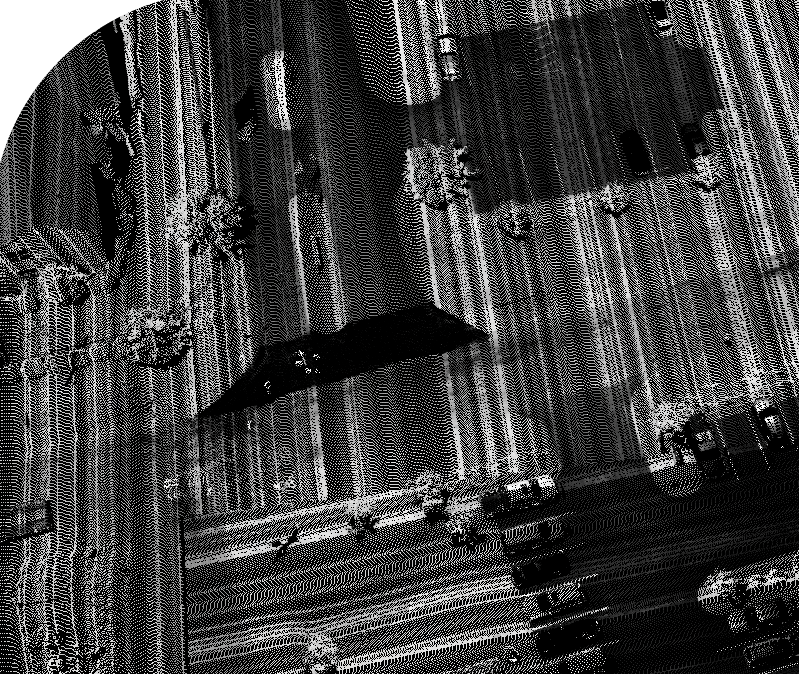
Figure 1: Intensity image. Where is the sidewalk, parking lot drainage and grass areas?
Lidar systems were just emerging into mainstream mapping in the late 1990’s. Systems had been around earlier on both automobiles and airplanes, but they were severely limited by hardware and GPS availability. They were also quite large and expensive. By the mid 2010’s things had changed dramatically. In 2016, with the release of the DJI M600 (heavy lift multicopter) and the Part 107 regulation (in the US), UAV-borne lidar systems became a reality. Prices dropped to something much more within reach of smaller mapping companies and the brave entrepreneurs who lead the way by taking risks.
During this same time, disk storage became cheaper, faster, and smaller and computers continued to do the same. Fortunately, the lidar software also experienced very significant and much needed improvement in handling large data sets with billions of points possible in even a simple project. Equally as important, more GNSS constellations became available, more satellites, more frequencies and again, some very important improvements in positioning systems and software.
Industry Growth
As the aerial lidar market experienced incredible growth over the past two decades, mobile lidar lagged behind by at least a decade. Now, however, lidar on all platforms is at the forefront of a booming industry. The hardware has miniaturized and the software has matured and they continue to do so. Pricing for an MMS (car mounted lidar system) has dropped from over $1M to under $100k.
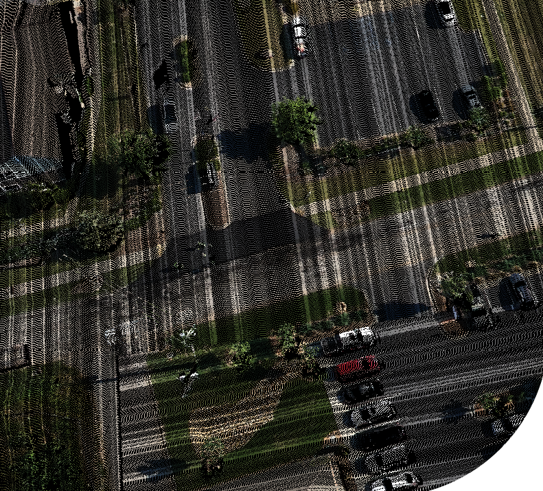
Figure 2: Fully colorized point cloud. Sidewalks clearly visible along with drainage from parking lot.
Even more though is the dominance of UAV lidar. Prior to 2016 all efforts to move the UAV lidar industry ahead were blocked by one thing or another. But since then, things have really changed. We now have everything a smaller form (INS, lidar sensor, and computer). These all nicely fell into place at just the right time.
What drives the need for lidar is its ability to capture 3D data through direct measurement. In the case of aerial lidar, this means directly measuring the tops of vegetation and enough of the ground (by slipping through and between the leaves and grass) to get a true ground model (DTM or digital terrain model). This is its primary advantage over a passive imaging system (photogrammetry). Because of the nature of direct measurement, it is also very good at measuring power lines and railroad tracks (small, sharp linear features). Needless to say, direct measurement independent of ambient light allows for around the clock capture which is also very helpful when working within a tight schedule. In any case, an engineer needs reliable 3D information to do their design and lidar provides this.
Intensity is Good
It is true that the intensity associated with every lidar point (captured during direct measurement as the strength of the laser return) is very beneficial. It gives the sense of a black and white photograph if there are enough points. However, if it can be enhanced with RGB values to provide color, that increases the value of the data a great deal in some applications. The only way to get color is to add a passive collection system—a camera. This obviously limits our collection to daylight hours (which is normally when you are working anyhow).
Costs of Colorizing.
Colorizing remains no substitute for an image, but it certainly enhances the viewer’s ability to discern objects in the environment. There is often a problem though when it comes to capturing imagery to colorize the lidar. It is most convenient to do this in a single flight with both sensors. This can be difficult because the mission planning for the two sensors may conflict, requiring different sidelap and flying heights. A good design will maximize flight time, minimize cost, and avoid lengthy processing. Likewise, it should enable colorizing not only of rooftops but walls and other vertical features as well. Again, this can be a bonus on any project (unless the deliverable is truly a DTM only).
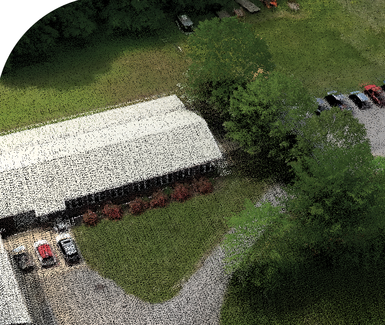
Figure 3: LIDARUSA Office. Notice white trim on windows under under 2ft eves! Rose bushes in blossom. Very photo realistic.
Using a lightweight camera system, properly timestamped and boresighted, with a sufficient FOV (at least 120 degrees), all of the design considerations can be achieved. The point cloud is processed normally as if no camera was present and then additionally every lidar point is tagged with an appropriate RGB value from the imagery simultaneously captured. In doing this, there is very little displacement from temporal changes (as happens from separate flights for each sensor) and relief displacement resulting in a beautifully colorized point cloud at little expense.
Emerging Systems
Since early 2022, LIDARUSA has provided UAV colorization as an option using a GoProMax 360 camera. This allows users to meet their clients demands for a colorized point cloud without breaking the bank.
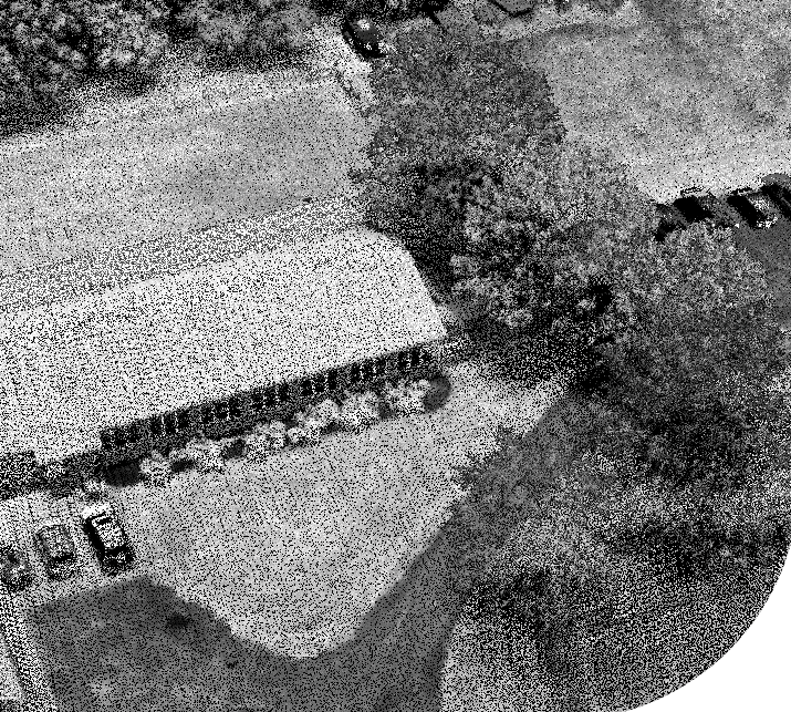
Figure 4: Same scene without color. Still useful but hard to identify vehicles and can’t tell the season.
There is more though. Lidar vendors are now working on the capability to capture color while scanning. This reportedly will be available in 2024. All users will immediately have color capability from any collection platform. No secondary camera necessary. No colorization issues from poor boresights or calibration. Direct colorization with RGB just as with intensity.
It’s here today
If you are in the business to grow your business as a surveyor or mapper, then UAV (and car and backpack) lidar is definitely one of the best ways to make that happen. Your clients no longer have to be satisfied with a 2D map. They can be provided with an on-line 3D colorized presentation with simple mensuration tools that allow them to do much more than they can from a 2D drawing. It is impossible to imagine all the doors that such capability can open for you and your clients. All of this technology is available today.
Jeff Fagerman is the founder of LIDARUSA providing lidar and photogrammetry systems worldwide from a family run business since 1999.