Introduction by Chuck Ghilani
After 25 years, I retired from the Penn State Surveying Engineering program. Recently I had an email conversation with one of our first baccalaureate graduates. Since graduation, he had obtained his professional license, became president of the PSLS, was given the Surveyor of the Year award from the PSLS, and took over his father’s surveying business. Previously, he told me how he used GIS and freely available GIS data as his first approach to a perspective job. In our recent discussion, he mentioned how he used a sUAS system with a camera and LiDAR system to do most of his topographic work. This minimized his company’s field time and crews. In fact, he suggested that in the future he thought that only boundary surveys would require extensive fieldwork. (AC – Pipersville, PA)
At the time of my retirement, the Penn State Surveying Engineering program was one of eight such programs in the country. You might think that Pennsylvania surveyors would back such a program, which most did over the past 25 years. However, there was a small sector of the society that did not understand what a BS degree in surveying provides a graduate. One of the statements often heard from this sector was, “I can teach them everything they need know on the job to become a surveyor.” My response would be, “Really? With all the new technology, I couldn’t even do that!” I am not going to get into the psychology behind their statement, but I realized that I could ask the many graduates for which I had contact information, to see what they are doing now. This paper presents a summary and sample of the responses I received.
A Summary of the Survey
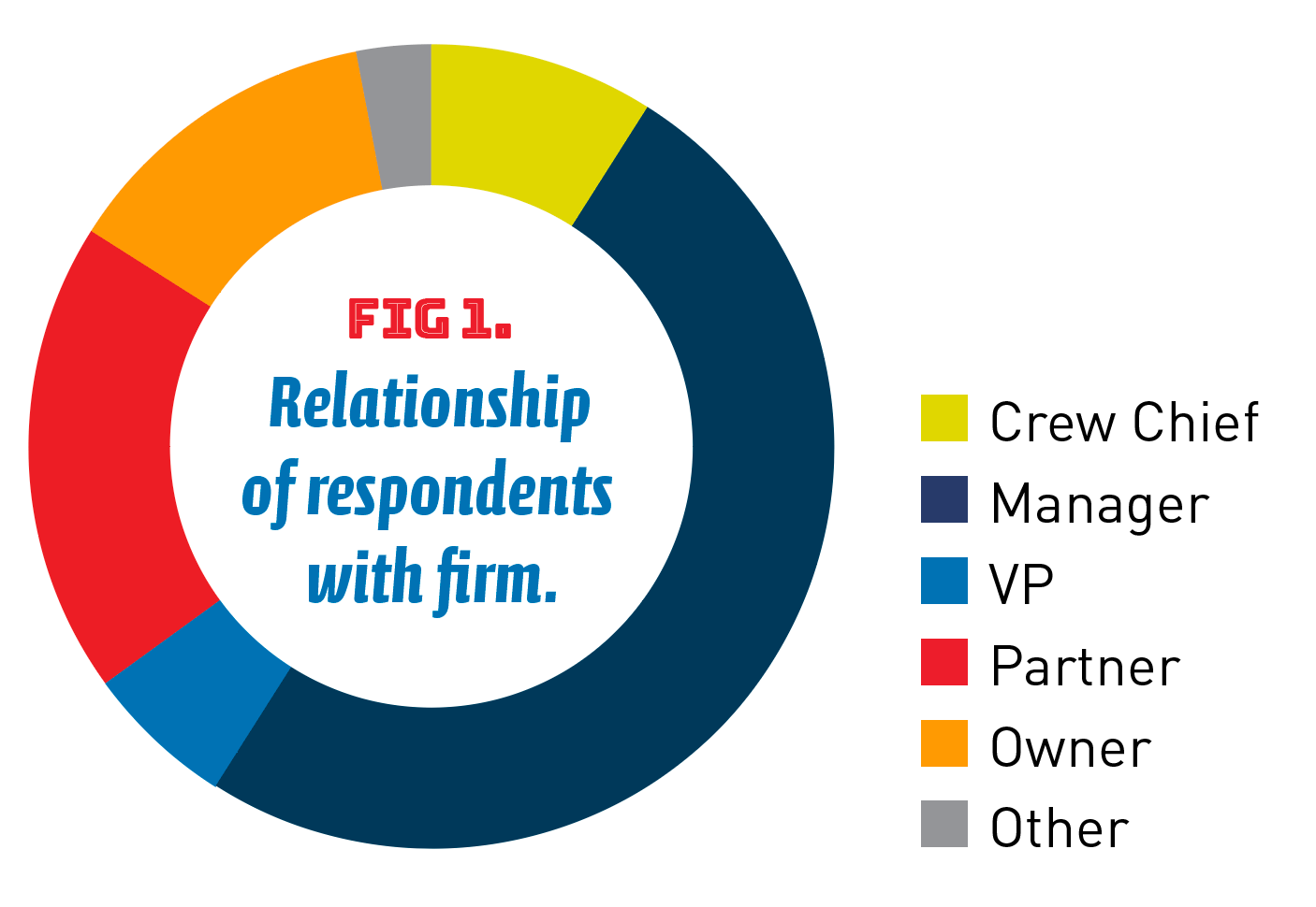
A very simple survey was created that asked five questions and was sent to my contacts. In total, 39 requests for information were sent out, from which I received 30 responses. The first question asked what their current position in their firm was. As shown in Figure 1, 12.5% listed themselves as the owner of their firm and 18.5% listed themselves as a partner in their firm. This relates to approximately 31% having full or partial ownership in a firm. Recognizing that in very large corporations, ownership is unlikely, the survey also asked how many were vice-presidents to which 6.3% of the respondents listed themselves as a vice-president in their firm. Altogether this means that 37.5% are primary leaders in their firms. Of the remaining responses, half (50%) listed themselves as managers of their firm’s survey division/group. Eight percent listed themselves as a crew chief and 9.4% listed themselves as other. It should be pointed out here that two of the graduates are instructors in surveying programs, four graduates work in federal agencies, and one works in a data management firm that deals with large data streams from the United States Geological Survey and others. What this question shows is that 81.3% of the respondents have leadership positions in their firm and are responsible for surveying operations in their firm. If you include the VP of companies, it would be 87.5%.
The second question asked how many graduates had a professional license. Recognizing that some are in positions that do not require a license, it was interesting to note that 80% stated they had a license while only 20% said they had no license. Besides the aforementioned positions that do not require a license, there was one graduate who did not have a license even though he had been working in the field for nearly 20 years. (WW – Fayettville, NY) This respondent works in the construction sector of surveying managing 3D models, machine guidance, and control for construction projects. However, the exam is principally centered on boundary surveying, and requires experience in boundary surveying. Thus, those working in construction, geodetic sciences, photogrammetry, remote sensing, and geographic information systems are not allowed to sit for the exam due to lack of experience in boundary surveying. The surveying profession needs to realize that licensure is for protection of the public, and these other areas should be allowed to sit for an exam that specializes in their area of expertise. This would be like the professional engineering exam where the professional exams test the person on their area of expertise, which restricts them to practice in their selected area. To think that someone working in construction surveying has nothing to do with public safety is simply not recognizing what an engineering design or judgement error in this sector of surveying could mean monetarily or to lives.
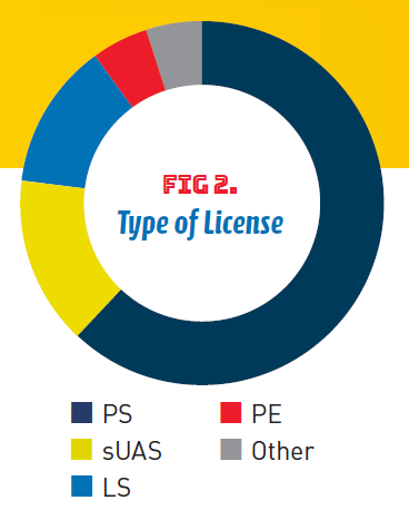
The next question asked what type of license the respondent had. It is important to keep in mind that it is possible for a respondent to have more than one of these licenses. As shown in Figure 2, 61.5% stated they had a professional surveyors license. With the creation of the surveying engineering degree in 2005, it was possible for graduates to obtain both a PE and PS license. Only 5.1% of the respondents obtained both licenses. Additionally, 15.4% stated they had a sUAS pilot license, and 5.1% stated they had some other license. The remaining 12.8% have passed the Land Surveying in Training (LS) exam, but either lack sufficient years of experience in boundary surveying or have no need for a professional license. Again, recognizing that not all graduates required a license in their job, it showed that most obtained a professional surveying license. Not only this but, as will be discussed later, many have surveying licenses in multiple states. In fact, one graduate was licensed in eleven states, or more than 20% of the country. (BB – Canonsburg, PA)
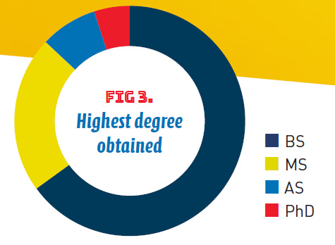
One of the goals of the program was to teach the students the importance of research and the value of advanced degrees. I did this by requiring writing throughout the program as well as giving students research topics starting in their second year in both programs. In fact, in their senior year, baccalaureate students were required to take a one-credit course where they researched a topic, prepared a paper on their research, and presented it to their peers. However, a limitation of the Penn State Surveying program was its inability to have a graduate degree. The next question asked the respondents what their highest degree was. As shown in Figure 3, 8.1% of the graduates listed their highest degree as an associate in science. All but one of these students graduated before the creation of the baccalaureate degree. As you would imagine, 64.9% listed the baccalaureate degree as their highest. However, 21.6% obtained a master’s degree and another 5.4% listed a Ph.D., which means that 27% obtained a post-graduate degree. This question showed that, even with the program’s limitations, it was able to produce students capable of obtaining a post-graduate degree.
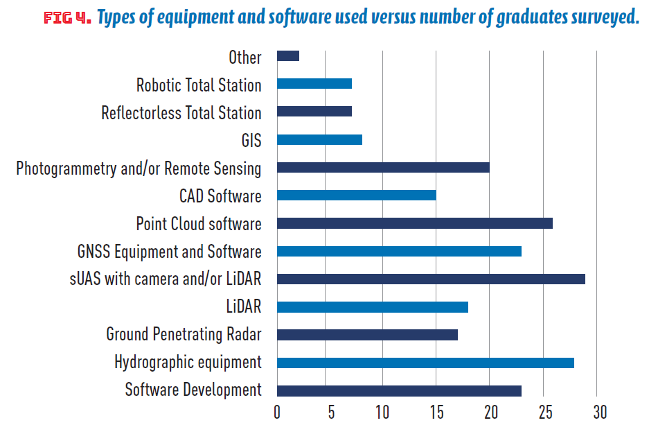
Since the first BS in Surveying students graduated when the program was in its infancy and with limited equipment, the last question was on the type of technology they used in their business. Again, this question allowed the respondent to select as many choices as was listed. As shown in Figure 4, 51 stated they used either a robotic and/or reflectorless total station. Seventeen respondents said they used GIS, as did eighteen state that they used photogrammetry and/or remote sensing. Of course, 29 used some CAD software and 23 used point cloud software. Twenty-six stated that they used GNSS hardware, while fifteen used small unmanned airborne systems (sUAS), and twenty used LiDAR. Eight graduates use ground penetrating radar, while seven used hydrographic equipment as were seven involved with software development, and finally two used surveying technology not listed such as a Tiny Surveyor to stake out well pads.
Sample Comments from Respondents
Most respondents emailed me to further discuss what they were doing. From this came some very interesting comments. Four of our graduates are working at the National Oceanic and Atmospheric Administration (NOAA) with three at the National Geodetic Survey (NGS) and another in NOAA Corps. Of the three graduates at NGS, one is the Field Operations Branch Chief, another is working on the rewriting of the OPUS software so that it uses multiple satellite constellations in its processing. So, in the future when you use OPUS remember who wrote the code. Sorry, but I am not sure what the third does. For the first eight years, the person working at NOAA Corps was a lieutenant on a hydrographic surveying vessel. However, he is currently finishing his master’s degree at Oregon State University. Another graduate is the vice-president of Global Positioning Services at Topcon Positioning Systems, Inc. He obtained an MBA, which is very appropriate for his position. Three of the graduates have been Pennsylvania Society of Land Surveyors presidents. One was a baccalaureate graduate from the Surveying program and the other two were associate degree graduates from my early days at Penn State. Two of these own their businesses. Two of our graduates are instructors themselves with one at Penn State in Civil Engineering and another at the British Columbia Institute of Technology—(BN, State College, PA and CG , Burnaby, BC,CA)
While the information on technologies shown in Figure 4 may not be surprising to the reader, it is essential that surveying programs around the country recognize the need to improve their in-house technologies. Often due to budgetary limitations, some of the newer technologies are not available to students. This was the case in my early surveying career. However, what this also shows is that with a strong technical background, a graduate can pick up technologies that didn’t even exist when they were in school. This is one of the advantages of having a baccalaureate degree with a strong technical, mathematics, and science background.
As was shown, most of the Penn State graduates obtained their license with the only limiting factor being the type of job they chose to pursue. However, with this stated, it should be realized that all are working in some field related to surveying. Currently, ten of the respondents had licensure in multiple states where one had licensure in eleven states, several had licensure in three or more states. As one of the respondents stated, “As for the degree itself, the 4-year surveying engineering degree cleared the literal roadblock to licensure for me in the states that require a degree to apply for survey licensure. My business partner, who is also a licensed PLS in Pennsylvania, was shut out of attempting several states because his degree was not a 4-year Surveying Engineering degree. My degree has opened more states to us, providing more opportunities for our employees and growing our business. Even for Pennsylvania, which doesn’t require the degree to become licensed, I don’t think I would have gotten through the exams as well as I did without all the knowledge, I gained in the Penn State Survey Engineering Program. The classroom exposure covered the variety of topics found on the exams…once I got into practice and specializing in land development surveying there simply isn’t the time for on-the-job exposure to all the other branches of surveying I would have needed to get through the exams.” (Chris Jackson, Pittsburg, PA) This is a second advantage of a baccalaureate surveying degree. It not only opens the graduate to the ability to become licensed in their home state, but also in several other states. This ability allows companies to pursue jobs beyond their state boundaries.
One thing I found interesting was two graduates, upon gaining sufficient experience, obtained their professional license and immediately started a one-person surveying business. The first to do this was an early associate degree graduate of mine. This firm now has partners and thirteen employees. The other was one of my last students. He holds a license in three states. (MB, Bradford Cty, PA).
Summary
I am sure that if other programs in the United States performed a similar survey, they would find similar results. It was not the intent of the authors to tout the success of Penn State surveying graduates, but rather to show the industry and perspective students what a degree in surveying can yield. I hope this shows doubters on the importance of a baccalaureate degree in surveying. A baccalaureate degree prepares students to excel in their chosen field and adapt to newer technologies. All professionals should support surveying programs around the country since it only makes the profession stronger. This support can come in many forms. One of the easiest and least costly methods is to recruit students into a program and provide these students with summer employment while they are in school. Most surveying programs in the country, and even in the world, are small in comparison with other programs in an educational institution. A small faculty cannot recruit areas as large as a state or even a region. Only professionals can do this at little cost to themselves. Visit high schools and discuss what is in this paper with students in high school. What a degree in surveying can mean to them and their future.
Another thing the profession can do is support surveying programs financially so that up-to-date technology can be purchased and studied in school. It is greatly appreciated that individual students receive financial assistance from many state societies, but the schools often also need assistance. For example, a manufacturer may provide a school with their latest and greatest technology with a 50% reduction in price, but even this is often too much for a program’s budget. Financial support will ensure that the graduates will have experience in the latest technologies to the benefit of their future employer.
Many surveyors believe they need a surveying degree program in their state or even in their part of the state. This is financially unviable. Again, all programs in the country and even the world are small in comparison to other degree programs in academic institutions. It would be much wiser to recruit students for existing programs, support these students financially with a summer job, and let them select their institution of choice. In fact, if you need summer help, go to a school, recruit students, and offer them a summer job to help them get through school. All you would need to do then is sort out those who want to get another degree from those who are interested in surveying as a profession. Upon graduation from a surveying program, you can offer them a job if it is needed. In essence, stop thinking that a program in your area of the world will provide you with a graduate, but rather recruit and support someone who is willing to obtain an education in surveying.
I hope this answers the question on what a baccalaureate degree in surveying offers a graduate and the profession, and what you can do to support the profession.
Drs. Ghilani and Seybert are professor emeriti from the Pennsylvania State University Surveying Engineering program.
Sidebar:
History of Survey Education at PSU
Surveying education at Penn State University began as an educational outreach activity to the coal mining industry in the Wilkes-Barre, Pennsylvania area in 1916. It coincided with the birth of the Penn State Wilkes-Barre campus, making that campus the oldest satellite campus in the Penn State Commonwealth Campus System. An actual degree in surveying did not come about until 1957 when the campus first offered the Associate of Engineering Technology in Surveying Technology. In October of 1962, the degree became the nation’s first accredited program in surveying technology when it received accreditation from the Engineering’s Council for Professional Development (ECPD), later known as the Accreditation Board for Engineering and Technology, and currently known simply as ABET. The Surveying Technology program later changed its name to Surveying Engineering Technology in 2012 to better align with ABET’s Engineering Technology Accreditation Commission (ETAC) program naming guidelines. In 1994, the Bachelor of Science in Surveying program was offered for the first time. It matriculated well with the associate degree program and received ABET accreditation under the applied and natural science accreditation commission (ANSAC). Later, in 2005, the baccalaureate program was changed to the Bachelor of Science in Surveying Engineering gaining accreditation with the ABET engineering accreditation commission (EAC). Currently, the surveying program still offers both the ETAC Surveying Engineering Technology program (2-year) and the EAC Surveying Engineering program (4-year). This paper is written from the experiences and viewpoints of two retired faculty in the surveying program at Penn State Wilkes-Barre.
Sidebars:
Comments By Tom Seybert
I became aware of the Surveying Technology program at Penn State Wilkes-Barre (PSWB) in August of 1982, when I was teaching mechanical engineering technology as an instructor of engineering at the Penn State Beaver campus. I met the PSWB surveying technology program coordinator at a Penn State engineering technology faculty meeting held at the University Park campus. Being a civil engineer teaching in a mechanical engineering technology program, I was very interested in learning more about the surveying program. Over the next seven years, I developed a working relationship with the surveying coordinator and one of the other surveying faculty. They were interested in me because of my interest in surveying and my educational background in stormwater management, a component of engineering surveys mentioned in the state registration law for surveyors. In August 1987, I took a leave of absence from Penn State Beaver and started pursuing my Ph.D. in Civil Engineering at Penn State University Park. I secured an instructor’s position teaching surveying to support my graduate studies. In the fall of 1988, the surveying program coordinator planned his retirement for spring 1989. He contacted me and asked if I was interested in applying for his position. I visited the Wilkes-Barre campus, and my impression of the program was positive, however I did not apply for the job because I wanted to complete my Ph.D. program before taking a permanent position in academia. Later, I found out that a guy by the name of Charles Ghilani had applied for and accepted the program coordinator position starting in August 1989. Little did I know at that time that we would become colleagues and very good friends over the next 30 years.
In January of 1996, while finally completing my Ph.D. I joined Chuck and the faculty teaching in the surveying program. I had the pleasure of teaching stormwater management to the first graduating class in the baccalaureate major. They graduated in May 1996. The class contained four students who had matriculated from the associate degree to the baccalaureate degree in 1994. I remained a member of the surveying faculty for 19 years until I retired in 2015. Over the years, Chuck and I (and other surveying faculty) taught many surveying students in the baccalaureate program. We have had the pleasure to witness their success in the profession, however the success of these graduates has never been formally documented. This paper is an effort to show their success in a concrete form.
Comments by Chuck Ghilani
In August 1989, I came from the University of Wisconsin, Madison and began teaching at Penn State in the Surveying Technology program. When I started, members of the Pennsylvania Society of Land Surveyors (PSLS) told me that the program graduates were not able to pass the state’s professional land surveyor licensing exam. I was asked on nearly my first day on the job, “What are you going to do?” It was obvious that given the technology and the breadth of expertise covered in the licensing exam that the associate degree program was insufficient to meet the needs of the profession. Additionally, I quickly realized that most of the students in the associate program had the ability to obtain a baccalaureate degree but did not have access to that opportunity. So, in 1994 the Bachelor of Science in Surveying program was created through my efforts and the efforts of other surveying program faculty. At the same time, the associate degree program was revised to better fit the current practice. By design, the baccalaureate degree included the same surveying courses that the associate degree required, making the matriculation of the associate degree graduates to the baccalaureate degree conveniently streamlined. The major difference in the baccalaureate degree was the obvious additional two years of surveying instruction, and the required courses in advanced mathematics. However, this baccalaureate program allowed students to conveniently use their associate degree science courses since it went for an applied and natural science accreditation (ANSAC) instead of an engineering accreditation (EAC). However, this decision to seek the ANSAC accreditation also short-changed the students who were essentially in an engineering curriculum but not getting recognition for it. So, in 2005 the program made the necessary science modifications and received an EAC accreditation with the new program name of Bachelor of Science in Surveying Engineering.