“All maps state an argument…”
—J. B. Harley, 1989
There’s a popular poster of the world composed of satellite images, with continents arrayed horizontally like the Mercator wall map we knew in grade school. While in a store once, I laughed at a sign that touted this poster as “The Most Accurate Map of Earth.” Putting aside the distortions of a flat map, surveyors know that claims of accuracy depend on context and purpose. This is not the map you’d want in your glove compartment to find a route to Decatur.
Woodcut map of Tenochtitlán, Second Letter of Cortés. Nuremberg: 1524. NEWBERRY LIBRARY
That sign in the store seemed almost reverential that photos from space promise something true and unbiased. But the poster plainly perpetuates our traditional frame of East and West since the Americas could just as accurately be on the right-hand side or the entire thing upside down. As for truth, consider the choice to view the world from such a distance, without borders or place names, where green, brown, deep blue and icy white surely obscure all traces of civilization, along with the harm humans have done.
Facsimile by Tlaoli Ramírez Téllez, 2021, of Map of Zolipa Misantla, Veracruz, 1573. Original at Archivo General de la Nación (AGN) Mapoteca no. 1535. COURTESY LACMA
The nonverbal messages enfolded in maps figured prominently in three compelling Los Angeles art exhibitions in 2022. Broadly, they dealt with colonial rule following the Spanish conquest of Mexico and its lasting reverberations, and they expanded the usual narrative of that often violent clash of worldviews. Through selections of historic and contemporary maps, the exhibitions highlighted Indigenous perspectives, revealing a surprising interplay of cultures and a resilient people who never ceased expressing themselves through art.
Mixpantli
The ancient fire god of the Mexica (pronounced mə·shee·ka)—the nation we know as the Aztecs—stood watch over a gallery of colonial-era maps at the Los Angeles County Museum of Art (LACMA). The basalt statue was carved perhaps 700 years ago by Nahua artists, members of the Indigenous people of Mexico, and was among artifacts that provided a pre-Columbian lead-in for the exhibition, Mixpantli: Space, Time, and the Indigenous Origins of Mexico. The word Mixpantli describes a celestial comet, a portent of the 1519 Spanish invasion as set down by Nahua scribes.
Detail from Map of San Juan Cuauhtinchan, Puebla, 1704. AGN Mapoteca no. 655. ARCHIVO GENERAL DE LA NACIÓN
More than works of art, the maps in the exhibition tell a legal story that is part and parcel of colonial history. They belong to a corpus of Spanish land grants and court documents called the Ramo de Mercedes, housed in Mexico’s Archivo General de la Nación (National Archives). Spanish for mercy, merced refers to grants considered to have been graciously given “at the sovereign’s mercy” (Tyler, N.M. Hist. Rev., 1991). The king established the colony of New Spain across the subjugated Aztec empire and empowered his viceroy to grant title to land, predominantly for farming and ranching (Taylor, N.M. Hist. Rev., 2021).
Map of Santiago Atapan, Michoacán, 1728. AGN Mapoteca no. 687. Sun denotes east and star denotes north. Roads with mojoneras (milestones) topped with crosses give distances in leagues to nearby pueblos. ARCHIVO GENERAL DE LA NACIÓN
Because the original maps remain in Mexico, Mexico City-based artist and designer Tlaoli Ramírez Téllez recreated them for LACMA. They are called facsimiles, but that label doesn’t do them justice. Meticulously drawn with acrylic, ink, and watercolor on paper, they replicate the originals’ signs of age in every detail, from water and wine stains to frayed edges, crumbling creases, and revealing palimpsests. These are skillful forgeries of official maps, authenticated with signatures and annotations scrawled by colonial functionaries.
Indigenous communities could and did use the land grant legal system to protect their own interests, sometimes to fight encroachments and dispute water rights with colonial estate holders, as was the purpose behind the map of Santiago Atapan (gorgeously fringed with golden fields), and to secure grants for preexistent pueblos (Museo Amparo). But more often, piece by piece, land grants were the means of transferring Indigenous-held territory into Spanish hands (Rull, 2020, pp. 14, 192).
Hybrid
The mapas de mercedes de tierras (land grant maps) were presented as key evidence in land cases before the viceroyalty courts. Although the legal system was imported, a rich tradition of mapmaking was local. We know from Spanish sources that conquistadors had been given Nahua maps to help them choose where to drop anchor and find their way in unfamiliar territory (Alva, Historia Chichimeca; Mundy, 1998).
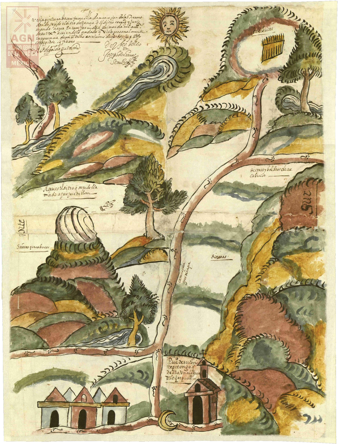
Map of Ahuehuetitlán, Oaxaca, 1616. AGN Mapoteca no. 2056. At the pointing hand symbol it reads: “Here is the site …” ARCHIVO GENERAL DE LA NACIÓN (AGN)
The parties requesting and opposing land grants commissioned Indigenous artists to paint maps, whose great variation in style is attributable in part to the meeting of cultures. Artists raised in Mesoamerican traditions became trained in European techniques, and they integrated these different approaches with unique results (Hidalgo, 2019, Ch. 2; Rull, p. 50).
Indeed, the exhibition highlighted the “hybrid nature” of these artistic legal documents that emerged in a time of transformation. As artist Mariana Castillo Deball explains, although land grant maps were meant to serve the Spanish system, “we can still recognize the voice and ways of representing things by the Indigenous painters.”
For example, a 1704 map of San Juan Cuauhtinchan is characterized by rectilinear, church-centered blocks that conformed to the king’s decree to his land surveyors: “Let the city lots be regular from the start, so that once they are marked out the town will appear well ordered; … otherwise order will never be introduced” (A.E.J. Morris, 1994).
Even then, nearly two centuries after the Aztec defeat, the Nahua mapmaker incorporated an expression of defiance in his drawing: overlooking the village, atop a green hill of the Sierra de Amozoc, we see a raptor clutching a fawn in its talons and a snake in its beak. In Nahua iconography eagles symbolize elite warriors, and the captive snake recalls a legend of the founding of Tenochtitlán, the Aztec-Mexica capital—a scene that lives on at the heart of the Mexican flag.
Mexico’s hybrid culture is especially evident in the sixteenth-century Florentine Codex (the exhibition included UCLA’s reproduction). This monumental, illustrated, bilingual (Spanish and Náhuatl) primary source for Mexica history and culture represents the collaboration between a Franciscan friar and a team of Indigenous writers and artists. It is poignant that their work to preserve Nahua collective knowledge was pursued during a horrific epidemic that decimated the native population.
Contemporary Echoes
The second exhibition was LACMA’s companion show, Mixpantli: Contemporary Echoes, where the artworks connected past to present. Dominating the gallery floor was a map by artist Deball that visitors could physically walk upon. Its title, Vista de Ojos (lit., view from eyes), is a term borrowed from a land grant procedure that required visual confirmation by colonial officials of those locally drawn maps discussed above. This government review of the artist’s view of the land—placing in relationship the subduer and subdued—Deball poetically calls a “gaze on top of a gaze.”
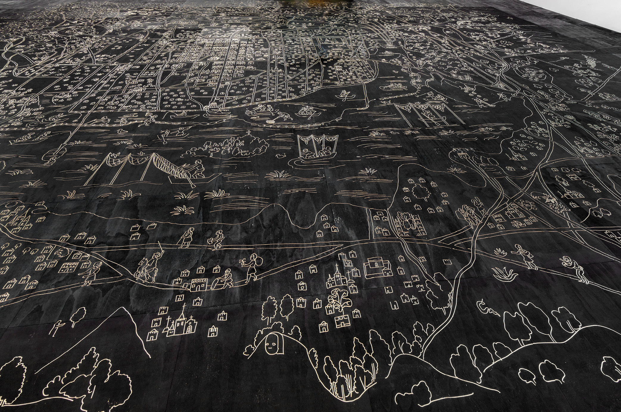
Mariana Castillo Deball. Installation view of Vista de Ojos, 2014. CNC engraved plywood floor. Kurimanzutto, Mexico City. PHOTO BY ESTUDIO MICHEL ZABÉ. Courtesy the artist
Measuring 19 by 13 meters (2,659 square feet), Deball’s incised plywood panel flooring is an enlarged rendition of the historic Santa Cruz Map of Tenochtitlán, by then renamed Mexico City. Produced only three decades after the Conquest, that map shows European-style buildings in place of Aztec temples, and uses animals, stars, and other symbols to identify Mexica place names. Based on what suggests an insider’s familiarity with the city, the mapmaker was likely “an Aztec with European schooling” (Lib. of Congress, CN 2021668313).
Deball, born in Mexico City, writes of the Santa Cruz Map, “On the outskirts one can see the Indigenous settlements and their inhabitants engaging in everyday activities,” such as fishing, canoeing, and bowhunting. She sees in these traditional lifeways a contrast between Indigenous and European maps in outlook and approach, which the other exhibition’s title, “Space, Time,” references. Whereas European maps focus on spatial information frozen in time, Indigenous maps are populated with people and stories, actions we imagine projecting into the past and future. Deball’s walkable installation (in LACMA’s permanent collection) invites visitors to set foot on the map and experience it with more than just a gaze.
Both the Santa Cruz Map and its modern rendering testify to Indigenous continuity, countering the misconception that Conquest meant obliteration. The “myth of native desolation” is what historian Matthew Restall terms the notion that those not readily destroyed through battle or disease soon surrendered their ethnic identities under the weight of Spanish colonizers, culture, and control. On the contrary, Restall elaborates on the resourcefulness of those Indigenous people to survive and adapt, as the maps in these exhibitions bear out.
Maya Blue
Contemporary Echoes also showcased paintings by Southern California artist Sandy Rodriguez that uncomfortably challenge us to see the through-line from the Spanish invasion to today’s news. Rodriguez describes herself as a Chicana who, owing to her family and proximity to the border, grew up in two worlds. Using amate paper and natural pigments (e.g. indigo leaf extract and clay to form Maya Blue), she draws from the palette and vocabulary of historic maps to link colonialism with national immigration policy.

Sandy Rodriguez. Detail from De las Señales y Pronósticos & I.C.E. Raids de Califas, 2018. Hand processed watercolor on amate paper. Crystal Bridges Museum of American Art, Bentonville, AR. COURTESY THE ARTIST
Filled with Mesoamerican iconography, Rodriguez’s works confront the viewer with police violence and the incarceration of Latino immigrants. Her painting, De las Señales y Pronósticos and I.C.E. Raids de Califas (Of the Signs and Prophecies and I.C.E. Raids in California [slang]), presents a map of the state, with satellite views of detention centers plotted onto the desert borderlands. Rodriguez explains that her colors and style reference images of the Conquest in the Florentine Codex, in which Spanish galleons are upgraded to immigration enforcement helicopters sporting the menacing visages of calevaras (skulls).
Códice Maya
Although it’s not a map, the ancient Códice Maya is relevant to the topic of Indigenous culture, and its showing at the hilltop Getty Museum coincided with the third exhibition we will cover. This manuscript on bark paper tracks the movements of the planet Venus—the Morning Star—as recorded by Maya priests around the peak of Maya civilization, 400 years before Spanish contact and centuries before Tenochtitlán existed. On loan from Mexico, the codex employs pictorial symbols and imagery, like a graphic novel, and documents the sophistication of ancient astronomy and the Maya calendar.
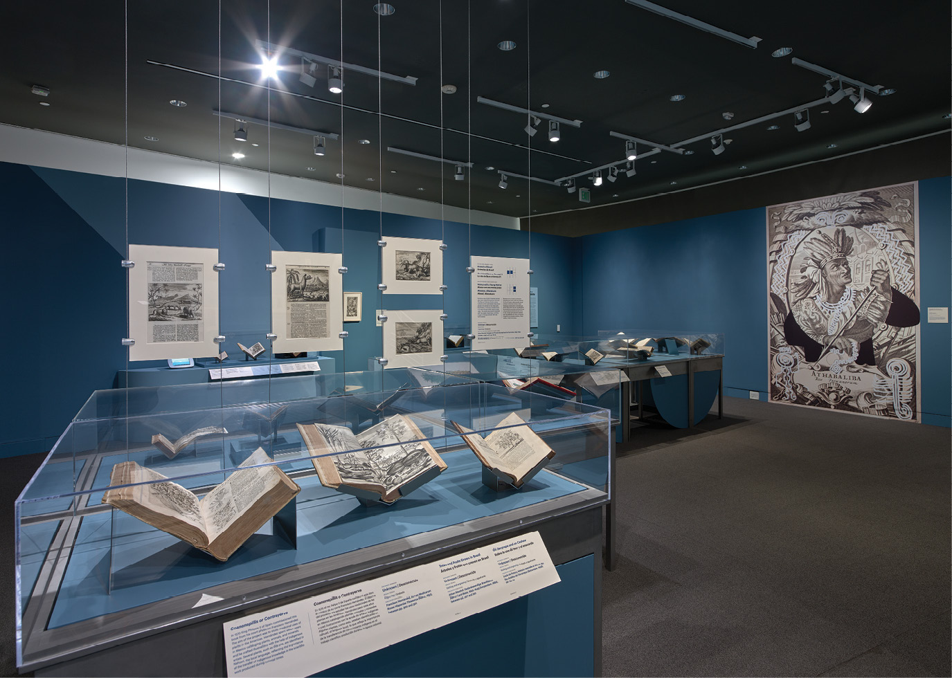
Installation view of Reinventing the Americas: Construct. Erase. Repeat. 2022, at Getty Research Institute. PHOTO BY JOHN KIFFE, © J. PAUL GETTY TRUST
Reinventing the Américas
We conclude with Reinventing the Américas: Construct. Erase. Repeat., at the Getty. There, a fine woodcut map of Tenochtitlán from 1524 displays the mix of styles seen in the Mixpantli exhibition. (See this magazine’s cover image.) Its label pointed out a motif that resembles the Aztec Náhuatl glyph, tepetl, representing a hill or mountain, while, markedly less subtle, this “map of conquest” flaunts the triumphal coat of arms of Charles V, then Holy Roman Emperor and King of Spain.
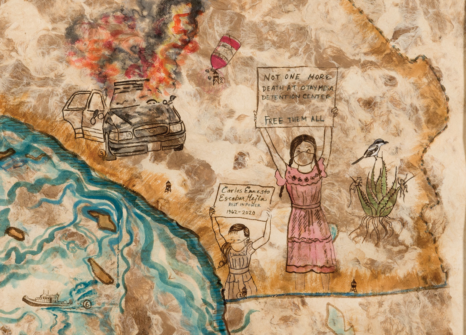
Sandy Rodriguez. Detail from Mapa de Califas—Atrocities, Isolation and Uprisings, 2021. Hand processed watercolor on amate paper. COURTESY THE ARTIST
This exhibition began with the premise that America is more than a place on a map; it is an idea that, since Columbus, was defined by Europeans. To illustrate, a 1619 map of the Straits of Magellan by Flemish engraver Theodor de Bry features naked native figures as Adam and Eve, representing the New World as Eden, a blank slate waiting to be graced with knowledge and civilization. Such Eurocentric portrayals persisted for centuries, “fueling stereotypes and prejudices” against Indigenous peoples (Getty.edu). The purveyors of this view, it seems, were unacquainted with Maya astronomy.
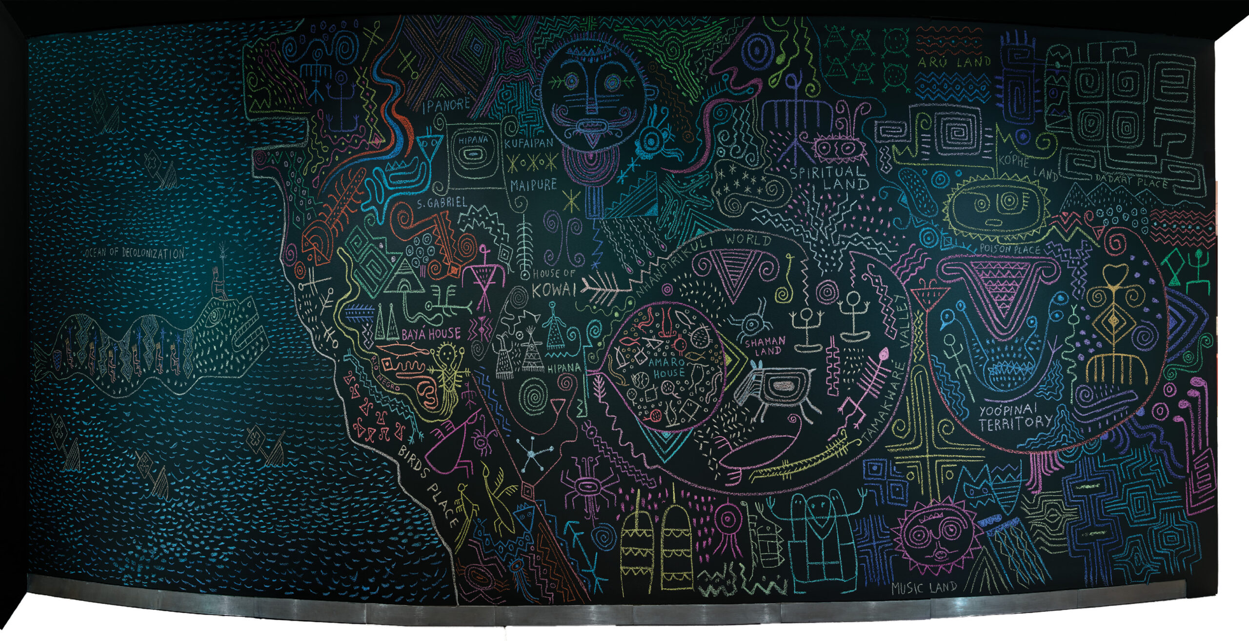
Denilson Baniwa. Untitled, 2022. Chalk mural, at Getty Research Institute. PHOTO BY JOHN KIFFE, © J. PAUL GETTY TRUST
In keeping with the theme of reinvention were contemporary works in a variety of mediums by Indigenous artist Denilson Baniwa. Originally from the Brazilian state of Amazonas, Baniwa describes his work as reflecting on both his home village and the outside world where he now lives and the “frictions that occur when these worlds collide,” including those caused by differing “understandings of the world,” its origins, and our place in it.
The exhibition included his videos, paintings, and “digital interventions”—in which copies of historic depictions of the New World appear altered or defaced. In a piece titled History of Violations, Baniwa blacked out, as if by Sharpie, the European-assigned place names on a renowned 1579 map of the Americas by Abraham Ortelius. And in a wall mural in chalk, Baniwa offered his own map, reclaiming history from an Indigenous point of view, if somewhat cryptically, in the style of ancient petroglyphs.
Contested Lands
Sandy Rodriguez refers to the subject of her map paintings as “contested lands.” One might say that all the maps in these exhibitions, from colonial to modern, in various ways pose the challenge: who belongs here? And just as land is often contested, so is history. Those elegant Spanish land grant maps are inescapably tied to a history of Indigenous communities dispossessed by way of an avaricious legal system. At the same time, because the mapmakers’ skills were highly valued by the conquerors, the maps impart to us a cultural legacy and the human spirit to survive.
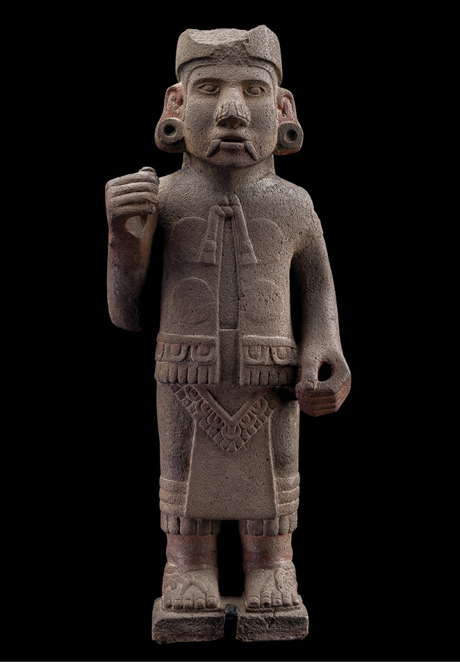
Xiuhtecuhtli, ca. 1250-1521, Mexica. Basalt stone (Ht. 80 cm). Museo Nacional de Antropología, Mexico City. INAH DIGITAL ARCHIVE
Survival was a recurring theme in these exhibitions, culminating in the vibrant expression of Indigenous experience in contemporary art. This theme is palpable in the Florentine Codex: amid staggering death and destruction, its Nahua authors and artists resisted their plight and affirmed their presence on the land. Five hundred years after the Conquest, their prefatory words still hold the power to move us: “We people here ….”
Bibliography
Alex Hidalgo, Trail of Footprints: A History of Indigenous Maps from Viceregal Mexico (Univ. of Texas Press, 2019).
Matthew Restall, Seven Myths of the Spanish Conquest (Oxford Univ. Press, 2021).
Ana Pulido Rull, Mapping Indigenous Land: Native Land Grants in Colonial New Spain (Univ. of Oklahoma Press, 2020).
On View
See related maps, art, and artifacts at these museums:
Latin American and Pre-Hispanic Art Collections at the Getty Center in Los Angeles.
Art of the Ancient Americas Collection at the Los Angeles County Museum of Art. Works by Mariana Castillo Deball and Sandy Rodriguez are in the museum’s permanent collection.
Paintings by Sandy Rodriguez are part of the installation, Borderlands, at the Huntington Library Art Museum in San Marino, CA. Her solo exhibition, Unfolding Histories: 200 Years of Resistance, is at University of California, Santa Barbara until March 3, 2024.
Colonial maps from the 2018 exhibition, In Tlilli, In Tlapalli. Images of the New Land: Indigenous Identity After the Conquest, at Museo Amparo in Puebla, Mexico, can be viewed on the museum’s website.