This article addresses the need to prepare a new boundary description of a tract once the survey and plat of the tract is complete. Some in the title industry opt to use the record boundary description in a subsequent conveyance, ignoring the “new” surveyed description. The article is for the usual boundary survey project where a surveyor is asked to survey a tract described with a metes and bounds description. (Not a parcel described by aliquot part of the USPLSS or a lot/block/subdivision description.) The provided description could have been prepared many years ago, or fairly recently. The tract may or may not have been previously surveyed. The survey is being made in preparation for the next conveyance.
The Boundary Description
The purpose of the boundary description is to identify with specificity and certainty the lands conveyed. Every conveyance of real property requires a sufficient one, for if not the conveyance could be void. The boundary description is the core of the professional surveyor’s work. One purpose of preparing a “new” description of a surveyed tract is to best memorialize its location.
Provided a deed, the surveyor’s task is to locate the boundaries of the described tract. This is done by taking measurements, locating and evaluating evidence, considering the record adjoiners, applying the legal principles of boundary location, confirming or monumenting the tract corners, then preparing the plat of survey and, importantly, preparing a new boundary description of the surveyed tract. All in compliance with applicable survey standards.
Any metes and bounds tract properly surveyed (or resurveyed or “retraced”) should be redescribed and that description used in the subsequent conveyance. The future location of the tract is best served by using the latest survey description. There are so many good reasons for this: Better measurements for distance and direction, new/upgraded monumentation, record adjoiner changes, ambiguities eliminated. The provided description may be very nearly wholly inadequate to locate the tract. For riparian tracts there could be very large boundary location differences and associated acreage changes. The severity of the differences between the “old” and “new” descriptions will be highly variable, and perhaps a function of age, the abilities of the previous surveyor (if surveyed), etc., but any resurveyed tract should be redescribed and that description used in the subsequent conveyance. Subsequent owners will benefit. The boundary description memorializes the tract’s location. One written on completion of a survey best serves that purpose.
A Disturbing Trend
But it seems some in the title industry elect not to use the surveyor’s “new” provided description of the surveyed tract in the subsequent conveyance. Instead the “old” record description is repeated in the next conveyance, ignoring the surveyor’s “new” boundary description. The reason given for this choice by the title industry is that by using the new description the tract loses its title identity or that the reviewer doesn’t know or can’t tell that the “new” described and the “old” described lands are the same tract. Usually the “new” description will be such an improvement in locating the tract boundaries that any reason not to use it seems nonsensical. This practice of conveying using the old, record description is a bad one.
Overcoming the “Title Identity” Reason
The boundary survey concludes with a plat of survey and a boundary description crafted by (or one checked and approved) the professional surveyor whose seal is affixed to the deliverables. Some state survey standards require a boundary description be prepared for each boundary survey conducted.
Every plat of survey (in some states referred to as a Certificate of Survey) should include a set of Surveyor’s Notes that further explain the survey. Among those notes absolutely should be one that says something like “The lands surveyed, platted and described hereon are the same lands as described in….” Then quoting the record document recording location. This statement should be a requirement of every state’s survey standards. This statement ties the survey and its boundary description to the record description. (There are exceptions and amplifications to this.) Or, at the conclusion of the new surveyed boundary description, one could add the statement “Being the same lands previously described in….” (Quoting the record document.) Either of these methods should respond to the title industry’s complaint about the next conveyance losing title identity.
Good Professional Practice
Today’s modern boundary description should conclude by calling for the survey. Something like “…the above described tract contains XX.XX acres, more or less, per plat of survey number XXXX dated MO/DAY/YEAR by XXXXXXX Survey Company, Inc.” If this description is used in a deed, this call for the survey incorporates all the information shown on the plat as a part of the conveyance, to be used and considered in future surveys of the tract. Hopefully the plat of survey is recorded (but that subject is left for another time).
Surveyors and the surveying profession cannot direct or dictate the title industry’s business practices. What surveyors can do is use the following best practices: 1.) In Surveyor’s Notes quote the record location of the deed, the survey of which is represented on the plat. 2.) In the new surveyed description call for the survey. 3.) On the resulting plat of survey, place the “new” description AND the “old” record description, labeling them as such. By this, other professionals involved in the real property transfer can choose which description they wish to use in the subsequent conveyance. If the seller’s attorney insists on using the “old” record description in the conveyance by Warranty Deed, one may suggest the tract also be conveyed using a later Quit Claim Deed containing the “new” description. At least by that method the new, surveyed description gets into the record. 4.) Record the survey.
After this effort, the professional surveyor has provided the best information he or she can concerning the tract and its future conveyance, to benefit the current and future sellers, buyers, lenders, insurers, adjoiners and surveyors. It can do no more. One would hope the title industry would embrace and use our professional services.
Sidebars
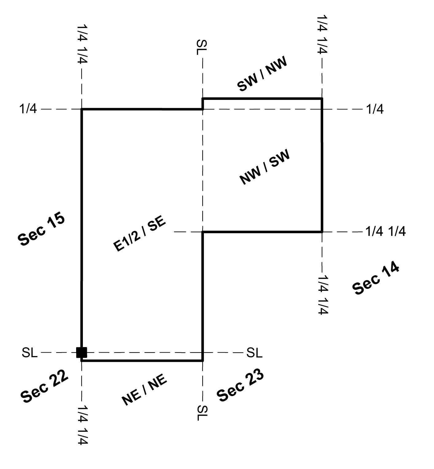
Record description of lands. Description is from current owner’s deed. Description first used in the early 1900’s and repeated ever since. Read it carefully and try to plot. Notice anything that should be corrected.
All of the Northwest Quarter of the Southwest Quarter of Section 14 and the East half of the Southeast Quarter of Section 15, T41N, R8W, 5thPM, containing 120 acres more or less. AND four acres off the South side of the Southwest Quarter of the Northwest Quarter of Section 14, T41, R8W; a fence along the Northern boundary of said 4 acres to be the line; said fence to belong to the grantee herein. AND about 13/16ths of an acre in the Northwest corner of the Northwest Quarter of the Southwest Quarter, the fence on the North and ditch on the East to be the lines. AND, commencing at the section corner of Section 15, 16, 22 and 23, T41, R8W, thence south on the section line between sections 22 and 23 one chain to a limestone set for a corner, thence West var. 4 degrees 44 feet East 20.22 chains to a limestone 24 inches long, thence North var. 6 degrees East one chain to a stone set for Northwest corner of the Northeast Quarter of the Northeast Quarter thence East var. 4 degrees 44 feet East 20.22 chains back to the place of beginning, containing 2 acres more or less.
Following a survey of the lands, the surveyed description. In the next conveyance of these lands which should be used? The record or the surveyed description?
All of the Northwest Quarter of the Southwest Quarter of Section 14, and, all of the East Half of the Southeast Quarter of Section 15, and, a fractional part of the Southwest Quarter of the Northwest Quarter of Section 14, and, a fractional part of the Northeast Quarter of the Northeast Quarter of Section 22, all in Township 41 North, Range 8 West of the 5th P.M. described as follows: Beginning at the Southeast Corner of the Southeast Quarter of the Southeast Quarter of said Section 15; thence North 0°42’10” East, 1327.46 feet along the East line of said Southeast Quarter of the Southeast Quarter to the southwest corner of the aforesaid Northwest Quarter of the Southwest Quarter of Section 14; thence South 89°12’18” East, 1329.26 feet along the South line of said Northwest Quarter of the Southwest Quarter to its southeast corner; thence North 0°47’47” East, 1321.42 feet along the East line of said Northwest Quarter of the Southwest Quarter to the southeast corner of the aforesaid Southwest Quarter of the Northwest Quarter of Section 14; thence North 0°50’36” East, 131.26 feet along the East line of said Southwest Quarter of the Northwest Quarter to the southeast corner of a parcel described in Hance County Deed Records at Book 321, Page 46; thence North 89°21’21” West, 1326.42 feet along the South line of said Book 321, Page 46 parcel to the West line of the aforesaid Southwest Quarter of the Northwest Quarter of Section 14; thence South 0°37’26” West, 131.26 feet along said West line to the northeast corner of the Northeast Quarter of the Southeast Quarter of the aforesaid Section 15; thence North 89°01’26” West, 1331.72 feet along the North line of said Northeast Quarter of the Southeast Quarter to its northwest corner; thence South 0°55’40” West, 2652.70 feet along the West line of the aforesaid East Half of the Southeast Quarter of Section 15 to a found stone at the northwest corner of the aforesaid Northeast Quarter of the Northeast Quarter of Section 22; thence South 0°42’18” West, 66.00 feet along the West line of said Northeast Quarter of the Northeast Quarter to the northwest corner of a parcel described in Hance County Deed Records at Book 291, Page 41; thence South 89°20’16” East, 1337.26 feet along the North line of said Book 291, Page 41 parcel to the East line of the aforesaid Northeast Quarter of the Northeast Quarter of Section 22; thence North 0°10’16” East, 66.00 feet along said East line to the point of beginning. Above described tract contains 127.29 acres, more or less, per plat of survey R1682, dated February 22, 2023, by Recherche Surveying.