When Eugene Skinner settled in the Willamette Valley in 1846 he was warned about the flooding of the Willamette River. The Kalapuya natives showed him where to build his cabin on the butte known as “Ya-Po-Ah”. This cabin, as built by Skinner, was the basis for his Donation Land Claim. Over time the butte was almost fully transferred into the hands of Doctor Thomas Winthrop Shelton and his wife Adah. Eugene became a prominent city, home to the University of Oregon, and Ya-Po-Ah became Skinner Butte. The Shelton family built the “Castle on the Hill” on the South base of the Butte, but Skinner Butte is known for so much more. In November of 1888, the University built an Astronomical Observatory on the Butte. In 1894 this observatory would be used by United States Geological Surveyor and Astronomer Samuel Stinson Gannet to determine precise latitude and longitude defining the basis for all control in Southwest Oregon and the Willamette Valley.

Photo GN6125 “Man with telescope inside University of Oregon observatory, ca. 1895” Courtesy of the Lane County Historical Museum.
The University’s third building, the Astronomical Observatory, was designed after its first—Villard Hall. In fact the same famous Portland architect designed all three—Warren Heywood Williams. The observatory was a simple 18 foot by 40 foot structure made of brick, cement and stone. The roof had two openings with a rope and pulley system that opened up access to the night sky. Long before the observatory was built the University started collecting equipment. Authorized on June 20, 1878 the Secretary of the Board of Regents travelled to Philadelphia to purchase a solar compass, an astronomical clock, a telescope and other supplies totaling $4000. The instruments were delivered by train soon thereafter and placed in storage for the next ten years.
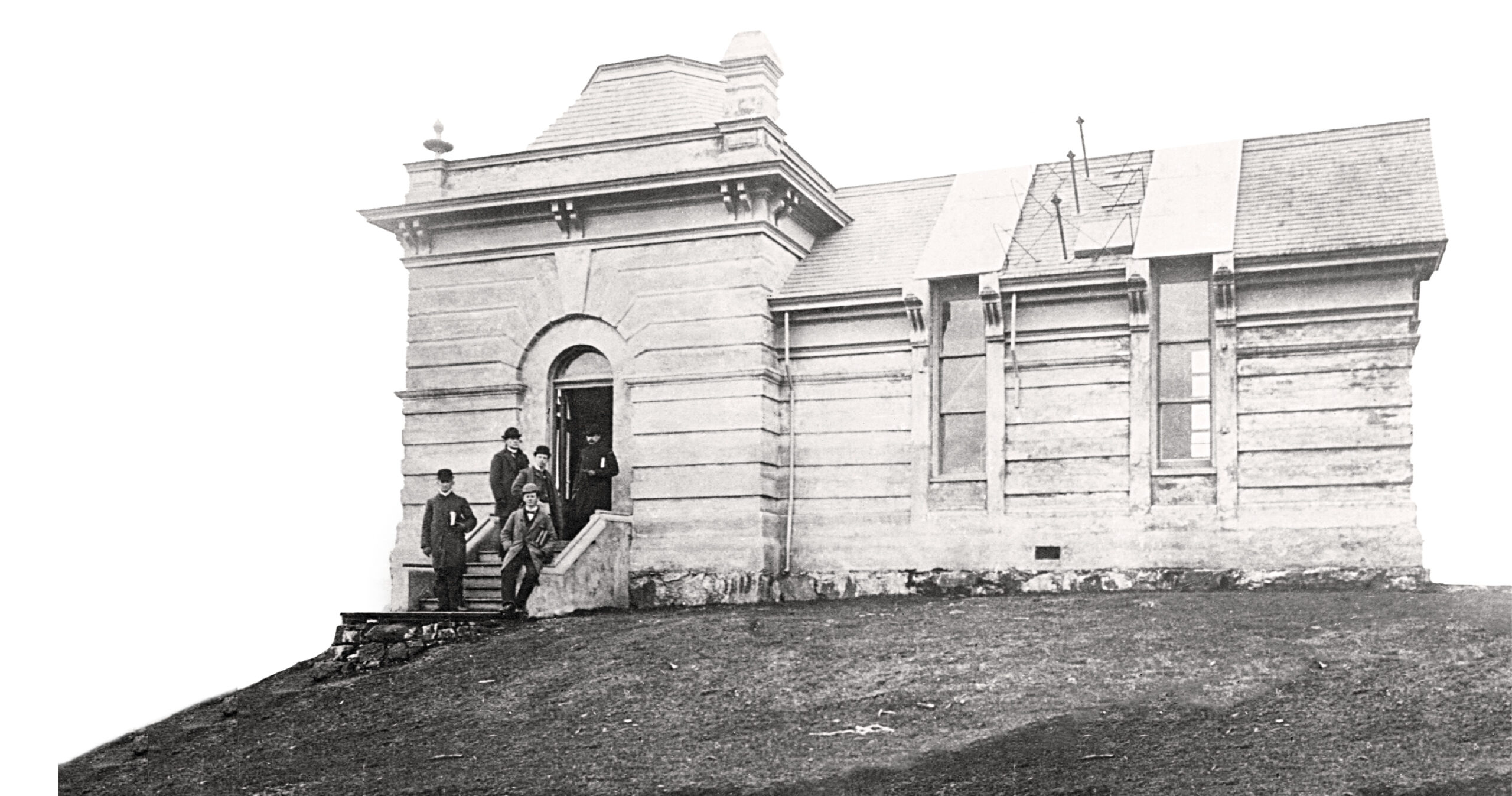
Photo GN292 “University of Oregon observatory, ca. 1890” Courtesy of the Lane County Historical Museum
The board at the University could not agree on a location for the new observatory and their prime location, Skinner Butte, was not an option. At a meeting on August 30, 1888 it was reported that the negotiations with Doctor Shelton to place the observatory on Skinner Butte have failed. The minutes of that date state “…we made an effort to purchase the land of him but could not get him to consent to sell at any price.” On the dreadful night of November 26, 1887 the “Castle on the Hill” caught fire. A train blocked the road crossings, therefore no firefighting equipment could reach the site and the entire house burnt to the basalt foundation. Reluctantly Doctor Shelton decided to rebuild but it was soon realized money was running short. With the construction coming to an end and the University waving money in his face he signed the deed over to The Regents of the University on September 28, 1888.
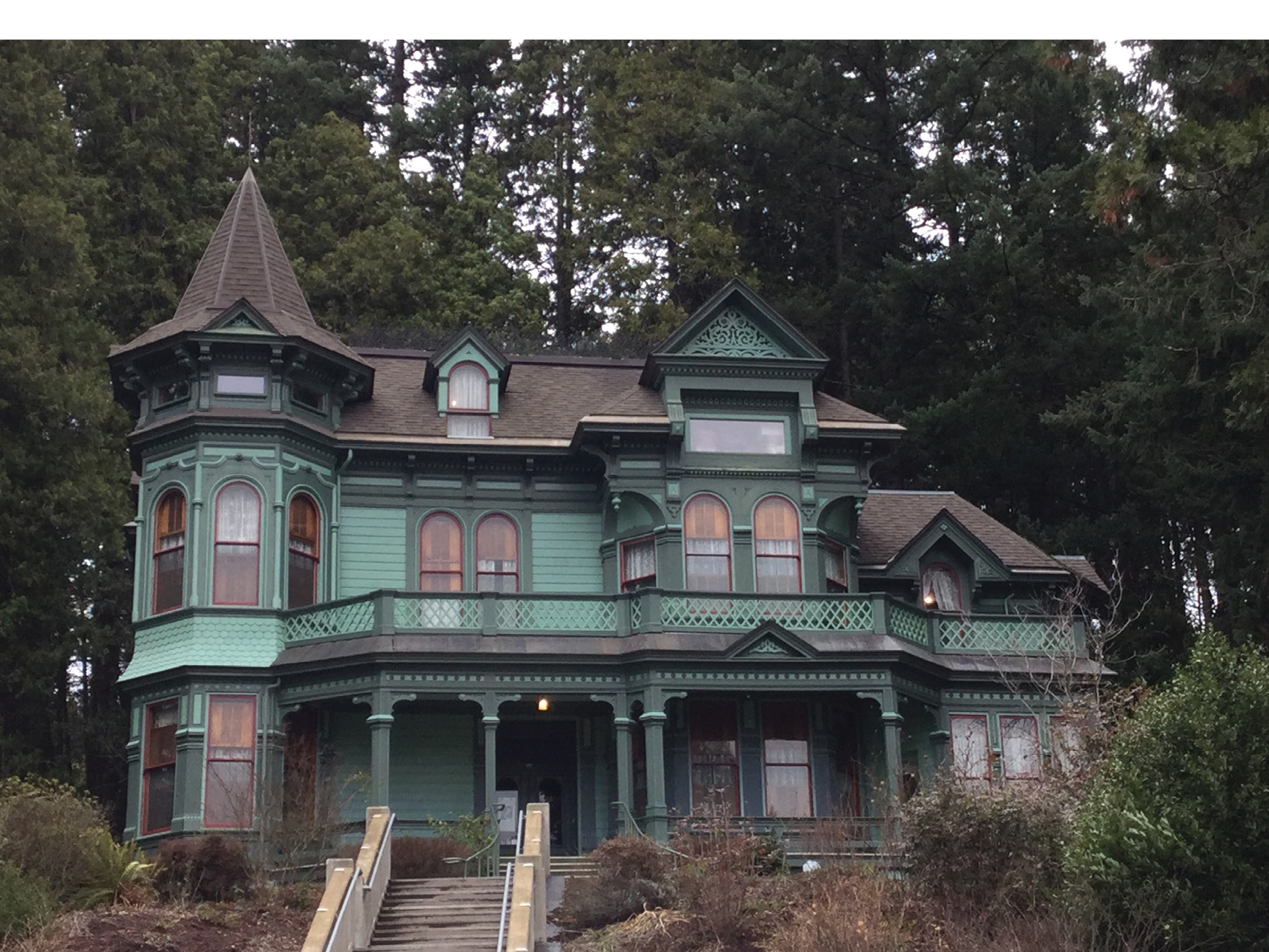
The Shelton-McMurphey house aka Castle on the hill. Photo by the author.
The house was completed soon thereafter in October. The deed, as recorded in Volume T, Page 508 & 509 of the Lane County Records, recites all the details of the 180-foot x 100 foot parcel for the site of the new observatory. The deed also includes a “free and perpetual right of way for egress and ingress from and to said tract to be suitable for foot passengers and vehickles (sic), beasts of burden and other animals. Said way to course by the most practicable route with a public street of said Eugene City in a manner to do the least injury to said Grantors.”
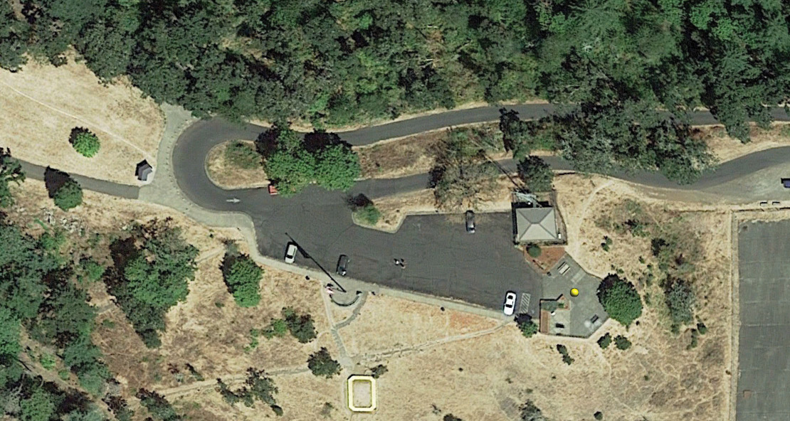
Google Earth
This way became the winding street up to the top of Skinner Butte that still exists today, a large part of it constructed by Doctor Shelton in 1892. The construction of the observatory was given to the low bidder, W. H. Abrams, for a lump sum of $3,275. This was the same contractor who built Villard Hall and Doctor Shelton’s Castle on the Hill. Other expenses came up and the total cost for construction was $4,591.17 including the purchase price of the land. The new observatory was the highlight of the University and the Mathematics Department.

Photo GN27 “University of Oregon observatory behind Shelton-McMurphey house, ca. 1904” Courtesy of the Lane County Historical Museum
Classes in Astronomy and Celestial Mechanics were some of the most popular, but it didn’t take long to realize an observatory so far from campus and in a foggy valley didn’t add up to the original vision. The observatory fell in disrepair and the telescope that was sent to Philadelphia in 1893 for repair and modifications was stolen on the night of June 1, 1897. The telescope was recovered unharmed but never placed back in the observatory. Year after year the once glorious building continued to fall into disorder.
The Statesman Journal 1894.
It was proposed in 1901 to actually move the building to the main campus and use it for historical records in a fireproof setting. This never happened and in 1904 it was ordered to “…dispose of and remove the observatory building…”. The University placed an ad and took bids for the sale of the property and the observatory of which four were received, and all rejected, ranging from $51.75 to $502.50. It was then during the early morning hours of May 12, 1905 that an explosion was heard and shortly thereafter the Astronomical Observatory was fully engulfed with flames. The following morning dynamite was used to finish off the structure and later in the afternoon another blast tore apart any memory of the old structure.
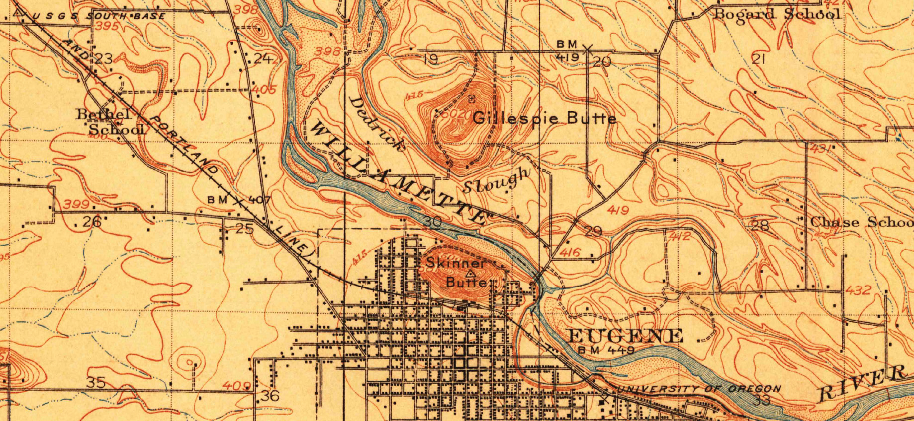
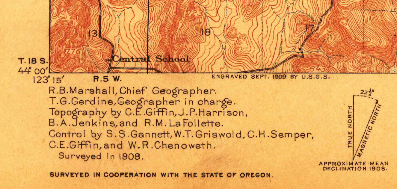
The 1910 Eugene 15’x15’ Quad.
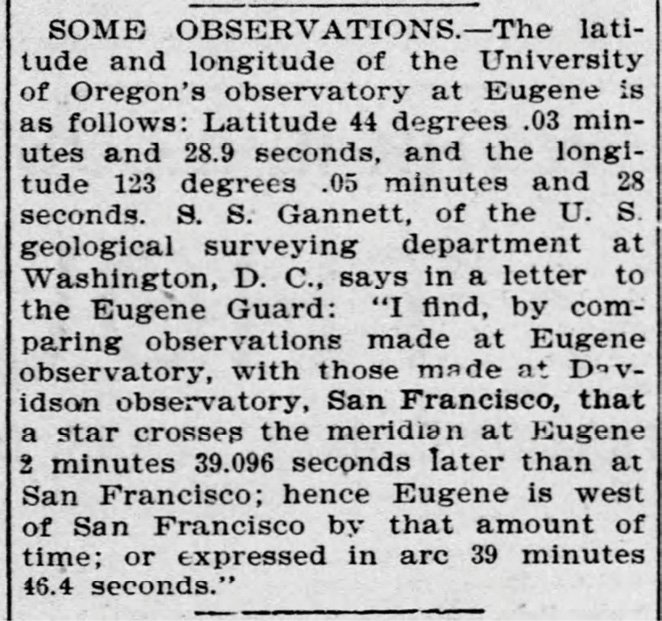
The observatory was so much more than an outdated eyesore though. It served as the basis for all geodetic control work in Southern Oregon and Northern California. In May of 1894, when the observatory was still used on a daily basis, Samuel Stinson Gannett spent countless nights studying and measuring the stars. Gannett spent ten nights alone determining the precise latitude of 34 pairs of stars. As reported to The Eugene Guard on July 6, 1894 the latitude was 44°03’28.9” North.
The determination of longitude was much more complicated though. A wire was literally stretched from the observatory to the Western Union Telegraph Office in Eugene. With the precise readings of a chronometer hooked to the telegraph wire to the San Francisco observatory a time difference could be measured as the same pair of stars crossed the meridian. This measurement was 2 minutes and 39.096 seconds later than San Francisco. The time converted to longitude equated to 39 minutes and 46.4 seconds West of the longitude at the observatory in California. The final longitude was tabulated as 123°05’28” West. This process was repeated for five nights and the final numbers compared.
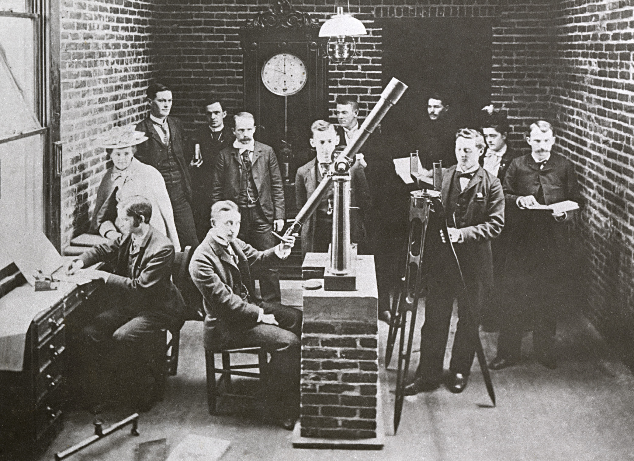
Photo GN6120 “UO class of 1893 inside University of Oregon observatory, 1893” Courtesy of the Lane County Historical Museum
The work of Gannett was one of precision and accuracy. If he would have been off by a mere second (time) in his measurements his longitude would have placed him 1095.31’ West of the actual position. This is based on a distance of 262,886.76 feet for one degree of longitude at the given latitude by Gannett. Geographically this would fall near the old Basalt Quarry, nicknamed “The Columns”, at the Western edge of Skinner Butte. The calculations of a young Gannett can be checked by dividing the time difference by 4 as we know that 360° = 24 hours and 15° = 1 hour and 1° = 4 minutes. His calculations check to within 0.000044 of a second.
This station, along with the accompanying baseline, were the basis for all control in southwestern Oregon. The 38,425.3 foot baseline was measured twice with a 300 foot steel tape by USGS surveyor William Tudor Griswold. This baseline was run along a tangent of the former Oregon and California Railroad from Eugene and through Irving, Oregon. The monument at the observatory was simply listed as a “transit pier”. With knowledge that the observatory was destined to be destroyed the USGS set two marble reference stones to perpetuate the position of the transit pier. They then tied these new monuments into the control network by triangulation measurements.
Samuel Stinson Gannett was at the infancy of his career with the United States Geological Survey (USGS) at this time. At 33 years old he was 12 years into his 52-year career with the USGS. Samuel was born in Augusta, Maine and lived with his uncle and cousin in Bath, Maine while attending Bowdoin College. His cousin was Henry Gannett who would end up being the Chief Geographer of the USGS. Both Sam and Henry would become 2 of the original 33 founders of the National Geographic Society. Sam became known as the “State Line Boundary Retracement Specialist” and was called upon by the Supreme Court to survey multiple disputed State lines.
His most famous would be the 100th Meridian Survey between Texas and Oklahoma, the Deakin’s Line between Maryland and West Virginia and his last survey to demarcate the line between New Hampshire and Vermont. Others include Idaho/Washington, Idaho/Montana, Ohio/Michigan, Wisconsin/Minnesota, Arkansas/Mississippi amongst others. Sam passed away at the age of 77 on August 5, 1939 in Washington D.C. where he lived his whole life.
The Astronomical Observatory at the University of Oregon on the East end of Skinner Butte was at one time the shining star of Eugene. Unfortunately, it also became the eyesore. Its demise is unfortunate but the purpose it served for the control network of the USGS will never be forgotten. The work of Samuel Stinson Gannett and his phenomenal career with the USGS shall be remembered and honored, as shall be the rich history of the observatory itself. This memory shall also include Warren Williams, Eugene Skinner, Doctor Thomas Shelton, The City of Eugene and the entire area of Southwest Oregon. Today, upon a personal visit to the site, nothing exists other than a parking lot on top of the butte and a beautiful view of the valley below, the same view Samuel Stinson Gannett would have marveled upon when he was there in May of 1894.
Note: This article was originally published in the March/April 2019 of The Oregon Surveyor.
Joseph D. Fenicle, MS, PS is a Professor at the University of Akron for its award-winning Surveying/Mapping program. Immediately prior, he was the Chief Surveyor at the Office of the Fulton County Engineer in Wauseon , Ohio for 15 years. He also owns Angular By Nature, LLC, a company specializing in Continuing Education for Surveyors and Engineers across the Nation. Joseph has a MS in Engineering Technology with a Surveying Engineering Technology Concentration from the University of Maine, a BS in Surveying/Mapping from the University of Akron and an AAS in GIS/GPS from Hocking College. He obtained his FAA license in 2019. Joe also climbed Skinner Butte in the rain during the 2019 Annual Conference and stood where Gannett did in 1894 overlooking the City of Eugene.
References
The Call Number. University of Oregon, April 1955
The Old Observatory: University of Oregon. Mitch Stepanovich, December 1977
Sixteenth Annual Report of the United States Geological Survey 1894-95. Charles D. Walcott. Washington DC, 1896.
Eighteenth Annual Report of the United States Geological Survey 1896-1897. Charles D. Walcott. Washington DC, 1897.
Shelton—McMurphey House and Grounds. National Register of Historic Places Inventory—Nomination Form. United States Department of the Interior National Park Service, November 15, 1988.