T3N, R3E, W.M.; Northeast Corner of Section 12, Clark County, WA
One morning after arriving at work, “George” announced that he had been up on the “1410 Road” yesterday and had talked to a local surveyor who was locating the boundaries of a private quarter-section surrounded by state lands. This fellow (I don’t recall his name) had purported to have found the Northeast corner of Section 12. “George” expressed doubt about this since the original corner was a wood post with 4 very small Hemlock BTs (6”, 5”, 7”, 5”), similar in size to the 3 hemlocks called for at the township corner a mile to the north, described previously, and marked by John Trutch that same day. (June 20th of 1857)
He asked if I wanted to go with him to check it out, which I readily agreed to do, not knowing enough to be a bona-fide skeptic yet. We stumbled into the area and walked easterly down an old cat road along the north slope of a bowl-shaped depression. Just below the road was a new ribbon on a small hemlock about 10” diameter. Upon closer inspection, this tree actually had visible scribing on a half-healed face along with two other remaining 1857 BTs. It was incredible that these hemlocks marked by John Trutch were still alive 110 years later, having added only 3 or 4 inches to their original girth.
Their survival against incredible odds was, like Homan’s BT mentioned previously, probably a function of topography. The corner was in a gentle swale with a higher, rolling ridge running northerly several hundred feet to the east, protecting the corner area from the east wind that was pushing the fire westward on that stifling hot September day in 1902. The humidity was reportedly near the vanishing point, yet the heat of the fire was diverted slightly upward and past the ridge to the east and the lower dog-hair stand of hemlock in the swale. That timber was so thick, I could hardly squeeze between the trees on that October morning in 1967.
T4N, R3E, W.M.; Northeast Corner of Section 25, Clark County, WA and the NW corner of Section 30, T4N, R4E.
In 1972, I left the Washington Dept. of Natural Resources and commenced working for Hagedorn Land Surveying, a very small company that later became Hagedorn, Inc., from which I retired in December of 2009. During almost 38 years of private practice, I was involved in many different aspects of the survey profession, but always gravitated towards retracement oriented jobs when possible. In 1973, I was tasked with subdividing Section 30, T4N, R4E, which lies in the Dole Valley area of Clark County and also within the infamous Yacolt Burn footprint. The west line of Section 30 runs north across the steep eastern slopes of a large “mesa” called Bell Mountain. Settlers had not started homesteading this area until the early 1880s. Consequently, their clearings in the forest and lackadaisical view of fires, left smoldering all summer and considered a sign of “progress” at the time, would eventually lead to the series of fires and reburns that would plague the valley for the next 70 years. Consider the following timeline of events in and around Section 30:
John Trutch surveyed the east line of T4N, R3E and established the NE corner of Section 25 on June 24, 1857, only 4 days after setting the township corner, discussed earlier. He set a wood post, appropriately marked, referenced by 3 vine maple s and a 40” fir BT.
31 years later, a Vancouver newspaper article dated September 17, 1888 reports “A terrific forest fire swept toward Yacolt Prairie on the wings of a strong east wind: When discovered, the fire was coming down the Rock Creek country through the old burn. Huge stubs were falling in all directions and soon Bell Mountain was a roaring mass of flames.”
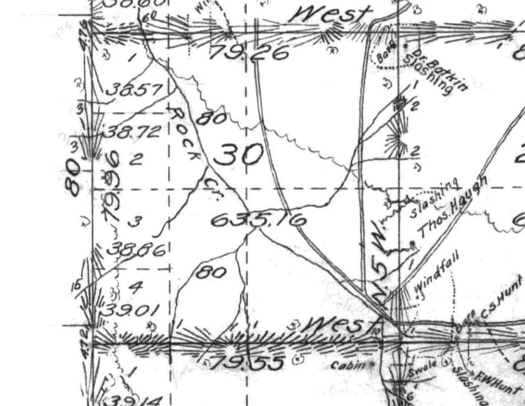
Figure 3: GLO plat showing a portion of T4N R4E surveyed in 1897-1899.
In 1897 and 1898, Charles Homan, Deputy Surveyor mentioned earlier, (see NE corner of Section 35, in Part 1), subdivided T4N, R4E and ran a true line West from the NE corner of Section 30 and intersected Trutch’s 1857 range line about 314 feet south of Trutch’s NE corner of Section 25. (see Figure 3 and Figure 4) On June 23, 1898, Homan sets a wood post for the closing corner and marked two BTs as follows:
“A fir stub 60 ins diam brs N 12° 45’ E 130 links dist marked T4N R4E S19 BT” and
“A fir stub 50 ins diam brs S 12° 30’ E 114 links dist marked T4N R4E S30 BT”
In the notes establishing the closing corner for Sections 30 and 31, Homan also states “The old corner of sections 19, 24, 25, and 30, which was a post has been destroyed by fire and the witness trees have been burned down, but the stumps of the trees, described as bearing trees still remain and correspond with the bearings and distances given in the field notes of survey of East boundary of Township 4N R3E. I reestablish this corner at same point as follows: “Set a fir post 3 feet long 4”square…marked…from which
A dead fir 40” diam brs S 13° 30’ W 155 links dist marked T4N R3E S 25 BT” and
“A dead fir 40” diam brs N 55° W 91 links dist marked T4N R3E S 24 BT”
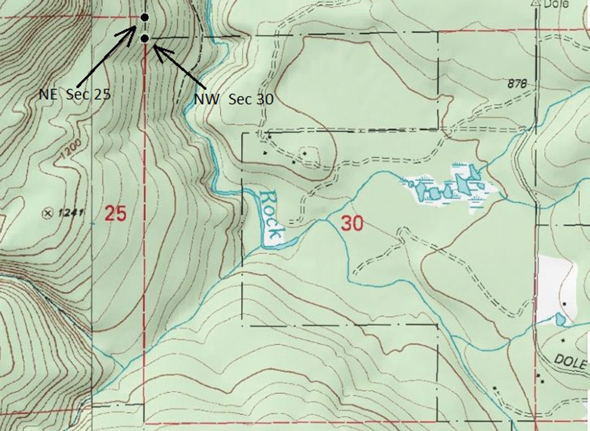
Figure 4: Topography around Section 30, T4N R4E, Clark County, WA
It would only be 4 years later that the Yacolt Burn of 1902 would leave its everlasting mark on the land and the memories of those who witnessed it. Estimates of lives lost range from 38 to 57. The “parade of fires” after 1902 are noted in the following newspaper stories:
In August of 1910, a forest fire raged about 2 miles southeast of Yacolt. One fire started in Dole Valley and raced up over Bell Mountain to be met later by a series of fires that a log-train locomotive of the Northern Pacific Railroad had set.
On July 2, 1922, the Vancouver newspaper reported “For the fifth time, a re-burn has been re-kindled in the 1902 Yacolt Burn. The fire destroyed 5760 acres of re-growth”.
September 6, 1929; “The largest fire since the 1902 burn has blackened 227,520 acres in Clark and Skamania counties. The fire lasted for a month and extended to points near Amboy, Yacolt, Venersborg, Skamania, and Stevenson. The fire burned in a small way in the Dole region for two weeks or more prior to its report on September 6. Many separate blazes were involved, and they gradually merged as they swept over the area.
At that time, Pete Paladeni, local resident and mentor of mine when I first came to the Honor Camp and later, a good client and friend, was a lad of 16. He related the terror of that evening in mid-September to me. His father, Mike Paladeni and his wife and children had lived on their farm in the north half of Section 19, just north of Section 30, since the early 1920s. With the help of the whole family plus some men from Yacolt, they managed to save the house and barn, which was their only livelihood, and they still stand today!
After the 1929 fire, more newspaper articles report other local fires:
1946: On May 2, “Fire broke out in the Dole area at about 5 a.m. and raced westward across Bell Mountain in an approximate 3 mile wide swath in May.”
1949; “In April, fire on the west side of Bell’s Mountain burned more than a thousand acres of brush, snags, and replants”
As I ascended that 70% slope on the west side of Rock Creek by myself in the late spring of 1973, I couldn’t help but wonder if any evidence of either Trutch’s or Homan’s corners would remain after such a parade of destruction had ravaged that steep east slope of Bell Mountain over the preceding 115 years. I had found that when looking for BTs, it helps to calculate the bearings and distances between them beforehand. When you finally get in the “probable corner area”, one locates a snag, stump, or uproot of the appropriate species and size and then sets the bearing to the other BT, as previously calculated, in a compass. In this case, there were only 2 BTs for the NW corner of Section 30. The resultant bearing and distance, tree to tree, is N 1 ½° E, 157 ft. It is notable that Homan calls each of these BTs “a fir stub” and at Trutch’s corner 4.76 chains (314 ft) to the north, he marks 2 new BTs for the corner of Sections 24 and 25, each of which he calls a “dead fir”. To me that suggests that the “dead firs” were still snags, possibly from the fire in 1888, while the “fir stubs” were the remains of trees killed in a much earlier fire.
At any rate, that steep hillside was now covered with thick vine maple brush and 20 year old fir reprod, which took a lot of brushing to subdue. After trying about 3 combinations, I finally found 2 big “fir stubs” that were at the appropriate distance and bearing apart. I then “backed off” from the south BT to the closing corner position and checked the record to the north BT which fit with a foot. I then chained north 314 ft and tied a ribbon for the temporary location of Trutch’s 1857 corner post. Brushing out to the NW, I found a snag of about the right size, so I measured back S 55° E, record distance and adjusted my earlier “corner ribbon” by about 3 feet. Then I started to brush out an “alley” towards the SW BT. As I neared it, I could see the top 30 feet of a 40 ft high snag ahead on my line.
As I cut away the remaining “vineys” that had been right against it, I was flabbergasted to see partial scribing on a weathered, worm eaten-face. I measured the distance back to the corner ribbon, adjusted it again, using the intersection of both BT distances, and stuck a temporary spike in the ground for the corner. I never expected to find original 1898 scribing, given the fire history, but also knew it wasn’t going to last much longer. The fragile slab was about ready to fall off so I took it into “protective custody” where it still remains, safe in my basement. (See Figure 5)
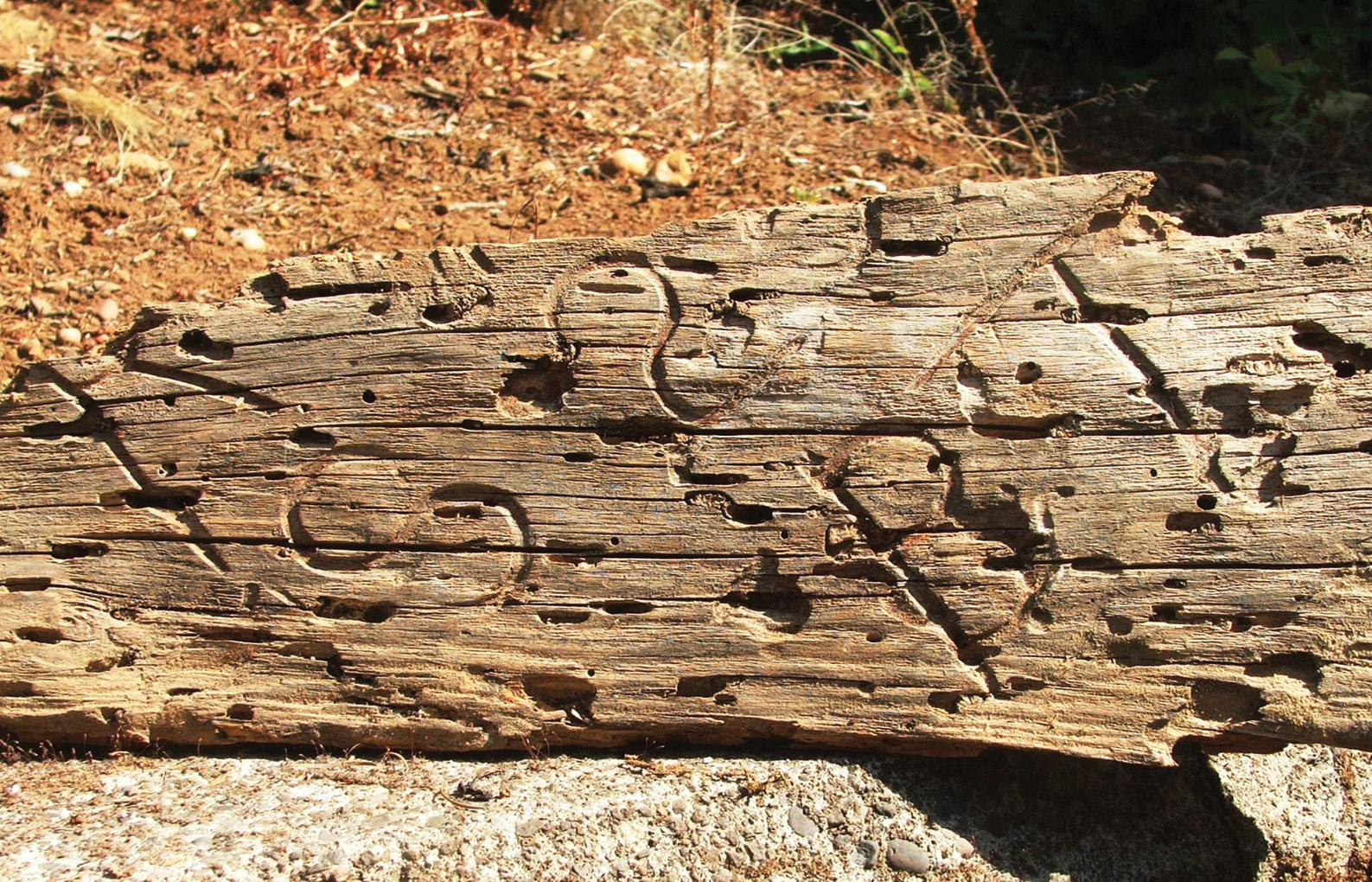
Figure 5: The “slab” from the 1898 BT. (partially showing “R3 S25 BT”)
In hindsight, it is probable that earlier fires killed the big firs; first in about 1860 (resulting in “fir stubs”) and in 1888 (resulting in the “dead firs”). Given that, the BIG fire of 1902 didn’t have a lot of heavy fuel left on this particular hillside and probably ran up the hill quickly, mainly consuming brush and luckily didn’t destroy the scribed BT found in 1973.
T4N, R4E, W.M.; Northeast Corner of Section 22, Clark County, WA
This corner was established by Charles Homan on June 20, 1898, who set a wood post with 3 green fir BTs (30”, 40”, and 50”diameter) and a dead 20” fir stub. In 1899, Homan replaced the wood post with a stone (like he did at the Northeast corner of Section 35 described earlier) as per Special Instructions dated August 16, 1899. Homan described the stone as “a trap rock 12x10x6 ins., 8 ins in the ground…marked with 3 notches on S. and 2 notches on E. edges”.
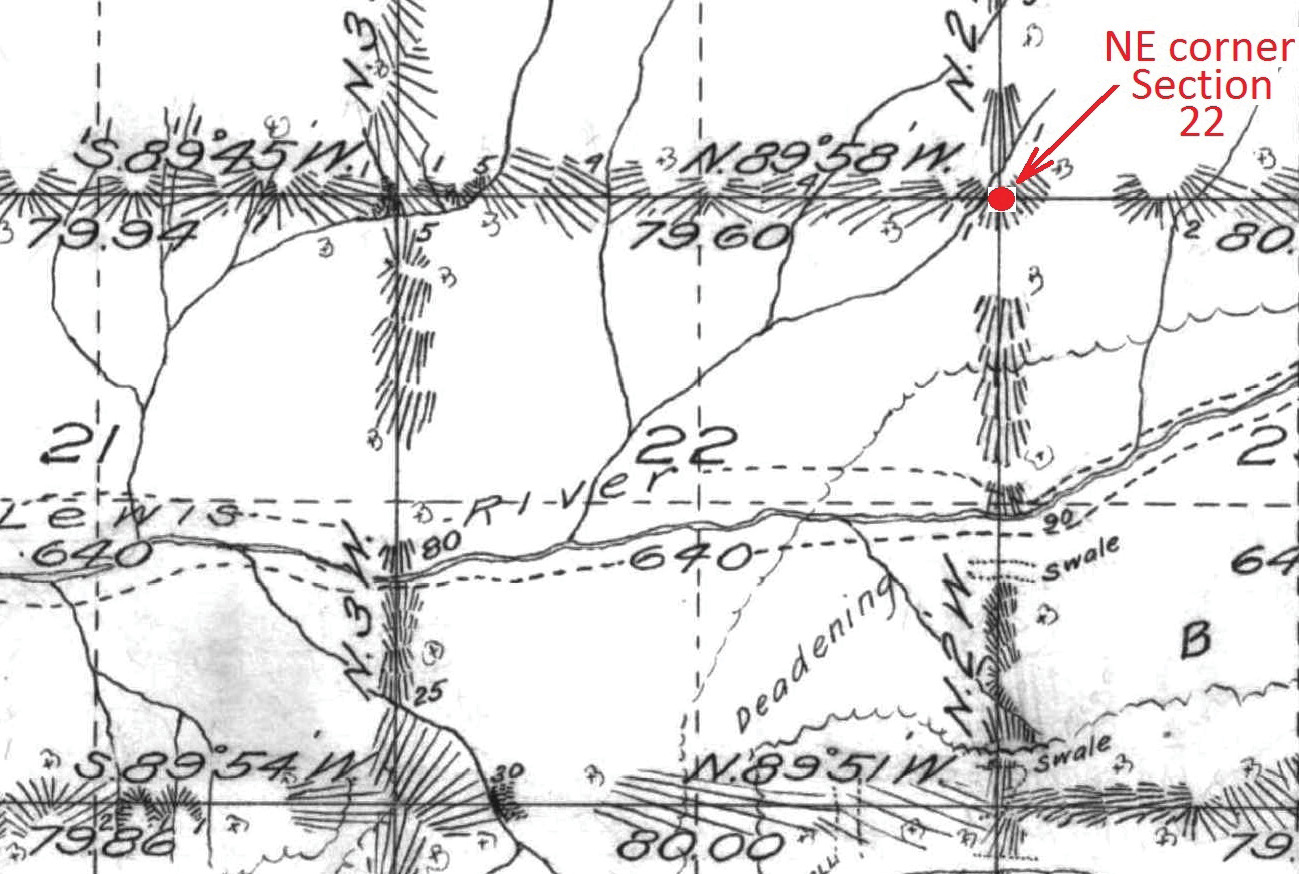
Figure 6: Section 22, T4N R4E, Clark County, WA.
In August of 1991, I was tasked with locating cutting lines for a local timber company within Section 22. While researching the Clark County Surveyor’s records, in addition to Deako’s work noted above, I saw that a Vancouver surveyor had subdivided Section 22 in 1975 and noted finding 3 BTs at the NE corner thereof. He then filed a “record of survey” showing his measurements, etc. I decided to take a look at the NE corner of Section 22 in the field to satisfy myself in regard to the “1975 original evidence” since no stone was reportedly found. What the 1975 surveyor called “BT stubs” were exactly that, being short, badly rotted old firs, but loosely fitting Homan’s 1898 bearing and distance calls to his 1898 BTs.
However, three things troubled me about the 1975 survey. First, in between the pipe he set and two of his “BT stubs”, there were burnt snags, 30 to 50 inches in diameter that were obviously much younger than his “BTs” (Firs of that size usually will be from 200 to 400 years old) and Homan would have had to measure through them to get to the alleged 1975 “BT stubs” which appeared to be remnants of a previous timber stand! I surmised that they were probably already dead and decayed in 1898 when Homan was there, prior to the Yacolt Burn.
Second, the 1975 corner position was on a slight west slope and a corner stone wouldn’t have been susceptible to “soil creep” and/or rolling downhill to the west as it would on a 40% to 80% slope. It should have been there but wasn’t. Third, Homan’s 1898 notes running west from the corner read “N 89° 58’ W on a true line bet Sections 15 and 22, descending from corner through heavy green timber and dense underbrush, 1.31 chains (86 feet), Branch 1 link wide course south”. From the 1975 corner, the creek is only 50 feet to the west. Given those “issues”, I felt the corner was probably further east and made several visits over a two week span trying to find a pattern of snags that matched Homan’s “geometry”.
After many frustrating searches I finally found the original stone quite by accident. I had visited the section corner one mile north and noted the character of Homan’s stone and its notches. Back at the NE corner of Section 22, since I couldn’t come up with any BTs patterns, I started looking for a stone that fit the dimensions called for, since the stone at the NE corner of Section 15 (dimension wise)was accurately described by Homan. My survey crew and I must have rolled fifty rocks over to no avail. I happened to be going back over one of them since it was about the right size but had no marks. Within about 6 feet of it I noticed a piece of a chocolate-colored rock about the size of a coffee cup. I was about to discard it when I noticed that it had 3 distinct notches on one edge and two on the other!
I started looking for another chocolate colored rock that might match the jagged fracture line on the notched chunk. Within a foot, I found the matching piece that fit perfectly, but I could then see that these two pieces had broken from a larger rock which I theorized might still be in place and should also be very close by. In a minute or so, after some probing and digging, I found the “mother rock” firmly in place, partially obscured by the roots of a big hazel clump and 90 years worth of duff.. After several combinations, the two “pieces” fit perfectly on the top of the undisturbed “mother rock”, leaving only a wedge-shaped void 1”x2”x3”.
That last missing piece was found under several inches of “duff” on the south side of the in-place rock. (See Figure 7)
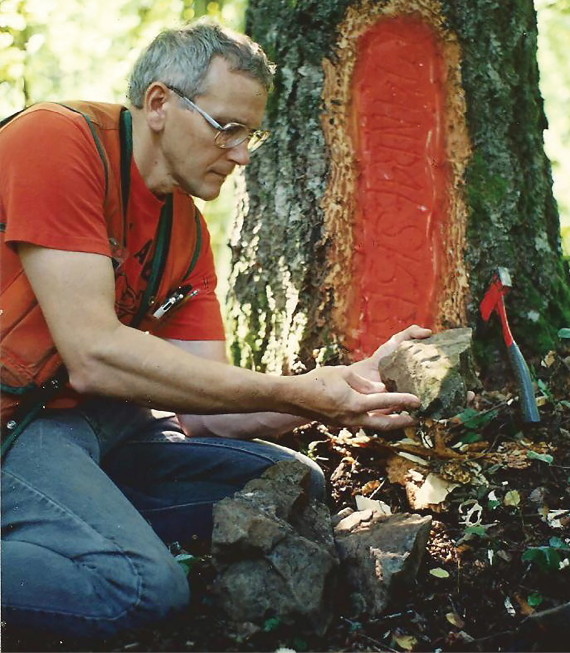
Figure 7: The first piece found of the “chocolate colored rock”
Now, from Homan’s actual corner stone, I tied the centers of 3 adjacent burnt fir snags to see if any could be reconciled with Homan’s 1898 notes.
There were no old snags at all in the Northeast quadrant or the Southeast quadrant.
A 50” fir snag was found S 00° E, 45.3 ft. (record was S 3° W, 46.9 ft.)
A 40” fir snag was found S 55° W, 16.1 ft. (record was S 55° E, 16.5 ft.)(see figure 8)
The only other potential BT was a 40” fir snag, N 25 W, 36.3 ft. which did not fit any of Homan’s “calls”. I believe that the two snags to the south and southwest are the only BTs remaining from 1898. (see Figure 9) The creek “called” at 86 feet to the west in Homan’s notes was within about 10 feet of that record distance.
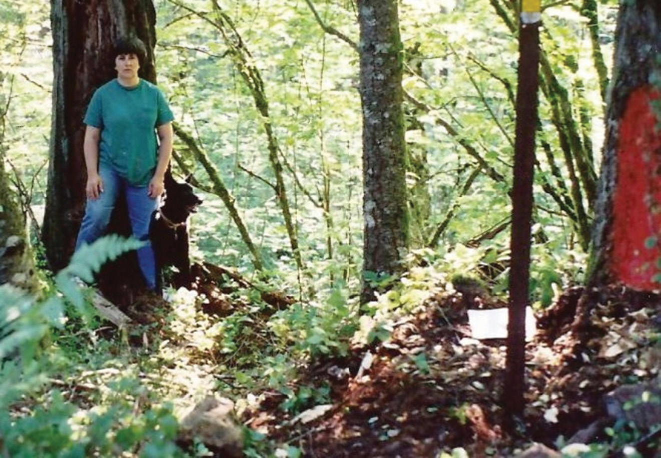
Figure 8: My wife Sharon & “Cinder Bear” by the BT, S 55° W, 16’. Original Stone at lower right.
The 1975 surveyor’s iron pipe was found to be 27 feet west and 1 foot north of the actual corner position. (I guess that might also qualify as a “gotcha”) It is somewhat ironic and amusing that the 1975 surveyor unknowingly mistook the actual “SW BT” to be his “SE BT”, being one of his “3 BT stubs” but the only one that wasn’t badly rotted. (See Figure 8 and Figure 9)
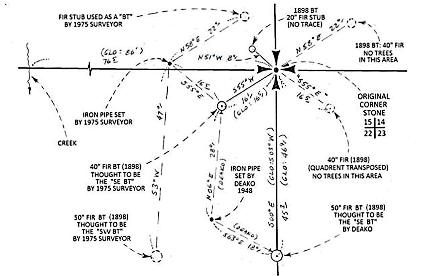
Figure 9: Sketch of corner area.
In September, 1948, Clark County Engineer Charles Deako conducted a survey which shows the East line of Section 22. He monumented the East quarter corner and the Northeast corner of Section 22 with 1” iron pipes. Those two corners were each set from what he notes as an “original tree”. His map shows the resultant north half mile being North, 2610.2 ft. The 1948 pipe set by Deako for the section corner was found to actually be 36 feet south and 13 feet west of the actual corner stone as recovered in 1991.
It is ironic that the two 8” spikes he used to reference his 1948 pipe were actually driven into the backside of the only 2 BTs remaining from Homan’s 1898 survey. Deako obviously applied the S 55° E, 16.5 ft GLO call to what I now know to be Homan’s “S 3° W BT”. For unknown reasons Deaco set his pipe 18 ft. away from it instead of “16.5 ft.” and used the bearing of S 63° E instead of Homan’s “S 55° E. (see Figure 9) The above tangled web of activity illustrates how dangerous it is to make assumptions that occasionally come back to haunt someone who “assumes”. We’ve all heard the old adage connected with that….!
Note: This article was the 2019 Article of the Year in the Oregon Surveyor, and is reprinted here with permission of PLSO and the author.
C.E.“Chuck” Whitten graduated from Santiam High School in Mill City, OR in 1963. He then went to Oregon State University and graduated in Forest Engineering in 1967 and then was hired by the Washington Department of Natural Resources from 1967 to 1972, working on road location and surveying for timber sales. From 1972 until retirement in 2009, he was a project manager and vice-president for Hagedorn, Inc., a private surveying/engineering firm in Vancouver, WA. Since then, he has enjoyed retracing original GLO surveys. In June, 2021 he was hired by the Marion County Surveyor in Salem, OR to recover section corner evidence in 6 townships devastated by the Beachie Creek and Lionshead Forest Fires of 2020.