PART I
Most “older” surveyors have had the opportunity to search for corners set by the Deputy Surveyors hired by the General Land Office (the “GLO”) in the execution of the Rectangular System. This treatise is intended for the “younger surveyors” in our profession who may not have had the opportunity to delve into the nuances of these “original surveys” that are the foundation of almost everything we do, in some way or another.
In Oregon and Washington, the first corners were established beginning in 1853 with the survey and monumentation of the Willamette Meridian and Base Line. Subsequent surveys of township boundaries and subdivision of those six-mile square blocks into sections followed soon after and were generally completed for the lands most suited for habitation and cultivation in Oregon and Washington (previously part of the “Oregon Territory”) by about 1900.
The monuments and marks that represented these corners took many forms. Early monuments were usually wood posts with appropriate numbers and letters carved into them with a “marking iron” (also called a “scribe”) to represent a unique point in the rectangular survey system. Later instructions to surveyors (beginning in about 1890) called for stones to be set for monuments with either notches or letters and/or numbers chiseled into them when practical. Those rocks were obviously much more durable than a wood post which was susceptible to destruction by fire or natural decay.
With the end of the “contract survey system” and the advent of the “direct method” in about 1910, government employees now made up the field survey crews instead of Deputy Surveyors (who were actually independent contractors). From then on, the monuments set were usually iron pipes with brass caps. Regardless, the retracement of those “Original Surveys” and recovery of either the monuments set in them or the accessories established as a reference in case the actual corner points were lost or obliterated, has become a noble “game” for those surveyors (and other zealots) who desire to play it. Those corners set so many years ago are still the foundation upon which most all property boundaries depend on.
For me, this pursuit started in the summer of 1964 while working for the U.S. Forest Service in the Detroit, Oregon area where I grew up. Occasionally, a helper and I would be handed the notes for a particular section corner and told to go look for it and tie it in to the p-line or timber sale unit boundary for mapping purposes. Without any real “training” in this task, we would stumble around like blind men. We may have been “sighted” but unfortunately, had no idea of what to really “look” for which would explain why we always “drew a blank”. After almost 50 years of playing the “game”, I have developed a pretty good idea of what to look for now. Sometimes, the traces of those old corners and bearing trees are very subtle, as anyone who has been similarly perplexed and/or exasperated can attest. Some of my more memorable instances of successful retracement and recovery are recounted here.
T3N, R3E, W.M.; Northeast corner of the Township, Clark County, WA:
(W.M. being “Willamette Meridian”)
This township is located in a vast area locally known as the “Yacolt Burn”, site of a major forest fire in southwest Washington that took place in 1902. It destroyed two hundred and forty thousand acres, containing 12 billion board feet of fine old growth timber. That forest fire was the largest ever in the State of Washington up until the summer of 2016, when one on the eastside of the state surpassed it!
The GLO surveys had already been done in a majority of the area burned in 1902. Most of the corner points were marked with wood posts in the 1850’s through 1890’s with many others being marked stones set in the latter 1890s and afterwards. The 1902 conflagration consumed most of the posts and a great many of the accompanying bearing trees. The township corner in question was originally established on June 20, 1857 by a U.S. Deputy Surveyor named John Trutch. He set a wood post and also marked 4 bearing trees to witness it. The bearing trees were 3 small hemlocks, 6 to 10 inches in diameter, and a 72 inch fir.
I had first arrived on the scene in June of 1967 as a recent graduate of Oregon State University and newly hired by the Washington Department of Natural Resources as a Forest Engineer and assigned to the Larch Mountain Honor Camp. (See Figure 1) This camp had been first established in the late 1950’s to utilize prison inmates in an effort to rehabilitate a large portion of the Yacolt Burn that had fallen into state ownership. The inmates were organized into different crews and directed by state employees to fall snags (remaining from the 1902 and later re-burns), build fire roads and main access roads, plant trees, and fight fires among other things. Superintendant Elwin Dooley had assigned me two inmates to be my survey crew.
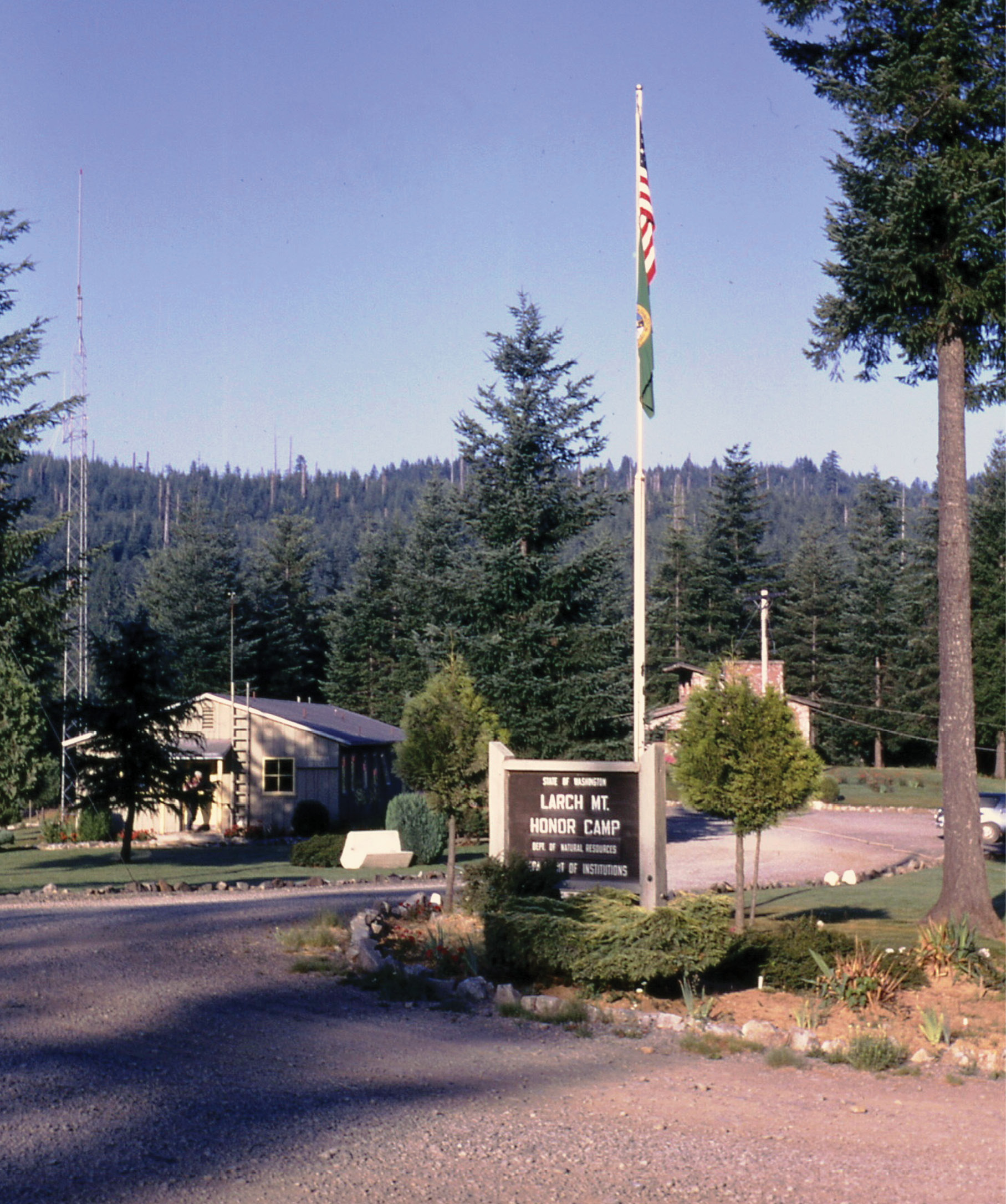
Figure 1: DNR Office at the Larch Mountain Honor Camp in 1967.
One was an architect and the other was an attorney and both of them were reportedly “in on a bum rap” (as were the most of the rest of the inmates).
My job was to locate new access roads and direct their construction and recover and monument section corners. (the latter task I still had not had much experience with up to that time) There was however, a forester at the camp (who I’ll call George in lieu of his real name) that had worked there for about 6 or 7 years. He professed to be “a corner finder from way back” and proceeded to fill me in on his exploits in that regard every chance he got. His modus operandi was to locate the corner locus by scaling creek or ridge calls from the GLO notes on a “stereo pair” of aerial photos. Then he would go to the spot, photos in hand, and search. There was no question he had found some original corners in “the burn”, and had developed a sense of “what to look for” as a result.
Unfortunately, he, like many other “corner prospectors”, including myself in those early days, would get caught up sometimes in using imagination instead of hard evidence to justify a corner location. It takes a while to settle down and quit speculating on what the original surveyor did and concentrate on the hard evidence available. Occasionally, when the wood post is long gone and the marks are burned off the trees, you can conclusively locate the original corner position by finding a “stump pattern”. This can be a pattern of usually two to four trees (based on the original bearings and distances to the BT’s from the original corner) the reliability of which is greatly enhanced if the trees are of different sizes and species. Anyway, “George” came back to the Honor Camp one afternoon and announced in his booming, deep voice that he had finally found the Northeast corner of Township 3 North, Range 3 East up by Spotted Deer Mountain. He proclaimed that he found Trutch’s 72” fir BT and the roots of the three hemlocks which he identified as being hemlock by using a magnifying glass.
Several years and many corners later, I was doing a survey that required this township corner for control. I went to the area and located George’s “high-pole” set several years before. I immediately noticed that there were two 72” fir snags, one about 40 feet east of the other, neither with any marks remaining. (“George” had used the west one) I was curious about the hemlocks and ran out the bearing and distance to each from both possible corner points, but found nothing in the “pasture” of 4-foot high salal, ferns, blackberries, and big fallen snags.
Back at the DNR office, I happened to notice that the surveyor for the adjoining township (Robert Webster in T3N, R4E) had run a random line west for six miles in 1896 and noted the falling at “Trutch’s township corner”. To my surprise, Webster had also noted Trutch’s 1856 BT’s along with a little note that said two of the hemlocks had been destroyed by fire and that he added two new trees in their place. One was a 4” vine maple, but the other was a 36” fir bearing N 39° W, about 24.5 feet. Armed with this new information, I went back to the area several days later the new notes in hand. There was no sign of a big tree NW of George’s “hi-pole”. I then “backed off” the record bearing and distance from the eastern 72” snag and hung a ribbon at the potential corner location. Measuring N 39° W, 24 feet, I found a 36” fir stub hiding in a big vine maple clump. No marks were visible, but it looked suspicious, so I made a few chops with my Hudson’s Bay axe where the face would have been and, behold, a slab fell off revealing Webster’s scribing in all its glory. It was the first “gotcha” I ever made.
It would probably be safe to say that more than one surveyor has tended to form a preliminary conclusion about the probability of finding corner evidence after reading the notes and learning the character of trees used for accessories. This is especially true in an area like the Yacolt Burn, where the hurricane of fire was so hot that puny marks on wooden posts and trees usually didn’t have much chance of surviving. The intensity of such a conflagration is hard for one to imagine today, but accounts of such calamitous fires shed much light on them.
Stewart Holbrook, in his classic book “Burning an Empire”, recounts the ferociousness and finality of the flames after talking with a survivor of the great fire that swept through the white pine forests around Peshtigo, Wisconsin in 1871. “Now the sawmill, by the east end of the bridge, began burning like a vast furnace. The logs in the mill pond began to smoke, then to light up with flame. John Cameron and many others were fleeing down the east bank of the river. On the way they saw things they never forgot. They saw horses and cattle, yes and men and women, stagger a brief moment over the smoking sawdust streets, then go down to burn brightly like so many flares of pitch-pine. Charles Lamp had loaded his wife and children into a wagon and started. One horse was struck down by a falling tree. Lamp got out to help the horse up. Just then, the fire swept the wagon, and the family died where they sat. Lamp ran to a nearby brook and got into the water. Two hours later, when the worst of the fire had passed, he returned to where the team and wagon had been. Everything had been consumed.”
About the “Yacolt Burn”, Holbrook writes “W.E. Newhouse, the star route mailman, was at home when he saw what was to be the end of things for him coming down the mountain. He hitched his two fine horses into his mail buggy, and away they went. When Joe Polly and a searching party came in a week later, they found one horse on top of a huge felled log, high off the ground, close beside the trail, the last mighty leap of an animal in terror. The other horse had made it to a small opening, and no more. But they looked for days before they found the mailman. He had hidden in a small gully. They found him, his clothes and skin burned away, reclining against a log, a short piece of steel rod held firmly in his hand. It was the inside part of his buggy whip, with the rattan burned off”.
About 9 miles north of the present Honor Camp he writes ”the fire tore down the hill and paint began to blister on the fifteen buildings that comprised Yacolt. Some of the elder folks looked at the terrifying spectacle and said it was the end of the world, sure enough. The entire population went to a nearby creek and stayed there all night. Next morning they found Yacolt blistered here and there, but intact. The main fire had stopped less than a half mile from the settlement and had been hot enough to make paint run from that distance.” Holbrook continues “No man who has stumbled through the thick warm ashes and over the blackened windfalls in the wake of a devastating forest fire has failed to be struck by the scene. It is unforgettable. The stark silhouettes of trees, the stumps like sable tombstones, the acres as far as the eye can reach all barren and smoking.” (See Figure 2)
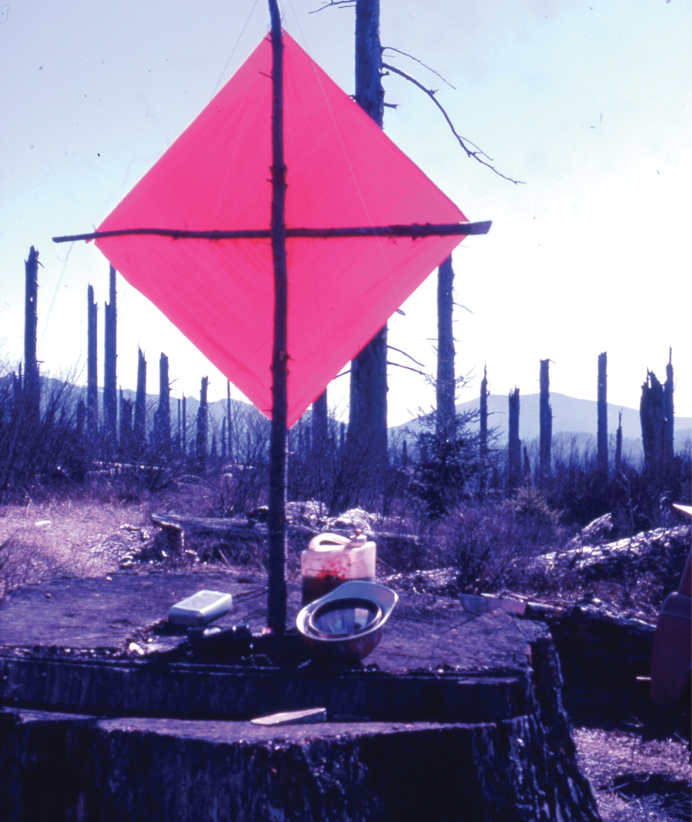
Figure 2: 1969; View looking southeasterly from the “mesa” on top of Bell Mountain, 9 ½ miles to the next traverse point at Pyramid Rock (on the skyline left of the target pole). A 6 foot diameter stump makes a very stable platform to occupy with a tripod and instruments (or target in this case).
With those scenes in mind, consider the prospects of finding wooden survey evidence remaining in such an area. It is hard to get too optimistic about finding corners or accessories after they have been subjected to the blow-torch effect of major fires like those mentioned above. Yet, through quirks of nature, it has still survived in isolated situations. Some of those in the Yacolt Burn are recounted here.
T4N, R4E, W.M.; Northeast Corner of Section 35, Clark County, WA
U.S. Deputy Surveyor C.A. Homan was awarded Contract 415 to subdivide Township 4 North, Range 4 East, W.M. in 1897. Special instructions were added in 1899 by the GLO (after all the corners had been initially set) to replace the wood posts with marked stones wherever possible. “George,” mentioned earlier, had found a section corner in the southeast quarter of the township. He recovered a couple BT snags and found the original marked stone. That particular area was one that had small openings (maybe 100 feet in diameter) of solid slab rock here and there that not even weeds could grow there. One such opening happened to be next to the corner in question.
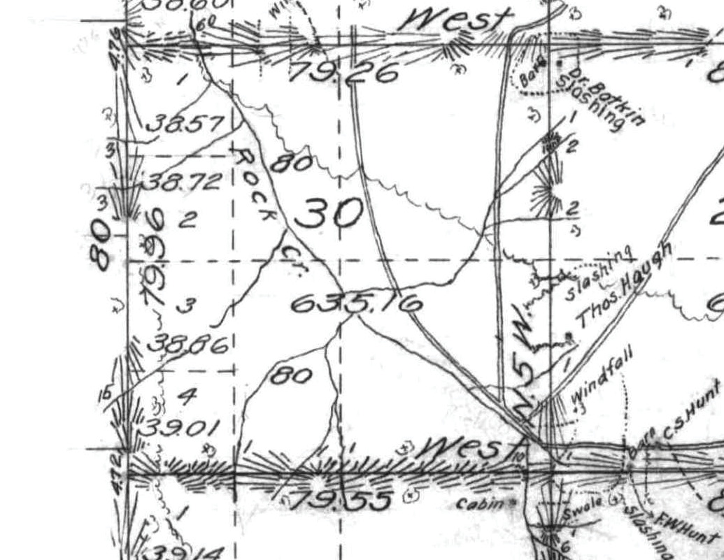
Figure 3: GLO plat showing a portion of T4N R4E surveyed in 1897-1899.
While walking through it, George noticed a wood post on the ground. Upon closer inspection, it turned out to be the original wood post set in 1897 that had been removed and thrown away after replacing it with the stone. Through a quirk of topography, the winds bearing the firestorm either lifted up a bit right there or a whirlwind siphoned the heat away. Whatever the cause, it allowed the post to remain intact, right where Homan had tossed it, the scribing still distinct and only slightly charred and case-hardened for the next 70 years. George had brought it back to the office and showed everyone, me included. It was indeed a rare find and I regret to report that he later gave it to an inmate (go figure) and that inmate and the post have long since disappeared. If I had been more alert, I would have taken it into “protective custody”.
A brilliant and enlightening biography of C.A. Homan appears in Jerry Olson’s website; go to northwestglosurveyors.com; then click on “General Land Office Surveyors of Washington”; and then scroll down and click on “Personal Data written by Jerry Olson on the Washington GLO Surveyors”; on the left side is an alphabetical listing of the surveyors. It is a voluminous compilation of all the deputy surveyors who had contracts in Washington, preceded by a synopsis of the development of the GLO in the Oregon Territory, starting in 1851.)
Note: This article was the 2019 Article of the Year in the Oregon Surveyor, and is reprinted here with permission of PLSO and the author.
C.E.“Chuck” Whitten graduated from Santiam High School in Mill City, OR in 1963. He then went to Oregon State University and graduated in Forest Engineering in 1967 and then was hired by the Washington Department of Natural Resources from 1967 to 1972, working on road location and surveying for timber sales. From 1972 until retirement in 2009, he was a project manager and vice-president for Hagedorn, Inc., a private surveying/engineering firm in Vancouver, WA. Since then, he has enjoyed retracing original GLO surveys. In June, 2021 he was hired by the Marion County Surveyor in Salem, OR to recover section corner evidence in 6 townships devastated by the Beachie Creek and Lionshead Forest Fires of 2020.