In October of 2021 there were four hunters who travelled down Rattlesnake Pass Road in Carbon County, Wyoming. They stopped their truck, checked their OnX App to verify their position, and hiked a short distance across land owned by the Federal Government. They immediately saw the protruding 2 ½” Post marking the Section Corner and discussed the two steel posts, chained together, with signs affirming, “No Trespassing”. This is the Southwest corner of Section 13, Township 20 North, Range 82 West of the 6th Principal Meridian. The hunters looked at each other and knew exactly what they had to do. They set up their custom-built ladder, resembling one you would use for an above ground pool and technically a stride, and climbed up and over the fence posts, being careful not to touch anything.
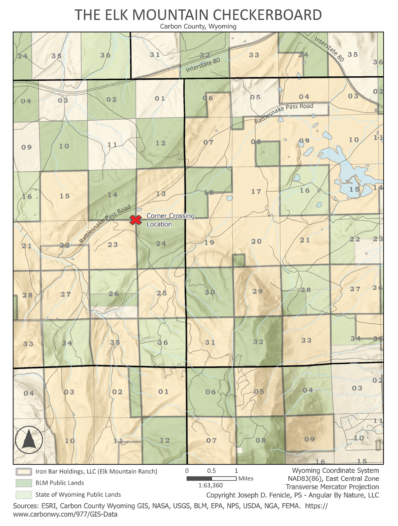
They could have easily walked around the posts, as they were the only things around, but doing so would have led to a clear trespass. What these folks did was corner cross, and they did so from one piece of Federal Land to another and it has been going on for decades. Up until recently no one made much of a fuss. That was until they corner crossed onto Elk Mountain Ranch and were arrested by the local sheriff for criminal trespassing. A jury later deliberated for less than two hours and reached a non-guilty verdict.

However, the four men are now facing a civil trespassing lawsuit, that could exceed 7 million dollars, for property damage due to the diminishing value of the Ranch. This lawsuit has escalated to the U.S. District Court in which the verdict could set precedent across the nation on the accessibility of the approximately 9.52 million acres of Federal Land that are currently landlocked and inaccessible without maneuvers like corner crossing. The real issue here is airspace and whether corner crossing constitutes a trespass by passing over the airspace of a private parcel to gain access to a public one.
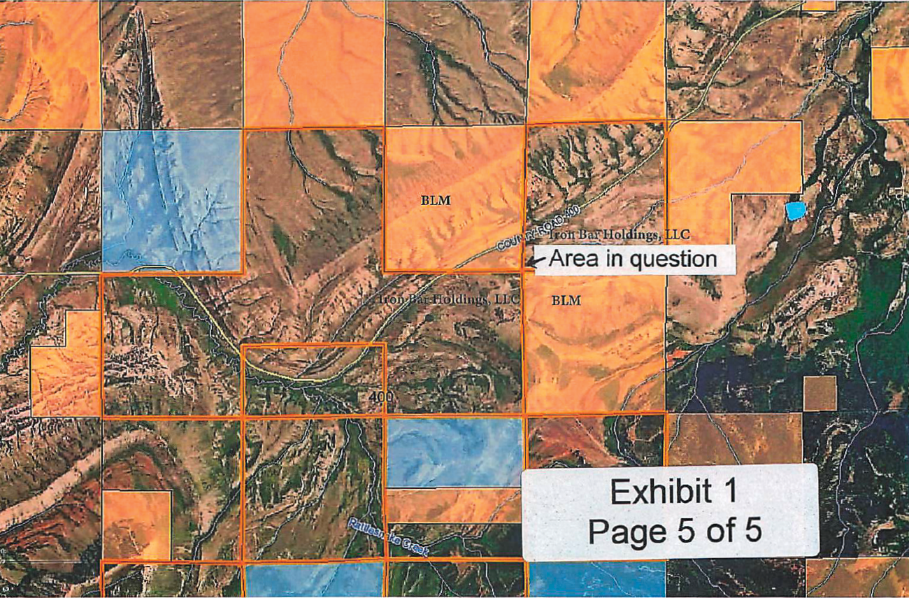
Exhibit 1 from the Carbon County, Wyoming Court Files. Courtesy of WyoFile Reporter Angus Thuermer.
The Section Corner the gentlemen stepped over was originally set by General Land Office (GLO) Deputy Surveyor (DS) Lewis Lampton in 1878. The corner was then part of a Dependent Resurvey by GLO DS Wayne Gardner in 1967. It was at this time that DS Gardner found the original monument set by Lampton and replaced it with the Post. In the original field notes from 1967, Gardner States “…are monumented with the Bureau of Land Management’s standard iron post cadastral survey monument, consisting of an inscribed die cast brass cap, permanently mounted on a galvanized iron pipe, 29 ins. Long, 2 1/2 ins. diameter”. During the Dependent Resurvey, Gardner found “…a sandstone, 14x8x3 ins., illegibly mkd., loosely set 3 ins. in the ground”. This was the corner set by Lampton and currently buried alongside the new post.
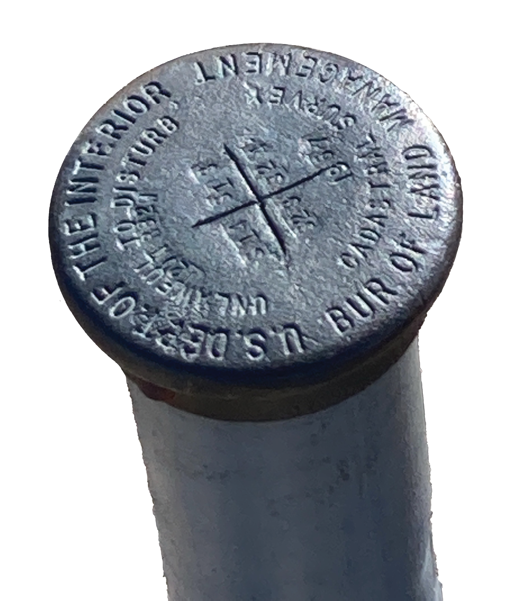
Physical location of the Corner Cross shown on cover with BLM Section Corner Monument. Courtesy of Jim Hasskamp and WyoFile Reporter Angus Thuermer.
No doubt this was a popular area as it was again the subject of a Dependent Resurvey by Cadastral Surveyor Bradley Dillon as recent as 2012. The value, and importance, of that Section Corner monument could have never been realized by Surveyors Lampton, Gardner or Dillon. The OnX App led the hunters to this corner with a simple Geographic Information System (GIS) coordinate value. They followed the App, found the monument, and stepped across it. According to The Corner-Locked Report, by OnX, this is only one of “…27,120 land-locking corners (that) exist in the West”. The moment they stepped over this monument they made history and one that might just change everything as we see it in terms of access and airspace regulations.
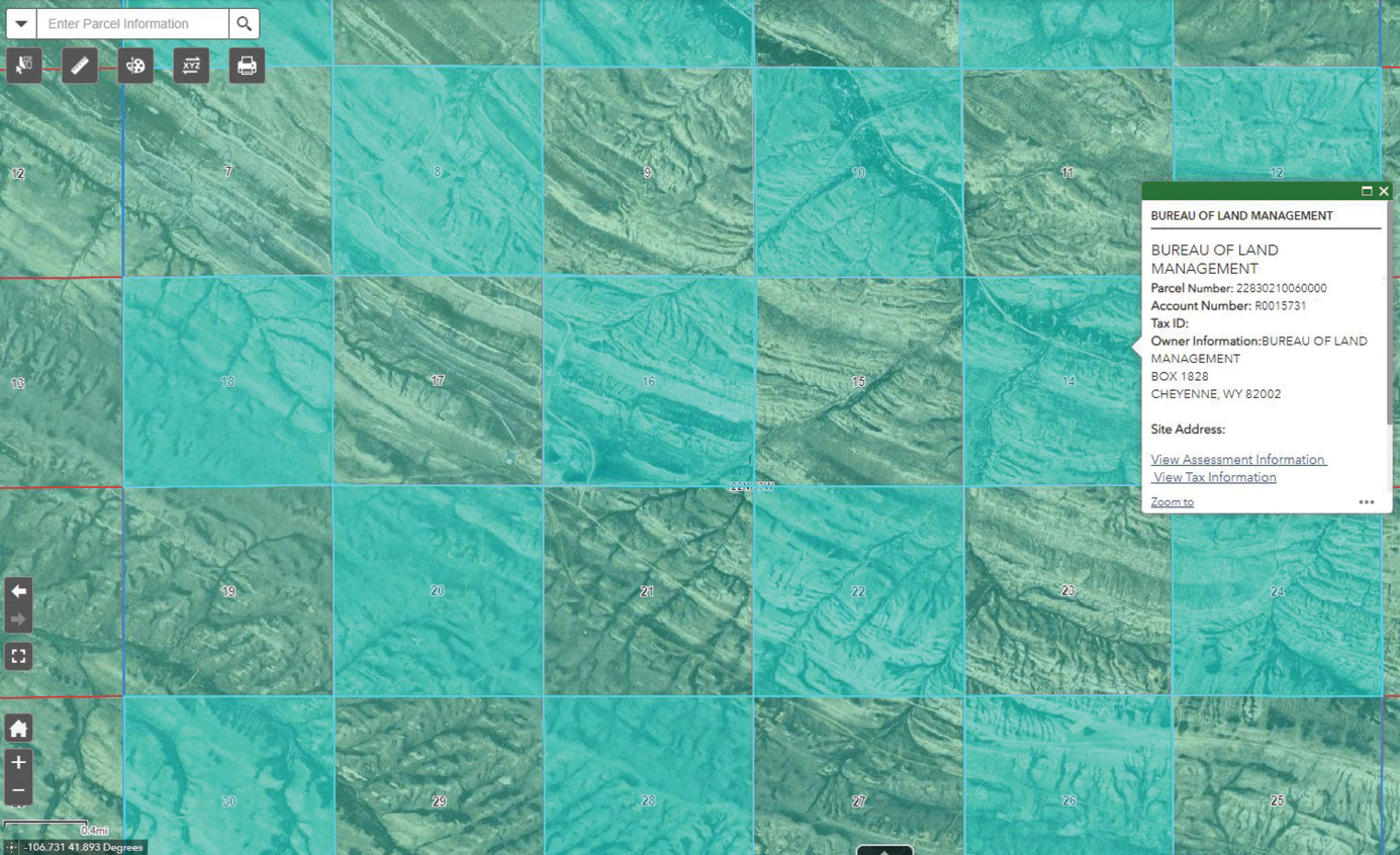
Screen Capture of Carbon County, Wyoming Parcel GIS Map showing the typical checkerboard pattern. Courtesy of Carbon County, Wyoming.
It was in 1967 that GLO DS Gardner described this land as “…rolling to heavy rolling… and …timber, aspen and pine, sagebrush and grass”. Today Elk Mountain is not the highest peak in Wyoming, but it is well known for its scenic beauty, wildlife, and excellent hunting. Elk Mountain is part of the Medicine Bow Mountains, the same mountain range as explored by the John Fremont expedition of 1843, although then called Medicine Butte instead of Elk Mountain. Thanks to the work of Fremont a major river crossing was discovered just North of Elk Mountain and used for the Overland Trail, although this time led by Captain Howard Stansbury of the Corps of Topographical Engineers in 1850. The highest peak in Wyoming is of course Gannett Peak, named after the Quad Father himself, the Chief Geographer of the United States Geological Survey (USGS), Henry Gannett. While Gannett Peak is reported at 13, 809 feet, according to USGS Gannett Peak Cairn from 1968, Elk Mountain is still impressive at 11,155 feet, according to USGS Designation Elk from 1903.

Elk Mountain is home to about 275 Mule Deer, 250 Pronghorn Antelope, 600 Plains Bison, Black Bear, Mountain Lion, Coyote, Marmot, Bobcat, Lynx, Bald and Golden Eagles and of course about 950 Rocky Mountain Elk1. Elk Mountain is different today though. Without Apps, like OnX, you cannot see the checkerboard pattern of mixed ownership and the inability to gain access to the Public Lands.
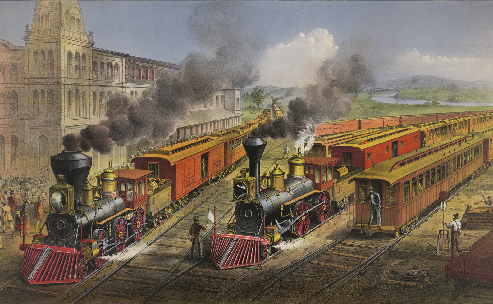
American railroad scene: lightning express trains leaving the junction. Courtesy of the Library of Congress. Public Domain.
Elk Mountain, the subject of this article, is a checkerboard of exactly just that—Private and inaccessible Public land. Most of Elk Mountain, 22,041 Acres to be exact, are owned by North Carolina Pharmaceutical Mogul Fred Eshelman and his LLC—Iron Bar Holdings. On top of that are over 11,000 additional land locked acres within Elk Mountain Ranch that Eshelman likes to call his own keeping everyone else out. The locals call him the “King of the Hill” and he is not afraid to call the game warden and sheriff anytime they see someone trespassing, or at least their opinion of what constitutes a trespass. In October 2021 the sheriff was called, and the four hunters were arrested, but first let’s answer the question of why is there such a checkerboard pattern of ownership anyway?
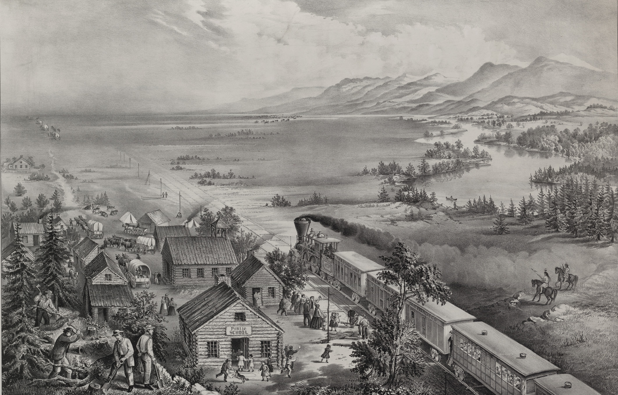
Across the continent, “Westward the course of empire takes its way.” Courtesy of the Library of Congress. Public Domain.
The Pacific Railroad Act was signed by President Abraham Lincoln on July 01, 1862. The purpose of the Act was to connect the Railroads of the East with the those of the West, specifically the Union Pacific Railroad and the Central Pacific Railroad. The document states “…to aid in the construction of a railroad and telegraph line from the Missouri River to the Pacific Ocean, and to secure to the Government the use of the same for postal, military, and other purposes”. The two were to meet at Promontory Point, Utah and it was with this Act, and its financial resources, that would make it succeed.
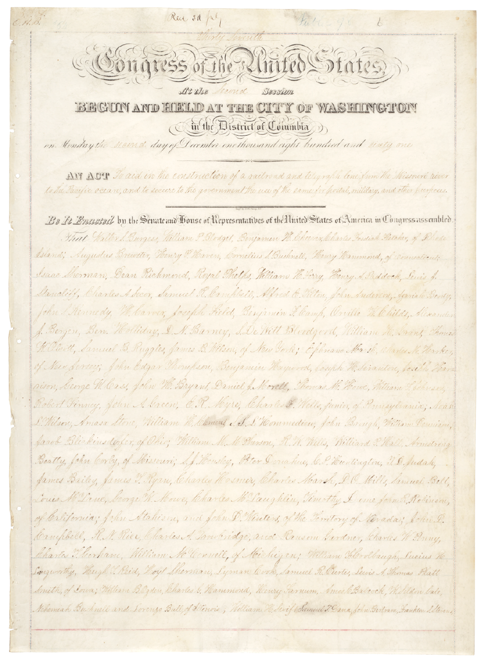
The Pacific Railroad Act of 1862. Courtesy of the United States Senate. Public Domain.
In Section 3, it “… granted to the said company, for the purpose of aiding in the construction of said railroad and telegraph line, and to secure the safe and speedy transportation of the mails, troops, munitions of war, and public stores thereon, every alternate section of public land, designated by odd numbers, to the amount of five alternate sections per mile on each side of said railroad on the line thereof, and within the limits of ten miles on each side of said road, not sold, reserved, or otherwise disposed of by the United States…”.2 In Wyoming alone, the Union Pacific Railroad was given 4.5 million Acres in this alternating, odd section, checkerboard pattern we still see today, especially on an around Elk Mountain. If you study the Layout I made from ArcGIS Pro, you can see the Public Sections are evenly numbered while the Private lands are odd. This data was obtained from the Wyoming Statewide Parcel viewer and the Carbon County Wyoming Parcel GIS Map. For reference, the Union Pacific Railroad Line is about 10 Miles North along the original Lincoln Highway. In total there were over 131 million acres granted to the railroads for western expansion.
What is most interesting about the corner crossing debacle is that there is no current, Federal, law that says you can or can’t corner cross. People on both sides of the fence (pun intended), anyone from hunters to ranchers to environmentalists to even surveyors, have their own strong opinion. Over the years, in various States, legislation has been proposed and has been ignored or were unsuccessful. At the highest level, and used by proponents of corner crossing is The Unlawful Inclosures Act of 1885, ultimately stating that Public Land has to be made accessible. This was the key argument used by the attorneys representing the hunters for their initial arrest and is currently being used for their defense again for their civil suit.
One would think the obvious solution would be an easement by necessity, but this was shot down in 1979 by the Supreme Court in Leo Sheep Co. v. United States. The issue is so confusing in Wyoming, and elsewhere, that the Wyoming Attorney General, in August of 2004, issued an opinion that the Wyoming Game and Fish enforcement officers do not have the authority to make an arrest as corner crossing does not violate Wyoming Statute 23-3-305b (which directly applies to hunting) but also makes it clear that corner crossing may still be a criminal trespass.
An article by Matthew Copland in Outdoor Life quoted Washington Department of Fish and Wildlife Region 1 Enforcement Coordinator Captain Dan Rahn3. Rahn stated “If someone knows where they’re at, and they’re correct, and they step from public to public without setting foot on private land, they’re not trespassing. No Washington officer that I know would cite someone for that”. In 2011, Wyoming House Bill 171, was introduced intending to make corner crossing legal, but it soon became political and perished. Montana tried in 2013 with House Bill 235 but it had the same exact demise, and the same conclusion in Nevada in 2017. To further confuse the situation there is a Bureau of Land Management pamphlet, from 1997, that states an opinion from Lowell L. Madsen that “…corner crossing is illegal and it cannot be done without violating private airspace”. And this leads us to the real question whether corner crossing designates an airspace trespass and who exactly owns airspace in general.
There have been pilots that have landed private bush planes on these exact land locked parcels on Elk Mountain. Consequently, they have also been questioned by the law (at the request of Eshelman) and soon released as they were in full accordance with the law. If an aircraft stays 500 feet above a structure, in an uncongested area, they are clean and clear. Most of us know the rules of unmanned aircraft as a large majority of us are now Part 107 Remote Pilots in Command. We have always been taught that the Federal Aviation Administration (FAA) has authority over the airspace from the top of the grass to 18,000. Furthermore a Unmanned Aircraft System (UAS) is limited by 400 feet and visual line of sight, although many exceptions and wavers exist with these rules. This brings us back to aerial trespass though and if the hunters were in violation of trespassing by simply crossing through the air of a private parcel.
Ultimately this is what is going to be decided in court and could possibly set precedent for the other 9.52 million acres of landlocked Federal Land. All States might be a little different, but Wyoming specifically states, under 10-4-302, that “The ownership of the space above the lands and waters of this state is declared to be vested in the several owners of the surface beneath subject to the right of flight described in W.S. 10-4-303” which states in part “At such a low altitude as to interfere with the existing use to which the land or water, or the space over the land or water, is put by the owner”. Maybe the hunters should have jumped over the corner instead?
This will be an interesting court case no doubt and could change everything as we know about corner crossing. There has been a GoFundMe Corner Crossing Legal Fee Fundraiser set up that has already raised over $116,000 to “…help pay for legal representation for these four hunters”4. The end result may again go Political and may not really change anything , or it could codify things and eliminate the gray area of corner crossing and aerial trespass. The adversaries of this concept go back to the 5th Amendment which states”…nor shall private property be taken for public use, without just compensation”.
We may never see a clear, universal, answer to this question, but there are options to help unlock these Public Lands. These could be access easements, land acquisitions or examples like the tax crediting Unlocking Public Lands Program in Montana which provides access while compensating the landowner. We all know that there are going to be cheaters and scandals in this world, but a codified solution to corner crossing would help everybody out, both landowner and the general public, whether that be hunter, a hiker, a camper or The American Surveyor.
All Wyoming Statutes Cited are categorized by Title, Chapter, Article and Section. In example 10-4-302 is Title 10 Aeronautics, Chapter 4 Uniform State Law for Aeronautics, Article 3 Miscellaneous, Section 10-4-302 Ownership of Space.
For more information read the full report by OnX at: https://www.onxmaps.com/onx-access-initiatives/corner-crossing-report.
Joseph D. Fenicle, MS, PS is a Professor at the University of Akron for its award-winning Surveying/Mapping program. Immediately prior, he was the Chief Surveyor at the Office of the Fulton County Engineer in Wauseon , Ohio for 15 years. He also owns Angular By Nature, LLC, a company specializing in Continuing Education for Surveyors and Engineers across the Nation. Joseph has a MS in Engineering Technology with a Surveying Engineering Technology Concentration from the University of Maine, a BS in Surveying/Mapping from the University of Akron and an AAS in GIS/GPS from Hocking College. He obtained his FAA license in 2019.
1 Elk Mountain Ranch – The Chickering Company. https://chickeringco.com/portfolio-item/elk-mountain/. Accessed December 27, 2022.
2 National Archives NextGen Catalog. https://catalog.archives.gov/id/299953?objectPage=5. Accessed December 23, 2022.
3 Cornered: Western Sportsmen Trapped by Arcane Regulation. https://www.outdoorlife.com/blogs/open-country/cornered-western-sportsmen-trapped-arcane-regulation-prohibiting-public-access/. Accessed December 25, 2022.
4 Fundraiser by Wyoming BHA: Corner Crossing Legal Fee Fundraiser. https://www.gofundme.com/f/corner-crossing-legal-fee-fundraiser. Accessed December 27, 2022.