 This is a hypothetical situation—I want to make that perfectly clear. Any resemblance to actual people, places or projects is purely coincidental. I don’t need a lawsuit, disciplinary action or to retain an attorney for simply projecting current trends into the near future. I am hoping that this little thought exercise will open some eyes, that’s all.
The time: 2022. The place: Reno, Nevada. A routine cease-and-desist letter prepared by a licensing board kicks off a lawsuit, affirms a recent Supreme Court decision and ends professional land surveying as we know it.
The facts are these:
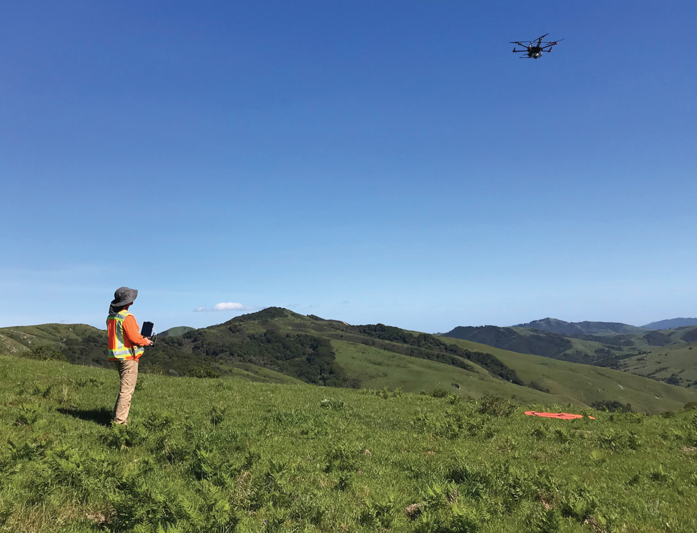
Chet, a longtime hobbyist control-line and remote-control model airplane pilot purchases his latest toy, a DJI Mavic Air drone which comes complete with onboard GPS and GLONASS and a gimbal-mounted 12-megapixel camera. In the process of mastering his new toy, Chet starts dabbling in aerial photography too. While doing some research on-line he discovers that shareware is available which would allow him to produce surface topography and ortho-rectified imagery easily. Chet is an assayer by trade and has an above average intellect. He finds that using the free mapping software is no challenge and soon he is making contours maps, 3-D viewsheds and color orthophotos. He spends another thousand bucks and buys a large format plotter and starts making poster-sized aerial maps for his friends.
 Through connections in the mining industry of Northern Nevada, Chet ends up with an opportunity to fly and map an exploration project comprised of some challenging terrain in central Nevada and make some money doing it. The mapping he produces is first-rate in terms of appearance and the turn-around time was very pleasing to the mining company that hired Chet. Accuracy of the mapping was of course indeterminate since it had occurred to no one that ground control should have been set, and field-checks should have been performed. Chet knew nothing about such things and the folks at the mining company didn’t either. All they know is that they got the mapping quickly and cheaply, and it appears to be on state plane coordinates since it correctly overlays GIS data that the mine has accumulated.
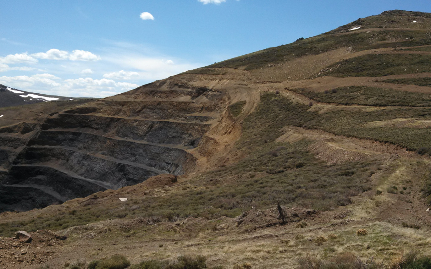
Soon the mining company needed more mapping at a different location—an active open pit mine undergoing expansion and requiring a variety of construction projects, including one where over a million cubic yards of material will be moved during a six-month period. The mine employs a consultant/contractor in a QA/QC role to oversee the operations. The mine’s boilerplate contract language with the QA/QC firm indicates that a Nevada licensed land surveyor must verify all excavation and fill volumes for payment to earthwork contractors. Consequently, the consulting firm employs a Nevada PLS—let’s call him Jones, to do this work. Typically, Jones performs an initial, or ‘original ground’ survey before earthmoving begins on projects such as these.
Unbeknownst to Jones, the mine has hired Chet to fly a large area, including the upcoming project site, prior to construction. Chet’s mapping is provided to Jones as the ‘original ground surface’ and he is required, as is the contractor, to affirm that the surface is correct and will be the one used for all subsequent volumetric computations. The earthwork contractor readily agrees and signs a letter saying so. Jones is hesitant. This isn’t his first rodeo and since the provenance of the mapping is unknown to him, he holds out to perform field-checks of the topo. Jones decides to collect 4 hours of RTK data across the site in all the different types of terrain and insert this data into the mine-provided topo file. He can extract cut/fill data on each of his points and by this method he can get a feel for the overall mapping accuracy. If a uniform factor has to be applied to make the mapping match field data better, he will know about it up front and can make recommendations.
Jones performs his survey and inserts his data into the topo. The results are telling. The east side of the site is high from 0.5 feet to as much as 1.8 feet. The west side is correspondingly low by a similar amount. Points on steep gradients seem to vary greatly from flatter areas nearby. His overall conclusion is that the mapping is not suitable for volumetric purposes. No uniform factor can be applied to bring the mapping closer to the truth. Jones calls the mine’s project manager and says as much. The PM, a mining engineer with no surveying experience and a brutal construction deadline looming, takes the message in, immediately rejects it and instructs Jones to use the surface anyway. Jones argues that he will not willingly use his stamp on any volumes computed from this topo base data. He insists that he perform his own topo survey before the project kicks off. The PM is having none of it and the mine insists to the QA/QC firm that Jones and his firm must be relieved of the project. (Sadly, the firm has no trouble finding a more compliant and cooperative survey consultant to replace Jones and his firm.)
Jones, by now having found out the source of the questionable topo, decides to report Chet and his unlicensed work to the Nevada Board of Professional Engineers and Land Surveyors (BPELS). He packages up the topo, his checks, his conclusion, his correspondence with the mine and files a formal complaint.
The BPELS accepts the complaint and empanels a group of local area surveyors to review the facts. They conclude a violation of Nevada Revised Statutes 625.040 (d) and (f) has indeed occurred.
NRS 625.040 “Practice of land surveying” defined.
1. A person who, in a private or public capacity, does or offers to do any one or more of the following practices land surveying:
d) Determines the configuration or contour of the earth’s surface or the position of fixed objects thereon by measuring lines and angles and applying the principles of trigonometry.
(f) Municipal and topographic surveying.
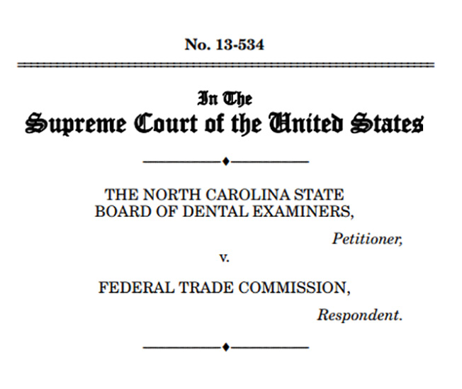 The panel delivers its report to the BPELS Compliance Officer, who in turn reports to the BPELS. At their next meeting, the BPELS votes to write a ‘Cease and Desist’ letter to Chet, which is pretty much all the BPELS is empowered to do. Chet immediately secures the assistance of a friend in Reno who happens to be a practicing attorney, let’s call him Jack. Jack is a run-of- the-mill ambulance chaser but he does keep up with legal precedent and is well aware of the 2015 U.S. Supreme court case 13-534 in which the Federal Trade Commission sued the North Carolina Board of Dental Examiners for trying to prevent an individual from offering teeth-whitening services by asserting that teeth-whitening is part of practicing dentistry and therefore falls under the board’s purview. The 6-3 Supreme Court decision hinged upon a technicality: that a board made up of active practitioners is inherently susceptible to restricting free trade and therefore is not granted immunity from antitrust action. The FTC suit was upheld.
Jack looked at his friend and client’s cease and desist letter and saw clear parallels. In his estimation a market was being unfairly closed to his client. He and Chet decide to counter the Nevada BPELS on the grounds that they are restricting free trade. Jack contacts the Federal Trade Commission and finds a sympathetic ear from the get-go. The FTC contacts the NV BPELS and threatens to sue if they don’t rescind their letter to Chet. The BPELS declines to back down and the FTC files a lawsuit indicating that their attempt to prevent Chet from providing mapping services is an unfair restriction of free trade—in effect a violation of the Sherman Antitrust Act. And unfortunately for the BPELS, precedent has already been set via the aforementioned U.S. Supreme Court case.
In the aftermath of this legal kerfuffle, the NV BPELS finds itself no longer able to effectively prevent unlicensed purveyors of mapping services. Nevada contractors, sensing an opportunity, start asserting that grade-setters with GPS and machine-control technology are similarly immune from regulation. Surveyors from out of state no longer feel bound to apply for licensure to perform certain kinds of work within Nevada, since any attempt to rein them in would be a restriction of free trade. GIS firms with no licensees start offering what can only be called ‘geodetic’ services. Like a snowball rolling down a mountainside, the greater Surveying Marketplace becomes crowded with diverse entrepreneurs who produce great facsimiles of traditional survey work products, faster and cheaper than we do. This is great for the market and the consumer, as long as quality of the product is not looked at too directly.
In the time before this took place, and the year and a half between Jones’ complaint and the FTC legal victory, NCEES, NALS, WFPS and NSPS all had their attention focused on workforce development and license mobility, not perceiving that a much more fundamental threat to the very essence of licensure was underway. After the NV BPELS—FTC lawsuit, the value of having a professional license in the west was greatly diminished because the needs of the marketplace became paramount, at least in the eyes of politicians and bureaucrats and the hacks we call journalists these days. Any attempts at mounting an effective defense of regulation boards, centered on protecting the public from unlicensed and unqualified practitioners, was muted, at best. The term ‘missed opportunity’ does not adequately convey the disaster that ensued once the BPELS lost its ability to regulate the practice of Land Surveying.
Fortunately, this scenario has not played out yet—really it’s just the product of the author’s overactive imagination; dreams brought on by eating Indian food too late one evening and the restless sleep that took place afterward. But the whole thing is plausible to the point of being almost inevitable and all of the surveying facts cited have taken place in Nevada dozens of times in recent years with respect to mining and construction projects. There are plenty of ‘Chets’ out there, but for whatever reason we don’t tend to report their unlicensed activities like we should. So far there hasn’t been a ‘Jones’ sufficiently concerned to file such a complaint, (that I have heard of anyway). I have to believe that ‘Jacks’ are lining up around the block for opportunities like the one described herein.
Don’t say you weren’t warned.
Carl C. de Baca, PS, is a Nevada and California licensed land surveyor. He served as President of the Nevada Association of Land Surveyors, and has served on the Board of Governors and Board of Directors of the National Society of Professional Surveyors. He owned a business serving the mining industry for 11 years.