- The Mean Center of Population for the 2020 Decennial Census was near Hartville, Missouri.
- Later in 2022, the U.S. Census Bureau and NOAA’s National Geodetic Survey will host an event commemorating the 2020 Mean Center of Population and unveil a commemorative geodetic survey mark in Hartville.
- Local and regional surveyors can then use this mark as the starting point for the many everyday applications of geodesy, from housing and road construction to floodplain mapping and precision agriculture projects.
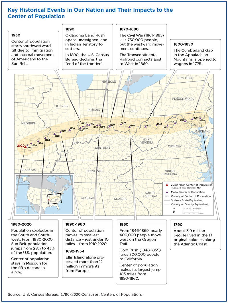
The Mean Center of Population, as defined by the Census Bureau, is “the place where an imaginary, flat, weightless, and rigid map of the United States would balance perfectly if all residents were of equal weight.” Since it was first measured in 1790, the Mean Center of Population has tracked the movement of Americans out West and to the South. Beginning with the 1960 census, the Census Bureau and NGS have worked together to establish a geodetic control mark at or near the computed location of the Mean Center of Population.
The 2020 Mean Center of Population is in central southern Missouri. This spot in Missouri’s Wright County is 14.6 miles from Hartville, a town with a 2020 Census population of 594. This is the fifth decade in a row that the national center of population has been located in Missouri. In 1980, the center of population moved from Illinois to a location near DeSoto, Missouri, and has remained in the state ever since. In 2010, the center of population was in Plato, about 30 miles from the 2020 center.
The geodetic survey mark that the Census Bureau and NOAA will unveil at Hartville will become part of the physical national geodetic infrastructure that makes up the National Spatial Reference System, the nation’s precise coordinate system that serves as the foundation for accurate mapping and charting in America. Just as Hartville is now at the “heart” of the American population, geodesy, or accurate location science, is at the center of applications that literally help people navigate their everyday lives whether they are on land, sea, or in the air. Geodesy and geodetic infrastructure–like survey marks–are central to the work of surveyors who play vital roles before, during, and after development and in infrastructure projects conducted by architects, engineers, and construction professionals.
The commemorative survey mark that NOAA and the Census Bureau will install at Hartville is near to the official coordinates for the 2020 Mean Center of Population, which are 37.415725 north latitude and 92.346525 west longitude.
- Designation: TBD once mark is set

- PID: TBD once mark is set
- Datasheet: TBD once mark is set
- Year: 01-01-2020
- Location: Hartville, Missouri
- Latitude/Longitude: +37.415725 / -092.346525
- Event Commemorated: Completion of the 2020 census