
Map showing 1906 campsite. Small squares are sections.
This story involves two energetic young men who were among the predecessors of one of Mill City’s prominent early residents, Pete Parsons, also known as an avid walker, with or without trails or roads.
There have been trails through the valleys and mountains of Oregon for centuries. They range from game trails made by deer and elk to Indian trails, those located by early explorers and trappers, and then from about 1850 forward, by early settlers. One of the notable trails in the upper North Santiam drainages was first blazed by John Minto in about 1872 and a small segment is still intact IF you know where to look for it! Probably the first “organized trail building” in this area was after the creation of the “Forest Reserve Act” by Congress in 1891, with the reserves to be administered by the Dept. of the Interior. In 1893, the first reserve created in Oregon was the Bull Run Reserve to protect Portland’s water supply and contained 220 square miles.
The second was a reserve to protect Ashland’s water supply and was only 29 square miles. The third was the Cascade Oregon Forest Reserve which was 235 miles long along the Cascade crest and contained over 7000 square miles. In addition to hiring Deputy Surveyors to survey section lines, the General Land Office was also in charge of these and other reserves and the Superintendent of the Cascade Reserve was a gent by the name of Captain Salmon B. Ormsby, who hired and supervised “forest rangers” to open trails, fight fires, etc.

Route from the North Santiam River to Jefferson Park and Mt. Jefferson.
I came across an article about a trip up Minto Mountain in 1900 which reported: “the trail up Minto Mountain was opened for us by the forest rangers Messrs Parrish, Heness(sic), Heseman, and White, under superintendent Ormsby, and to these rangers, we were indebted for many favors during the trip.” A GLO (General Land Office) survey map in 1894 shows “Bowman’s Trail up Minto Mtn”, undoubtably being the one referred to in the 1900 article above. This GLO management continued until 1905 when the US Forest Service was created within the Dept. of Agriculture.
In 1908, the northern portion of the “Cascade Reserve” was broken down into the Oregon National Forest and the Cascade National Forest. The dividing line between the two was the Willamette Valley and Cascade (Santiam) Wagon Road, roughly where Highway 20 now runs today along the South Santiam River. In 1911, Oregon National Forest was further divided into the Mt. Hood NF and the Santiam NF with the common boundary being approximately the north limit of the Breitenbush River drainage. In 1933, the Santiam and Cascade NFs were combined to become today’s Willamette National Forest. The trail that is the subject for this article was located in the Breitenbush area near the head of East Humbug Creek. It was near the ridgetop between East Humbug Creek and Elk Lake Creek about 4 miles northeast of Gold Butte Lookout.
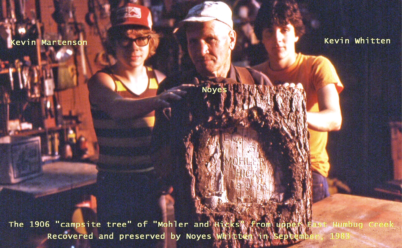
My dad, Noyes Whitten, my son Kevin, and his classmate Kevin Martinson after returning with the sawed-out scribing.
In 1983, my dad, Noyes Whitten, was looking at a proposed Forest Service Timber Sale near the head of East Humbug Creek. He came across what he thought was an old Indian trail beside a shallow little lake about 50 feet across. A few hundred feet farther down the trail he found a spring with a lot of obsidian chips nearby and a large hemlock tree with a foot square blaze that had been scribed as follows; “Elevation 3100 Mohler and Hicks 8-9-06”. He didn’t bid on the sale but did go back there a few months later and sawed the chunk containing the scribing out of the tree. The impending logging would have destroyed it otherwise.
I recognized the name Mohler from a 1907 Mazama “Annual report” that I had seen at the Kerr Library at OSU in 1967. In that “1907 report” was an article authored by L.J. Hicks, a member of the “Mazamas”, that wrote about a trip he had made with Sidney Mohler in August of 1906. (The “Mazamas” were (and still are) a mountaineering club organized in 1894 on the summit of Mt. Hood.)
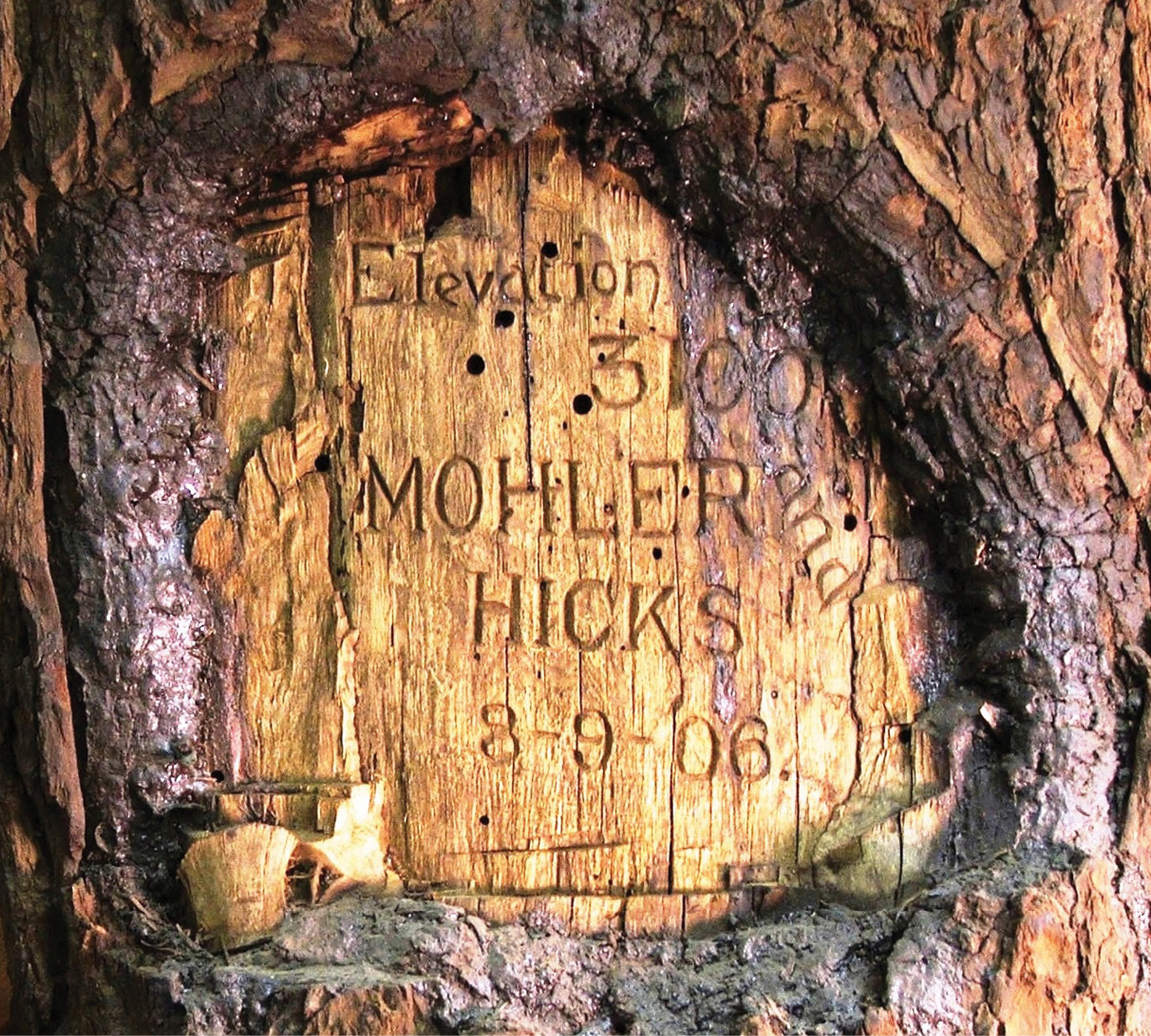
Close up of the 1906 scribed “face.”
I have been a land surveyor for over 50 years and have seen a lot of old scribing by deputy surveyors (1851 to 1910) and have done a fair share of scribing myself. I have never seen letters and numbers so carefully and neatly made! I surmise that Mohler and Hicks probably camped here for a day due to rain, for it would take a long time to make these marks, especially with only a jack-knife. The “Indian trail” was probably re-opened by the GLO in about 1900 since there were mining claims filed in 1890 about 2 miles to the northwest. In August of 1906, S.S. Mohler and L.J. Hicks left Wilhoit Springs, a few miles east of Scotts Mills, on a walking trip to Mt. Jefferson.
Sidney Sumner Mohler was born in Minnesota in 1880 and was a contract painter living in Oregon City in 1900. He had climbed alone from Jefferson Park to the top of Mt. Jefferson in 1903. L.J. Hicks and was “scouting” the Jefferson Park area for a planned Mazamas outing there in 1907. From Mohler’s home in Oregon City, they went southerly to Wilhoit Springs, east of Scotts Mills.
They then followed a trail east to the Molalla River, thence northeasterly past Rooster Rock, to the area of Table Rock. They then dropped easterly, down to Bagby Hot Springs on the headwaters of the Collawash River. From there the route would be southeasterly past Bull of the Woods, on various trails, to Elk Lake Creek and then up to the ridgetop where they camped and marked their names on the tree. This would be about two days travel from Wilhoit Springs.
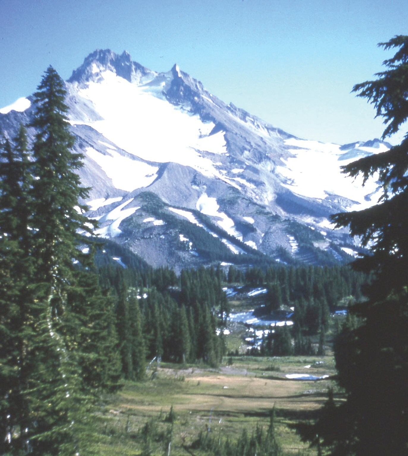
Looking south towards Mt. Jefferson from Jefferson Park. Mohler and Hicks climbed easterly along the right skyline to the summit pinnacle at the far left.
After a rainy day in camp, they would have gone southwesterly, via a ridge trail about 5 miles to Elk Lake, and then down the West Fork of Humbug Creek to the Breitenbush River. They then would have followed the Breitenbush down to Detroit and then easterly along the Oregon Pacific railroad grade to Tunnel Creek where it had ended in 1889. From there they obviously followed the Minto Trail (circa 1880s) for a mile to Whitewater Creek and then turned off and headed east about 8 miles to the foot of Mt. Jefferson. At this point there is a gigantic rock formation between Whitewater and Russell Creeks. It is 1000 ft high and has cliffs all around it, which Mohler and Hicks called “a great overhanging rock and a sheer drop of 700 feet” about a mile from Jefferson Park that they called “a mountain park which has lost none of its primeval beauty”.
In 1903, Mohler had taken a “flagstaff” to Mt. Jefferson’s summit pinnacle. When he and Hicks were there in 1906, they found the small flagstaff left by Mohler 3 years before, which was a “stout green stick, splintered to the base, presumably by lightning”. They then “planted securely in the rocks a flagstaff 12 feet long with their names and the date engraved at its base”. They returned to their camp in Jefferson Park by about 5 o’clock.
The next day, it was decided to return to Oregon City by the “crest-line trail” which had been located by Adolf Aschoff (an early member of the Mazamas) who was the former supervisor of the forest rangers. It ran from Mt. Hood to Mt. Jefferson and Mohler and Hicks found it to be “almost as level as a floor for nearly 50 miles”. After about 42 miles, they reached Clackamas Lake and then went down the Clackamas River to Oregon City. As Hicks later put it, “They had already killed three deer, had enjoyed fresh fish for dinner every day, and ascended one of our most difficult mountains by a new route, and were in prime physical condition from their two-hundred-mile walk, so that they felt well repaid for their twenty-three days outing.”
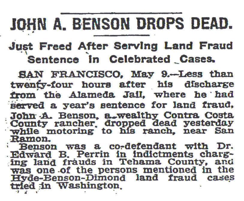
This article appeared in the September/October 2021 edition of “The Oregon Surveyor,” a publication of the Professional Land Surveyors of Oregon. It won the PLSO 2021 Article of the Year award. Running with it was the Wikipedia article about the champion of fraudulent surveys, The Benson Syndicate.
C.E.“Chuck” Whitten graduated from Santiam High School in Mill City, OR in 1963. He then went to Oregon State University and graduated in Forest Engineering in 1967 and then was hired by the Washington Department of Natural Resources from 1967 to 1972, working on road location and surveying for timber sales. From 1972 until retirement in 2009, he was a project manager and vice-president for Hagedorn, Inc., a private surveying/engineering firm in Vancouver, WA. Since then, he has enjoyed retracing original GLO surveys. In June, 2021 he was hired by the Marion County Surveyor in Salem, OR to recover section corner evidence in 6 townships devastated by the Beachie Creek and Lionshead Forest Fires of 2020.
The Benson Syndicate
From Wikipedia, the free encyclopedia
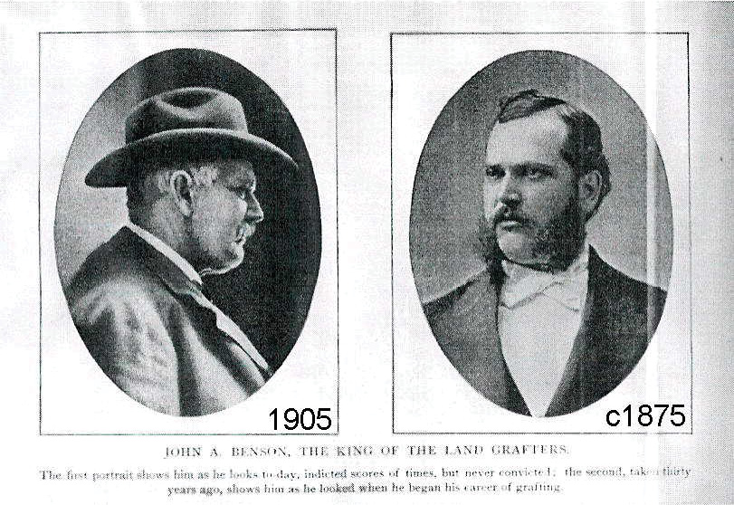 The Benson Syndicate was an organized crime organization in the western United States which received contracts from the General Land Office (GLO) to perform land surveys of the public lands. It was led by, and named after, one John A Benson (1845–1910), a former school teacher, county surveyor and later a reputable deputy surveyor, Mineral Surveyor and Civil Engineer.
The syndicate operated from the Rocky Mountains to the Pacific, but was most active in California and was headquartered in San Francisco. Its tenure ran from about 1875 to 1898 and was at its peak from 1883 to 1886. In California alone, at least 40 individuals were known to be involved, and very probably more actually were. Its modus operandi was to generate false demand for public land surveys (see Public Land Survey System) using fictitious land patent applications, followed by contracting with the GLO for the survey of these lands. The surveys were then fraudulently executed, being either shoddy, incomplete or outright fictitious. These “surveys” were “performed” under contract to individual deputy surveyors, some of whom were not even aware that the surveying contracts existed in their names, having been induced by Benson to sign blank papers which were later turned into contracts and other legal documents without their knowledge.
Extent of operations
At other times, people with minimal—or even no—surveying experience and/or lacking proper qualifications as deputy surveyors, performed the work without the contracted surveyor ever being physically present, which was patently illegal. Often, an area under contract was surveyed only to the extent that was necessary to create plausible, but fabricated, survey plats and field notes for the remainder of the area. Other times, entire contracted areas, usually consisting of several survey townships (36 square miles), were fabricated by syndicate members at the San Francisco office, with little or no work on the ground at all (see below).
 Benson’s organization infiltrated into very high levels of the government, and syndicate members in governmental positions as well as members of congress made the group’s schemes possible. For example, in California at least two Surveyors General in the 1880s approved numerous fraudulent survey results and approved requests for government payment that were 200 to 700 percent of the originally estimated survey cost, which the government paid.
Theodore Wagner was especially notorious in this regard, and his appointment as California Surveyor General coincided with a large increase in the group’s activities and power. Others approved contracts that had originally been rejected (after inspection by independent government examiners), without evidence or assurance that the surveys had been properly corrected or completed. Also, at least one such examiner in California was part of the syndicate, attempting to gain payment for some rejected surveys via bogus field “examinations” (which were themselves later rejected as fraudulent as the extent of the group’s activities became known). Banks were also involved, providing the deposits and performance bonds required by the government, in exchange for a cut of the enormous profits generated. These banks later also paid for the syndicate’s defense attorneys in trials brought by the government in its failed, ten year effort to convict the syndicate members and recover funds paid for fraudulent work.
Reports of the Commissioner of the General Land Office
1887
Detailed information on the Syndicate’s history remains fairly sparse. Two Annual Reports of the Commissioner of the General Land Office provide a glimpse of the group’s activities. The Report for 1887, pages 25–26, gives this summary of their schemes:
“In April last the United States grand jury at San Francisco returned forty one indictments for perjury and conspiracy in connection with fraudulent surveys of the public lands…The operations of this syndicate were not confined to California, but extended to the States of Nevada, Oregon and Colorado, and the Territories of Arizona, New Mexico, Idaho, Montana, Utah, and Washington. Its purpose was to control all surveying contracts in these States and Territories under the deposit system, to manufacture settlers’ applications for surveys, to file in the offices of the surveyors-general fictitious field notes of surveys and alleged surveys, and to draw from the Treasury of the United States large sums of money on fraudulent surveying accounts.”
“The principal portion of the contracts were let in the names of thirty-four alleged deputy surveyors, of whom three were “dummies”, two were intimately connected with the surveyor-general who approved the bulk of the contracts, and the remainder were relatives, partners, associates, or employees of the head of the syndicate. There was paid to the order or purported order, of these thirty-four pretended deputy surveyors upwards of $1,000,000, all of which went into the treasury of the syndicate, the parties used as tools being paid stated salaries by the syndicate for the use of their names and services. Three of the alleged deputies, to whom upwards of $190,000 appears from official records to have been paid, have sworn that their names were used without their knowledge, that they never had a surveying contract, and never received the amounts shown as paid them, and one swears that he never did a day’s work in his life at land surveying and knows nothing of the business.”
“Every expedient known to legal ingenuity has been resorted to by defendants and their confederates to avoid and defeat trials on the indictments found, but it is hoped and expected that at the next term of the court the trial and merited conviction of guilty parties to this stupendous scheme of fraud, perjury, and public robbery which has been developed, will be secured.”
1888
The 1888 Report, pages 186-187, provides this description of one fictitious survey of three survey townships in the high Sierra Nevada, southeast of what is now Yosemite National Park:
“Township 7 South, Range 25 East and Township 8 South, Ranges 24 and 25 East, Mount Diablo Meridian: These townships are very rough, intersected by deep canyons and very steep, almost impassable mountains, in part covered with dense chaparral. Six weeks before the deputy claims to have commenced his surveys, all the people who live there in the summer are driven out by the snows, all business is suspended, and the mountain country abandoned. A comparison of the original field notes, transcript notes, plats and report of the examiner, shows that at the season of the year (from December 1, 1884 to January 3, 1885) when the deputy pretends to have made the surveys, the deep snows made the survey at that time impossible; that in the original notes (which are now in this office) much is omitted that is found in the transcripts and data supplied from memory, or rather made up; that disregarding clerical errors the transcripts are not in any sense copies of the original notes; that triangulations omitted in originals are audaciously given in detail in the transcripts, just as if they had really been made in the field, that the high speed, more than 6 miles per day, at which it is pretended the work was executed, surpasses belief when we take into consideration the nature of the ground, and bear in mind that the surveying was done during the shortest days of the year; that the deputy gives descriptions of erroneous bearing trees where no such trees, either as regards size or species, are to be found; that in the face of all the embarrassing conditions, big canyons, high and steep mountains, deep snow, impenetrable chaparral, precipices impossible to ascend or descend, the deputy with his two parties of four men each, frequently with the impassable San Joaquin river between them, pretends to have subdivided T8SR24E at the rate of more than 6 miles per day, and then accomplishes the feat of recording all this work in one field book. The conclusion is that the deputy did not make the surveys of these townships according to his field notes and that the notes are in large part fictitious and fraudulent.”
Government action
It was completely implausible survey results such as these, as well as the sworn testimony of disenchanted employees or associates, that led to the recognition of the widespread fraud of Benson’s group. Beginning about 1886, contracts held by certain surveyors thought to be aligned with Benson were not paid by the government, leading to various lawsuits. In 1887, forty one federal indictments for conspiracy and perjury were brought against Benson and several others, as mentioned in the Report quote above. However the trials, in federal district court, did not even occur until 1892, and when they did all were found innocent on legal technicalities. However their actual guilt was clear to everyone familiar with the facts, and surveyors associated with Benson had difficulty getting work. Because of this, Benson proposed what came to be known as the “Benson Compromise” in 1895 to the California Surveyor General, which proposed to correct or finish the survey work on several contracts that had never been paid out because government examiners had declared the work bogus. This compromise was accepted by the government, but little of this supposedly “corrected” work is reported to have ever been accepted by the Surveyor General as valid.