Mt. Jefferson (2nd highest mountain in Oregon). Clearing (left center) is location of GPS point used to tie South Quarter Corner of Section 32 (12,000ft away)
Initially I had intended to write a tale of a “survey trip” that I made in July of 2019 about the retracement of a portion of the Second Standard Parallel South, W.M., east of Detroit, Oregon. The original survey of this segment of the Parallel had been first completed by U.S. Deputy Surveyor William E. Campbell in August and September of 1891 under Contract Number 563.
He had a penchant for calling Line Trees in his notes and marked 20 of them in the first mile and a half between the SW corner of Section 31 and the South Quarter Corner of Section 32, starting his work on September 11, 1891. I had found and tied a lot of these line trees on the south line of Section 31 previously and wanted to search the next half mile to the east for several more and then look for the South Quarter corner of Section 32 that I believed had not been visited since Campbell set it in 1891.
 I knew from the topo map that once Campbell crossed the ridge at 27.50 chains (1815 feet from the SW corner of Section 32) the line became “steeper than a cows face”. In the bigger picture, I wanted to also look for the closing corner for Sections 4 and 5, T11S, R7E, set three years later by William Bushey in 1894 and then the SE corner of Section 32, set by Campbell.
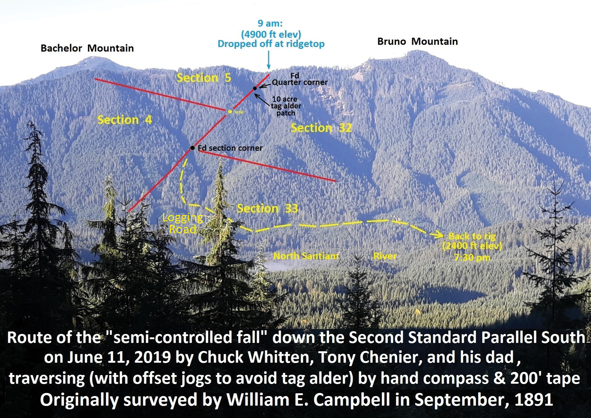
 Knowing that there was a logging road on the west side of the North Santiam River, my plan was to begin at the ridgetop and continue easterly (down the steep hillside) to end up on the “logging road.” On June 11, 2019, a fellow surveyor (and avid mountain climber) Tony Chenier, who lives in Kelso Washington, met me in Battle Ground Washington, where I live. We then headed south to Stayton Oregon (about 12 miles southeast of Salem Oregon to meet Tony’s dad Jim, who was going to accompany us on the “walk”. We then headed east on Highway 22 for another 18 miles to Mill City where we met my friend Alice Bickett, whom I had recruited to leave my pickup on the “logging road” at the bottom of the hill.
 She then followed us in her car for 33 miles to the “bottom of the hill” where she left her rig and got in with us. Then it was another 18 miles to finally get to the ridgetop. It was east, only 1 ½ miles in a straight line to the “logging road”, but about a half mile in elevation above it. Alice then circled back to the “logging road,” left my rig, got in hers and went back home.
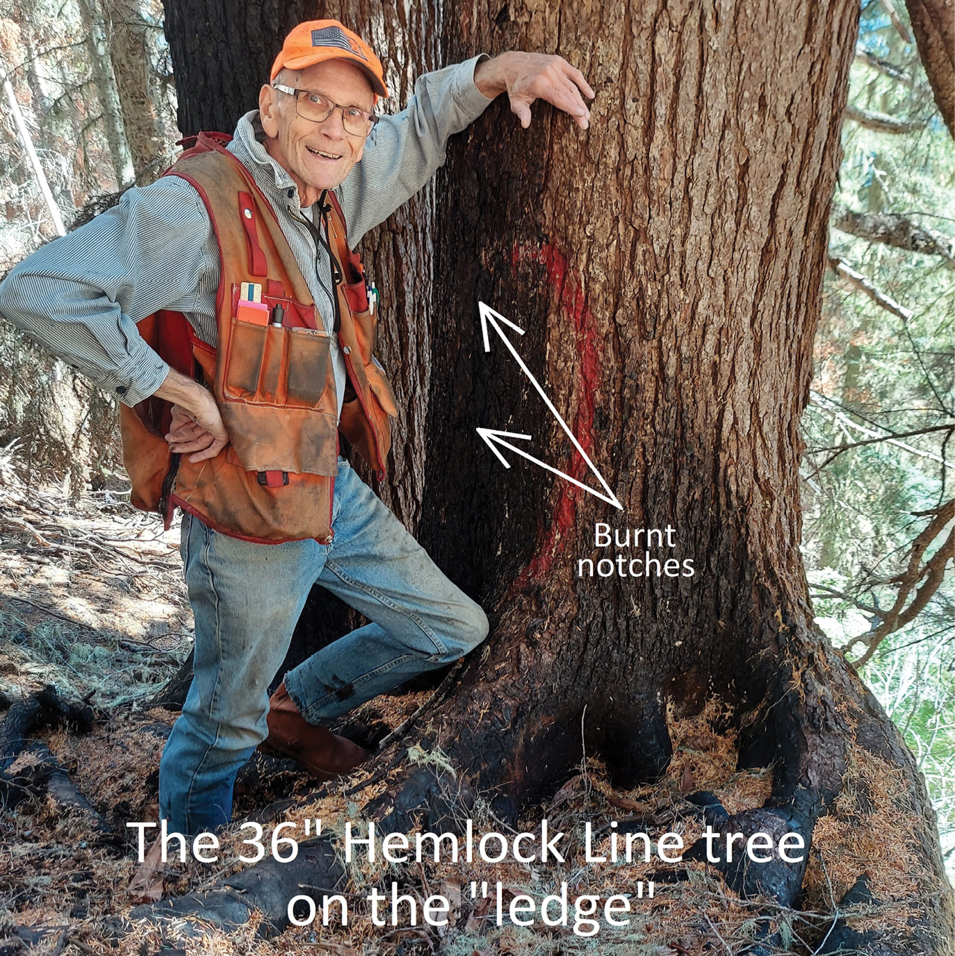
 I had run a compass line east from the SW corner of Section 32 the month before, looking for line trees and stopped on the ridgetop (at 27.50 chains in the notes), leaving a ribbon where we now stood. I put Tony on line with my hand compass and we started chaining east, down the hill, with a 200 ft rag tape, correcting for slope with a clinometer. (The slope was from 40 to 45 degrees+!) We found the first line tree (a “White Fir, 10” dia.”, now actually a 26” Hemlock with notches on the west side only) at 36.09 chains (567 feet) and the next one, “a Hemlock 20” diam.”, now a 36” Hemlock with overgrown notches on both the east and west sides), at 36.62 chains, 35 feet past the previous one.
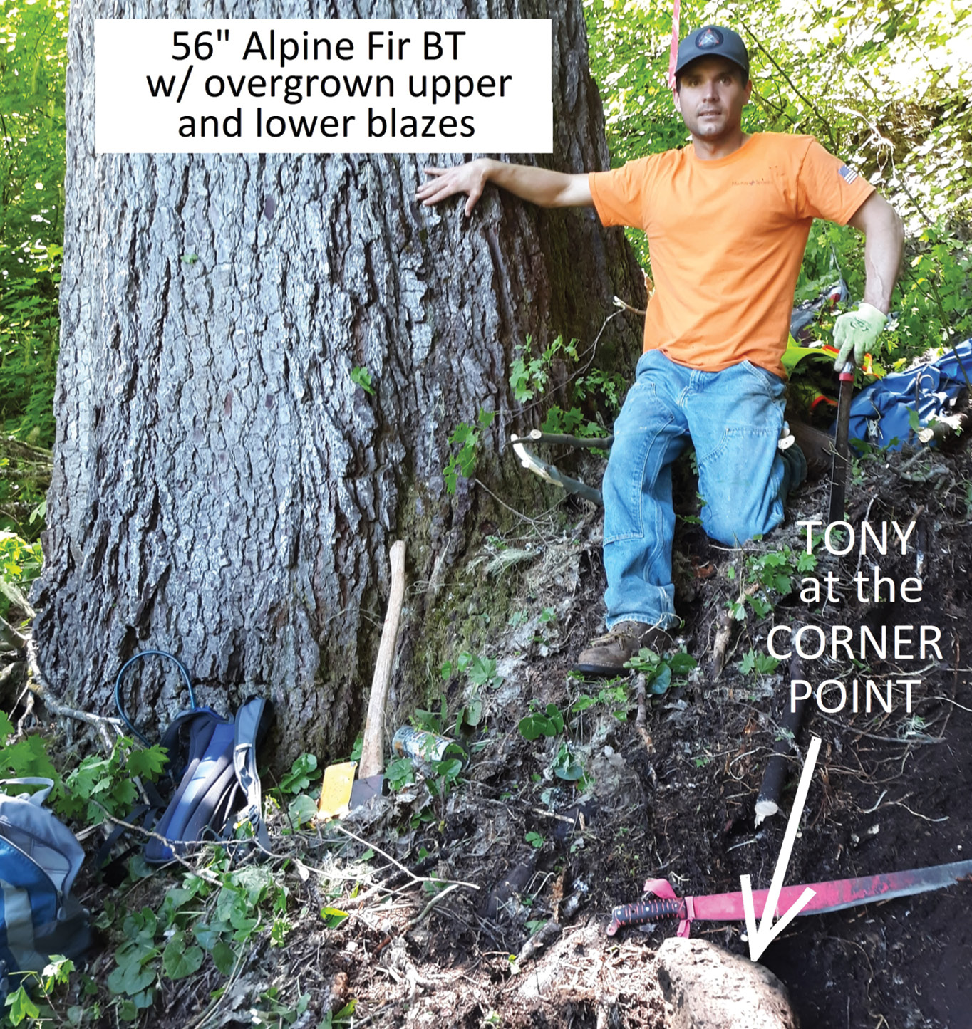
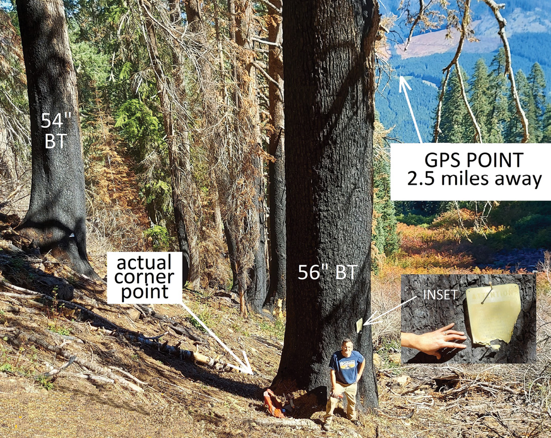
 I painted a big red circle around the two notches, being careful not to paint the notches themselves. This 36” Hemlock was odd in that it was growing on a ledge about 7 feet high. The ground on the west (upper) side was about 7 feet higher than the ground on the east (lower) side. It was also interesting in that there was a limb on the lower side that would have prevented Campbell from chopping the 2 notches into the east face of the tree. We could see the slanted “axe tracks” on that now dead limb that were obviously made in September of 1891. We then continued to chain down the hill and within 5 feet of the record distance (3.38 chains (223 feet) we found ourselves beside the original BT, now a 56” Alpine Fir (Campbell called it a 28” Larch, the common name for Noble Fir.)
 Traces of the upper and lower blazes were still faintly visible in the bark on the north side. Campbell’s record call to this BT was “S 20° W, 10 links (6.6 feet). We “backed off” N 20° E, 6.6 ft from the center of the now 56” BT and stuck a nail in the ground. The northern BT (Campbell called it a Larch, 20”) was “N 12° W, 28 links” (18.5 feet). This tree was now a 54” diameter Alpine Fir, also with faint axe marks in the bark.
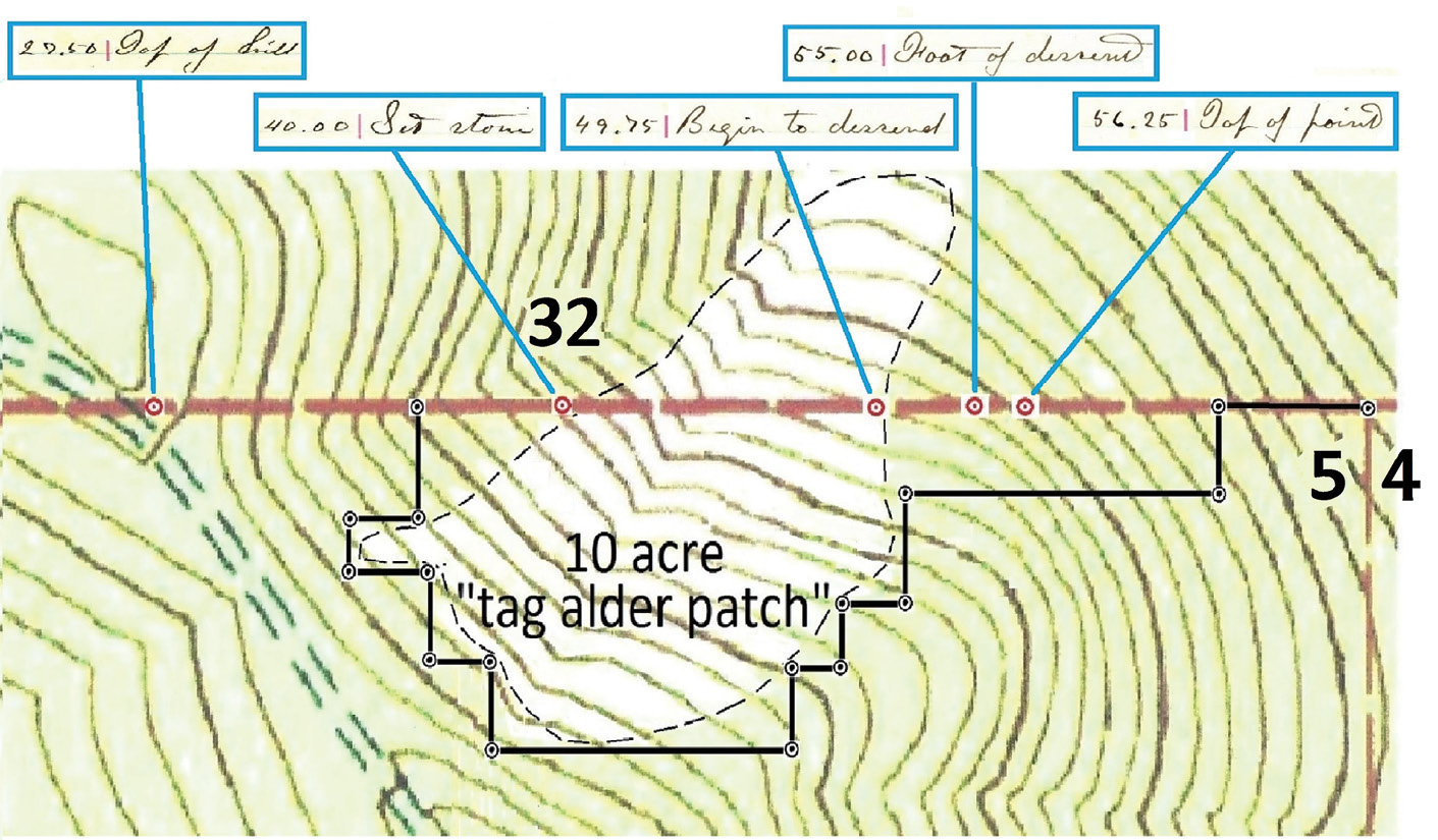
There seemed to be about 5° of “local attraction” alongside the big talus slope, now covered with 10 foot high “tag alder”, actually called “White Alder” (Alnus Rhombifolia as I recall). We chose to arc the record distances from the center of both BTs and moved the nail about a foot. Then we started to dig through the “duff” and cleared a 3 ft diameter area in search of Campbell’s monument which he described as “Set Basalt Stone, 16 x 10 x 6, 10 ¾ ins in the ground, for Standard ¼ Sec. Cor., marked S. C. ¼ on N. face”. We found a couple big rocks, both with scratches, but not what I would accept as the actual “stone.”
 I had seen several of Campbell’s “Standard ¼ Section stones” further east and they were plainly marked as he described. I felt that we were within a foot or so of where the 1891 stone was originally set, but concluded that it had probably rolled or slid down the hill on the 100 percent slope, like so many other “stones” I had “found” in the township. We then replaced the nail with a “rock,” 7” x 9” x 20”, found nearby, and put up USFS 54-3 and 54-9 signs, chopped a base blaze and nailed a plastic washer to it, and painted blue bands on the two BTs. I could not get a sub-meter GPS position here at the S Qtr Cor of Sec 32 because there was not enough sky visible.
 For the purposes of this township retracement, which is obviously not 3rd Order, I have been rounding all the coordinates to the nearest foot since we’re not “building a piano”. Tony then volunteered to lead the way, continuing the line east through the tag alder, but I felt that without a chain saw, it would take several hours, which we didn’t have to spare. I suggested that we just go back up the hill about 400 feet and start chaining south (to avoid the tag alder) from one of the “stationed points” I had ribboned on the way down from the ridgetop. After some “cussin’ and discussin,’ we agreed to go with “plan B.”
Chuck Whitten, PS
We jogged south a few hundred feet but hit the tag alder, so we had to retreat west another 130 ft. We turned south again for another 100 feet and then started east, parallel with the “Parallel” and kept bouncing off the tag alder several more times until we were finally past it 564 feet south of the Parallel. We now had clear sailing and jogged back to the north every chance we got till finally regaining the Parallel.
Campbell’s notes called for a “Top of Point” about 1100 feet east of the quarter corner we just left. That seemed strange since there was no indication of such a feature on the topo map. When we got close to that “easting,” Tony called out that he could see the “point”! Sure enough, on that hillside, there was a rocky protrusion rising up that Campbell had hit dead center with his section line.
 It was a good reminder that most of the “modern USGS quads” were made from aerial photos that are really just pictures of the “treetops.” The resulting contours are actually modeling the “treetops” and then adjusted vertically for a guess at how tall the trees are. Several months later, I found some “lidar coverage” of this area and the actual “ground” amazingly shows the “point” (see Lidar image below).
Continuing our chaining east, when we neared the area for Bushey’s closing corner, it was becoming obvious that his BTs had burned up. The present timber stand looked to be only about 80 years old (should have been about 130 years of age). Consequently, we found no trace of his BTs for the closing corner between sections 4 and 5, T 11 S, R7E, as set in 1894. We continued east another 1000 feet or so and finally spotted a sign on one of the BTs for the southeast corner of Section 32. From this point on, we kept stumbling down the hill following the “path of least resistance” till we at last stepped out on the logging road at about 7:30 and then arrived back in Battle Ground 3 hours later.
 In September of 2021, I recruited my son Jeff, a civil engineer and also a veteran of many “survey expeditions” over the past ten years, to accompany me. My mission now was to make survey ties to the two line trees that Tony and I had found 2 years earlier. I was curious to see how far “off line” they actually were and to also look for a few more line trees near “the ridgetop.”
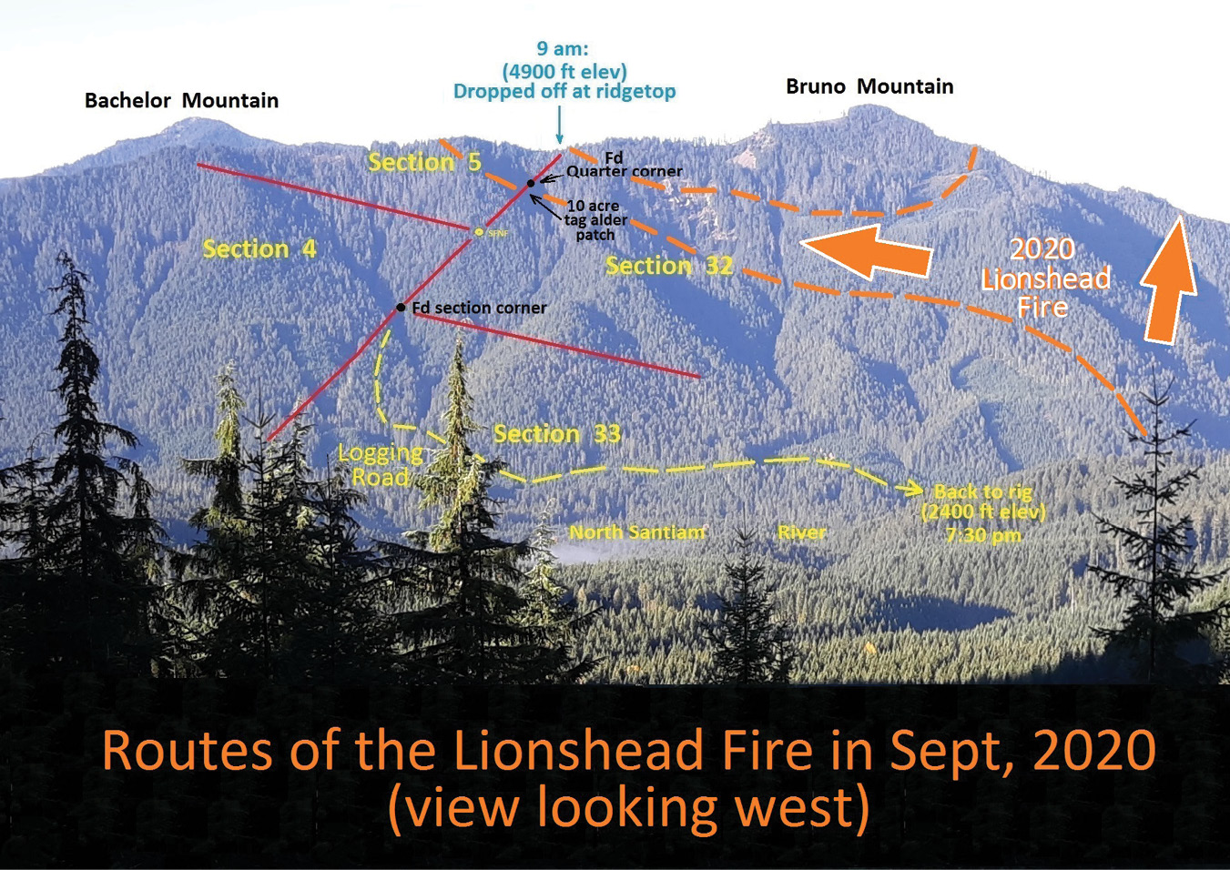
On September 9th, we pulled up to the ridgetop, and to my surprise found that everything north of the top of the hill had been burned by the Lionshead Forest Fire in September of 2020. That fire, of about 100,000 acres, was started by lightning in mid-August on the Warm Springs Indian Reservation, near the crest of the Cascades, and 9 miles from where we were now standing. It had languished there for several weeks while it crawled westerly into the Mt. Jefferson Wilderness Area.
 Several days later, the east winds, not uncommon later in the fall, rapidly developed into an 80 to 90 mph “sustained blowtorch”, the small fire “blew up” and raced west the afternoon of Labor Day weekend. About 3 days later, the winds finally eased and the fire stalled, but not until it had joined with another lightning caused fire, the Beachie Creek Fire. Together, they burned over 200,000 acres of fine timber, 1300 structures, and resulted in 5 deaths, as well as destroying homes and businesses in the towns of Idanha, Detroit, Gates, Mill City, and Mehama, all along the North Santiam River.
Bruno Mountain, a 5000 ft timbered peak, acted like a cleaver and carved out a portion of the south edge of the firestorm and deflected it south to the ridgetop where we now stood.
It was a good news-bad news situation in that the underbrush and old snags, including line trees, had burned completely up, and the standing timber was now all dead and black.
We could look down that 100 percent slope all the way to the two line trees found in 2019 that were 220 feet uphill from the quarter corner. The bark on the north side of them was severely burned (since the winds were pushing this part of the fire south), but the south “half” of them was not scorched. After taking some pictures, we dropped down past the ledge and continued our “semi-controlled fall” 225 feet to the South Quarter Corner of Section 32.
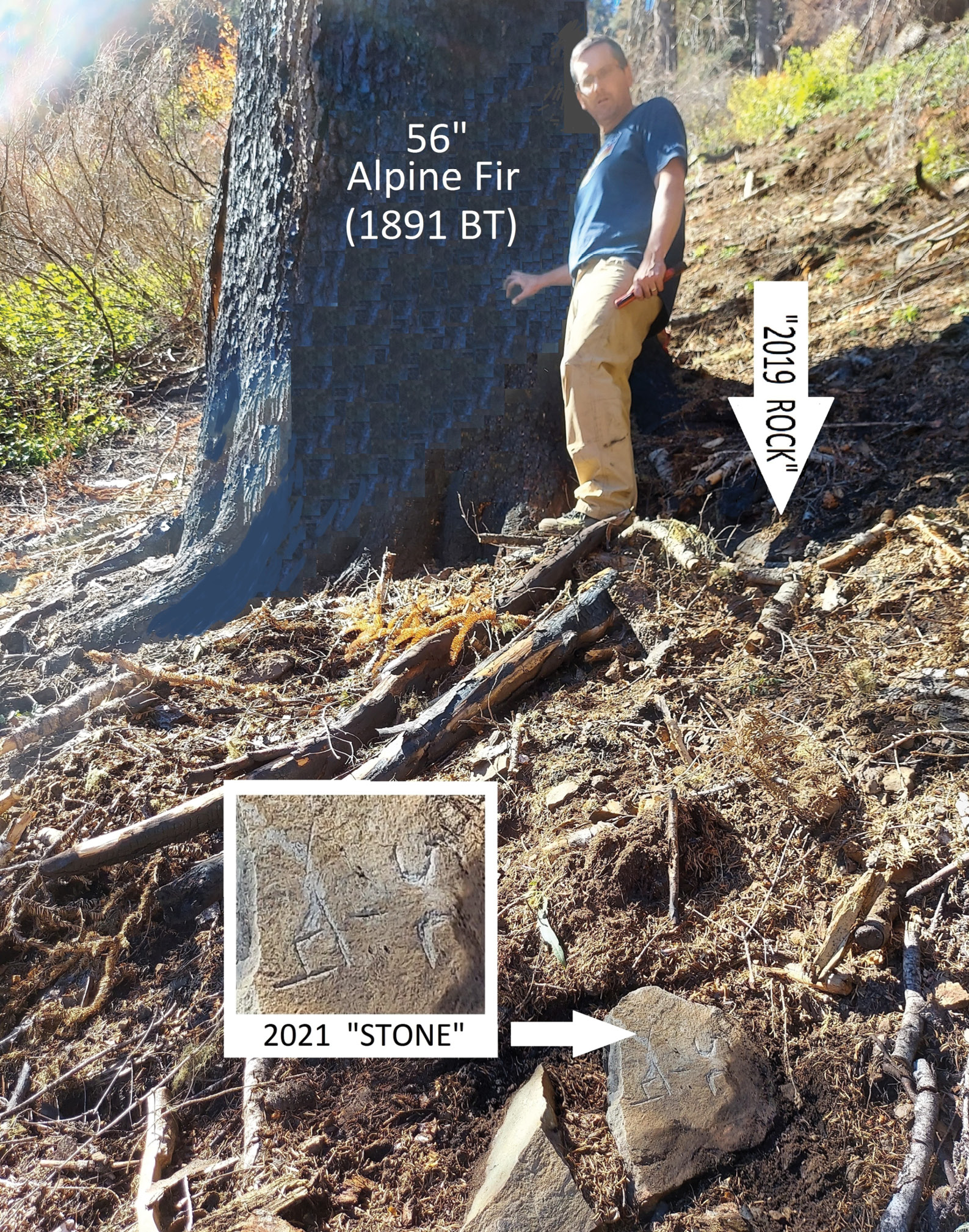
Both BTs were still standing, but were burned and dead, all the way to the crowns. Upon closer inspection, I noticed that the only reason a few tags and remnants thereof were still on the BTs was because I use galvanized nails instead of aluminum ones which just melt.
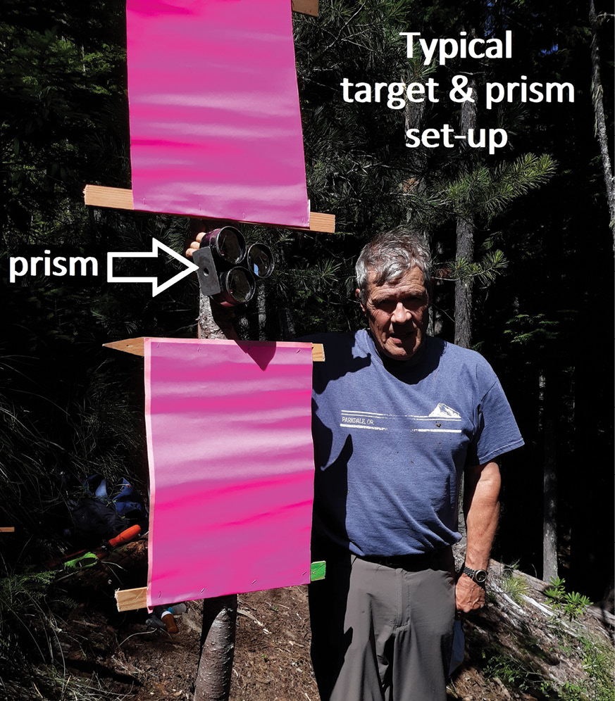
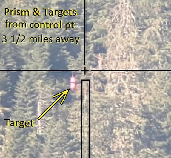
In 2019, I had screwed four horizontal laths onto the northeast side of the southern BT and stapled 2 florescent paper targets (24” vert x 16” hz) to the BT, leaving a one-foot gap between them. I then screwed a “surplus” triple prism in the gap. (In 2021, the only thing left of the “targets and prism” was one torx head screw!) I aimed the prism at a small 10 acre clear-cut 2 ½ miles to the northeast. I then recorded a compass bearing to the “clear-cut” and a vertical angle.
When I finally found that small clear-cut a few weeks later, the compass bearing and vertical angle gave me a pretty good idea where the target was. (This had to be done in the morning with the sun at my back. If I waited till afternoon, I’d be looking into the sun and the targets would be in the dark shade.) After pointing my trusty old T-16 (with a “DI-1000” mounted on top) to the compass bearing and setting in the vertical angle, I could then turn on the DI-1000 and pan left and right till I got a hint of a signal return in the window. Then it was only a matter of adjusting up and down and side to side with the tangent screws till the signal strength was finally “peaked” and a look through the scope revealed the targets.
I had learned this “technique” back in the 60s when the “state of the art” distance meter at that time was a “Tellurometer”, which used micro-wave technology. To measure a distance, it took two people and two identical MRA3 units, one in ”master” mode and the other in “slave” mode, each with an operator. Each instrument weighed about 40 lbs. If you recorded compass bearings and “verts” ahead of time, you could measure in the rain, if necessary, with 1 mile or 20 miles of clouds or fog between units. Each operator had a headset and could talk back and forth with the other. The first distance was determined as the “master” filled out his note form. Then the roles were reversed and the former “slave” switched over to “master mode” and determined the distance from his end. Prior to the measurements, you had to “max” the signal strength and this was done by loosening the 5/8” bolt under the tripod head and manually rotating the 40 lb unit until the needle showing the signal return was “peaked”.
Measuring from the center of each BT, we found the “rock” I had placed there 2 years before. I was standing at that “2019 rock” when something caught my eye. It was a stone about 10 feet down the hill below me. The sun was at a low angle to the south, but its rays were just grazing across the face of the stone and I could see marks plainly as they were “shadowed.” I “slid” down to it and immediately saw the letters “SC ¼” on Campbell’s original stone that had also been cracked open by the heat of the burning duff and limbs. It then occurred to me that I should add another “tale” to the initial 2019 one since now the “real stone” had finally been recovered!
For some reason, I recalled a book titled “Twice Told Tales.” When I was in about the 4th or 5th grade, my older sister and I used to play a card game called “Authors”. It was kind of like “Go Fish” only you asked for book titles instead of numbered playing cards. We played it so much that I knew most of the famous authors and their classic books but have never read any of them to this day. The renowned author Nathaniel Hawthorn, (1804-1864), was mainly known for “House of the Seven Gables” and “The Scarlet Letter”. In 1837 he had written a book called “Twice Told Tales” which was actually a collection of some of his previously published short stories. I thought it proper to give this dissertation that same name, since the developing plot was similar to Paul Harvey’s “The Rest of the Story” programs that many of we older surveyors remember. This particular tale now has a happy ending! ◾
This article appeared in the January/February 2022 edition of “The Oregon Surveyor,” a publication of the Professional Land Surveyors of Oregon.
C.E.“Chuck” Whitten graduated from Santiam High School in Mill City, OR in 1963. He then went to Oregon State University and graduated in Forest Engineering in 1967 and then was hired by the Washington Department of Natural Resources from 1967 to 1972, working on road location and surveying for timber sales. From 1972 until retirement in 2009, he was a project manager and vice-president for Hagedorn, Inc., a private surveying/engineering firm in Vancouver, WA. Since then, he has enjoyed retracing original GLO surveys. In June, 2021 he was hired by the Marion County Surveyor in Salem, OR to recover section corner evidence in 6 townships devastated by the Beachie Creek and Lionshead Forest Fires of 2020.