Trimble 4D Control Adds Support for the Trimble SX Series Scanning Total Station and Trimble Access Software; Integrates Vibration and Weather Sensors Creating a Comprehensive Monitoring Solution
 Sunnyvale, Calif., Dec. 15, 2021—Trimble (NASDAQ: TRMB) introduced today the latest version of its core geospatial automated monitoring software—Trimble® 4D Control™ version 6.3. The software provides automated movement detection to enable informed decisions about infrastructure for surveying, construction and monitoring professionals. Version 6.3 adds new capabilities for the software to work in combination with the Trimble SX Series Scanning Total Stations’ advanced imaging and measurement capabilities. This version also supports industry-leading vibration and weather station sensors and a streamlined workflow between the Trimble Access™ Monitoring Module in the field with the new T4D Access Edition used in the office.
Enhancements made to Trimble’s core geospatial monitoring software provide increased accuracy; simplified sensor data collection, reporting and alarms; and make it possible to seamlessly move from semi-automated to fully automated monitoring on a project.
Superior Accuracy and Image Quality
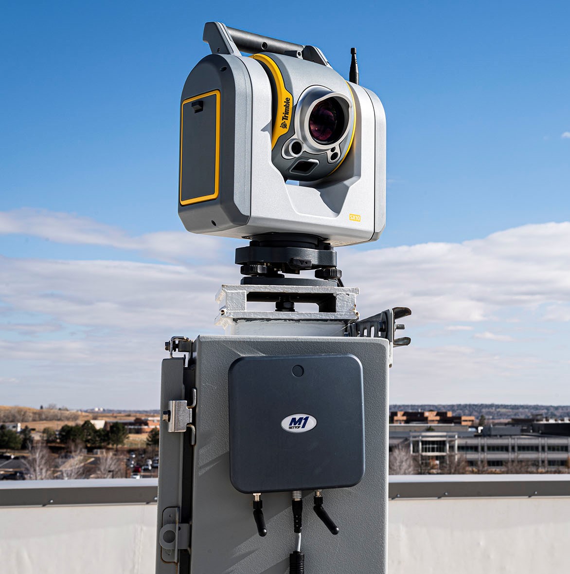
 Integrating with the Trimble SX Series Scanning Total Station, T4D users benefit from Trimble VISION™ imaging technology and high-accuracy Lightning 3DM™ technology for more accurate measurements, enabling a more dense target placement on linear corridors such as rail tracks, tunnels, roads and bridges. A live video feed makes it possible to better understand site conditions, manage target placement remotely and capture images for use with T4D visual inspection capabilities. These images can be compared over time and viewed next to the displacement or movement charts. This enables users to identify the potential cause of displacement and record movement changes over time.
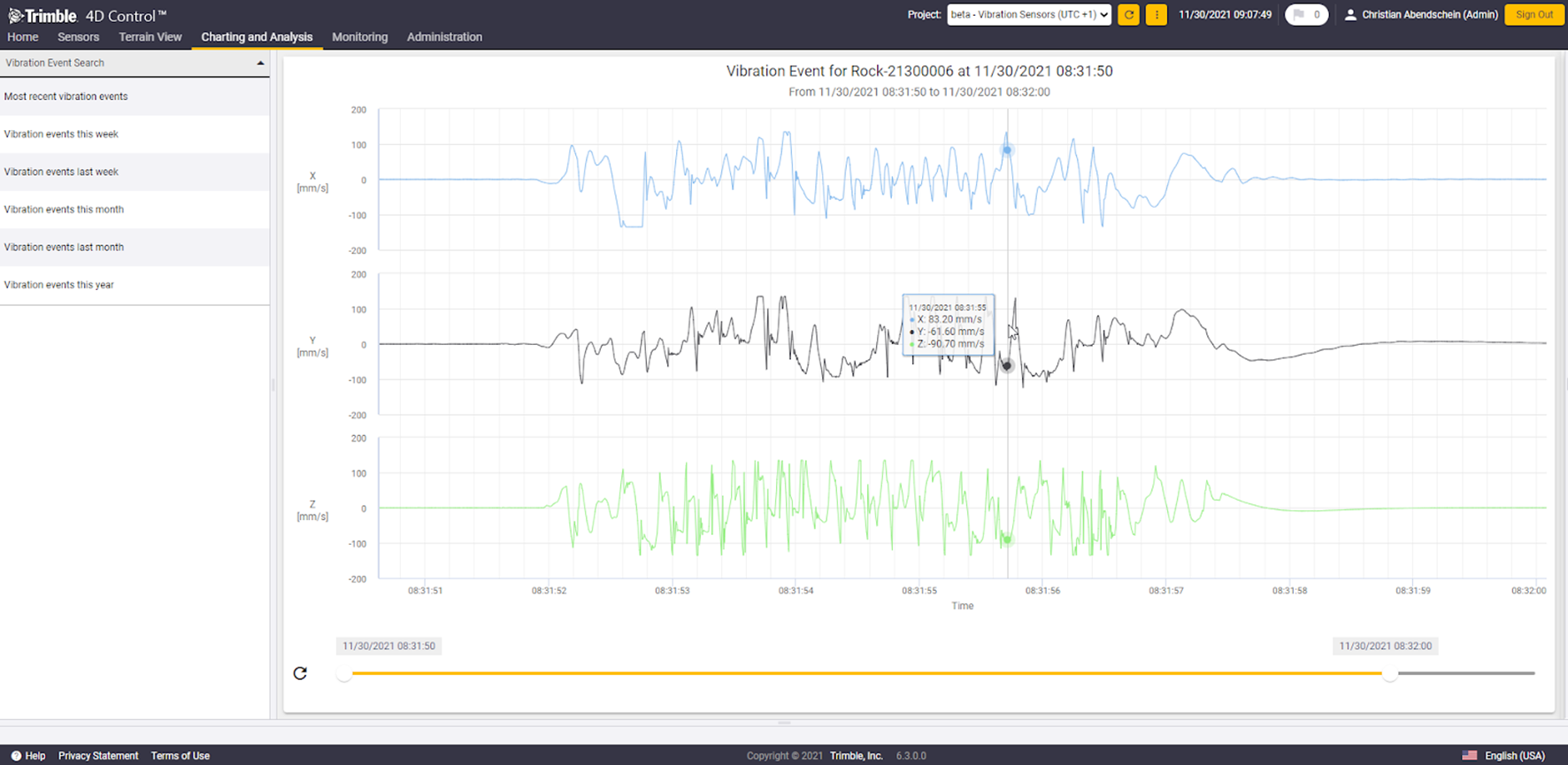
Sensor Integration for Complete Data and Increased Confidence
Users can now integrate industry-leading solutions from Syscom and Vaisala with T4D version 6.3. Vibration sensors from Syscom allow surveying, civil and geotechnical engineers to easily combine geodetic and geotechnical information supporting high frequency and event-based vibration information. This data is often used for mandatory reporting on civil and infrastructure projects. Integration with the Vaisala weather station enables users to analyze the impact of environmental conditions such as temperature, rainfall, wind and atmospheric pressure in combination with other geospatial and geotechnical monitoring information, which is useful for slope stability analysis in mining, landslide and dam monitoring operations.
Ease of Transition from Semi- to Fully Automated Monitoring
With the introduction of the new T4D Access Edition, customers can now benefit from the automated, seamless transfer of field data from the Trimble Access Monitoring Module to the T4D Access software in the office. This enables users to scale monitoring operations from a semi-automated to fully automated monitoring system while maintaining the continuity of historical data in the same charts and reports.
“By integrating T4D with the Trimble SX Series Scanning Total Stations and Trimble Access Monitoring Module, we are providing customers access to a wider Trimble solution set for monitoring applications,” said Boris Skopljak, business area director of Monitoring and Tunneling, Trimble Geospatial. “We are also continuing to expand support for additional sensors such as Syscom’s vibration sensor and Vaisala’s weather station. This enables our customers to leverage an even more comprehensive, turn-key solution.”
Availability
The new version of T4D Control is available now. For more information visit: https://monitoring.trimble.com/blog/latest-releases-trimble-monitoring.
About Trimble Geospatial
Trimble Geospatial provides solutions that facilitate high-quality, productive workflows and information exchange, driving value for a global and diverse customer base of surveyors, engineering and GIS service companies, governments, utilities and transportation authorities. Trimble’s innovative technologies include integrated sensors, field applications, real-time communications and office software for processing, modeling and data analytics. Using Trimble solutions, organizations can capture the most accurate spatial data and transform it into intelligence to deliver increased productivity and improved decision-making. Whether enabling more efficient use of natural resources or enhancing the performance and lifecycle of civil infrastructure, timely and reliable geospatial information is at the core of Trimble’s solutions to transform the way work is done. For more information, visit: https://geospatial.trimble.com.
About Trimble
Trimble is an industrial technology company transforming the way the world works by delivering solutions that enable our customers to thrive. Core technologies in positioning, modeling, connectivity and data analytics connect the digital and physical worlds to improve productivity, quality, safety, transparency and sustainability. From purpose-built products to enterprise lifecycle solutions, Trimble is transforming industries such as agriculture, construction, geospatial and transportation. For more information about Trimble (NASDAQ: TRMB), visit: www.trimble.com.
