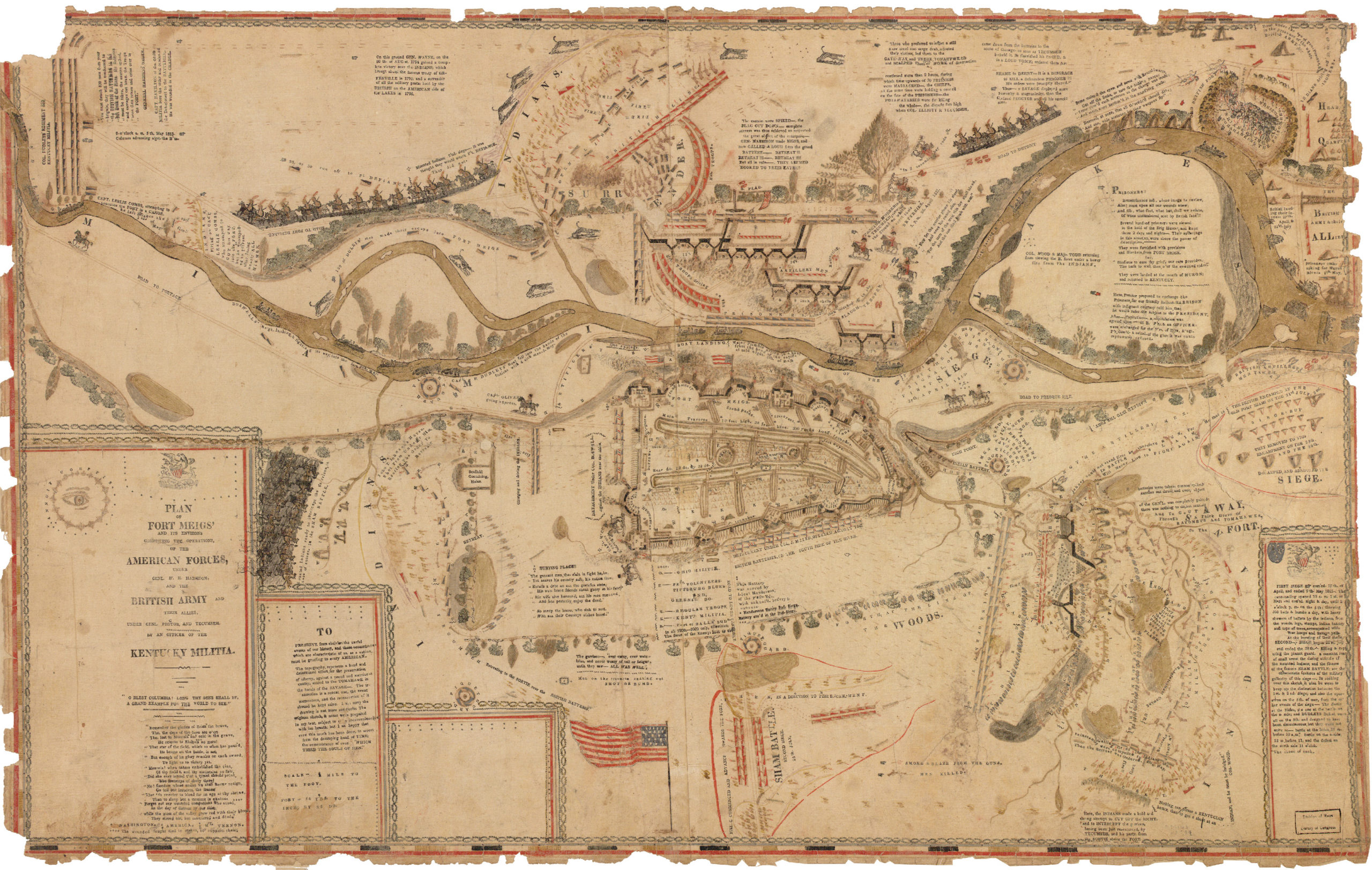
1813 “Plan of Fort Meigs’ and its environs…” by William Sebree. Courtesy of the Library of Congress.
The annual Rendezvous for the 2021 Surveyors Historical Society (SHS) was held in Perrysburg, Ohio between September 22-25. Not only is Perrysburg an iconic landmark in Northwest Ohio, but it is also home to Fort Meigs. Almost directly centered on the Twelve Mile Square Reservation (originally centered on Fort Miami across the river), the Fort played a major role in the War of 1812. Unfortunately, with that title comes loss as the fort also holds the remains of over eight hundred interred soldiers, only some of where the locations are known. With the combination of the SHS and our newly acquired Ground Penetrating Radar (GPR) Unit at the University of Akron Surveying & Mapping Program, the opportunity was taken to scan the grounds for unmarked graves while gaining some positive media attention at the same time.
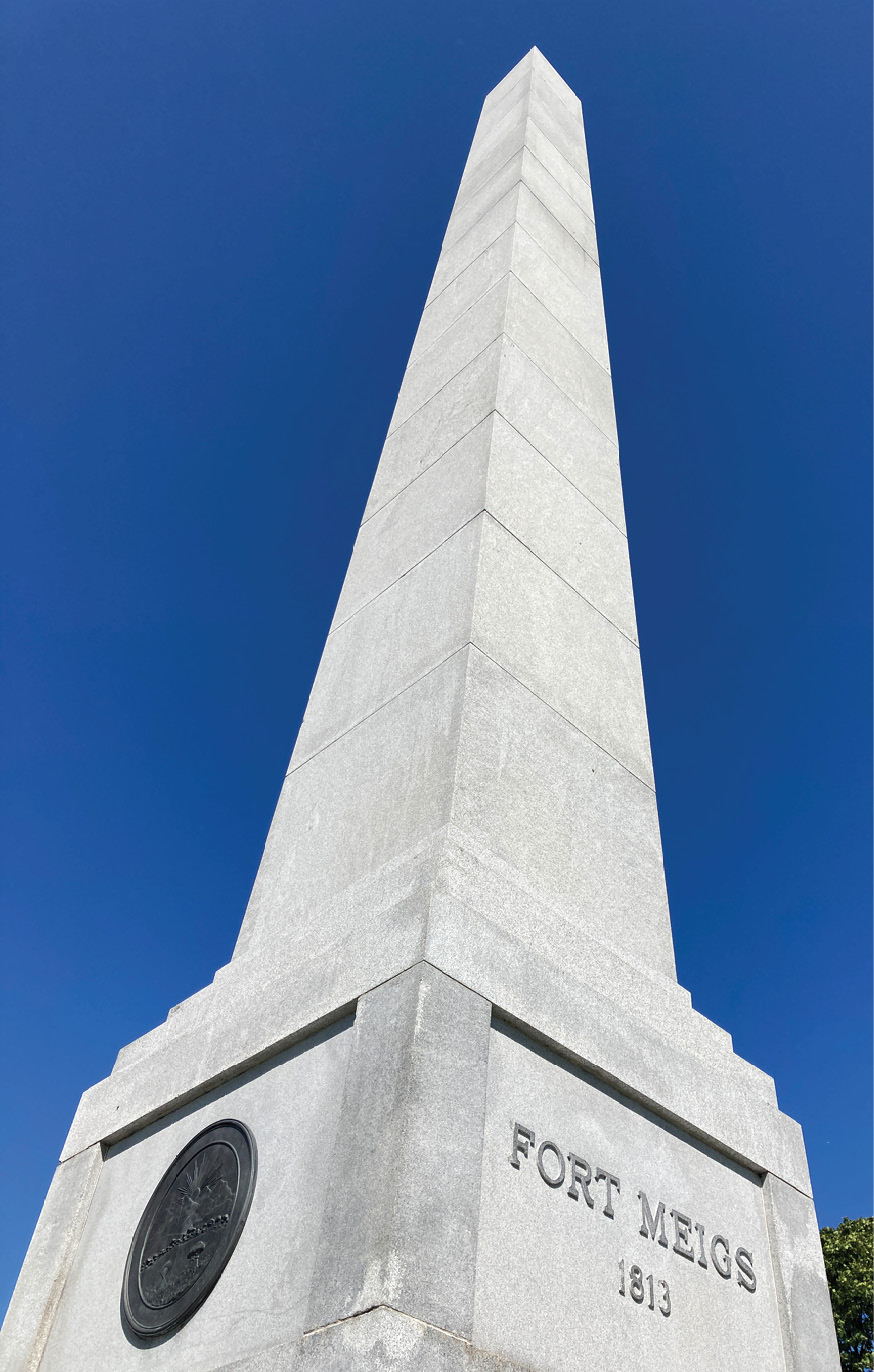
Granite obelisk at Fort Meigs by Lloyd Brothers of Toledo, Ohio. Photo courtesy of the author.
The War of 1812 is often considered the second war of independence. The British were trying to restrict our trade and a young America was looking at expansion. The Native Americans were unsettled after the 1811 Battle of Tippecanoe and the Shawnee Chief Tecumseh joined with the British to prevent further territorial expansion. America went on the defensive and signed a declaration of war on June 18th and immediately attacked Canada. Soon thereafter British Sir Isaac Brock, Tecumseh, and his Natives, defeated and took control of Detroit—the then Territorial Capitol of Michigan. When battles continued South it was Fort Meigs who stood strong under multiple sieges and then the pivotal battle of Lake Erie as led by Commodore Oliver Hazard Perry turned the tides. Unfortunately, the White House was burnt before the Treaty of Ghent was signed ending the War. Those who attended the Rendezvous had the option to go to Put in Bay on South Bass Island and feel the spray of water and think about those critical moments in our history.
The original construction of Fort Meigs started in February of 1813 and was completed a couple of months later in April. The first major siege soon thereafter took a toll of almost 600 men but still ended in a victory. The second siege in July, of the same year, was more of tomfoolery by the Natives than a real battle. The mischief didn’t work and of all things a thunderstorm drew the British and the Natives away. As the enemy retreated North the fort was torn down and rebuilt as a supply depot. After the end of the War the depot was then abandoned and then once again torn down. Similar to Fort Michilimackinac and Fort Mackinac farther North in Michigan, the forts were later completely rebuilt and today stand as living history museums.
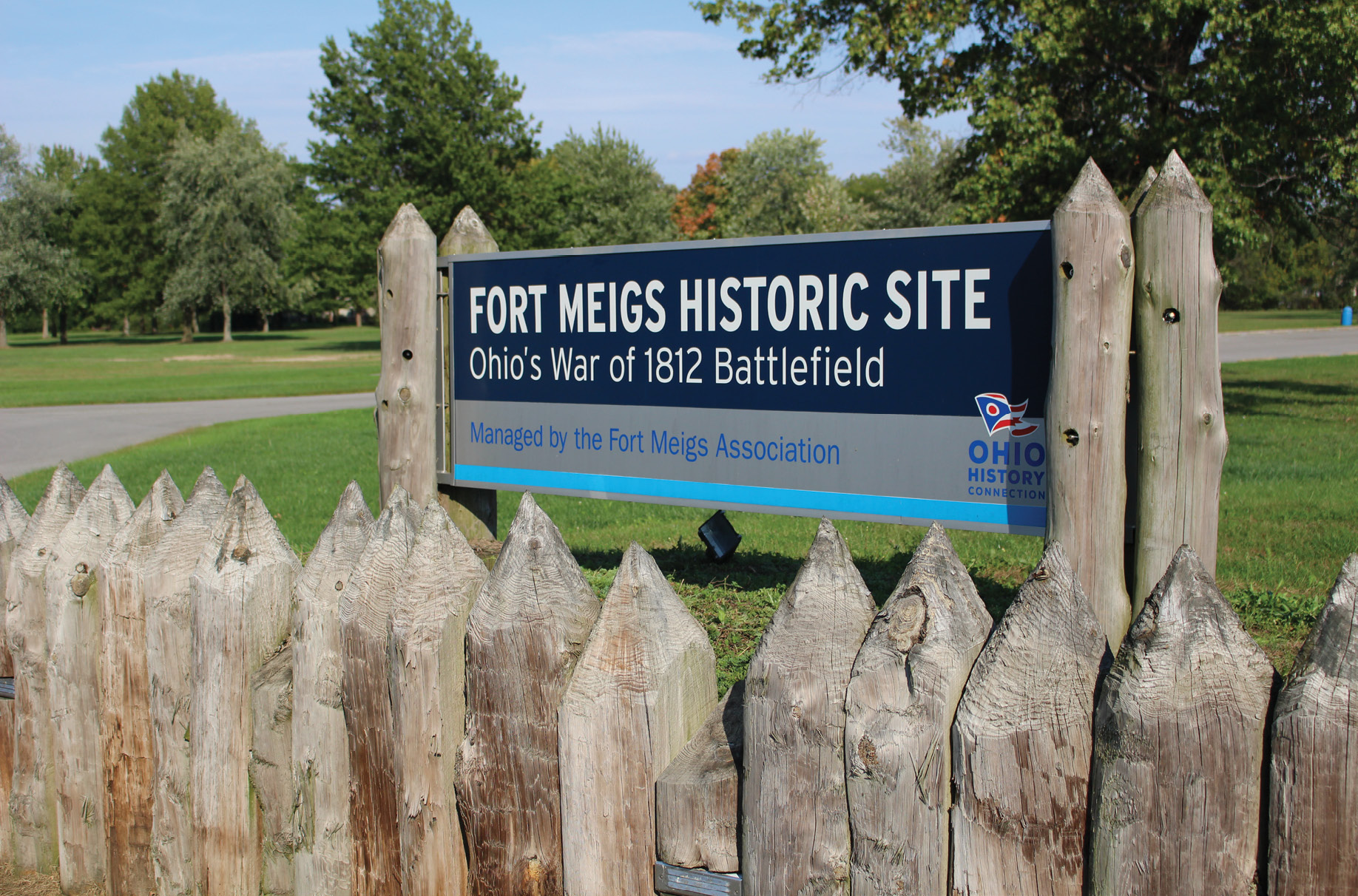
The entrance to Fort Meigs in Perrysburg, Ohio. Photo courtesy of the author.
In 1908 the 81 feet, 8-inch granite obelisk was constructed at a cost of $14,000 to memorialize, commemorate and preserve Fort Meigs forever. According to the literature for the dedication, the monument “…is symbolic of the patriotic spirit of the people of today and their deep and lasting love and gratitude for the hardy men of 1812-1813”. Ironically, the monument was constructed by Lloyd Brothers, the same company who held the contract for the nearby granite Michigan/Ohio State Line boundary monuments. A 6.2-million-dollar renovation, started in 2000, reconstructed the forts blockhouses, constructed the 14,000 square foot Museum and Education Center and funded other much needed improvements. The fort employs five full time employees and is under the guidance of the Ohio History Connection. Even today though, the estimated 825 soldiers in various unmarked mass graves continue to be searched for—and on this September day GPR would be the search tool.
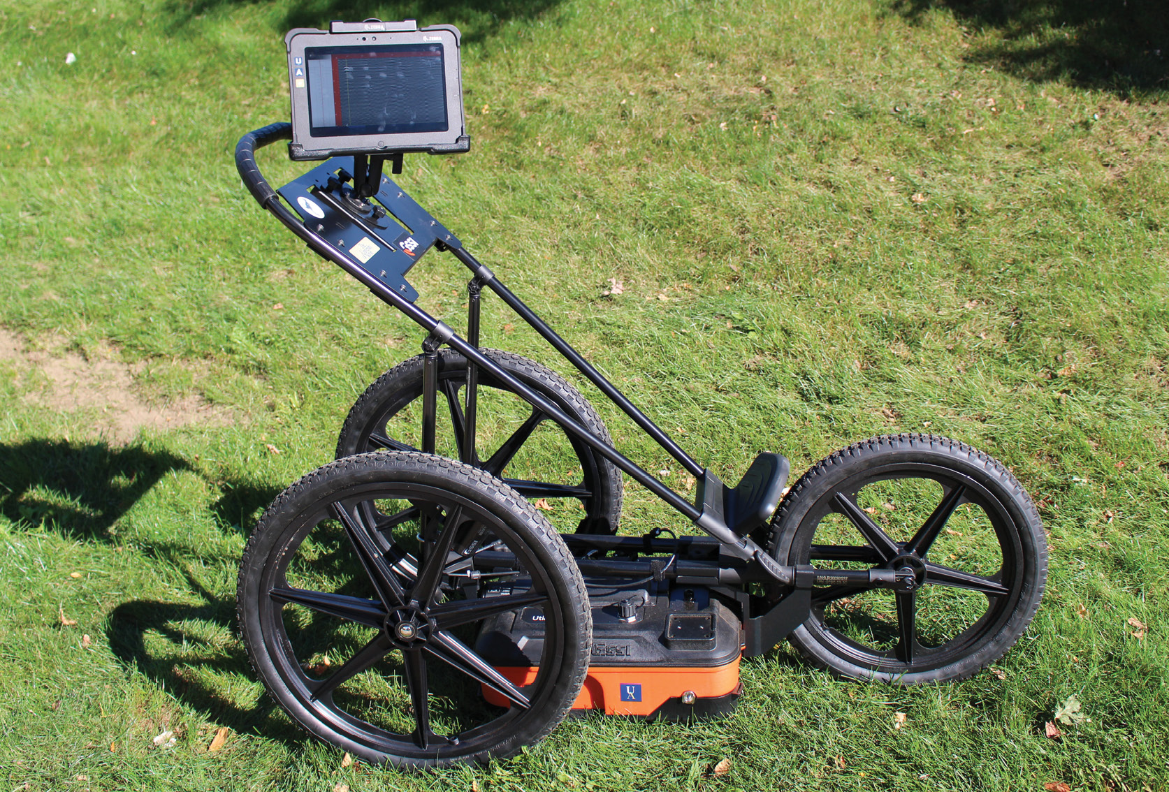 GPR is an amazing instrument, completely harmless and non-invasive. According to Geophysical Survey Systems Incorporated (GSSI), the technology “…works by sending a tiny pulse of energy into a material and recording the strength and the time required for the return of any reflected signal. A series of pulses over a single area make up what is called a scan.” These are high frequency electromagnetic waves passing through the ground. I often explain GPR as “…a sophisticated and super expensive fish finder. But while a fish finder uses sonar (sound navigation and ranging based on acoustic waves), GPR uses radar (radio detection and ranging) ….” The most challenging part of running a GPR scan is estimating the dielectric constant. The scale for dielectric ranges from 1 to 81 with 1 being the constant for air and 81 being the constant for water. GPR signals work very well in clean dry sand and very poorly in heavy wet clay. When I did my scan at Fort Meigs the ground was completely saturated in heavy clay and my dielectric constant was calibrated at 50.80 to get a decent scan, and even that was very shallow.
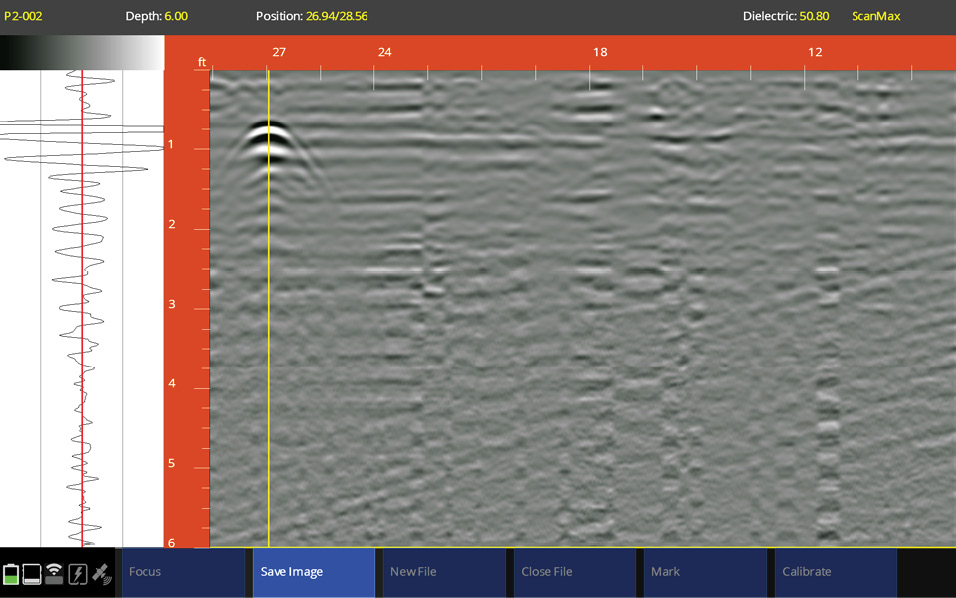
A screen shot of of the UtilityScan in the ScanMax Data Collection Mode showing the oscilloscope and the associated anomaly.
The results on the screen do not show up like they portray in Hollywood. You can’t see the outline of a gun, or a skull, or bones on the screen. What you see is a hyperbola, an open curve with two branches. This hyperbola is the reflection off a material and is defined in the GPR world as an anomaly. Depending what you are searching for this anomaly might be an isolated object, linear object, or a void—all showing different results on the screen. The true talent of using GPR is being able to read the scans and interpret what lies beneath the surface. GPR has many applications beyond SUE and surveying. The most common application is scanning concrete with a fist sized 2600 MHz High Resolution Antenna. This is used for locating conduit, rebar, and post tension cables and only scans about 12 inches deep. The much larger 100 MHz Antenna would be pulled behind a utility vehicle and can scan depths up to 100 feet in the right conditions. This unit would be best suited for geotechnical and environmental applications. The most average, most multi versed antenna fall in the 270—900 MHz range.
The Surveying & Mapping Program at UA wrote a requisition for a GPR unit in late 2020 to use in Boundary Surveying, Topographic Surveying (Subsurface Utility Engineering) and to collaborate with Civil Engineering and Geosciences. After researching various vendors, the choice of GSSI was a simple one. We chose the UtilityScan 350 MHz unit. This system works well for SUE as well as the search for stone survey monuments. The GPR technology itself has not changed that much since the 1980s but the associated controller component and software sure has.
The software, from GSSI, now gives you the ability to see the oscilloscope, gain and focus your scans, but most importantly calibrate the dielectric with programming technology called Hyperbolic Shape Analysis or Migration. This has always been a guessing game with the various soil types and fill materials, but GSSI has made this feature one of the best I have ever seen. GSSI is the world leader in GPR technology, where they research, design, build and train in their award-winning facility in Nashua, NH. The training was a big selling point, as they play you through multiple scenarios for two days both in the classroom and in the field running and interpreting scans. By the end of the training, we met new friends around the Country and felt confident in our ability to run the equipment. We also left a few pounds heavier as they catered lunch to our liking.
The combination of the SHS and the GPR at Fort Meigs grabbed the local media’s attention. It gave us an outlet to explain what the rendezvous was all about, explain what GPR does, but most importantly explain what land surveyors do every day. Although technically we don’t look for unmarked graves every day, we do scan the subsurface for survey monuments and utilities. Tony Geftos from 13abc in Toledo was very interested in the technology and interviewed us multiple times throughout the day. He is a 2-time Emmy award winning journalist and has over seven thousand followers on his Tony Geftos TV Facebook Page helping to spread the word.
We are collaborating with the Ohio Department of Transportation and the State of Michigan for their remonumentation programs. We are building case studies to bring into the classroom to help educate and train our students, so they also feel comfortable using GPR equipment, consequently building up their resumes and making themselves more marketable.
Although the weather was picture perfect, the soil underneath was heavy and saturated. The GPR scans were mostly inconclusive, but the search for interred soldiers drew much needed, encouraging, media attention for the Rendezvous and the surveying profession in general. We will continue to build solid case studies of GPR technology and with any luck turn a strange looking hyperbola on the screen, an anomaly in the ground, into a “lost” survey section corner stone. A stone that has always been there, but now located and not calculated with modern technology and wrongly proportioned. As always, some of the best tools in our truck are the shovel, spud bar, and in rhythmical fashion, GPR.