Are drones for land missions here to stay?
 The unmanned aerial solutions often referred specifically to drones are becoming more common in land operations – mapping, surveying and inspection for the land development. The technologies have rapidly developed and now time-consuming tasks can be carried out efficiently and safely by a drone. Rapid technological development has also made drone tech more accessible in aspect of price.
Land inspection and development requires an accurate map and in-depth knowledge of the land. In order to get detailed and reliable maps and surveys, increasing number of developers are using and relying on drone-based solutions reducing operation time and team size in comparison with ground-based methods.
 The most common drone equipment for land mapping and surveying missions includes high resolution RGB photo camera, 3D scanners or LiDAR sensors. The equipped drone can replace conventional ground-based methods, which is particularly important in challenging areas such as swamps, thick plantation or protected areas that are not allowed for transport and heavy machinery.
The other benefit brought by air method is the reduction of risk for humans. Specialists are no longer required to handle operations on dangerous or hazardous sites as drone operator can execute mission from a safe distance.
The drones can serve in surveying, mapping, monitoring the objects or land sectors and allow analysis for quality decision making. Let’s look at several diverse cases where drones substantially contribute.
Aerial Photography on Elbrus
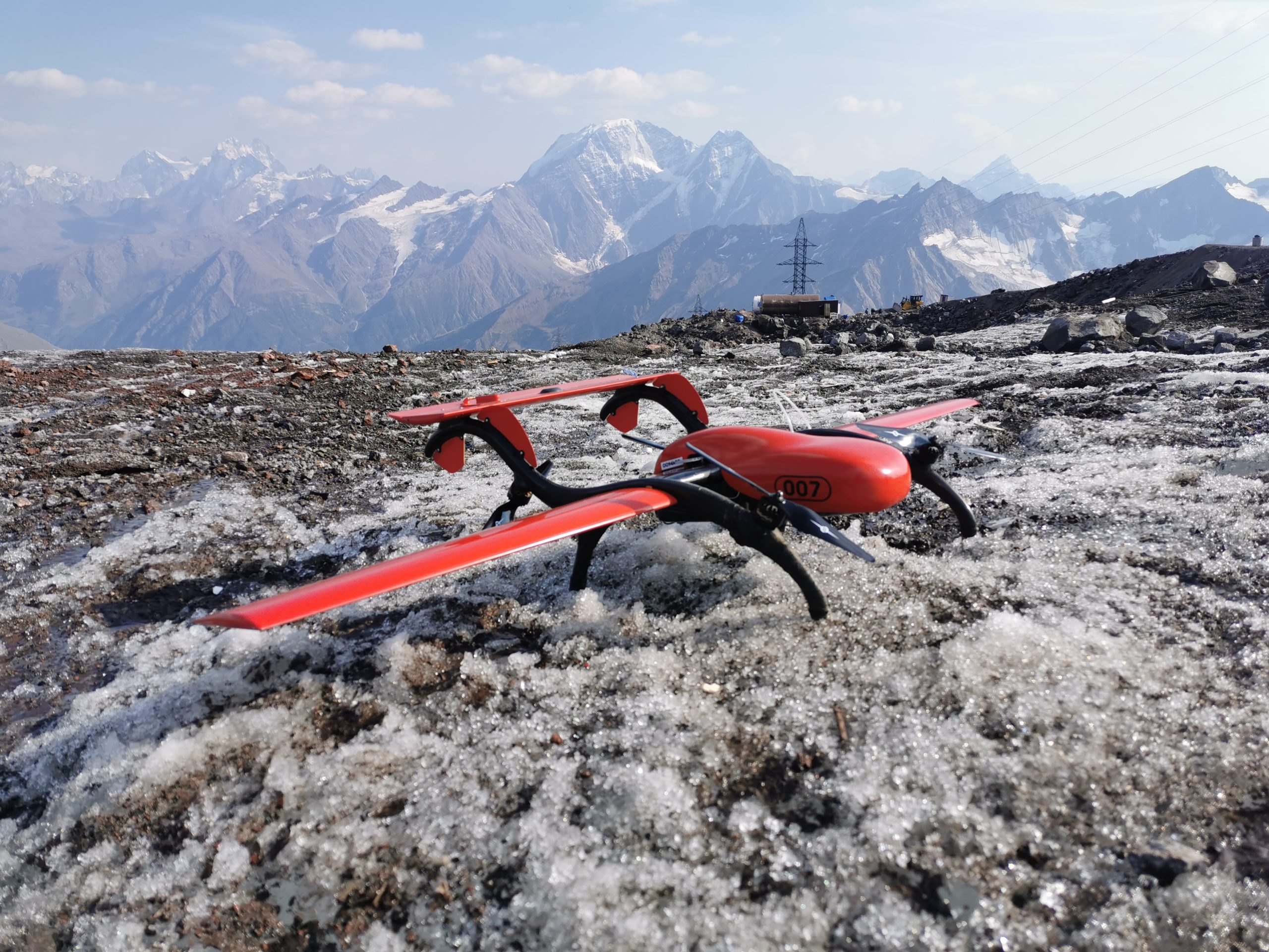 Mountains are one of the challenging areas to execute mapping and surveying, this is where drones step in. In this case aerial photography was used. Still, flights over mountainous regions are unpredictable due to rapid changes in weather and the thin air, sharp altitude differences require fine-configuration of the flight plan to achieve the required resolution of the images, accurate vertical landing is mandatory, as landing with a parachute is most likely to lead to the loss of the aircraft: wind drift, inability to locate the device in mountainous terrain.
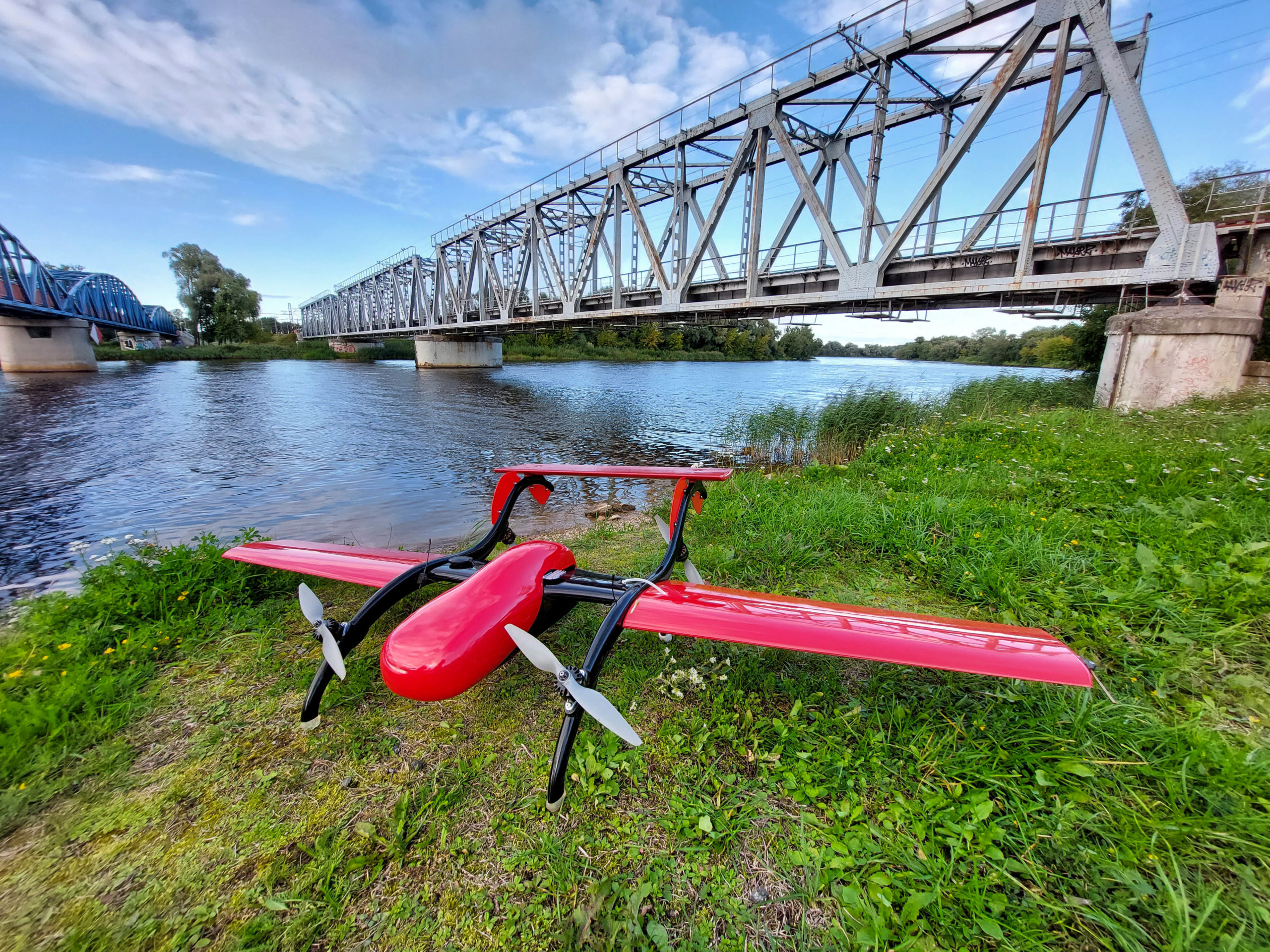
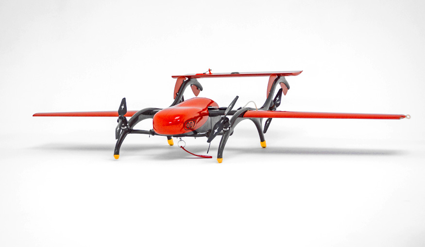
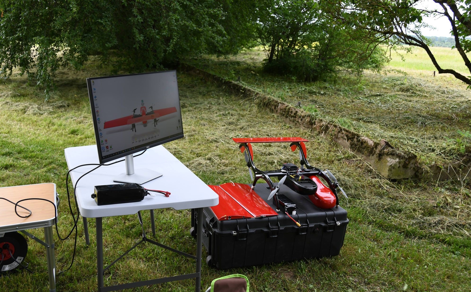
To solve these challenges FIXAR 007 equipped with RGB camera was used. FIXAR 007 aerodynamic design allows a vertical take-off and landing from/to unprepared areas with accuracy down to 1 meter radius without the need of a catapult for take-off or a parachute for landing, the aircraft is resistant to wind up to 12 m/s. The FIXAR 007 has a specially designed propelling unit for efficient flights at altitudes above 3000 meters, the FIXAR xGroundControl software (xGCS) allowed to load a specified altitude map and set a flight plan.
FIXAR xGCS offers also the possibility to set a minimum safe altitude. Adherence to the rules stated at the pre-brief for building a flight plan in the mountainous terrain ensures safe flights. FIXAR xGCS functionality allows a constant navigation altitude and high-definition images to be collected over any terrain throughout the entire flight. With no magnetometer sensors onboard, FIXAR 007 is fully independent of the magnetic environment and can be operated in the vicinity of reinforced concrete structures, shafts and mines, plus the system is fully autonomous from take-off to landing.
FIXAR team performed aerial photography at an altitude of 4 500 meters above sea level, on the peaks in Mount Elbrus, the highest mountain in Europe. The purpose of the project was to create an accurate map using orthophoto as part of geodesic surveys for the construction of a Cable car in mountainous terrain.
Detailed images of the terrain with a total area of 8.2 km2 were made with a resolution of 5 cm/pixel for a total period of 4 hours, operating a FIXAR 007 with the onboard equipment weight of 1000 grams. In severe weather conditions in high mountainous terrain, high-quality data-set was gathered and later used for the design and construction of the Cable car.
Mapping of Site Boundaries
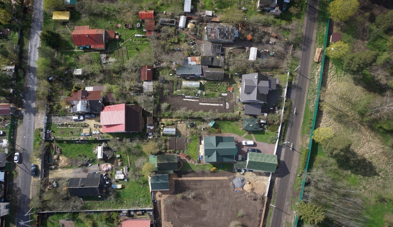 Aerial photography is one of the most efficient and fastest methods of obtaining, studying and presenting objective spatial data for topographic plans, construction monitoring, etc. FIXAR team conducted aerial photography in a cottage settlement over youth sports and health camp. Vertical take-off and landing were carried out from the stadium located in the camp territory. Safety was a major priority and concern and it was ensured during all performed flights over the settlement area.
Aerial photography of the terrain with a total area of 1200 hectares was made with the resolution of 4 cm/pixel for a total of 6 operational hours with the equipment load weighing about 1000 grams on board.
The mission resulted in photographic materials of the required quality, which were subsequently used for cadastral work to map and define the boundaries of land plots in the cottage settlement.
Aerial Photography of a Railway
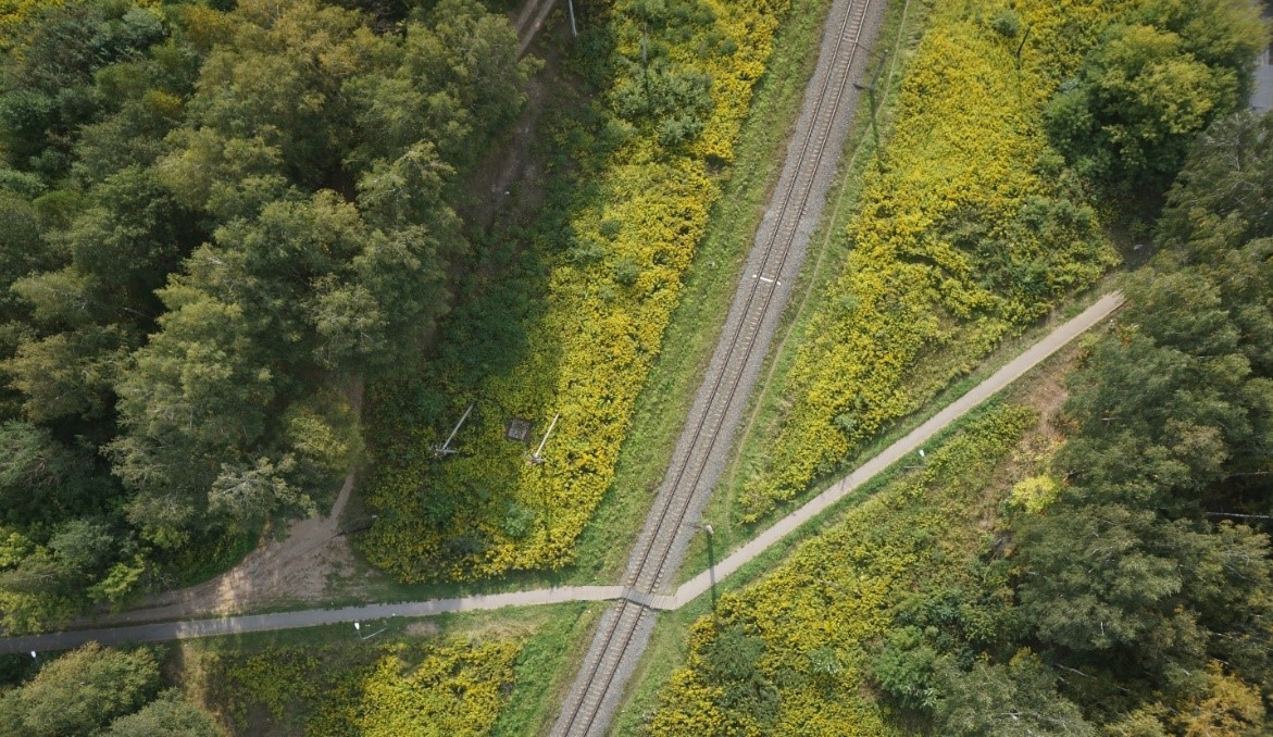 Aerial photography of a long linear object is a complex process that faces many challenges making it fundamental to find the right equipment. For a correct and detailed examination of long and linear objects is required multiple flights in both directions to cover the length of the object to be examined, with some of these flights covering long distances and sometimes under rough weather conditions.
Often loss of the navigation signal from satellites lead to the emergency landing of most RPAS models, resulting in extensive operational downtime but also unnecessary time spent locating the aircraft in remote locations – not to mention the possible total loss of equipment, therefore for this mission FIXAR 007 was used.
The team carried out aerial photography of a railway section to clarify the integrity of the security zone and infrastructure elements around it. The total length of the railway section surveyed with the FIXAR 007 was 32 km, and the width area of the recorded section was about 100 meters. The total time spent with the pre-flight preparation, territory analyses and carried out work was of 6 hours. Flights for photographic and data collection took no more than 2 hours and were performed by several round-trip flights in a line pattern. Images were gathered using a 5 cm/pixel resolution. The used payload weight was 1000 grams.
High-definition photographic materials and data were obtained and subsequently used for a detailed analysis of the railway infrastructure and the security zone along the railroads.
Survey for Land Development
 Specialists from Latvia University of Life Sciences and Technologies (LLU) took full advantage of the FIXAR 007 unmanned aerial system in order to perform a land evaluation for further Vecauce mansion (Latvia) complex and adjacent farm development plans.
As further steps, LLU in cooperation with the local municipality considers the opportunity to leverage the FIXAR technology to test the performance in field conditions as well as to estimate real costs and to determine the pricing of potentially provided services.
“We are looking forward to applying FIXAR drone-based technologies in order to introduce an EU-supported training course for LLU students. We believe that drones like FIXAR 007 can become an integral part of smart farming while refining techniques and practices in real agriculture conditions.” – says Indulis Ievins, Board Member, managing director at LLU mps “Vecauce”, SIA (Latvia University of Life Sciences and Technologies study and research farm “Vecauce” Ltd).
The survey mission was performed using FIXAR 007 aircraft equipped with high-quality RGB camera Sony Alpha A6000 providing output images with 2 cm/px (0.8 in/px) accuracy. The detailed high-quality orthomosaics with 2 cm/px (0.8 in/px) accuracy for further analysis were created.
The survey took 38 minutes during which 58 ha (143 ac) of hilly terrain was covered. Compared to manual work, which usually takes about 2 working days, the FIXAR 007 UAV system made it possible to complete the project 15 times faster.
About FIXAR
FIXAR is a leading software and design developer, powering commercial autonomous UAVs for industrial applications. Founded in 2018 by aerospace engineer Vasily Lukashov, the company holds a unique patented design that is simpler and more reliable than other configurations. The company is present in 20+ countries around the globe and serves more than 40 end-customers through the network of distribution partners.
