The Riparian Boundary—Not Your Usual Boundary
 In the United States, rivers, streams and lakes provide a natural boundary for millions of parcels along thousands of miles of boundary line. As boundaries, rivers are a natural monument, holding the highest priority in the order of conflicting title elements. Visible, their identity certain, they have been used by man as boundaries for millennia. However convenient, and as natural, visible, substantial and inviting as they are for governments, treaties, and owners, they have one huge, troublesome characteristic: They move! There are many other issues related to using waterbodies as boundaries, but their ambulatory nature is what makes riparian boundaries different from all others. This boundary movement, influenced by the whims and vicissitudes of Mother Nature and the designs and construction of man, brings uncertainty. With movement, the extent of title and tract acreage changes; even small differences in fluvial processes can result in large differences in ownership. Landowners face uncertainty in something they desire to be firm and absolute: The location of the boundaries of their real property. Generally, owners do not like their boundaries to change, their acreages decreasing or increasing, their lands perhaps vanishing altogether. These boundaries can change by forces of nature that are not within the riparian’s control. Or one’s riparian boundary may be changed by others without the riparian owner’s knowledge or permission, such as by artificially-induced river movements. Riparian boundaries frequently bring conjecture to the landowner, consternation to the surveyor, confusion to attorneys, confoundment to the courts and they have conflated commentators.

Aerial image illustrates past complex river movements. Today’s boundary position will depend on the area’s fluvial and title history.
Additionally troublesome is that riparian boundaries can be four-dimensional: In a plane, their North/East horizontal position can be affected by vertical movement of the waterbody. And time can affect the riparian/littoral boundary location. (If the river moved slowly or quickly can have an effect.) Four dimensions, very unlike its usual two-dimensional boundary brethren.
And most boundary disputes between adjoiners are personal and are based on emotions. The cost of litigating a boundary almost always far exceeds the value of the land in dispute. Not so in some riparian boundary disputes. At stake can be thousands of acres of land or issues worth tens of millions of dollars. The most epic boundary litigation matter in United States history was a riparian boundary dispute: The famous “Red River Litigation” between Oklahoma and Texas. That litigation spent the 1920s in and out of the U.S. Supreme Court and even at this date there remains an ongoing kerfuffle concerning the boundary. Another example is the current “Is it a river or is it a lake” question in Lake Catahoula in Louisiana (with huge ownership and other consequences).
Lex Aquae
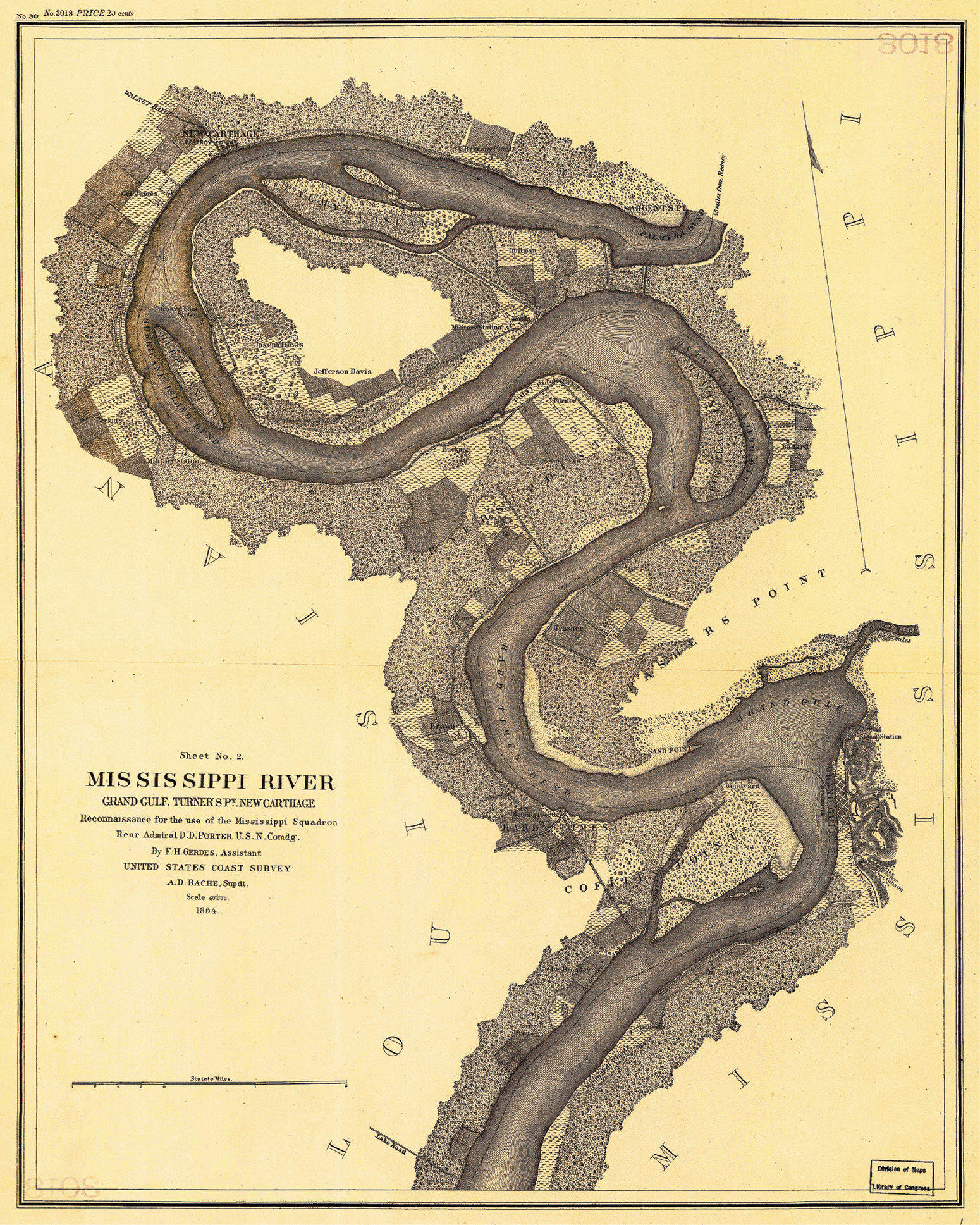
Mississippi River, Grand Gulf, Turner’s Pt., New Carthage Reconnaissance for the use of the Mississippi Squadron; Gerdes, F. H.—United States Coast Survey; 1864 Courtesy Library of Congress
With its foundation in English Common Law, courts and legislatures (both state and federal) have proclaimed “lex aquae,” the law of the water. Riparian (river) and littoral (lake or seashore) boundaries are part of that law. Riparian boundary law is complex, largely buried in court decisions that set precedents, and, like the shifting sands in a river, it has and will continue to evolve. But it establishes the rules and principles to be followed by the Professional Surveyor when determining the location of a riparian boundary.
Boundary control legal principles are fairly uniform nationwide, hence there are books by Skelton, Clark, Brown, Robillard, Wilson and others that do a good job of stating and explaining them. Some legal principles are broadly applicable nationwide. The general riparian rules for erosion, accretion and avulsion are examples and they are adequately covered by the authors listed above. Under the Equal Footing Doctrine, the federal government left most riparian issues to the states (while reserving federal interests). Because states can (and have) developed their own law and rules relative to water law and riparian boundaries, there are differences. Some riparian boundary issues are very state-specific. One doesn’t have to dig too deeply into riparian boundary subjects to find rules that are very different state-to-state: If a state owns the bed of a river that is navigable for title (not all states do), what is the title boundary between the state and the upland owner? If you said Ordinary High Water Line, you’d be correct for less than half the states. So, books by the authors listed above don’t delve too deeply into riparian boundaries…as they shouldn’t.
Some Examples
To illustrate how state-specific some riparian/littoral boundary issues can be, here are some questions or hypothetical situations. For your jurisdiction, state the applicable legal principle, along with any qualifying statements or explanations necessary. No answers are supplied with this quiz because there is not one answer that will be correct for all 50 states and federal lands. One or two will be close to the same nationwide, but even they will need a qualifying note or two.
If you’ve not accomplished many surveys of riparian tracts, you may not have thought of or encountered some of these circumstances. All of these issues have been before the courts. It is likely these issues are settled for your state. (Perhaps not to the specificity desired by the Professional Surveyor, but the general principle can be stated.)
- For a non-navigable stream, what line is the boundary between opposite landowners? Define, exactly, that line and how it is located.
- Who owns the bed of a waterbody that is navigable for title? Is it the State in trust for the public? Is it the upland landowner but subject to an easement in the public for commerce and recreation? Or is it in some other entity?
- Suppose the bed of a river is navigable for title and is owned by the State. Where is the boundary between the State and the upland owner? Define, exactly, that line and how is it located.
- Who owns an island that forms in a navigable river?
- On a navigable river that has barge and commercial traffic, for the states on opposite sides of the river, where is the state boundary? Define, exactly, that line, and how is it located.
- Suppose a non-navigable lake that was meandered by the GLO slowly goes dry. The littoral owners hire you to survey their lakebed ownership. First, do these upland littoral owners have any rights in the now dry lakebed? Describe how you proceed.
- Suppose that post-avulsion on a navigable river, there’s a cutoff lake, formed from the abandoned channel. The cutoff lake partially fills in. Who owns the bed of this cutoff lake?
- Owner A conveys to B “all lands north of the river,” then Owner A conveys to C, “all lands south of the north bank of the river.” Based on those facts what is C’s northerly title line?
- For your state, are the legal principles different for a river as compared to a lake? If so, define or distinguish the difference between a river and a lake.
- The GLO meander line is practically never the upland owner’s boundary. As the successor to the patentee, the patent being a lot made fractional by a waterbody, the waterbody is the boundary, not the meander line. Can there be an exception, the meander line being the boundary?
- Suppose in the deed of a riparian tract, its acreage is given. A current survey shows that the acreage mentioned does not include the accretions to the tract that have been added since the deed was written (but has been used in subsequent conveyances for many years). Are the accretions conveyed by the later deeds?
- Does your jurisdiction embrace or reject re-emergence? That is, suppose that by erosion an advancing river completely erodes and washes away a parcel. The river then retreats, accretions forming where the parcel formerly was located. Who gets title to the “re-emerged” parcel? Does the original owner’s title “re-emerge,” or, does title accrete and inure to the benefit of the owner of the last mainland the river touched (who could have been previously non-riparian)?
- On a stream that is non-navigable for title (the upland owner(s) holding title to the bed) does the public have the right to float-fish or canoe through the property? Camp on its banks?
- Suppose artificial improvements to the banks or in the channel of a river create changes downstream by erosion and accretion. Do the usual legal principles of riparian boundaries still apply?
- When does the apportionment of an accretion stop, the apportionment becoming fixed? That is, as an accretion grows and changes shape its apportioned lines move as well. When do those lines become fixed?
- Is there a difference between navigability for title and regulatory navigability? Is there a nexus between the two? Who decides if a river is navigable for title? Who decides regulatory navigability?
- Is, or can there be a difference between federal navigability and state navigability? Can a river be navigable for title under the state test, but non-navigable under the federal test? Can the state test and federal test be different?
- Is the river adjoining the tract you are surveying navigable or non-navigable for title? How do you know? Will it make a difference in the survey? Yes! For your state, who determines if a river is navigable for title? [By the way, is there a difference between navigability for title and regulatory navigability? The answer is yes. I know of no state where they are identical. But, in riparian boundaries, statements such as this are dangerous. It seems there is always an exception.]
Note that these questions/situations are focused on inland, nontidal rivers and lakes. Just as many questions could be posed for tidal boundaries.
The Challenge
Each state needs its own manual that addresses its riparian and littoral boundary location principles. Coastal states should include its tidal boundaries. To accomplish this, all riparian/littoral decisions related to boundaries need to be discovered, indexed by topic, read, abstracted, then summarized. With these summaries and aided by learned articles on the subjects, publications and statutes, the legal principles can be stated. The product will be a book on riparian/littoral boundaries specific to the jurisdiction. This has been done for only one state, Arkansas. See “Riparian Boundaries for Arkansas” by the author of this article. Pages: 288. Tables: 30. Figures: 12. Within that book, the answers for each question given above can be found.
To start your state’s manual, for the questions/circumstances in the examples given above, do the case law and statute law research necessary to state the legal principle or provide guidance on the matter, specific for your jurisdiction. Cite the applicable decisions and summarize them. Once this is accomplished for each state and the federal lands, someone with high professional knowledge of and experience with riparian/littoral boundaries and who is an excellent writer with lots of energy and unlimited time and resources can edit the resulting tome about inland, nontidal riparian and littoral boundaries and coastal tidal boundaries. It would be a herculean task. That’s why no one has done this to date.
This “challenge” is made somewhat in jest, but posing the questions/situations is not. They illustrate how complex riparian boundaries can be, and how statespecific they can be.