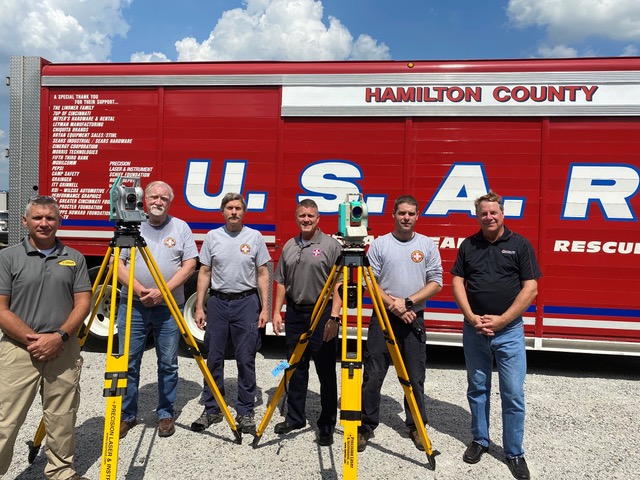
 Cincinnati, Ohio, October 11, 2021 – Spectra Geospatial and Precision Laser & Instrument (PLI), a Spectra Geospatial authorized distributor, have enabled the all-volunteer Hamilton County Urban Search and Rescue (US&R) to significantly upgrade its search and rescue capabilities. The two companies recently teamed to donate two Nikon reflectorless total stations that will permit the US&R to improve safety by enabling remote monitoring of a structure’s movement in its potential collapse zone without the need to have personnel enter the building to place retroreflectors on the surface of the building.
Serving portions of southern Ohio, Indiana and northern Kentucky, the mission of the Hamilton County US&R is to respond to disaster sites, man-made or natural, to safely rescue those in danger, search for the missing, recover those who have been lost and mitigate major property loss.
According to Collin Grove, rescue specialist, and Pat Aungst, structures specialist, the Nikon total stations, an XF-2 and a NPL322, will be used to remotely monitor structure movement in potential collapse zones, including compromised structures adjacent, for example, to a collapsed trench during a rescue operation. The requirements are for a 5” accuracy – an eighth-of-an-inch at 500 feet – and to record and save side shot measurements, including possible movement over time, allow for easy relocation of the instrument by calculating its location from saved reference points using resection and measure/display 3D coordinates of any point in a user-defined coordinate system. The Nikon total stations also enable the team to obtain distance measurements for possible rigging and crane operations that would otherwise be difficult to acquire accurately by other means.
To date, the two total stations have been used for training sessions. “The training sessions have confirmed their tremendous value to the team. We expect them to help us work more safely in future incidents,” said Grove.
About Precision Laser & Instrument
Precision Laser & Instrument, Inc., headquartered in Ambridge, PA, is an authorized distribution partner of Spectra Geospatial equipment. With locations in Pennsylvania, West Virginia and Ohio, the company provides comprehensive positioning solutions for the construction, survey, and GIS industries.
About the Nikon NPL-322+
The Nikon NPL-322+ Series of mechanical total stations includes a 2”-dual face and a 5”-single face model. Both NPL-322+ models feature dual axis compensation to correct for errors in tilt in the horizontal and vertical axes, a reflectorless EDM with 400-meter (1300 feet) range, wireless Bluetooth connections to external data collectors, and 50,000-point onboard storage.
About the Nikon XF-2
The Nikon XF mechanical total station is packed with features that make survey work easier and faster. The superior Nikon optics give crisp, bright sightings even in low light conditions. The Nikon XF portfolio gives the opportunity to choose the electronic distance measuring (EDM) technology that works best for the type of work being performed.
About Nikon-Trimble
Designed to meet the needs of surveyors around the world, Nikon delivers maximum precision, reliability and affordability. Located in Japan, Nikon-Trimble Co., Ltd. is a joint venture between Nikon Corporation and Trimble to address the global surveying and construction markets. In Japan, the company focuses on the design and manufacture of surveying instruments, including mechanical total stations and related products. Outside Japan, Trimble and its subsidiaries are the exclusive distributors of Nikon survey and construction products.
About Spectra Geospatial
Spectra Geospatial is an established brand known for delivering quality products to the survey, GIS and construction markets. Focusing on the specific needs of the conventional surveying market, the Spectra Geospatial brand offers a complete product portfolio, including Global Navigation Satellite Systems (GNSS), optical total stations, data collection hardware, field and office software, as well as a wide range of construction tools. Spectra Geospatial surveying equipment is an economical choice that utilizes advanced technologies for optimal efficiency. With convenience and reliability as the foundation of the Spectra Geospatial brand, it is an ideal choice for value. The Spectra Geospatial brand is backed with the strong technical support that users have come to expect from a quality name in surveying and construction.
