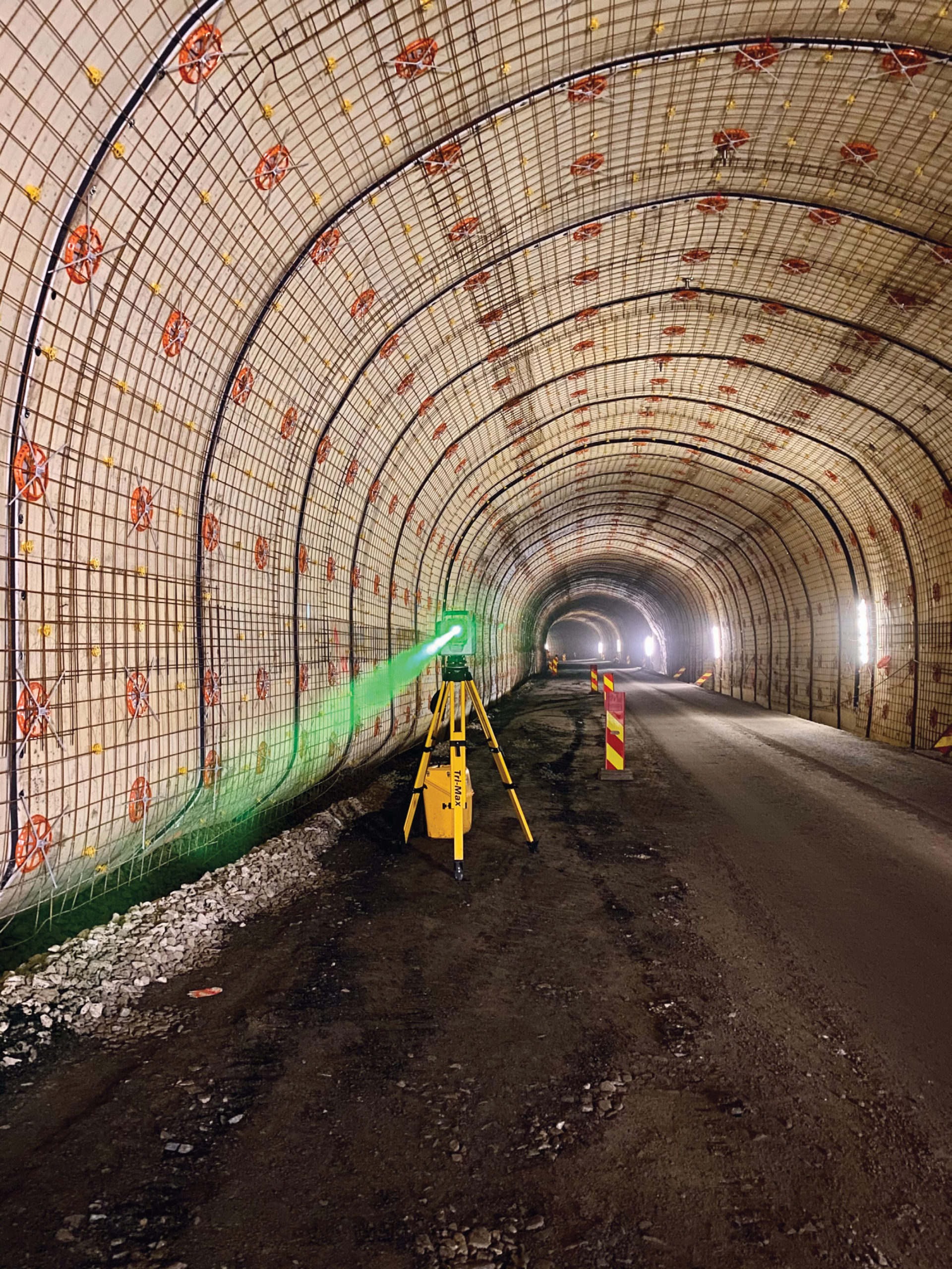
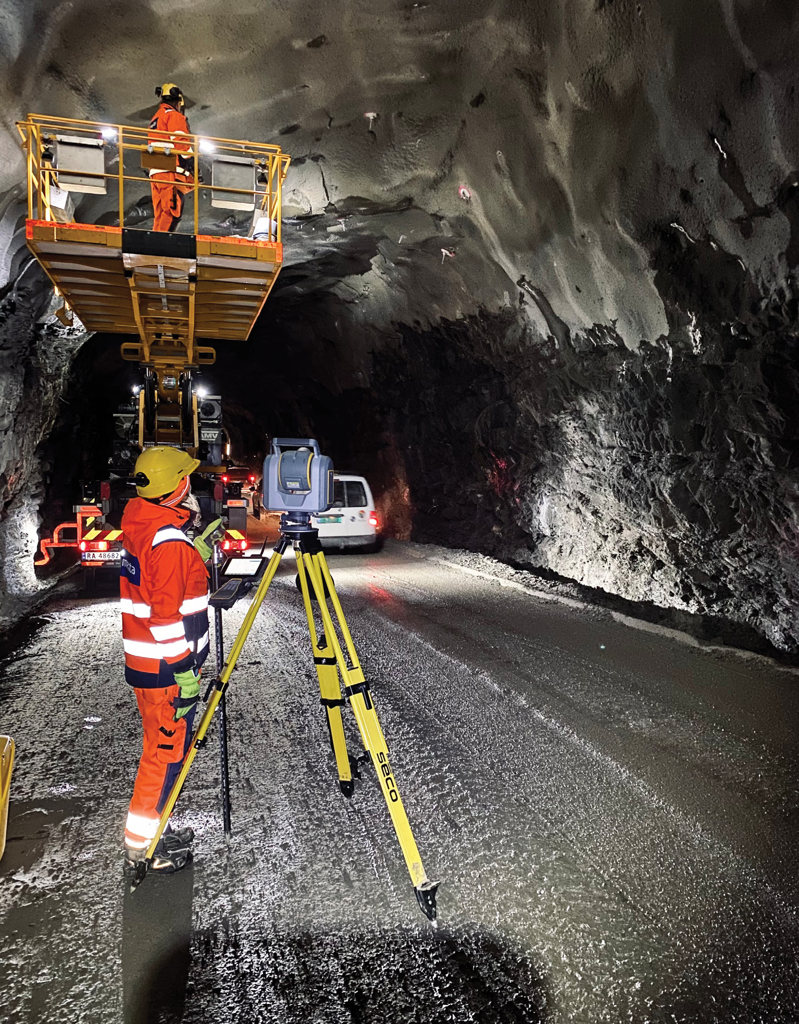
The SX12’s green laser shines brightly in the Maursund tunnel. On the walls are reinforcement materials. The red discs with cross bars are the bolts that hold the mats on and the steel grid is for extra reinforcement. Concrete will then be sprayed onto the the steel grid.
When professional surveyor Sylvia De Vuyst arrived in the northern edges of Norway in March 2021 for a significant tunnelling project, she wasn’t sure what to expect. Freshly hired as the tunnel surveying manager for Mesta, a civil engineering construction company based in Lysaker, Norway, De Vuyst would be the lone surveyor responsible for the NOK $211 million (US $24.8 million) renovation of the Maursund and Kågen Tunnels, two critical passageways that connect the cities of Nordreisa on the mainland and Skjervøy on Kågen island.
Each about 2 kilometers long, the Maursund Tunnel (Maursund) travels under the North Sea, reaching a depth of −92.5 meters (−303 ft) below sea level and a 10-percent grade in some areas; the Kågen passes through Kågen mountain, which is vulnerable to avalanches and landslides. Built in 1991, both structures will undergo extensive upgrades including widening their carriageways, installing new LED lighting, Co / No2 gas meters, new water and frost protection, and new drainage systems, and building new road surfaces.
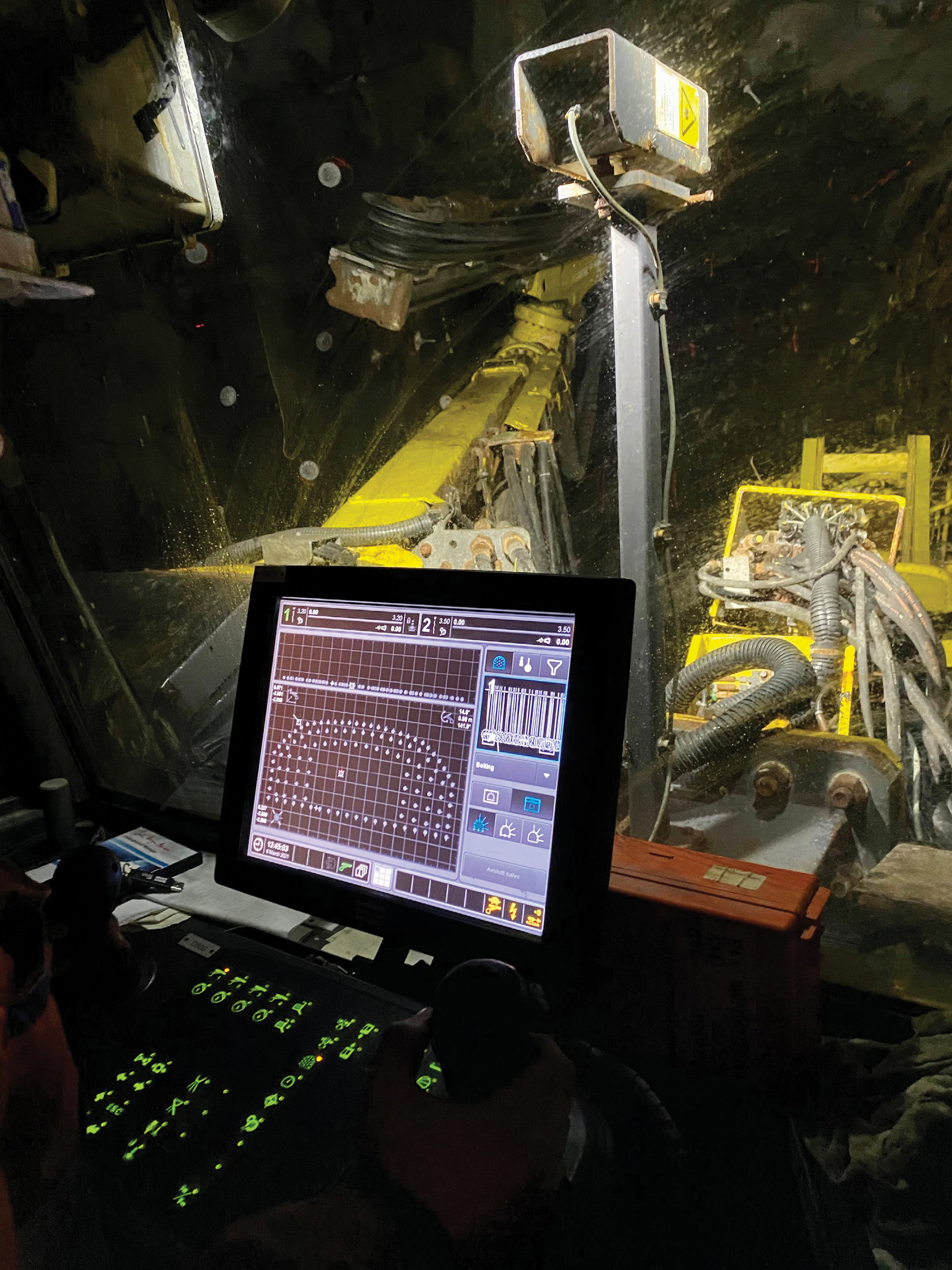
Drilling out space for Maursund’s technical building. On the rig’s screen the operator can see the driving box to help guide the drilling.
After one week in the dark, damp tunnels, one project requirement became abundantly clear to De Vuyst: she’d need to be agile.
“A major challenge with the Maursund is that it needs to stay open 24/7 to allow traffic to pass through at set times,” says De Vuyst. “This means that many times a day the diggers and bolt riggers need to move to the side, big trucks need to drive out and sometimes I need to stop my survey work. So when we’re clear to work, we have to maximize our productivity. To ensure construction stays on target and pace, I need to be efficient, reliable and precise.”
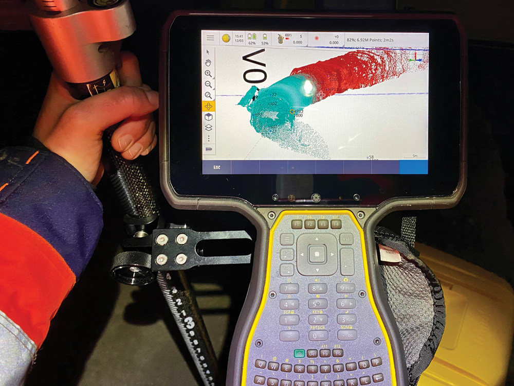
Viewing two scans on the TSC7. The smoother green scan captures a section of the Maursund where reinforcement materials have been installed. The rougher red one doesn’t yet have reinforcements installed.
Instead of using the traditional total station—the typical domain of tunnel surveys—De Vuyst opted to replace convention with a scanning total station. Combining the high accuracy total station point measurement with the speed and precision of 3D scanning, De Vuyst is managing two tunnel environments where tolerances are tight, space is at a premium, visibility is low and expectations are high—on her own. And she’s matching the frenetic pace of the digging, blasting and bolting at six times the speed of multiple-person crews.
Change in plan
Tunnel surveying is a specific breed of project that requires unique techniques and skill sets. It’s challenging to create and manage a geodetic control network, operate in a GNSS-restricted environment and maintain high accuracy over a long, linear distance underground. It also requires a solid understanding of geodesy to anticipate how the vertical alignment of the tunnel is affected over its length.
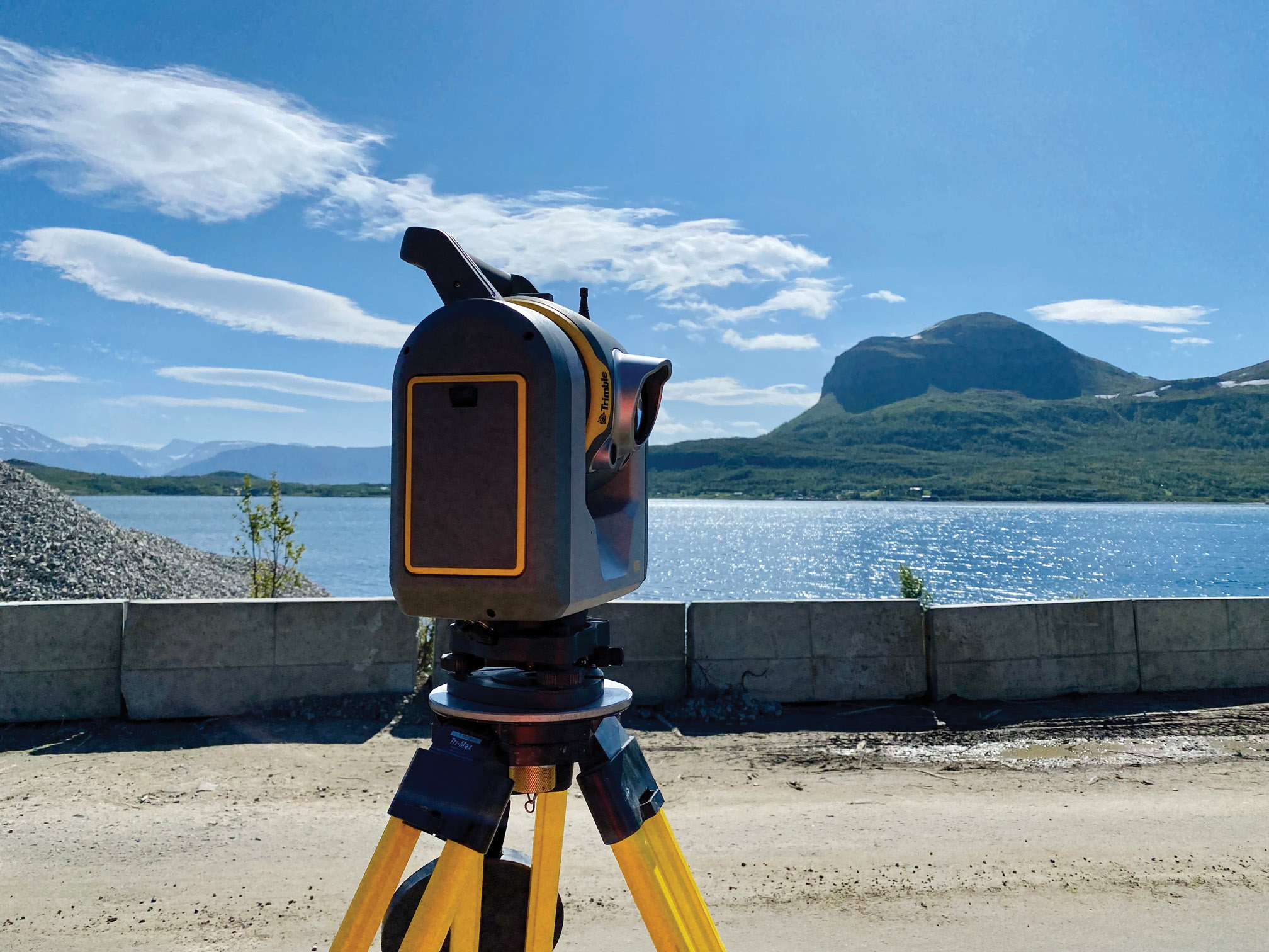
The SX12 outside the Maursund tunnel.
Not only do the Maursund and Kågen tunnels have these general complexities, they have multiple layers of challenges in addition to the 24/7 traffic flow issue. Neither one has been designed with a pre-defined shape, making it more difficult to guide construction. All the rock material that is extracted is immediately reused by other firms so there isn’t the option to measure stocks and calculate volumes. None of the machinery—save one grader with a Trimble SCS900—is equipped with machine control. And in the Maursund tunnel, a technical building, measuring 5.4-m wide, 4-m high and 19-m long, needed to be constructed and assembled into a confined space with a tolerance of 0.5 m.
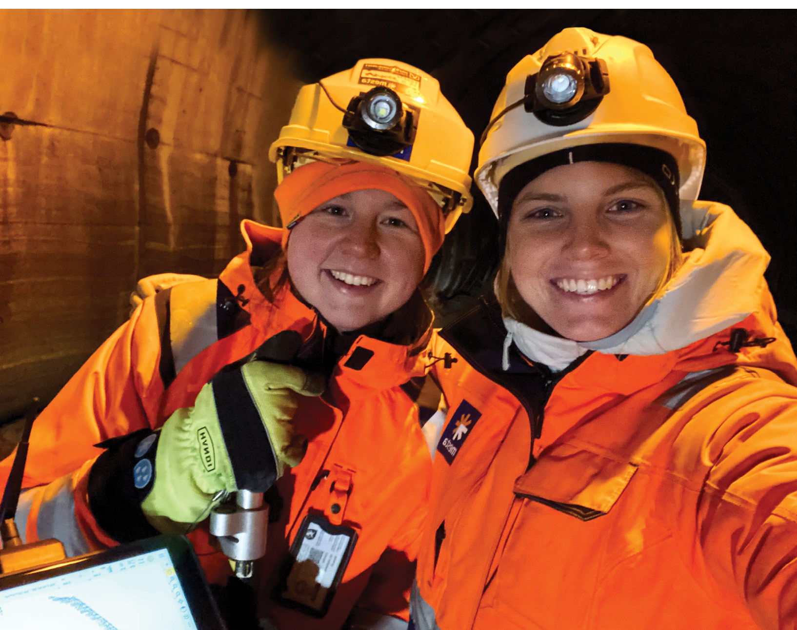
The all-female survey team. Sylvia De Vuyst (right) and her trainee Sofie Kolsum.
When the renovation first began in January 2021, the original plan was to run one, two-person survey team with a total station and occasional scanning, and they would alternate every week. However, given the scale, setting and project deadlines, this approach proved problematic within the first two months of work.
“Measuring and establishing control for the carriageway—one of the most essential jobs to ensure we create the required width and height—with a total station requires constant setting up, measuring and setting out, which is quite time consuming,” says De Vuyst. “So in order to keep up, they had to be on site every day and night taking measurements. Laser scanning is far more efficient. With my scanning total station, I can scan 500 meters to measure control at a precision of .005 meters in four hours; that would take the total station team two days. That efficiency has not only enabled me to manage all surveying tasks by myself, it’s allowed me to limit my time on site to only four days every other week, saving us survey costs and positively impacting the project’s budget.”
De Vuyst uses the SX12 to set out ventilation bolts.
The scanning total station that De Vuyst is referring to is the Trimble SX12, a total station and scanner combination that is particularly well suited for underground projects like tunnels. It can scan a full dome at 100 m with a point density of 0.1 m in 11 minutes, lock onto a prism in five seconds, and pinpoint a 3-mm diameter spot at 50 m with its green, eye-safe laser pointer.
“We chose the SX12 based on extensive demos we received on it as well as our experience with previous Trimble SX models,” explains De Vuyst. “The combination of surveying and scanning technology makes it incredibly versatile—I can perform multiple functions from the same set up. It’s fast and precise which is important for such a dynamic environment. With its ease of use, short learning curve, simple and intuitive functionality and seamless workflow integration, I felt I would be in good hands with the SX12 for my first project with Mesta,”
Based on progress to date, it seems the SX12 and the surveying tasks have been in good hands with De Vuyst.
Where are we
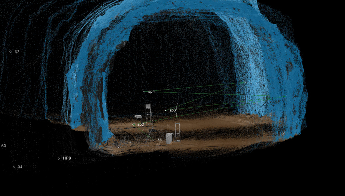
The blue tunnel shape created with TBC. SP stands for station point and the two green lines show where the SX12 locked on to two fixed prisms to measure De Vuyst’s position.
As darkness is the one constant in the tunnels, it has been crucial for crews to have reliable reference points to know where they are physically in the tunnel and where specific work needs to be done. So one of De Vuyst’s main tasks has been to seamlessly switch between the SX12’s total station and scanner to provide that guidance. Using the instrument’s robotic total station, she has been establishing ground control by setting out prisms at 80-m intervals along the tunnel walls. With those fixed points, De Vuyst maintains a project control network accurate to 0.005 meters.
To easily and reliably guide the four teams of 40-50 people working in the tunnel, De Vuyst uses the total station scanner to establish and measure a “meter line”, a horizontal line sprayed every 10 m that indicates the 1-meter mark above the Maursund’s future new road. “The existing road has steep grades descending down around 80 m and it curves so it isn’t a reliable reference,” says De Vuyst. “We know the elevation and design of the new road so I can use that theoretical data and the SX12 to measure and set out the meter line, which not only gives crews a physical position in the tunnel, it provides a marker to follow for determining their own work such as laying cables or installing reinforcing materials on the walls. To lay that out with a traditional total station would require hours of multiple set ups but with the green laser range and speed of the SX12, I can capture the survey data in minutes from one position.”
Volumes of volumes
The SX12 stands at the ready outside one of the Maursund’s technical buildings.
If there is one word that often dominates De Vuyst’s day, it is “volume”. With the routine blasting and digging to both widen and heighten the Maursund, De Vuyst is constantly checking and calculating volumes to confirm teams have removed enough material to create a 6-m-wide carriageway with a 1.2-m shoulder on each side and a clear height of 4.6 meters.
And she has had to be creative with machine control since none of the diggers on site are connected to universal total station (UTS) positioning technology. To resolve this, De Vuyst first created a 3D model of the tunnel’s “driving box”, the pre-defined height and width needed to allow vehicles to safely drive through. Scanning 60-m sections of the tunnel, she imported the 3D data into Trimble Business Center (TBC) to create a model of the road and then input the 6-m-wide and 4.6-m-high driving box dimensions to produce a linear 3D drawing of the box. She imported it into Trimble Access Tunnels software and saved it as master file on a Trimble TSC7 controller, enabling her to quickly check earthworks progress any time by positioning the SX12, measuring any point, and immediately identifying any underbreak in relation to the driving box perimeter visible on the controller’s graphical interface.
She has also been creating 3D “profile prints”, drawing files that provide the tunnel shape, tunnel bottom, driving box, and a numbered position marker for tunnel orientation. Once a section has been blasted or dug out, De Vuyst positions the SX12 and captures a full-dome scan to collect a georeferenced point cloud of the 60-m area. She integrates that data into TBC and using the software’s specialized Tunnel module, she uses a classification tool to automatically clean and process the data to create a tunnel shape—a process that takes 3 minutes per scan.
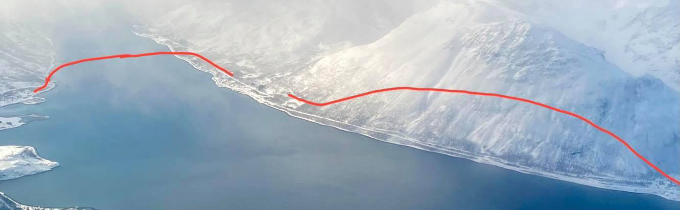
The view of the project site from above. The red lines indicate the two tunnels—Maursund on the left and Kågen on the right.
“The scanner captures everything it sees—people, cars, even water droplets—as well as the tunnel shape,” says De Vuyst. “Without the automatic classification tool in TBC, I’d have to manually select each bit of noise and delete it. That feature, along with the automatically georeferenced scans, saves me hours of processing time. And because I know I can eliminate noise automatically, I don’t worry about passing traffic or objects in the way.”
Once she has the tunnel shape, she can combine survey controls with the density of points to calculate and verify earthwork volumes as well as convert the 3D model to a tunnel profile drawing, indicating precisely where more sediment needs to be removed and how much. Digger operators then use the prints in their cab as a machine control guide.
“I make profile prints of the tunnel at every half meter,” says De Vuyst. “That allows everyone to monitor progress at set intervals. Crews can not only see how the tunnel looks now, I can provide historical views to show how the tunnel looked a week ago or even at the beginning of construction. It’s incredibly helpful for measuring and monitoring progress.”
The ability to efficiently produce tunnel profiles was particularly beneficial for preparing and positioning Maursund’s technical building, which is set in the tunnel center, 93 m below sea level.
Teams needed to blast out a space 5 m deep by 20 m long. Precision was paramount because the building’s pre-fabricated construction was designed to within only a half-meter of the tunnel wall and the top of two of the building’s corners. De Vuyst used the SX12 to as-built and calculate the excavation volumes based on two profile prints for the same area to ensure the space was correct. In early June, crews successfully constructed the technical building.
Locked and bolted
In addition to checking and calculating volumes, De Vuyst has also been consumed with bolts—prism bolts, reinforcement bolts, lighting bolts and signage bolts, all of which she has either been taking as-builts of or setting out.
Of the roughly 170 bolts she has set out, the most challenging to precisely position were the bolts for road signs that will be installed in the tunnel. The bolts needed to be set at a minimum height of 2.2 m above the finished road but at the time, a ditch for underground cables had been dug, making access to properly mark the positions difficult. De Vuyst resolved this with the SX12’s green laser and a truck with a hydraulic bed.
With a tunnel shape model as a base, she used the defined design plans and national height specifications to determine and draw set-out lines indicating where the bolts should be placed. She then imported that 3D file into the TSC7’s Access software. Setting up the SX12 about 20 m from the truck, she used the set-out function and let the scanner’s green laser navigate to the corresponding line. From there she used the controller to move the laser along the line until it hit the precise break point. The person on the truck could then mark the tunnel ceiling at the exact bolt position.
“The clarity, precision and range of the green laser made the task so much easier,” says De Vuyst. “Even at 100 meters away, points are crystal clear.”
With one kilometer of the Maursund tunnel now complete with installed bolts, reinforcement materials, concrete fire protection, and 8.5 billion 3D points, De Vuyst will continue to do more of the same for the last half of the Maursund and the full length of the Kågen to meet the completion deadline of fall 2022. De Vuyst may still not know what to expect as work continues, but she’s confident the versatility of the SX12 will light the way.
Mary Jo Wagner is a freelance writer who’s covered the geospatial industry for 25 years. Email: mj_wagner@shaw.ca.