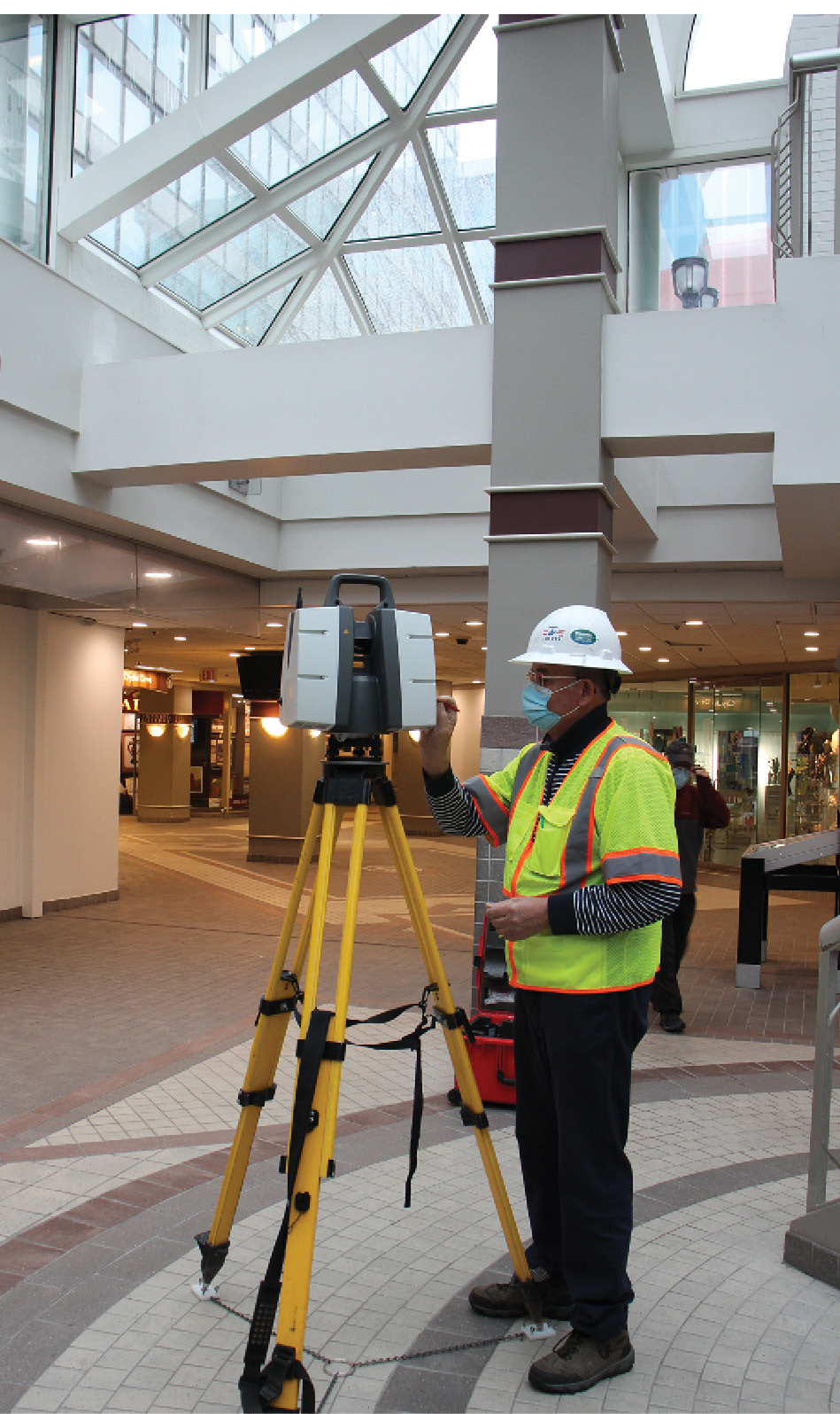
Pandeli Stoja, PhD, A Bowman surveyor running the laser scanning field operations. Safety is paramount and woven into the Bowman culture, even within climate-controlled spaces such as these pedestrian tunnels.
The Washington D.C. area, known for its landmarks and bustling urban life, is also a hub of activity for engineers and surveyors. These experts are engaged in development and redevelopment—often at the same time.
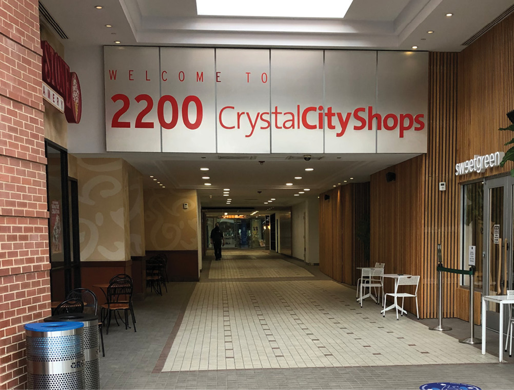
The Crystal City area of Arlington County, Virginia is named in a nod to a prominent crystal chandelier in the lobby of the first building built in the community. It is an urban area with a dense network of commercial buildings connected by a labyrinth of underground tunnels. Since the tunnels were finished in 1976, they have been in continuous use with little change, but aboveground, the city, along with surrounding areas, is being revitalized as part of the National Landing redevelopment plan transforming Virginia’s Arlington County.
A public-private initiative led by Maryland-based real estate development firm JBG Smith, National Landing is on track to be the region’s premier mixed-use urban community and the largest walkable downtown in Virginia. Encompassing Crystal City and portions of Pentagon City and Potomac Yard, National Landing is a vibrant, transit-rich location overlooking our nation’s capital with over 17M sq. ft. of existing commercial space and more than 150 acres of developable land. The redevelopment connects these urban districts with three Washington Metro stations, provides diverse housing options, 60+ acres of parks and green space, 150 restaurants and shops, and supports an aggressive plan for continued growth.
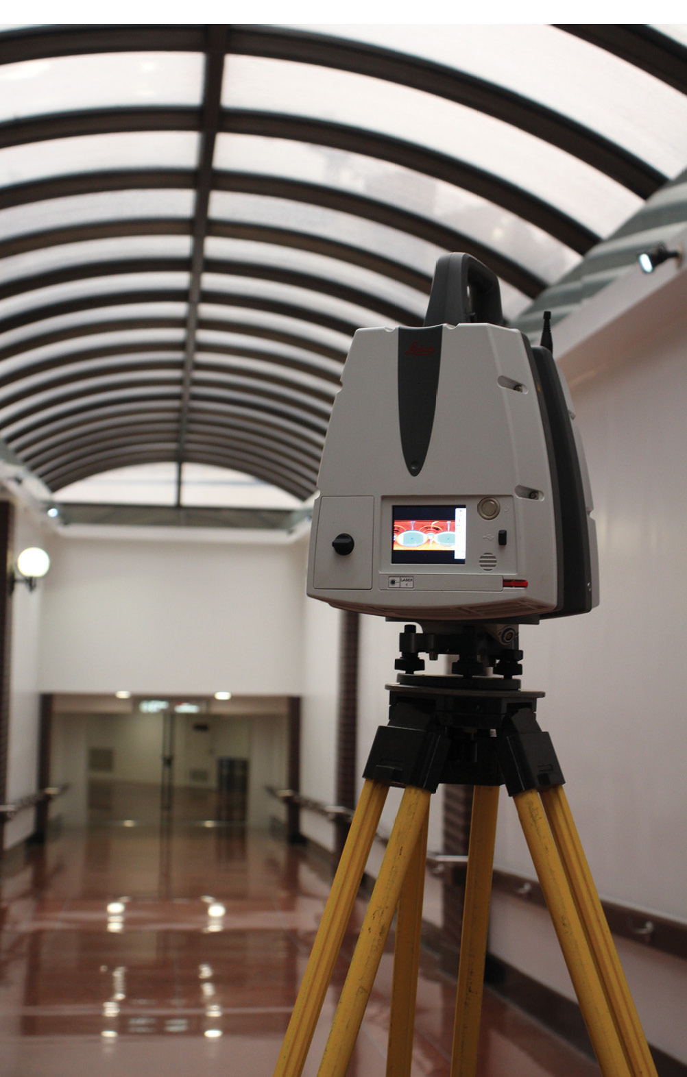
Laser scanning is an integral part of many Bowman survey projects. With a variety of instruments in our inventory we can deploy the right scanner for any project.
Bowman is a leading consultant on the project, providing full engineering design and surveying services on approximately a dozen different sites throughout the Arlington, Virginia area. The project sites include asset repositioning, complete redevelopment, and open space delivery, including green infrastructure, transit, mixed-use, and walkability components. Bowman’s broad scope of work benefits the many aspects of the overall project and surrounding areas. The community will realize the many benefits associated with these projects, including conveyance of the land for future parks, committing to sustainability in construction and operation, constructing new connector roads and protected bike lanes, allocating space for dedicated transit lanes, major intersection improvements, and enhancement of streetscape and open spaces. There will also be increased access to space for businesses, driving additional jobs.
These projects provide incremental realization and fulfillment of the client’s vision for a more vibrant, sustainable urban village with a better mix of offices, retail businesses, homes, and public open space, as well as improvements to the system for all modes of transportation.
In addition to scanning the pedestrian tunnels at Crystal City, Bowman has scanned and modeled over 1M Square feet of underground parking garages, building facades, landscaping and roadway corridors.
“This project and Bowman’s services will bring many benefits to the local community here in National Landing,” said Scott Delgado, Vice President at Bowman. “Knowing that our work brings their vision to reality is motivating.”
When asked how Bowman is poised to tackle a project of this magnitude, Mike Bruen, Chief Operating Officer at Bowman, credits the diversity of services and expertise of their dedicated staff. “Bowman’s multi-disciplinary service offerings are supported by incredible teams of industry-leading talent who seamlessly collaborate to deliver innovative and solution-driven results without compromising on quality,” Bruen shared. “With roots in the DC area, it is exciting to be part of this large-scale revitalization effort and make a difference on a project that is in our own backyard.”
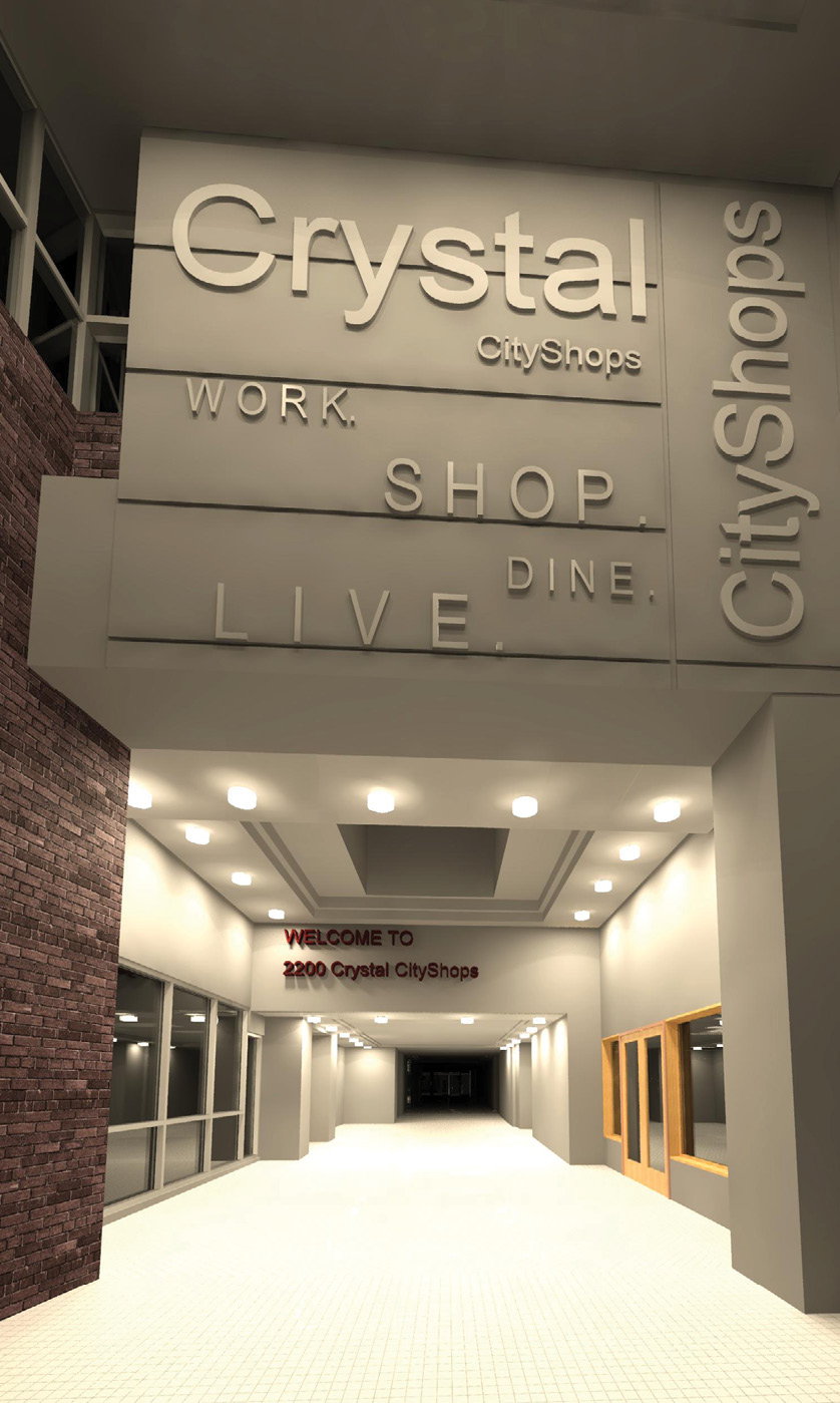
3D modeling was used to support 3D design. Revit model renderings are an excellent way to share snapshots of the 3D models.
The Bowman team recently provided surveying and 3D scanning services for the pedestrian tunnels and much of the existing underground parking garage network, and performed significant site surveying, utility locations, and as-builts for the civil and architectural design.
Bowman developed a highly accurate GNSS and conventional survey control network to support surveying efforts including detailed field run and LiDAR topographic surveys, boundary and ALTA/NSPS Land Title Surveys, utility as-builts, construction staking, construction as-builts, and platting. For the pedestrian tunnel project, Bowman is surveying approximately one mile of tunnels from 12th Street through 23rd Street utilizing laser scanning (LiDAR) technology. A combination of traversing with a total station, running digital differential level loops, and collecting static LiDAR was performed to produce an as-built 3-dimensional model of the general tunnel layout below the city.
The project mapped out the precise location of the tunnels to within 1.5” and assisted with development plans for the area. The scans were done in segments, with surveyors strategically placing removable targets along the route. Bowman surveyors started their work above ground on one side of the project and worked along the tunnel corridors until an entry/exit point was reached. At every entry and exit point, surveyors “daylighted” with the field operation and tied into known control points. A methodic and planned field operation moved through the pedestrian tunnel system along the maze of tunnels. This intricate network of data collection was processed and adjusted into a seamless and accurate LiDAR point cloud. The LiDAR data was uploaded into Leica Geosystems’ Jet Stream point cloud environment where multiple 3D modeling technicians could work with the data set efficiently. Bowman 3D modeling experts then commenced to generate a 3-dimensional Revit model of the tunnel system. The main general elements were drafted and included walls, floors, ceilings, columns, stairs and staircases, shop and restaurant entrances, glass partitions including mullions, and skylights.
The Crystal City pedestrian tunnels provided a great place to survey during the winter months and with low foot traffic volumes due to COVID-19.
Above ground, Bowman’s survey team created design quality base maps for multiple city blocks. These efforts started a few years ago and grew to include 35 parcels with associated easements and mapping. Traditional survey methods were used in developing these design quality maps. Title reports and county courthouse records were thoroughly reviewed with the designers and land use attorneys. Then, careful effort was put into the computation and location of property corners to help define the urban parcels. Traditional instruments, robotic total stations, and GPS were all used in combination to locate physical features and create 3D maps showing major grade breaks and critical elevations. Ultimately, office and field data were melded together to create maps showing the above ground features, building footprints, easements, and elevations, all of which are certified per state code and sealed by licensed professionals.
The land surveying portion of these projects did come with challenges the Bowman team had to overcome. One of the challenges was a flight restriction zone for drone mapping. National Landing is located between the Pentagon and Washington’s National Airport. Drones have become a go-to tool for larger scale mapping, but in this area are not permitted due to security concerns from the federal government. The flight restrictions effectively grounded any plans to perform survey data collection from UAV platforms.
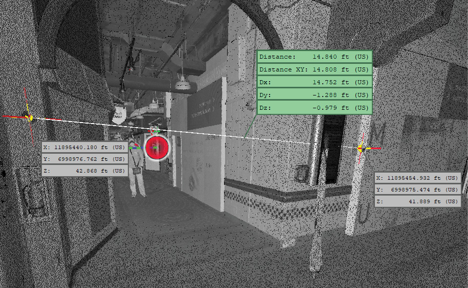
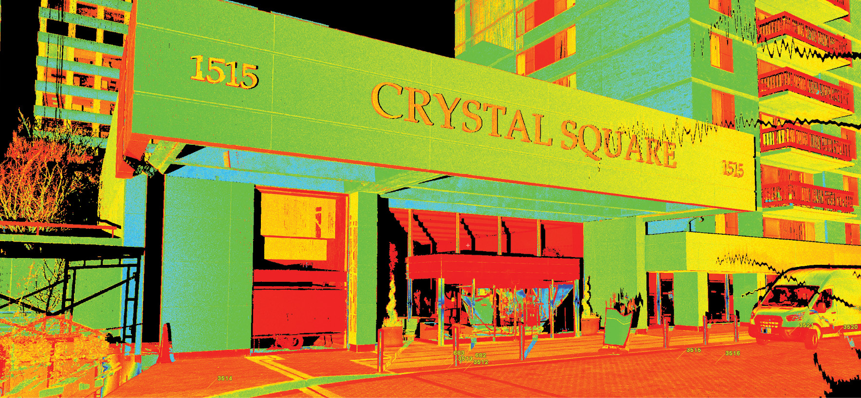
Bowman takes quality assurance and control seriously. This image is an example of verifying the inverse between control points and comparing them to the conventionally surveyed values.
Another obstacle overcome was defining and mapping the dense urban property system over a large area spanning several blocks. Due to decorative brick sidewalks and other hardscape features, this area is not monumented in the ground with traditional iron rods as is typical in most other places. Cross cuts, or chiseled cuts in tops of curbs are the primary places for survey ground control points or property offsets to be set and found. Due to spot utility installations or maintenance, portions of these urban curbs were replaced over time, losing this information. The solution involves conventional locations of buildings and comparison against record information, along with other found physical evidence that confirms record parcel limits.
“What an honor to work alongside the respected professionals with JBG Smith to support development around Amazon’s new headquarters. Our collaboration allows both firms to leverage the perfect skills and talent for success on such a large-scale project,” said Obadyah Foord, Regional Survey Director for Bowman. “We are excited to be a part of this redevelopment project that is helping to create a thriving, easy to navigate urban community.”
Bowman’s breadth of experience makes any challenges easier to navigate. The tunnels are open to the public and are in a high-traffic location. This can cause problems for surveyors because the laser scanning equipment needs a clear line of sight to its targets to accurately capture the data. The pedestrian tunnels were open during their field operations and many targets were knocked over or moved by patrons of the tunnels. Bowman surveyors also navigated the challenges of inclement winter weather that brought several snowfall events. Other planned area-wide events impacted the field operations, the more notable of such events was the 2021 Presidential Inauguration.
“Luckily, with the tunnel portion of the project, we can continue through the climate and poor weather conditions that caused others to shut down their sites,” said Charles Powell, Vice President of Bowman. “We take the time up front to predict and think through the resolution of any potential challenges. Despite the few challenges we face, our progress has streamlined, and we are working efficiently to get this project completed on the estimated deadline date.”
The tunnels are of sentimental value to many who grew up with them. Some of Bowman’s employees, including Powell, recall spending time at tunnel shops and the theater as a teenager. “I grew up in Arlington and spent much of my high school years and after high school years, during the mid to late 70’s, in Crystal City patronizing the underground shops and restaurants. It was a great place to hang out,” said Powell. “It is surreal to know what they were then, and I am excited to now provide my expertise for renovating the tunnels.”
In a massive project like this, the surveying challenges are just the beginning; the base information developed is the basis of design or starting point for Bowman’s engineering teams. Accurate surveys of the underground facilities, including tunnels, garages, and utilities, within National Landing are paramount to the success of the engineering design. Since the underground tunnel and garages extend under and across the streets of National Landing, a primary engineering challenge is connecting utilities along the street grid to ensure system redundancy when these underground elements may prevent connectivity. Buildings situated where the tunnels and garages prevent direct routes for the installation of utility services require alternative strategies and extensive planning to ensure that all elements work cohesively.
Headquartered just a few miles from National Landing in Reston, Virginia, Bowman is a leading multi-disciplinary consulting firm offering a broad range of real estate, energy, infrastructure, and environmental management solutions to both public and private clients across the country. Their more than 780 total employees work together in over 30 offices nationwide, and with clients in nearly every industry.
The thoughtful work of careful surveyors and engineers, like those at Bowman, are integral to the maintenance and creation of great American cities.
While Bowman has an extensive list of projects involving land surveying and engineering services, their breadth of expertise makes them a top service provider for complex projects like the National Landing project. Their design services encompass site design, intersection and roadway design, large utility relocation design, maintenance of traffic, pedestrian and ADA facility design, and dedicated transit lane design. Bowman teams also perform cycle track design, 5G infrastructure design, SWM, green roof and bio-retention design, topographic and boundary surveys, GNSS control surveys, UAV and terrestrial LiDAR services, full 3D and 2D plan development, ROW and easement plat development, FAA plat development, arborist services, landscape design, water network design, streetscape development, and full construction administration services. Their services also include surveying, civil engineering, MEP engineering, subsurface utility engineering, land planning, environmental consulting, construction engineering and management, landscape architecture, and right-of-way acquisition.
Obadyah Foord, Regional Survey Director at Bowman, is a surveying team lead on this project. His areas of focus at Bowman include LiDAR and Surveying Technology. He is a licensed surveyor and is a certified mapping scientist with ASPRS.