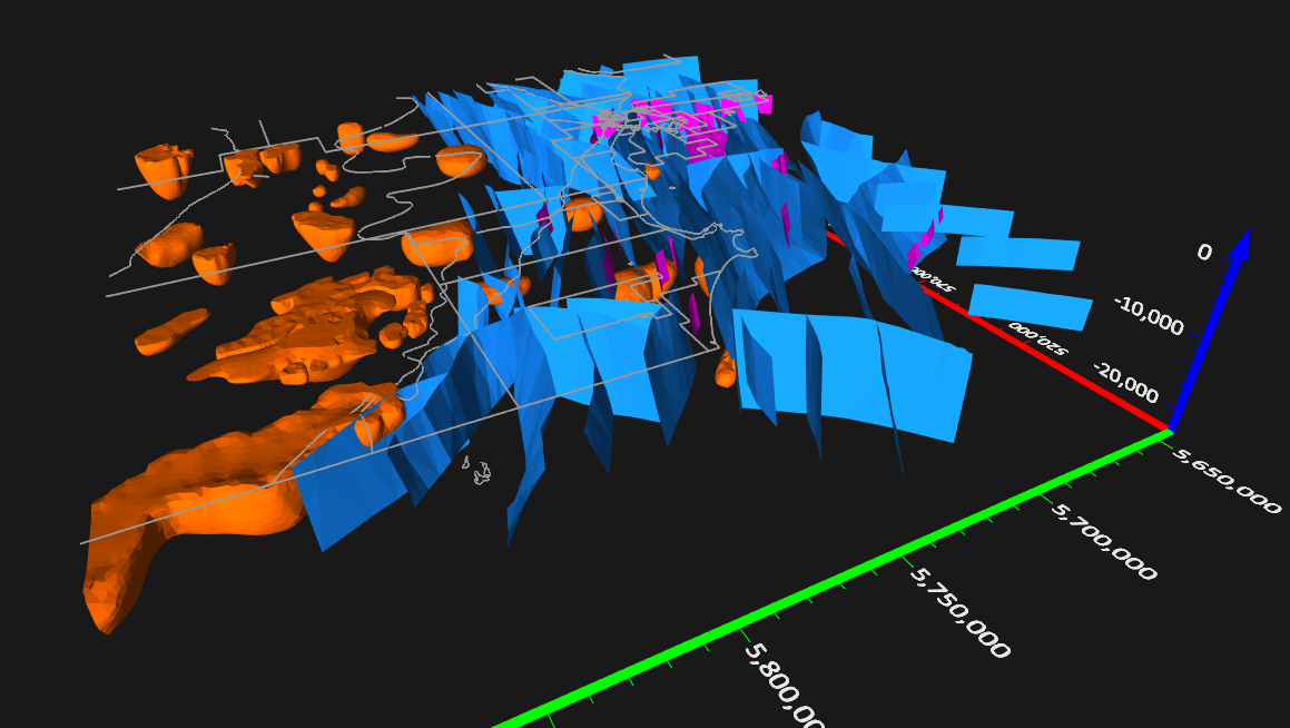
Display 3D polygons from DXF files, such as fault planes and magnetics data, in the 3D View.
Golden, Colorado, 11 May 2021 – Golden Software, a developer of affordable 2D and 3D scientific modeling packages, has added new and enhanced 3D capabilities to the latest version of its Surfer® gridding, contouring, and surface mapping software. New functionality available now, as well as capabilities in Beta development, are focused on making it easier for Surfer users to visualize, display, and analyze complex 3D data.
The Surfer package is used by more than 100,000 people worldwide, many involved in oil & gas exploration, environmental consulting, mining, engineering, and geospatial projects.
“Modeling and mapping in 3D are tasks that nearly every Surfer user relies upon, and we are committed to upgrading these functions with every software release,” said Kari Dickenson, Surfer Product Manager.
Known for its fast and powerful contouring algorithms that regularly outperform more expensive packages, Surfer enables users to model data sets, apply an array of advanced analytics tools, and graphically communicate the results in ways anyone can understand. The software has been applied for more than 30 years by users in numerous disciplines to easily visualize and interpret complex data sets.
Golden Software has made the following enhancements in the latest Surfer version released today:
3D Base Maps – .DXF, .SHP and other file formats can be imported with their 3D geometry (3D polylines, polygons and polymeshes) and displayed as three-dimensional features in the 3D View. In addition to importing 3D base maps, users can draw custom 3D features, such as polylines and polygons, and add them to the model. This is ideal for visualizing buildings, pipe systems, roads, or streams in Surfer models.
Contour Volume/Area Calculation – A new shortcut enables users to calculate volumes and areas above, below, or between contour lines with just a few clicks of the mouse. This function has been requested by Surfer users in every science and engineering discipline.
3D PDF Exporting Options – Users now have the option of exporting PDFs at different resolutions and file sizes.
More Automated Features – Automation functions have been added for creation of scripts and workflows, including: Point Sample, Grid Project, new Classed Post layer options, and Label Options for the Degrees Minutes Seconds (DMS) label format.
Surfer Beta Available
As is the tradition, Golden Software has released a Beta version of Surfer simultaneously with the new version to give customers a chance to try out new features while they are still in development. Users may find the Beta version by clicking File | Online from within Surfer.
“Beta features available now have been under development since last year and are among the most requested by our user base,” said Dickenson.
Here are the new features available in Beta now, to be officially included in the Fall 2021 release of Surfer:
- 2D/3D Drillholes – A powerful new visualization tool, Surfer easily imports drillhole data to generate a 2D drillhole layer that shows the location, deviation, and path of each hole, core, or well. Users can view the path in a 2D map view and then visualize the drillhole in true 3D along with its data content (e.g., contaminant concentration, mineralization concentration, assay results, geophysical properties, etc.) Drillhole paths, data points and intervals can be displayed and colorized by data values.
- Alpha Shape Boundary Creation – Create a tight polygon boundary around data points in post, classed post and base layers or directly from any data file, even in concave areas. Control how tight the polygon is shrink-wrapped to the data limits. Use the polygon boundary for assigning NoData or delineating coverage area.
- Easy Isopach Calculation – Surfer accurately measures the true stratigraphic thickness of a unit or layer regardless of its orientation. This is especially useful in measuring underground geologic horizons that have been tilted at an angle away from horizontal.
- Fast Grid Math and Grid Volume Calculations – Grid Math enables users to perform mathematical calculations using one or more grid files. Similarly, Grid Volume can determine the volume between an upper and lower grid surface. These calculations were always possible in Surfer but only between grid files with the exact same geometry – a rarity. Surfer now allows users to perform these calculations with grids of different sizes and different X and Y value extents.
About Golden Software
Founded in 1983, Golden Software is a leading developer of affordable scientific graphics software. Its customer base includes over 100,000 users involved in environmental consulting, oil and gas exploration and extraction, mining exploration and extraction, engineering, applied science, business, education, and government in nearly 190 countries and territories. Golden Software offers four products: Surfer® for gridding, contouring and 3D surface mapping; Grapher™ for 2D and 3D graphing; Voxler® for 3D data visualization; and Strater® for well log, borehole and cross section plotting. For additional information, visit www.GoldenSoftware.com or call 1-303-279-1021.
