Here is guidance for locating your own micronation offshore of the United States. The extents of the U.S. maritime zones are highlighted in orange text. (Click to enlarge) Chart courtesy of NOAA Office of Coast Survey.
I recently watched a movie called “Rose Island” that sparked my curiosity. The plot is based on the true story of an Italian engineer, Giorgio Rosa, who built a 400 square meter platform on metal columns in 1967 just outside territorial waters to be free of Italian rule. Rosa declared himself president of the Respubliko de la Insulo de la Rozoj, or “Rose Island” in its official language of Esperanto. But small countries can have big jurisdictional problems. The Italian government viewed the restaurant, souvenir shop, and bar on the man-made island dimly, and to combat what it considered tax evasion, invaded and destroyed Rose Island in 1969.
Although badly dubbed from Italian (mouth movements and some definitive gestures mismatched with English-speaking voices), the film started my surveyor’s brain working out the land and sea rights associated with this undertaking. First question: do Italian territorial waters extend the same distance from shore as in the United States? Rose Island was 11.6 kilometers from the Rimini coast, just beyond the Italian 11 km limit (about 6.8 miles).
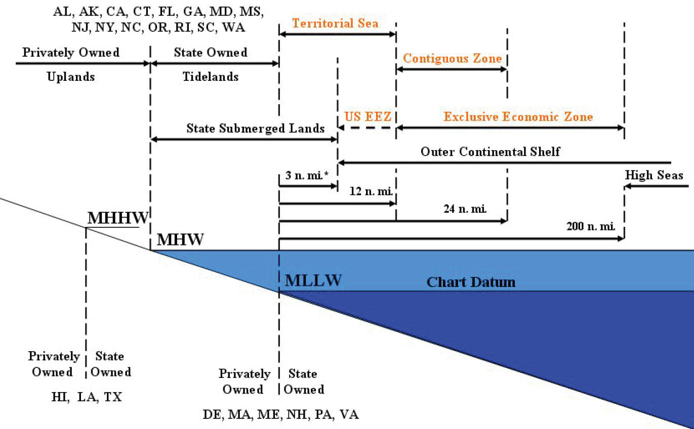
Throughout the world, the extent of territorial waters from shore has evolved over time. For centuries, there was recognition of three nautical miles from the shoreline of any country (the distance a cannon shot could be fired) as territorial waters. This extent changed in the mid-20th century with the work of a United Nations Convention on the Law of the Seas, which established 12 nautical miles, or about 13.8 land-based miles. This has been adopted by numerous nations around the world, including the United States, but it is neither mandatory nor does it overcome any nation’s own laws or customs. What if Rose Island had survived and had adopted the 12 mile limit; what would its effect be on the Italian shoreline? Or vice versa?
Interesting trivia turned up in researching more about Rose Island. Considered a micronation, I learned that its primary uniqueness was in being a purpose-made construct. But off the coast of England another tiny “country” also formed in 1967. Declared an independent nation by retired British Army Major Roy Bates and his family, the Principality of Sealand still exists on the offshore naval fortress abandoned by the military after World War II. Only 7 nautical miles from the British coast, Sealand asserts its sovereignty by being “grandfathered” to the 3 nautical miles of territorial claim at the time of its construction (thus then being in international waters) rather than the current 12 nautical miles—and claims its own 12.5 nautical mile extent of territorial waters, in direct conflict with the laws of the United Kingdom.
Further complicating property rights claims is one of the many commercial undertakings by the Principality to raise funds for its maintenance. While knighthood and royal titles are available for various fees, the public is also invited to purchase one square foot of “Sealand territory” for just $29.99. It isn’t clear whether that square foot is underwater or on the surface of the approximately 10,000 square foot elevated former fortress, so if you want to plant a flagpole on your property it could be a wet proposition. Further, the Principality’s website states: “The period of ownership is limited to 10 years and after this time can be renewed for a nominal fee set by the State at the time of renewal.“ This amounts to a determinable fee, if in fact it is fee ownership at all. Aside from the novelty of “owning” a piece of the territory, is it possible that someone could buy up all the available shares and then take over property usage, erecting buildings or creating easements or leasing to outside entities? I doubt that the Bates family Principality has established land use and zoning regulations. Are there other limits beyond the time associated with this “ownership”?
Several other water-based micronations have existed over the years. Closer to the US, New Atlantis was founded on a 240 square foot concoction created by Leicester Hemingway, brother of Ernest. Leicester formed his floating nation in 1964 after building what was basically a bamboo raft, anchored to the shallow sea floor 50 feet below by a railroad axle, rocks, and an old Ford engine block 6 miles off the west coast of Jamaica. (At that time, the limit of Jamaica’s territorial sea was three miles.) Presumably the headquarters of his International Marine Research Society, the island housed Leicester and his wife, two young daughters, and two other adults for the few years of its existence before being destroyed by a tropical storm. Aside from plagiarizing the US Constitution and Leicester’s election as President in 1965, it isn’t clear that there was much governance of this short-lived 8-foot by 30-foot nation, and probably no internal property issues to deal with. Its main activity seems to have been the publishing of postage stamps for income, later to be a source of revenue for Rose Island and Sealand as well.
For those dreaming of owning their own uninhabited island without having to construct it on their own, the 1856 US Guano Island Act may be the answer to your prayers (see 48 US Code §1411 et seq.). The Act provides for exclusive right of occupation but requires the new possessor under this US law to be a guano entrepreneur. This Act was, incidentally, the basis for the founding of New Atlantis.