A History that Needs Telling
An introduction from Bryn Fosburgh, senior vice president, Trimble
 More than a year ago, I had a chance to have dinner with one of my colleagues from the early RTK development days, Steve DeLoach, a retired civil engineer and land surveyor with the U.S. Army Corps of Engineers. We hadn’t seen each other in decades, and our meeting gave us a chance to reminisce about those long days and challenging problems in our efforts to define GPS surveying techniques for more accuracy, faster initialization, on-the-fly movement and real-time data. We talked a lot about the many smart people who collaborated—sometimes across government and private sectors—to develop a revolutionary technology.
We also wondered if this important history was getting away from us. Did younger surveyors know the origins of a technology that’s part of their daily workflows? Probably not, but they should have access to it if they are interested, because it was really an incredible time in the history of surveying.
With that dinner conversation, Steve and I landed on the idea of an article about the history of RTK. Steve reached out to Marc Cheves at The American Surveyor about publishing it, and Marc agreed. Soon, there was an email chain and phone interviews to collect the memories of Steve, as well as Dr. Benjamin Remondi, a retired GPS technologist from the National Geodetic Survey and Trimble; Kurt Maynard of Trimble and formerly John E. Chance & Associates; and Mark Nichols, Timo Allison, and Nick Talbot, long-time Trimble leaders who were integral in the development of the first commercial RTK systems.
Their memories reminded me of how far we’ve come. I’m amazed that in the more than four decades after the launch of the first satellite for the Global Positioning System, we’ve gone from using a map and compass or laser to locate ourselves from hundreds of meters, to today—when everyone can get a fairly decent location using their phones and watches. Today, RTK boosts GPS accuracy for real time positioning within a few centimeters and serves as the foundation of a billion-dollar-plus precise positioning industry in construction, agriculture, surveying, transportation and logistics.
So rich is the history of RTK, it would take a book to do it justice—and maybe someday, someone will write it. For that reason, this series doesn’t aim to be comprehensive, but instead offers some historical snapshots told by people who were involved in the development and commercialization of this seminal technology.
So please join us on an abbreviated tour of the complex and innovative journey of RTK development, including:
- key individuals who saw potential in using GPS to solve surveying problems;
- technological forerunners, research and breakthroughs;
- the early 1990s heyday of closing in on the biggest technical challenges; and,
- RTK commercialization.
Since its heyday of development roughly three decades ago, Real Time Kinematic (RTK) has far surpassed the dreams of its early innovators.
 Those dreams started taking shape as civilians saw the potential of leveraging the military’s new Global Positioning System (GPS), launched in 1978, to improve challenging positioning and navigation issues in marine and land surveying. The system was designed to use code-based signals for real time accuracies of 3-to-5 meters horizontal and 10-to-15 meters vertical, but there were ideas on using parts of the signal that the GPS designers hadn’t anticipated.
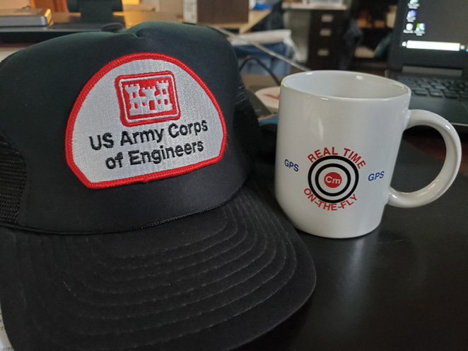
“It’s a great story of a surveying system made by surveyors for surveyors,” said Steve DeLoach, retired deputy chief of engineering and construction for the U.S. Army Corps of Engineers (USACE), which funded significant RTK breakthroughs in the late 1980s and early 1990s to vastly improve dredging operations. “Before RTK, establishing geodetic control, horizontal and vertical, was a massive, labor-intensive endeavor.”
From the late 1970s through the mid-1990s, RTK pioneers saw potential in GPS to solve surveying challenges in accuracy, motion and timing, but they had to attract funding, pursue knowledge leaders, and put in the hard work of testing systems and developing the complex computer algorithms to augment and correct the signals of GPS.
Soon after the launch of the first GPS satellite, Charles Counselman of the Massachusetts Institute of Technology (MIT) developed a GPS receiver called the Macrometer that was based on a radio astronomical technique and suitable for geodetic work. Also around that time, papers from luminaries such as John D. Bossler and Clyde C. Goad (National Oceanic and Atmospheric Administration) and Peter L. Bender (Joint Institute for Laboratory Astrophysics, National Bureau of Standards and University of Colorado) explored the idea of processing GPS carrier-phase signals. (Bossler, J.D., Goad, C.C. & Bender, P.L. Using the Global Positioning System (GPS) for geodetic positioning. ) This new use of GPS was altogether different from the original intent.
International events also had impact. In 1983, Korean Air Lines flight 007 was shot down by the Soviets, killing the 269 people aboard. The aircraft had been traveling from New York City to Seoul, South Korea, via Anchorage, Alaska, when a navigational error caused it to drift into Russian airspace. In response to the tragedy, President Ronald Reagan issued an executive order to make GPS available for civilians at an accuracy of 100 meters.
But many needed something more accurate than what was the intended design of the GPS code signals, so the focus shifted to the static applications using GPS carrier-phase signals. Scientists devoted to geodesy readily adopted GPS carrier-phase processing, developing the mathematics and writing software, which allowed geodetic surveyors to forge ahead with novel methods of establishing horizontal geodetic control with accuracies ultimately at the millimeter level, in three dimensions.
“Now that’s something that surveyors really care about,” DeLoach said.
Industry also responded, crafting GPS receivers for this new idea, such as those by Magnavox and Texas Instruments. These early GPS receivers, while revolutionary in capability, were also large, ungainly and built for specific scientific and surveying applications. This made them unworkable for broad industry applications, but those would come later.
There would be other problems to overcome, such as shifting from static to kinematic surveying, faster initialization, precision for vertical measurements and processing in real time. Accurate static surveying was terrific, but many applications would require high accuracies while moving.
It was those early dreams for GPS, however, that fueled the solutions that would eventually form the revolutionary RTK technology, which today achieves precise, relative positioning in real time. For surveyors, in particular, RTK enables them to be more productive by reducing the need for time-consuming optical surveying methods in many applications.
“Everything was intentional and by design—and yes, we saw the future,” DeLoach said. “But did we see a farm tractor being guided automatically to an inch accuracy? Or a bulldozer cutting and filling with no surveyors putting in stakes, or autonomous cars? Not really, no.”
DeLoach was among those pioneers who played an integral role in early RTK development, and here, we will meet him and two other key individuals to learn about some of the problems they hoped to solve.
Steve DeLoach
A vision for vertical precision for tidal measurement and hydrographic surveying
 Before the advent of RTK, surveying required many field crews to conduct the complex tasks that were necessary for geodetic control. As part of its job supporting the nation’s water-based commerce, USACE used those national control networks to expand local networks along rivers and harbors for the engineering and construction work involved in building, operating and maintaining 25,000 miles of coastal and inland river channels, 14,000 miles of levees, more than 230 locks and 700 dams.
USACE knew the challenges of marine navigation and hydrographic surveying.
 Marine engineering and construction projects relied on a tidal or river datum and establishing that datum and transfer to the marine vessels performing the work was a difficult and expensive task, with vertical accuracies in feet, which introduced significant errors. Less accuracy equated to USACE paying more for dredging operations because payment is typically based on the amount of material removed from a channel. An error in vertical measurement to the bottom correlated to USACE paying millions of dollars more in contract fees.
“The vertical was extremely critical to us,” DeLoach said.
DeLoach had a lofty vision for a dredging research project that focused on getting precise, real-time vertical positioning at the dredge.
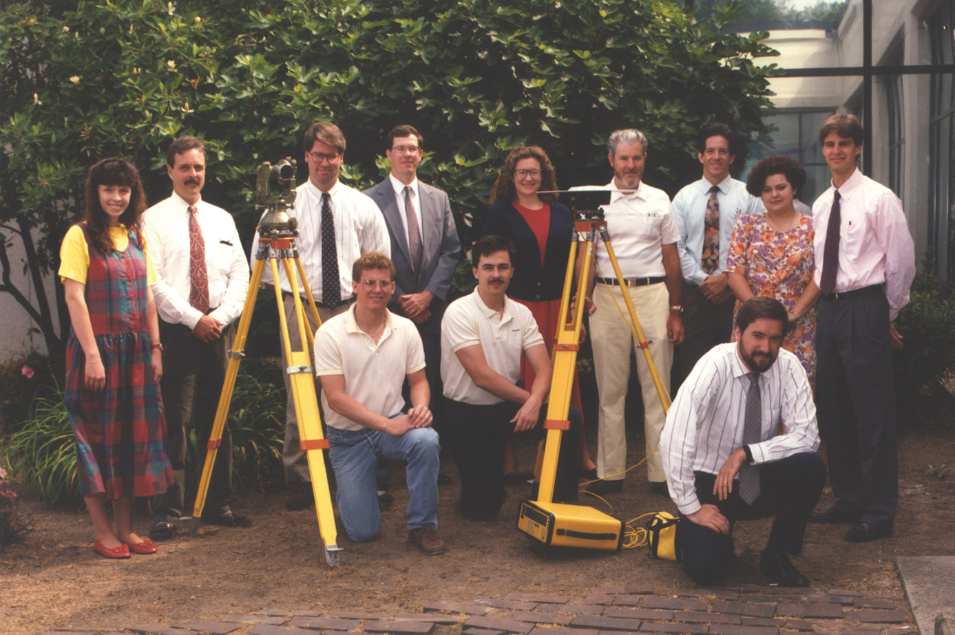
DeLoach (center in suit) with the men and women of the US Army Engineer Topographic Laboratories (USAETL) Precise Survey Branch, which played an integral role in the development of RTK. (July 1992 photo from Rebecca Ragon)
“In the 1980s when I was arguing for funding under the Corps Dredging Research Program, the conventional wisdom was that GPS was good to a few meters, and it was two times worse in the vertical than the horizontal,” DeLoach said. “The geodesists, of course, were doing centimeter-level work but still complained about 1.5-to-2 times worse in vertical. So, many in the Corps research program thought the pursuit of the required accuracies in real time was simply a waste of time.”
But DeLoach, the Corps’ chief surveyor, M.K. Miles, and other leaders in surveying and mapping, research and development and civil works, thought otherwise and would parlay this belief into funding to land the project. With GPS, DeLoach believed it was possible to achieve real-time three-dimensional positions of dredges and hydrographic survey vessels to an accuracy of a couple of inches.
In pursuit of breakthroughs, individuals collaborated to share data and methods, sometimes across public, private and academic sectors.
“We built a team of engineers and scientists—surveyors, geodesists, electrical engineers, civil engineers, mathematicians, computer scientists, physicists—to kluge together the system,” DeLoach said. “We published what we could and hid nothing.”
Any historic look at RTK should recognize not only the relentless efforts by these engineers and scientists—some of the smartest in the world—but also the high school interns who helped process data and the college students who schlepped heavy equipment for testing, DeLoach said. “This is about a lot of people,” he said. “They were all marching in the same direction, and all passionate.”
Benjamin Remondi
Centimeter surveys using GPS
 When it came to problem solving with GPS and software, Dr. Benjamin W. Remondi became a go-to guy for the National Geodetic Survey and a bevy of other government agencies and organizations.
After early career stints at NASA and the Geostationary Operational Environmental Satellite (GOES) program of the National Oceanic and Atmospheric Administration (NOAA) in the 1970s, Remondi believed he’d found his calling in orbital mechanics and software development. “At some point, I faced the fact that I had to become an orbit expert,” he said, so in 1979 he headed to The University of Texas, a leading university on the subject, to gain that expertise.
After Remondi felt like he’d learned everything he could from the Texas program, he returned to his work for the GOES program, content that, “this is my life’s work. I’d love to do this for the rest of my life.”
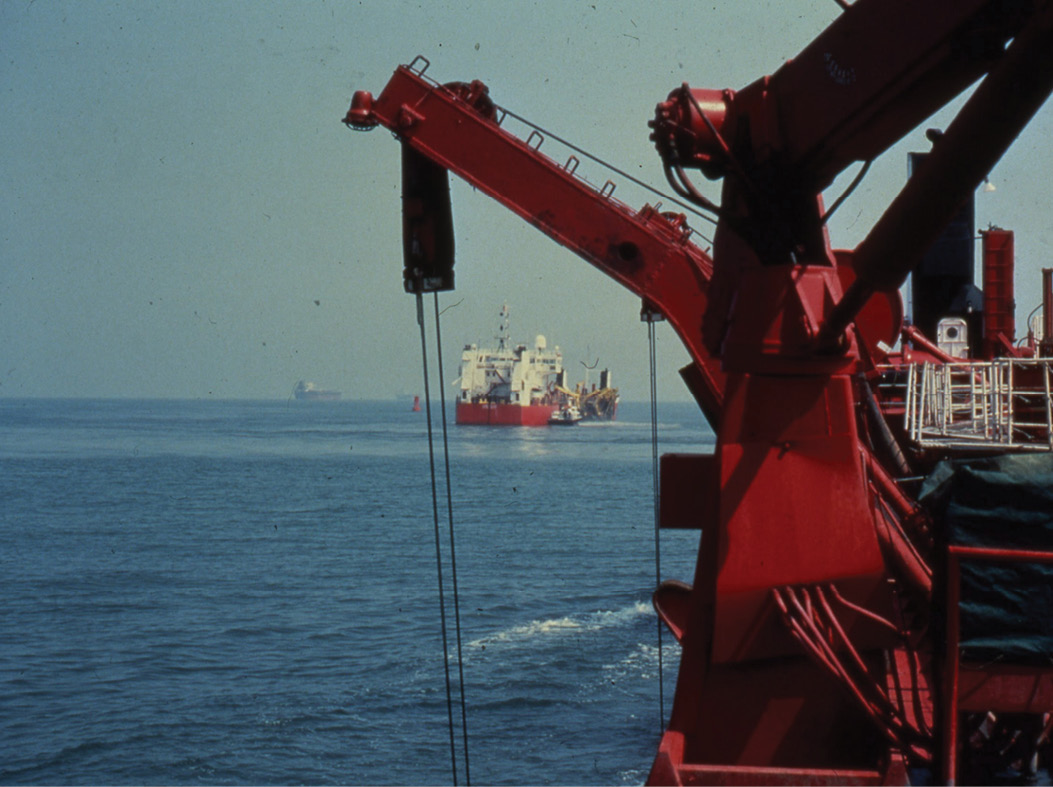
Hopper dredges working in the Lower Chesapeake Bay, Thimble Shoal Channel. (1983 photo from Steve DeLoach)
But soon, he would be presented with a challenge that steered his career in a different direction, and it came from Dr. Clyde Goad, a leading engineer and scientist at National Geodetic Survey who Remondi had met through work for a defense contractor.
Remondi hadn’t planned to do a Ph.D. thesis, but 15 months later, Goad presented an idea, saying: “Ben, I have a really hard problem to solve. No one’s solved it, and it’s worthy of a Ph.D. dissertation.”
After an interview with Goad and Admiral John Bossler, another pivotal leader in geodetic surveying and GPS, Remondi agreed to take the job and pursue the research.
“It was solving a GPS surveying problem using GPS signals for centimeter-or-better accuracy for surveying for the nation,” Remondi said. “It was a big problem, and nobody had software or a model to do that yet.” This work on static surveying, the focus of his Ph.D. thesis, led to Remondi wondering if centimeter accuracies could be achieved while moving. He ran some initial tests on demonstrating kinematic surveying was possible (but not yet in real time) and published a paper on his findings.
That work would lead to researchers in the field referring to him as “the father of Real Time Kinematic survey.”
Mark Nichols
Precision and reliability for surveying applications
 As a high schooler in the 1970s in New Zealand, Mark Nichols spent a summer working for an engineering company on a hydro dam in a rugged part of the country. While the job solidified his interest in surveying and led to a 30-plus year career with Trimble, those early experiences had him questioning if there was a better way for many traditional surveying practices.
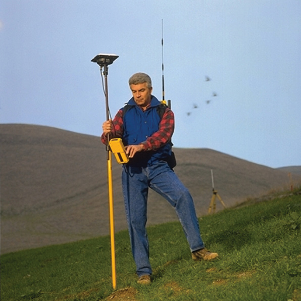
Trimble’s first RTK system with on-the-fly initialization. It included a dual frequency receiver and radio link (in backpack) and a survey data collector to code and store data for automated map generation.
He tells about his first day on the job that summer, when he was asked to measure from the top of a hill to the bottom through some trees, using the then-modern version of a survey chain—a steel tape. “We went to throw it over the trees, and it snagged, and we broke the chain,” he said. “Then you had to get the two pieces, get them together, straighten them out and solder them back together in the field. I looked at all of this and went: there must be a better way.”
Another time, he arrived at the jobsite only to discover that local residents opposed to the dam project had pulled out all of the stakes he’d put in just days earlier to mark construction for the contractor. In that instance, it also registered to him that there must be a better way.
Nichols went on to get his degree in surveying, and then started doing survey work for the New Zealand government, which exposed him to the power of digital computing. Eventually, he picked up a laptop that had a small screen and printer and started writing software to do survey calculations. At a time when feature coding was done with numeric codes, he thought there had to be a better way and led the development of natural language feature coding for automatic map generation.
 That better way—in fact, many better ways that he and the Trimble team would help develop in the decades to come—leveraged GPS to make breakthroughs in precision, initialization and commercial design for RTK.
One key aspect of developing RTK involved solving the integer ambiguity and then continuously processing the measurements.
In the late 1980s and early 1990s, “brilliant engineers around the world were trying to solve this problem,” he said, “and more importantly, solve it with a high degree of reliability.”
“Initially, we solved the integer ambiguity by occupying a known point, which worked for land surveying, and then developed the algorithms to solve it while moving ‘on the fly’ (OTF).” This capability would open up the use of RTK for marine, machine control, and other applications, and simplified the use for surveyors because it automated the initialization, without the need for a point of beginning each time the receiver lost lock.
“OTF,” Nichols said, “was the tough problem that all the teams were racing to solve.”
Check out our next issue for History of RTK—Part 2
Stacey Hartmann writes about surveying and geospatial topics for Trimble Geospatial.